Map of King Street
| Street Crime (updated 06/04/2024) | ||
|---|---|---|
| Location Note | Central Point of Street - Not Actual Location | |
| MSOA Info | For MSOA E02004761 (Statistical Neighbourhood) | |
| Click Hint | Click on a Circle for a detailed breakdown below map. | |
| Crime Levels |
Green = Very Low Yellow = Low Orange = High Red = Very High |
|
| Postcodes | ||
| Icon | Postcodes for King Street | |
| Walking Distances | ||
| Distance Info | Green Circle = 10 Minutes Walk (800 metres) | |
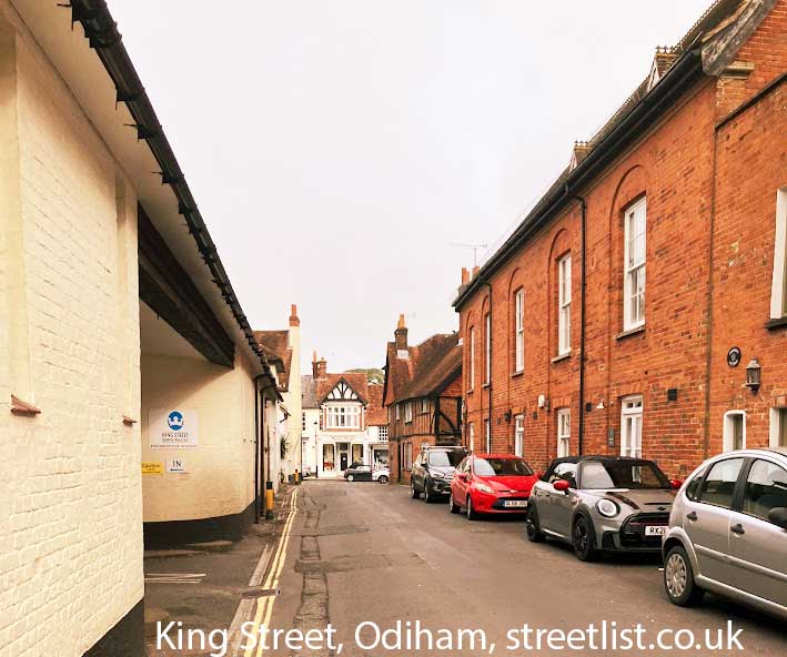
About King Street
King Street is a street located in the village of Odiham. The street has a length of approximately 326 metres.
The street is publicly maintained which means that the road is adopted and Hampshire is responsible for the repair and upkeep of the highway.
King Street is located within the Hart District Council's jurisdiction. They provide various services, like refuse collection, and manage council tax collection. It's situated in the South East region of the UK.
King Street has been assigned the Unique Street Reference Number of 16708390 and 16709436 in the National Street Gazetteer.
King Street is located within the county of Hampshire, situated in the South East region of the UK. It's 39.79 miles South West from central London., 6.25 miles East from Basingstoke, 14.09 miles South from Reading and 15.95 miles West from Guildford.
King Street is within the Post Town of HOOK.
David Caldwell, King Street, Odiham

Do you know why this road is called King Street?
What's it like to live here?
Ask the community a question about King Street.
Do you have any questions, memories to share or know any facts about King Street? We'd love to know more.
Also on streetlist.co.uk, can you help?
Eldroth Road
15th April 2024
I wondered if anyone has any old pictures of Wenning Bank House in the 1940’s and also Lane Side before of the same era .. we visited today with my Mum in law as she used to live at both these properties. Also any photos of the schools around that time .. thank you.
Can You Help?Napps Way
15th April 2024
Why is the road called Napps Way (belonging to Napp, but minus an
apostrophe as is usual with such nomenclature)? Moreover, who or
what is, or was, “Napp” in the respective, possessive case?
Several years ago, I met an elderly man (probably in his late-eighties)
who lives on Bentham Drive, Liverpool 16, and during a conversation
with him whilst in a Northwest Passenger Transport Ambulance on the
way to the former RLUH (Royal Liverpool University Hospital), he told
me that he could remember (when he was a boy, living in Childwall,
Liverpool 16) that, “Where Napps Way is now, during WW2, there was
a two-man gun emplacement on the, then, open land to protect the
railway line passing over Childwall Valley Road - next to the railway
bridge - when suddenly, as they were loading a live “shell” into the gun’s
breach, the aforementioned “shell” accidentally exploded in the gun’s
breach killing both of the two soldiers, that had been manning the gun,
instantly! (Very sad, of course, but could - perhaps - two ghosts relating
to those two, very unfortunately and prematurely-killed soldiers have
haunted that place of their deaths ever since - and have any residents
of Napps Way - formerly and in its latest incarnation - seen two, WW2
(uniformed) soldiers unexpectedly appear in or near their homes?)
Mauritius Road
15th April 2024
Why is Mauritius Road so called, since when and by whom? Does Greenwich have any particular links with Mauritius? Very interested to know. 🤞🏼
Can You Help?House Sales in King Street
| Year | High | Low | Average | Sales |
|---|---|---|---|---|
| 2010 | £215,000 | £1,105,000 | £660,000 | 2 |
| 2011 | £375,000 | £440,000 | £378,000 | 5 |
| 2012 | £190,000 | £190,000 | £190,000 | 1 |
| 2013 | £462,000 | £465,000 | £463,500 | 2 |
| 2014 | £205,000 | £530,000 | £378,750 | 4 |
| 2015 | £258,500 | £258,500 | £258,500 | 1 |
| 2016 | £970,000 | £205,000 | £542,000 | 5 |
| 2017 | £265,000 | £265,000 | £265,000 | 1 |
| 2018 | £189,368 | £189,368 | £189,368 | 1 |
| 2019 | £484,280 | £525,000 | £504,640 | 2 |
| 2020 | £210,000 | £540,000 | £375,000 | 2 |
| 2021 | £300,000 | £235,000 | £267,500 | 2 |
| 2022 | £350,000 | £460,000 | £405,000 | 2 |
Contains HM Land Registry data © Crown copyright and database right 2024. This data is licensed under the Open Government Licence v3.0.
Estate Agents near King Street
| Name | Address | Website |
|---|---|---|
| McCarthy Holden | 95 High Street, Odiham, RG29 1LA | Visit Website |
| Strutt & Parker | 82 High Street, Odiham, Hampshire, RG29 1LP | Visit Website |
| Hastoe Housing - Odiham | Warren Andrew Drive, North Warnborough,RG29 1JE |
Hotels near King Street
Budget Hotels near King Street
| Budget Hotel Name | Distance (miles) |
|---|---|
| 1: Name:Days Inn Hotel Fleet Address:Welcome Break Service Area, M3 Motorway, Hartley Wintney Telephone: Visit Site |
4.61 |
| 2: Name:Premier Inn Fleet Address:7-11 Fleet Road Telephone: Visit Site |
5.19 |
| 3: Name:Travelodge Fleet Address:Cove Rd, Fleet, GU51 2SH Telephone:0871 559 1821 Visit Site |
6.47 |
| 4: Name:Premier Inn Basingstoke Town Centre Address:Victoria Street Telephone: Visit Site |
6.54 |
| 5: Name:Premier Inn Aldershot Address:7 Wellington Avenue Telephone: Visit Site |
7.00 |
Location Details
| King Street | |
|---|---|

| |
| Latitude | 51.252302 |
| Longitude | -0.938238 |
| OS Easting (X): | 474090 |
| OS Northing (Y): | 150940 |
| OS Grid Reference: | SU741509 |
Ordnance Survey Maps for King Street
If you purchase a map through the links below, we may earn an affiliate commission.
| Map Series | link | Ordnance Survey |
| Explorer 1:25,000 144 Basingstoke, Alton and Whitchurch | Check Price on Amazon | Buy Direct from the Ordnance Survey |
| Landranger 1:50,000 186 Aldershot & Guildford | Check Price on Amazon | Buy Direct from the Ordnance Survey |
Neighbourhood Policing |
| Police Force: Hampshire |
 View Neighbourhood Crime and Policing View Neighbourhood Crime and Policing |
| Find a Local Neighbourhood Watch Scheme |
Frequently asked Questions for King Street
What Council (Local Authority) is King Street in?
King Street is located within the local authority area of Hart Council which is a District Council.
What Parish Council is King Street in?
King Street is located within the area of Odiham Parish Council.
What Electoral Ward is King Street in?
King Street is located within the ward of Odiham.
What County is King Street in?
King Street is located within the ceremonial county of Hampshire.
What Constituency is King Street in?
King Street is located within the constituency of North East Hampshire.
What Part of the UK is King Street in?
King Street is located within the South East (England) region of the United Kingdom.
What County Council area is King Street in?
King Street is located within the Hampshire Council area.
What Police Force area is King Street in?
King Street is located within the Hampshire Police area.
Roads that have a Junction with King Street
| Street | Junction Type |
|---|---|
| South Ridge | junction |
| Church Street | junction |
| High Street | junction |
Sunset and Sunrise times for King Street
| Sunrise | 05:58 |
|---|---|
| Sunset | 20:07 |
Latest Weather Conditions for King Street
| Observed at Weather Station: | Odiham 18 April 2024 at 12:00 (1.02 miles away) |
|---|---|
| Current Weather: | Sunny day |
| Temperature and Humidity: | 11.2°C (49.5%) |
| Wind Direction and Speed: | W (5 mph) |
Population Statistics
| ONS Area Code | E00116302 & E00116304 |
|---|---|
| ONS Area Name | Ageing in Suburbia & Self-Sufficient Retirement |
| Average Age | 46.21 |
| Area Population | 1686.00 |
| Male Population | 796.00 (47%) |
| Female Population | 890.00 (53%) |
| Benefit Claimants | 6 (0%) |
| LSOA Code: | E01022888 |
|---|---|
| LSOA Name: | Hart 011B |
| SOA Code: | 8a |
| SOA Name: | |
| MSOA Code: | E02004761 |
| MSOA Name: | Hart 011 |
Nearest Supermarkets
| Tesco Hook Superstore |
|---|
| Station Rd, Hook, RG27 9JE |
| 0345 677 9352 |
| Distance: 2.11 Miles |
| Directions from King Street to Tesco Hook Superstore |
| Sainsburys Church Crookham Sandy Lane Local |
|---|
| Queen Elizabeth Barracks, Sandy Lane, Chruch Crookham, Fleet, England, GU52 8LH |
| 1252786277 |
| Distance: 4.3 Miles |
| Directions from King Street to Sainsburys Church Crookham Sandy Lane Local |
| Morrisons Fleet |
|---|
| Elvetham Heath, Fleet GU51 1GY |
| 01252 786050 |
| Distance: 4.38 Miles |
| Directions from King Street to Morrisons Fleet |
| Waitrose At Fleet South Services |
|---|
| M3 Motorway, Junction 4a/5, Fleet, Hampshire, GU51 1AA |
| 01252 621656 |
| Distance: 4.59 Miles |
| Directions from King Street to Waitrose At Fleet South Services |
Telephone Information
| Area Code |
|---|
| Area Code: 01256 - Basingstoke |
| Area Code: 01420 - Alton |
| Area Code: 01252 - Aldershot |
Local Government
| Local Council Details |
|---|
| Within the area of Hart |
| Visit the Council's Website |
| Civic Offices, Harlington Way, Fleet, Hants &GU51 4AE |
| Send email |
| Telephone Number: 01252 622122 |
| Local Member of Parliament |
|---|
| Within the Westminster Parliamentary Constituency of North East Hampshire |
| The Member of Parliament is Ranil Jayawardena |
| Details for the MP Ranil Jayawardena on parliament.uk |
| Details for the MP Ranil Jayawardena on theyworkforyou.com |
| In the 2019 General Election Ranil Jayawardena won with a majority of 20,211 the result was Con hold. The total electorate was 78,954 |
| Wards, Parish Councils and County Councils |
|---|
| Ward: Odiham Ward |
| Parish: Odiham Parish Council |
| Ceremonial County: Hampshire |
Nearest Schools
Primary Schools
Mayhill Junior School
Address: The Bury, Hook, Hampshire, RG29 1NB
Headteacher: Mrs Sarah McGillivray
Ofsted Rating: Good (as of 2019-12-04)
Distance: 0.10 miles
Contact: 01256702973
Buryfields Infant School
Address: Buryfields, Hook, Hampshire, RG29 1NE
Headteacher: Miss Lauren English
Ofsted Rating: Good (as of 2019-06-06)
Distance: 0.12 miles
Contact: 01256702667
Long Sutton Church of England Primary School
Address: Hyde Road, Hook, Hampshire, RG29 1ST
Headteacher: Mrs Selena Cameron
Ofsted Rating: Good (as of 2023-09-20)
Distance: 2.17 miles
Contact: 01256862238
Secondary Schools
Robert May's School
Address: West Street, Hook, Hampshire, RG29 1NA
Headteacher: Mrs Rea Mitchell
Ofsted Rating: Good (as of 2022-11-23)
Distance: 1.00 miles
Contact: 01256702700
Calthorpe Park School
Address: Hitches Lane, Fleet, Hampshire, GU51 5JA
Headteacher: Mr Kevan John
Ofsted Rating: Good (as of 2022-12-07)
Distance: 5.56 miles
Contact: 01252613483
Court Moor School
Address: Spring Woods, Fleet, Hampshire, GU52 7RY
Headteacher: Mrs Claudia Beattie
Ofsted Rating: Good (as of 2022-07-13)
Distance: 6.52 miles
Contact: 01252615065
Higher Schools
Queen Mary's College
Address: Cliddesden Road, Basingstoke, Hampshire, RG21 3HF
Headteacher: Mr Mark Henderson
Ofsted Rating: Good (as of 2022-12-09)
Distance: 10.32 miles
Contact: 01256417500
Basingstoke College of Technology
Address: Worting Road, Basingstoke, Hampshire, RG21 8TN
Headteacher: Mr Anthony Bravo
Ofsted Rating: Good (as of 2023-02-03)
Distance: 10.91 miles
Contact: 01256354141
The Sixth Form College Farnborough
Address: Prospect Avenue, Farnborough, Hampshire, GU14 8JX
Headteacher: Zoe Smallman
Ofsted Rating: Outstanding (as of 2021-10-01)
Distance: 13.10 miles
Contact: 01252688200
Nearest Hospitals
| Odiham Cottage Hospital |
|---|
| Address: Buryfields, Odiham, Hook, RG29 1NE, |
| Independent Sector |
| Southern Health NHS Foundation Trust |
| Telephone: 01256 393600 |
| Distance: 0.12 (miles) |
| Directions from to Odiham Cottage Hospital |
| Spire Clare Park Hospital |
|---|
| Address: Crondall Lane, Farnham, GU10 5XX, |
| Independent Sector |
| Spire Healthcare |
| Telephone: 01252 850216 |
| Visit Hospital Website |
| Distance: 7 (miles) |
| Directions from to Spire Clare Park Hospital |
| Fleet Community Hospital |
|---|
| Address: Church Road, Fleet, GU51 4LZ, |
| Independent Sector |
| Southern Health NHS Foundation Trust |
| Telephone: 01252 813800 |
| Distance: 7.36 (miles) |
| Directions from to Fleet Community Hospital |
Nearest Dentists
Dentists near King Street
KING STREET DENTAL PRACTICE
Address: KING STREET, ODIHAM, HOOK, HAMPSHIRE, RG29 1NJ
Distance: 0.05 miles
Contact: :
ODIHAM DENTAL CARE
Address: 45B HIGH STREET, ODIHAM, HOOK, HAMPSHIRE, RG29 1LF
Distance: 0.12 miles
Contact: :
ODIHAM DENTAL CENTRE
Address: THE DENTAL CENTRE, ODIHAM, HOOK, HAMPSHIRE, RG29 1QT
Distance: 0.87 miles
Contact: :
HOOK DENTAL
Address: STANLEY HOUSE, LONDON ROAD, HOOK, HAMPSHIRE, RG27 9GA
Distance: 2.34 miles
Contact: :
2 LONDON ROAD (DENTAL PRACTICE)
Address: 2 LONDON ROAD, HOOK, HAMPSHIRE, RG27 9DJ
Distance: 2.35 miles
Contact: :
ZEBON COPSE DENTAL
Address: UNIT 1, 23 FRENCHMANS CREEK, CHURCH CROOKHAM, FLEET, GU52 0YE
Distance: 3.83 miles
Contact: :
Nearest GP Surgeries
Doctors near King Street
ODIHAM HEALTH CENTRE
Address: DEER PARK VIEW, ODIHAM, HOOK, HAMPSHIRE, RG29 1JY
Distance: 0.20 miles
Contact: tel: 01256 702371
HOOK SURGERY
Address: READING ROAD, HOOK, HAMPSHIRE, RG27 9ED
Distance: 2.58 miles
Contact: :
CRONDALL NEW SURGERY
Address: REDLANDS LANE, CRONDALL, FARNHAM, SURREY, GU10 5RF
Distance: 3.61 miles
Contact: tel: 01252 850292
WHITEWATER HEALTH
Address: THE SURGERY, 1 CHAPTER TERRACE, HARTLEY WINTNEY, HOOK, HAMPSHIRE, RG27 8QJ
Distance: 4.07 miles
Contact: tel: 01252 842087
RICHMOND SURGERY
Address: RICHMOND CLOSE, FLEET, HAMPSHIRE, GU52 7US
Distance: 4.36 miles
Contact: tel: 01252 811466
RICHMOND SURGERY - COVID LOCAL VACCINATION SERVICE
Address: RICHMOND CLOSE, FLEET, GU52 7US
Distance: 4.36 miles
Contact: :
Nearest Dispensing Chemists
Pharmacies near King Street
TOUCHWOOD PHARMACY
Address: 138 HIGH STREET, ODIHAM, HOOK, RG29 1LT
Distance: 0.18 miles
Contact: tel: 01256 702218
BOOTS
Address: FLAT 2, HOOK PARADE, STATION ROAD, HOOK, HAMPSHIRE, RG27 9HB
Distance: 2.33 miles
Contact: tel: 01256 762497
WHITEWATER PHARMACY
Address: READING ROAD, HOOK, HAMPSHIRE, RG27 9ED
Distance: 2.58 miles
Contact: tel: 07811 261922
WELLBEING PHARMACY
Address: 74 HIGH STREET, HARTLEY WINTNEY, HOOK, RG27 8NY
Distance: 4.12 miles
Contact: tel: 01252 842449
THE WELLBEING PHARMACY
Address: RICHMOND SURGERY, RICHMOND CLOSE, FLEET, HAMPSHIRE, GU52 7US
Distance: 4.36 miles
Contact: tel: 01252 624363
ROWLANDS PHARMACY
Address: 5 LINKWAY PARADE, FLEET, HAMPSHIRE, GU52 7UL
Distance: 4.39 miles
Contact: tel: 01252 615582
Nearest Opticians
Opticians near King Street
BROWN AND WHITE OPTICIANS LTD (HOOK)
Address: BOURNE HOUSE, LONDON ROAD, HOOK, HAMPSHIRE, RG27 9DJ
Distance: 2.35 miles
Contact: :
RICHARD WARD EYECARE (HARTLEY MEWS)
Address: THE OLD BAKEHOUSE, HARTLEY MEWS, HARTLEY WINTNEY, HOOK, HAMPSHIRE, RG27 8NX
Distance: 4.17 miles
Contact: :
BROWN AND WHITE OPTICIANS LTD (FLEET)
Address: 341 FLEET ROAD, FLEET, HAMPSHIRE, GU51 3NT
Distance: 4.41 miles
Contact: :
BAYFIELDS Z LTD - FLEET
Address: 202 FLEET ROAD, FLEET, HAMPSHIRE, GU51 4BY
Distance: 4.49 miles
Contact: :
SPECSAVERS (FLEET)
Address: 231 FLEET ROAD, FLEET, HAMPSHIRE, GU51 3BN
Distance: 4.59 miles
Contact: :
BOOTS OPTICIANS (FLEET)
Address: 23 THE HART SHOPPING CENTRE, FLEET, HAMPSHIRE, GU51 3LA
Distance: 4.63 miles
Contact: :
Transport
Nearest Rail Stations
Hook Station is 2.16 miles away.
Address: Hook station, Station Approach / Road, Hook, Hampshire, RG27 9HS
Hook is situated on the South Western Main Line and is managed by South Western Railway.
Hook Station is staffed on a part time basis.
Winchfield Station is 2.63 miles away.
Address: Winchfield station, Station Road, Winchfield, Hampshire, RG27 8BX
Winchfield is situated on the South Western Main Line and is managed by South Western Railway.
Winchfield Station is staffed on a part time basis.