The AL1 postcode district is a postal district located in the AL St Albans postcode area with a population of 39,038 residents according to the 2021 England and Wales Census.
The area of the AL1 postcode district is 3.91 square miles which is 10.12 square kilometres or 2,501.09 acres.
Currently, the AL1 district has about 1207 postcode units spread across 8 geographic postcode sectors.
Given that each sector allows for 400 unique postcode combinations, the district has a capacity of 3,200 postcodes. With 1207 postcodes already in use, this leaves 1993 units available.
The AL1 postal code covers the settlement of ST. ALBANS.
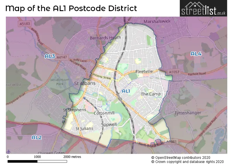
The AL1 Postcode shares a border with AL2 (LONDON COLNEY, BRICKET WOOD, PARK STREET), AL3 (ST. ALBANS, Redbourn, Markyate) and AL4 (ST. ALBANS, Wheathampstead, Sandridge).
The primary settlement in the AL1 postcode district is St. Albans, which is located in the county of Hertfordshire in England. St. Albans is the most significant settlement with the highest count, followed by other significant settlements in the AL1 district, including St. Albans as well.
For the district AL1, we have data on 6 postcode sectors. Here's a breakdown: The sector AL1 1, covers St. Albans in Hertfordshire. The sector AL1 2, covers St. Albans in Hertfordshire. The sector AL1 3, covers St. Albans in Hertfordshire. The sector AL1 4, covers St. Albans in Hertfordshire. The sector AL1 5, covers St. Albans in Hertfordshire. The sector AL1 9 is non-geographic. It's often designated for PO Boxes, large organisations, or special services.

Map of the AL1 Postcode District
Explore the AL1 postcode district by using our free interactive map.
When it comes to local government, postal geography often disregards political borders. However, for a breakdown in the AL1 District: the district mostly encompasses the St. Albans District (B) area with a total of 1215 postcodes.
Weather Forecast for AL1
Press Button to Show Forecast for St. Albans
| Time Period | Icon | Description | Temperature | Rain Probability | Wind |
|---|---|---|---|---|---|
| 09:00 to 12:00 | Overcast | 6.0°C (feels like 4.0°C) | 15.00% | NW 4 mph | |
| 12:00 to 15:00 | Overcast | 8.0°C (feels like 5.0°C) | 49.00% | NNW 9 mph | |
| 15:00 to 18:00 | Cloudy | 9.0°C (feels like 7.0°C) | 19.00% | N 9 mph | |
| 18:00 to 21:00 | Cloudy | 8.0°C (feels like 6.0°C) | 6.00% | NNE 11 mph | |
| 21:00 to 00:00 | Cloudy | 5.0°C (feels like 3.0°C) | 5.00% | N 4 mph |
Press Button to Show Forecast for St. Albans
| Time Period | Icon | Description | Temperature | Rain Probability | Wind |
|---|---|---|---|---|---|
| 00:00 to 03:00 | Cloudy | 5.0°C (feels like 2.0°C) | 5.00% | NW 7 mph | |
| 03:00 to 06:00 | Cloudy | 4.0°C (feels like 1.0°C) | 8.00% | NNW 9 mph | |
| 06:00 to 09:00 | Overcast | 4.0°C (feels like 1.0°C) | 9.00% | NNW 9 mph | |
| 09:00 to 12:00 | Overcast | 6.0°C (feels like 3.0°C) | 10.00% | NNW 11 mph | |
| 12:00 to 15:00 | Overcast | 8.0°C (feels like 5.0°C) | 10.00% | NNW 11 mph | |
| 15:00 to 18:00 | Cloudy | 8.0°C (feels like 6.0°C) | 8.00% | NNW 11 mph | |
| 18:00 to 21:00 | Cloudy | 7.0°C (feels like 5.0°C) | 6.00% | N 9 mph | |
| 21:00 to 00:00 | Partly cloudy (night) | 5.0°C (feels like 2.0°C) | 2.00% | N 7 mph |
Press Button to Show Forecast for St. Albans
| Time Period | Icon | Description | Temperature | Rain Probability | Wind |
|---|---|---|---|---|---|
| 00:00 to 03:00 | Clear night | 3.0°C (feels like 1.0°C) | 2.00% | N 7 mph | |
| 03:00 to 06:00 | Partly cloudy (night) | 3.0°C (feels like 0.0°C) | 2.00% | NW 7 mph | |
| 06:00 to 09:00 | Cloudy | 4.0°C (feels like 1.0°C) | 4.00% | NW 7 mph | |
| 09:00 to 12:00 | Cloudy | 7.0°C (feels like 4.0°C) | 7.00% | NNW 9 mph | |
| 12:00 to 15:00 | Overcast | 9.0°C (feels like 7.0°C) | 12.00% | NNW 9 mph | |
| 15:00 to 18:00 | Cloudy | 10.0°C (feels like 8.0°C) | 10.00% | NNW 9 mph | |
| 18:00 to 21:00 | Light rain shower (day) | 9.0°C (feels like 7.0°C) | 28.00% | NNW 7 mph | |
| 21:00 to 00:00 | Partly cloudy (night) | 6.0°C (feels like 4.0°C) | 4.00% | ENE 4 mph |
Press Button to Show Forecast for St. Albans
| Time Period | Icon | Description | Temperature | Rain Probability | Wind |
|---|---|---|---|---|---|
| 00:00 to 03:00 | Clear night | 4.0°C (feels like 2.0°C) | 2.00% | E 4 mph | |
| 03:00 to 06:00 | Partly cloudy (night) | 3.0°C (feels like 1.0°C) | 4.00% | ENE 4 mph | |
| 06:00 to 09:00 | Cloudy | 4.0°C (feels like 2.0°C) | 9.00% | E 4 mph | |
| 09:00 to 12:00 | Cloudy | 8.0°C (feels like 6.0°C) | 9.00% | ESE 7 mph | |
| 12:00 to 15:00 | Overcast | 10.0°C (feels like 9.0°C) | 16.00% | E 7 mph | |
| 15:00 to 18:00 | Cloudy | 10.0°C (feels like 9.0°C) | 13.00% | SE 7 mph | |
| 18:00 to 21:00 | Cloudy | 10.0°C (feels like 8.0°C) | 12.00% | ESE 7 mph | |
| 21:00 to 00:00 | Partly cloudy (night) | 7.0°C (feels like 6.0°C) | 7.00% | SSE 7 mph |
Where is the AL1 Postcode District?
The postcode district AL1 is located in the town of St. Albans. It is situated near the towns of Napsbury to the south, St. Albans to the southwest, and London Colney to the southeast. The district is approximately 18.5 miles away from the center of London.
The district covers the post towns of HARPENDEN, ST. ALBANS.
The sector has postcodes within the nation of England.
The AL1 Postcode District is in the Hertfordshire region of Bedfordshire and Hertfordshire within the East of England.
| Postcode Sector | Delivery Office |
|---|---|
| AL1 1 | St. Albans Delivery Office |
| AL1 2 | St. Albans Delivery Office |
| AL1 3 | St. Albans Delivery Office |
| AL1 4 | St. Albans Delivery Office |
| AL1 5 | St. Albans Delivery Office |
| A | L | 1 | - | X | X | X |
| A | L | 1 | Space | Numeric | Letter | Letter |
Current Monthly Rental Prices
| # Bedrooms | Min Price | Max Price | Avg Price |
|---|---|---|---|
| £663 | £1,025 | £896 | |
| 1 | £1,100 | £4,004 | £1,828 |
| 2 | £1,450 | £4,732 | £2,036 |
| 3 | £2,100 | £2,600 | £2,333 |
| 4 | £2,300 | £17,333 | £5,606 |
| 5 | £3,750 | £6,600 | £5,200 |
| 6 | £4,500 | £4,500 | £4,500 |
Current House Prices
| # Bedrooms | Min Price | Max Price | Avg Price |
|---|---|---|---|
| 3 | £1,350,000 | £1,400,000 | £1,366,667 |
| 4 | £1,350,000 | £1,700,000 | £1,492,857 |
| 5 | £1,350,000 | £5,950,000 | £2,082,500 |
| 6 | £1,625,000 | £3,000,000 | £2,206,250 |
| 7 | £3,000,000 | £3,000,000 | £3,000,000 |
Estate Agents who Operate in the AL1 District
| Logo | Name | Brand Name | Address | Contact Number | Total Properties |
|---|---|---|---|---|---|
 | St. Albans | Frost's Estate Agents | 4 Chequer Street, St. Albans, AL1 3XZ | 01727 649757 | 47 |
 | St. Albans | Bradford & Howley | 8 Chequer Street, St. Albans, Herts AL1 3XZ | 01727 222275 | 25 |
 | St Albans | Connells | 38 Chequer Street, St Albans, Hertfordshire, AL1 3YH | 01727 222284 | 23 |
 | St Albans | Paul Barker Estate Agents | Longmire House, 36-38 London Road, St Albans, AL1 1NG | 01727 222064 | 22 |
 | St Albans | Collinson Hall | 9 - 11 Victoria Street, St. Albans, Hertfordshire, AL1 3UB | 01727 649409 | 22 |
| Type of Property | 2018 Average | 2018 Sales | 2017 Average | 2017 Sales | 2016 Average | 2016 Sales | 2015 Average | 2015 Sales |
|---|---|---|---|---|---|---|---|---|
| Detached | £1,096,465 | 77 | £1,144,060 | 81 | £1,094,605 | 96 | £955,856 | 92 |
| Semi-Detached | £695,057 | 127 | £672,631 | 118 | £687,466 | 128 | £593,604 | 123 |
| Terraced | £554,398 | 193 | £534,898 | 197 | £527,264 | 209 | £439,206 | 232 |
| Flats | £364,741 | 310 | £367,313 | 303 | £340,032 | 322 | £295,201 | 374 |