The AL2 postcode district is a postal district located in the AL St Albans postcode area with a population of 24,211 residents according to the 2021 England and Wales Census.
The area of the AL2 postcode district is 10.53 square miles which is 27.27 square kilometres or 6,738.23 acres.
Currently, the AL2 district has about 724 postcode units spread across 3 geographic postcode sectors.
Given that each sector allows for 400 unique postcode combinations, the district has a capacity of 1,200 postcodes. With 724 postcodes already in use, this leaves 476 units available.
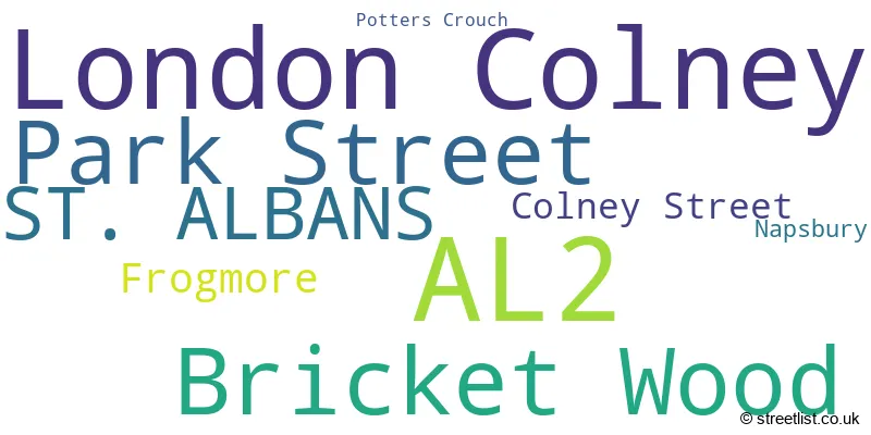
The largest settlement in the AL2 postal code is LONDON COLNEY followed by BRICKET WOOD, and PARK STREET.
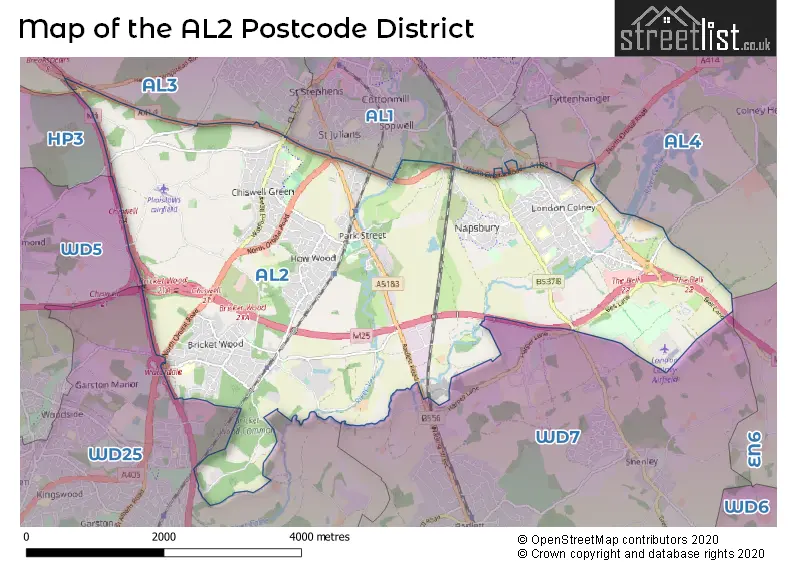
The AL2 Postcode shares a border with AL1 (ST. ALBANS), AL3 (ST. ALBANS, Redbourn, Markyate), AL4 (ST. ALBANS, Wheathampstead, Sandridge), WD25 (WATFORD) and WD7 (RADLETT, SHENLEY).
In the AL2 postcode district, the primary settlement is St. Albans, located in the county of Hertfordshire, England. Other significant settlements in this district include London Colney, Napsbury, Colney Street, Frogmore, Park Street, and Bricket Wood, all located in the same county. The most significant post town in this district is St. Albans.
For the district AL2, we have data on 3 postcode sectors. Here's a breakdown: The sector AL2 1, covers London Colney in Hertfordshire. The sector AL2 2, covers Park Street and St. Albans in Hertfordshire. The sector AL2 3, covers Bricket Wood and St. Albans in Hertfordshire.

Map of the AL2 Postcode District
Explore the AL2 postcode district by using our free interactive map.
When it comes to local government, postal geography often disregards political borders. However, for a breakdown in the AL2 District: the district mostly encompasses the St. Albans District (B) (718 postcodes), and finally, the Hertsmere District (B) area (11 postcodes).
Weather Forecast for AL2
Press Button to Show Forecast for Chiswell Green
| Time Period | Icon | Description | Temperature | Rain Probability | Wind |
|---|---|---|---|---|---|
| 09:00 to 12:00 | Cloudy | 10.0°C (feels like 7.0°C) | 15.00% | NW 16 mph | |
| 12:00 to 15:00 | Cloudy | 11.0°C (feels like 8.0°C) | 31.00% | NNW 16 mph | |
| 15:00 to 18:00 | Cloudy | 11.0°C (feels like 8.0°C) | 13.00% | N 13 mph | |
| 18:00 to 21:00 | Cloudy | 9.0°C (feels like 7.0°C) | 45.00% | N 9 mph | |
| 21:00 to 00:00 | Cloudy | 7.0°C (feels like 5.0°C) | 6.00% | NNE 7 mph |
Press Button to Show Forecast for Chiswell Green
| Time Period | Icon | Description | Temperature | Rain Probability | Wind |
|---|---|---|---|---|---|
| 00:00 to 03:00 | Cloudy | 5.0°C (feels like 2.0°C) | 4.00% | N 9 mph | |
| 03:00 to 06:00 | Clear night | 4.0°C (feels like 1.0°C) | 1.00% | NNW 9 mph | |
| 06:00 to 09:00 | Partly cloudy (day) | 4.0°C (feels like 0.0°C) | 2.00% | NNW 9 mph | |
| 09:00 to 12:00 | Overcast | 7.0°C (feels like 3.0°C) | 8.00% | N 11 mph | |
| 12:00 to 15:00 | Overcast | 8.0°C (feels like 6.0°C) | 9.00% | N 11 mph | |
| 15:00 to 18:00 | Overcast | 9.0°C (feels like 7.0°C) | 9.00% | N 11 mph | |
| 18:00 to 21:00 | Cloudy | 9.0°C (feels like 6.0°C) | 5.00% | NNE 9 mph | |
| 21:00 to 00:00 | Clear night | 6.0°C (feels like 4.0°C) | 2.00% | NNE 7 mph |
Press Button to Show Forecast for Chiswell Green
| Time Period | Icon | Description | Temperature | Rain Probability | Wind |
|---|---|---|---|---|---|
| 00:00 to 03:00 | Clear night | 4.0°C (feels like 2.0°C) | 1.00% | N 4 mph | |
| 03:00 to 06:00 | Partly cloudy (night) | 4.0°C (feels like 1.0°C) | 1.00% | NNW 7 mph | |
| 06:00 to 09:00 | Partly cloudy (day) | 4.0°C (feels like 2.0°C) | 4.00% | N 7 mph | |
| 09:00 to 12:00 | Cloudy | 7.0°C (feels like 5.0°C) | 8.00% | NNE 9 mph | |
| 12:00 to 15:00 | Overcast | 9.0°C (feels like 7.0°C) | 10.00% | NNE 9 mph | |
| 15:00 to 18:00 | Cloudy | 10.0°C (feels like 8.0°C) | 8.00% | NNE 11 mph | |
| 18:00 to 21:00 | Cloudy | 9.0°C (feels like 7.0°C) | 5.00% | NNE 11 mph | |
| 21:00 to 00:00 | Clear night | 7.0°C (feels like 4.0°C) | 3.00% | NNE 9 mph |
Press Button to Show Forecast for Chiswell Green
| Time Period | Icon | Description | Temperature | Rain Probability | Wind |
|---|---|---|---|---|---|
| 00:00 to 03:00 | Clear night | 5.0°C (feels like 2.0°C) | 3.00% | NNE 7 mph | |
| 03:00 to 06:00 | Clear night | 4.0°C (feels like 1.0°C) | 2.00% | NNE 7 mph | |
| 06:00 to 09:00 | Partly cloudy (day) | 5.0°C (feels like 2.0°C) | 3.00% | N 7 mph | |
| 09:00 to 12:00 | Partly cloudy (day) | 8.0°C (feels like 5.0°C) | 3.00% | NNE 11 mph | |
| 12:00 to 15:00 | Cloudy | 10.0°C (feels like 8.0°C) | 8.00% | NE 11 mph | |
| 15:00 to 18:00 | Light rain shower (day) | 10.0°C (feels like 8.0°C) | 26.00% | NNE 11 mph | |
| 18:00 to 21:00 | Cloudy | 9.0°C (feels like 7.0°C) | 8.00% | NNE 11 mph | |
| 21:00 to 00:00 | Clear night | 7.0°C (feels like 4.0°C) | 4.00% | NNE 9 mph |
Where is the AL2 Postcode District?
The AL2 postcode district is located in St. Albans. St. Albans is a district town in close proximity to several nearby towns. To the South East of St. Albans is Frogmore, which is approximately 0.37 miles away. To the North West is Park Street, which is approximately 0.41 miles away. To the North East is Napsbury, which is approximately 1.14 miles away. To the South West is Bricket Wood, which is approximately 1.44 miles away. Additionally, St. Albans is located approximately 17.10 miles away from the center of London.
The district is within the post town of ST. ALBANS.
The sector has postcodes within the nation of England.
The AL2 Postcode District is in the Hertfordshire region of Bedfordshire and Hertfordshire within the East of England.
| Postcode Sector | Delivery Office |
|---|---|
| AL2 1 | St. Albans Delivery Office |
| AL2 2 | St. Albans Delivery Office |
| AL2 3 | St. Albans Delivery Office |
| A | L | 2 | - | X | X | X |
| A | L | 2 | Space | Numeric | Letter | Letter |
Tourist Attractions within the Postcode Area
We found 1 visitor attractions within the AL2 postcode area
| de Havilland Aircraft Heritage Centre |
|---|
| Museums & Art Galleries |
| Museum and / or Art Gallery |
| View de Havilland Aircraft Heritage Centre on Google Maps |
Current Monthly Rental Prices
| # Bedrooms | Min Price | Max Price | Avg Price |
|---|---|---|---|
| £750 | £875 | £775 | |
| 1 | £875 | £1,400 | £1,154 |
| 2 | £1,450 | £2,100 | £1,725 |
| 3 | £1,400 | £2,750 | £1,967 |
| 4 | £3,250 | £3,250 | £3,250 |
Current House Prices
| # Bedrooms | Min Price | Max Price | Avg Price |
|---|---|---|---|
| 3 | £1,000,000 | £1,725,000 | £1,483,333 |
| 4 | £1,000,000 | £3,000,000 | £1,466,667 |
| 5 | £950,000 | £1,750,000 | £1,348,635 |
| 6 | £950,000 | £950,000 | £950,000 |
| 7 | £1,600,000 | £1,600,000 | £1,600,000 |
Estate Agents who Operate in the AL2 District
| Logo | Name | Brand Name | Address | Contact Number | Total Properties |
|---|---|---|---|---|---|
 | St. Albans | Frost's Estate Agents | 4 Chequer Street, St. Albans, AL1 3XZ | 01727 649757 | 18 |
 | Park Street | JW&Co | 6 How Wood, Park Street, St. Albans, AL2 2RA | 01727 221889 | 17 |
 | Bricket Wood | Carter Hayward | 119 Oakwood Road, Bricket Wood, AL2 3QB | 01923 961360 | 16 |
 | St Albans | Collinson Hall | 9 - 11 Victoria Street, St. Albans, Hertfordshire, AL1 3UB | 01727 649409 | 15 |
 | Marshalswick | Frost's Estate Agents | 61 The Quadrant, St. Albans, AL4 9RF | 01727 221786 | 13 |
| Type of Property | 2018 Average | 2018 Sales | 2017 Average | 2017 Sales | 2016 Average | 2016 Sales | 2015 Average | 2015 Sales |
|---|---|---|---|---|---|---|---|---|
| Detached | £645,992 | 85 | £710,290 | 88 | £638,586 | 98 | £632,278 | 112 |
| Semi-Detached | £517,550 | 92 | £521,072 | 69 | £507,786 | 80 | £465,982 | 118 |
| Terraced | £461,030 | 81 | £441,732 | 75 | £429,648 | 86 | £358,173 | 96 |
| Flats | £272,429 | 71 | £266,872 | 67 | £274,693 | 114 | £238,287 | 120 |
Hotels within the Postcode Area
We found 5 hotels and guest houses within the AL2 postcode area
Premier Inn St. Albans/Bricket Wood
Smug Oak Lane, Watling Street, Bricket Wood, saint-albans, AL2 3PN.
View detailsHoliday Inn Express St. Albans - M25, Jct.22
Colney Field Retail Park, St. Albans, saint-albans, AL2 1AB.
View detailsInnkeeper's Lodge St Albans, London Colney
The Colney Fox Vintage Inn, Barnet Road, London Colney, St Albans, london-colney, AL2 1BL.
View details