The B20 postcode district is a postal district located in the B Birmingham postcode area with a population of 37,142 residents according to the 2021 England and Wales Census.
The area of the B20 postcode district is 2.63 square miles which is 6.82 square kilometres or 1,684.78 acres.
Currently, the B20 district has about 530 postcode units spread across 3 geographic postcode sectors.
Given that each sector allows for 400 unique postcode combinations, the district has a capacity of 1,200 postcodes. With 530 postcodes already in use, this leaves 670 units available.
The largest settlements in the B20 postal code are BIRMINGHAM and Handsworth.
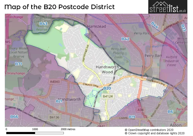
The B20 Postcode shares a border with B21 (BIRMINGHAM, Handsworth), B19 (BIRMINGHAM, Lozells, Handsworth), B42 (BIRMINGHAM, Perry Barr, Great Barr), B6 (BIRMINGHAM, Aston, Witton), B43 (BIRMINGHAM, Great Barr) and B71 (WEST BROMWICH).
The primary settlement in the B20 postcode district is Handsworth, located in Birmingham, West Midlands. Other significant settlements in the district include Birmingham itself. The primary post town in the district is Birmingham, also located in the West Midlands county.
For the district B20, we have data on 3 postcode sectors. Here's a breakdown: The sector B20 1, covers Birmingham in West Midlands. The sector B20 2, covers Birmingham and Handsworth in West Midlands. The sector B20 3, covers Birmingham and Handsworth in West Midlands.

Map of the B20 Postcode District
Explore the B20 postcode district by using our free interactive map.
When it comes to local government, postal geography often disregards political borders. However, for a breakdown in the B20 District: the district mostly encompasses the Birmingham District (B) area with a total of 534 postcodes.
Weather Forecast for B20
Press Button to Show Forecast for Brown's Green
| Time Period | Icon | Description | Temperature | Rain Probability | Wind |
|---|---|---|---|---|---|
| 00:00 to 03:00 | Light rain | 9.0°C (feels like 6.0°C) | 50.00% | WNW 13 mph | |
| 03:00 to 06:00 | Light rain | 9.0°C (feels like 6.0°C) | 55.00% | WNW 13 mph | |
| 06:00 to 09:00 | Cloudy | 8.0°C (feels like 5.0°C) | 46.00% | NW 11 mph | |
| 09:00 to 12:00 | Cloudy | 9.0°C (feels like 6.0°C) | 39.00% | NW 16 mph | |
| 12:00 to 15:00 | Cloudy | 11.0°C (feels like 8.0°C) | 8.00% | NNW 18 mph | |
| 15:00 to 18:00 | Overcast | 11.0°C (feels like 8.0°C) | 9.00% | NNW 16 mph | |
| 18:00 to 21:00 | Light rain shower (day) | 9.0°C (feels like 7.0°C) | 36.00% | NNW 13 mph | |
| 21:00 to 00:00 | Cloudy | 7.0°C (feels like 6.0°C) | 47.00% | N 7 mph |
Press Button to Show Forecast for Brown's Green
| Time Period | Icon | Description | Temperature | Rain Probability | Wind |
|---|---|---|---|---|---|
| 00:00 to 03:00 | Cloudy | 6.0°C (feels like 4.0°C) | 7.00% | NNE 4 mph | |
| 03:00 to 06:00 | Cloudy | 4.0°C (feels like 2.0°C) | 5.00% | NNE 4 mph | |
| 06:00 to 09:00 | Cloudy | 4.0°C (feels like 2.0°C) | 5.00% | N 4 mph | |
| 09:00 to 12:00 | Sunny day | 7.0°C (feels like 4.0°C) | 2.00% | N 7 mph | |
| 12:00 to 15:00 | Overcast | 10.0°C (feels like 8.0°C) | 8.00% | N 7 mph | |
| 15:00 to 18:00 | Overcast | 10.0°C (feels like 9.0°C) | 8.00% | NNE 7 mph | |
| 18:00 to 21:00 | Partly cloudy (day) | 10.0°C (feels like 8.0°C) | 3.00% | NNE 7 mph | |
| 21:00 to 00:00 | Partly cloudy (night) | 7.0°C (feels like 6.0°C) | 2.00% | NNE 4 mph |
Press Button to Show Forecast for Brown's Green
| Time Period | Icon | Description | Temperature | Rain Probability | Wind |
|---|---|---|---|---|---|
| 00:00 to 03:00 | Clear night | 6.0°C (feels like 4.0°C) | 1.00% | NE 4 mph | |
| 03:00 to 06:00 | Partly cloudy (night) | 4.0°C (feels like 3.0°C) | 1.00% | N 2 mph | |
| 06:00 to 09:00 | Cloudy | 5.0°C (feels like 3.0°C) | 4.00% | N 4 mph | |
| 09:00 to 12:00 | Cloudy | 8.0°C (feels like 6.0°C) | 5.00% | NNE 4 mph | |
| 12:00 to 15:00 | Overcast | 10.0°C (feels like 8.0°C) | 9.00% | NNE 7 mph | |
| 15:00 to 18:00 | Overcast | 11.0°C (feels like 9.0°C) | 11.00% | NNE 7 mph | |
| 18:00 to 21:00 | Cloudy | 10.0°C (feels like 8.0°C) | 5.00% | NE 9 mph | |
| 21:00 to 00:00 | Partly cloudy (night) | 8.0°C (feels like 5.0°C) | 4.00% | NE 9 mph |
Press Button to Show Forecast for Brown's Green
| Time Period | Icon | Description | Temperature | Rain Probability | Wind |
|---|---|---|---|---|---|
| 00:00 to 03:00 | Cloudy | 6.0°C (feels like 3.0°C) | 6.00% | ENE 7 mph | |
| 03:00 to 06:00 | Clear night | 5.0°C (feels like 2.0°C) | 3.00% | NNE 7 mph | |
| 06:00 to 09:00 | Sunny day | 5.0°C (feels like 2.0°C) | 4.00% | NNE 7 mph | |
| 09:00 to 12:00 | Partly cloudy (day) | 8.0°C (feels like 5.0°C) | 5.00% | NE 9 mph | |
| 12:00 to 15:00 | Overcast | 10.0°C (feels like 8.0°C) | 10.00% | NE 9 mph | |
| 15:00 to 18:00 | Overcast | 11.0°C (feels like 8.0°C) | 10.00% | NE 11 mph | |
| 18:00 to 21:00 | Partly cloudy (day) | 10.0°C (feels like 7.0°C) | 6.00% | NE 9 mph | |
| 21:00 to 00:00 | Cloudy | 7.0°C (feels like 5.0°C) | 8.00% | NE 7 mph |
Where is the B20 Postcode District?
The postcode district B20 is located in the town of Birmingham, which is in the West Midlands region of the United Kingdom. Birmingham is surrounded by several nearby towns, including West Bromwich to the west, Smethwick to the southwest, Wednesbury to the northwest, Sutton Coldfield to the northeast, and Walsall to the north. The distance from B20 to London, the capital city of the UK, is approximately 103.76 miles.
The district is within the post town of BIRMINGHAM.
The sector has postcodes within the nation of England.
The B20 Postcode District is in the Birmingham region of West Midlands within the West Midlands (England).
| Postcode Sector | Delivery Office |
|---|---|
| B20 1 | Handsworth Delivery Office |
| B20 2 | Handsworth Delivery Office |
| B20 3 | Handsworth Delivery Office |
| B | 2 | 0 | - | X | X | X |
| B | 2 | 0 | Space | Numeric | Letter | Letter |
Current Monthly Rental Prices
| # Bedrooms | Min Price | Max Price | Avg Price |
|---|---|---|---|
| £500 | £575 | £538 | |
| 1 | £74 | £650 | £189 |
| 2 | £795 | £900 | £855 |
| 3 | £1,000 | £1,400 | £1,208 |
| 6 | £74 | £74 | £74 |
Current House Prices
| # Bedrooms | Min Price | Max Price | Avg Price |
|---|---|---|---|
| 4 | £450,000 | £800,000 | £537,217 |
| 5 | £449,950 | £875,000 | £573,831 |
| 6 | £650,000 | £650,000 | £650,000 |
| 7 | £550,000 | £550,000 | £550,000 |
| 9 | £675,000 | £675,000 | £675,000 |
Estate Agents who Operate in the B20 District
| Logo | Name | Brand Name | Address | Contact Number | Total Properties |
|---|---|---|---|---|---|
 | Hamstead | Paul Carr | 3 International House, Old Walsall Road, Great Barr, Birmingham, B42 1NN | 0121 387 6411 | 19 |
 | Great Barr | Connells | 907 Walsall Road, Great Barr, B42 1TN | 0121 387 6334 | 19 |
 | Handsworth | Hunters | 304 Rookery Road, Handsworth, Birmingham, B21 9QG | 0121 387 6455 | 15 |
 | Great Barr | Shipways | 905 Walsall Road, Great Barr, B42 1TN | 0121 387 6303 | 12 |
 | Covering West Midlands | Homewise | B46 1DL | 01273 092409 | 11 |
| Type of Property | 2018 Average | 2018 Sales | 2017 Average | 2017 Sales | 2016 Average | 2016 Sales | 2015 Average | 2015 Sales |
|---|---|---|---|---|---|---|---|---|
| Detached | £297,984 | 35 | £256,257 | 33 | £252,858 | 46 | £258,124 | 46 |
| Semi-Detached | £209,608 | 76 | £203,272 | 69 | £175,208 | 92 | £169,367 | 76 |
| Terraced | £145,123 | 124 | £144,382 | 108 | £140,140 | 99 | £122,584 | 98 |
| Flats | £79,788 | 20 | £66,378 | 25 | £71,971 | 25 | £63,878 | 27 |