The B25 postcode district is a postal district located in the B Birmingham postcode area with a population of 18,043 residents according to the 2021 England and Wales Census.
The area of the B25 postcode district is 1.22 square miles which is 3.15 square kilometres or 779.01 acres.
Currently, the B25 district has about 270 postcode units spread across 1 geographic postcode sectors.
Given that each sector allows for 400 unique postcode combinations, the district has a capacity of 400 postcodes. With 270 postcodes already in use, this leaves 130 units available.
The largest settlements in the B25 postal code are BIRMINGHAM and Yardley.
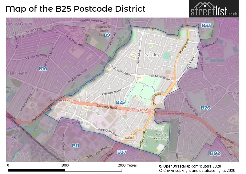
The B25 Postcode shares a border with B26 (BIRMINGHAM, Sheldon, Yardley), B33 (BIRMINGHAM, Stechford, Kitts Green), B11 (BIRMINGHAM, Sparkhill, Tyseley), B9 (BIRMINGHAM, Bordesley Green, Small Heath), B10 (BIRMINGHAM, Small Heath) and B27 (BIRMINGHAM, Acocks Green).
The primary settlement in the B25 postcode district is Birmingham in the county of West Midlands. Yardley is another significant settlement in the district. Both settlements are part of the post town of Birmingham in the county of West Midlands.
For the district B25, we have data on 2 postcode sectors. Here's a breakdown: The sector B25 8, covers Birmingham and Yardley in West Midlands. The sector B25 9 is non-geographic. It's often designated for PO Boxes, large organisations, or special services.
B25 Postcode Sectors

Map of the B25 Postcode District
Explore the B25 postcode district by using our free interactive map.
When it comes to local government, postal geography often disregards political borders. However, for a breakdown in the B25 District: the district mostly encompasses the Birmingham District (B) area with a total of 281 postcodes.
Weather Forecast for B25
Press Button to Show Forecast for Hay Mills
| Time Period | Icon | Description | Temperature | Rain Probability | Wind |
|---|---|---|---|---|---|
| 00:00 to 03:00 | Partly cloudy (night) | 6.0°C (feels like 4.0°C) | 0.00% | NW 4 mph | |
| 03:00 to 06:00 | Cloudy | 5.0°C (feels like 3.0°C) | 4.00% | W 4 mph | |
| 06:00 to 09:00 | Overcast | 5.0°C (feels like 3.0°C) | 9.00% | WSW 4 mph | |
| 09:00 to 12:00 | Cloudy | 7.0°C (feels like 5.0°C) | 12.00% | WNW 9 mph | |
| 12:00 to 15:00 | Cloudy | 9.0°C (feels like 6.0°C) | 11.00% | NW 11 mph | |
| 15:00 to 18:00 | Cloudy | 9.0°C (feels like 7.0°C) | 10.00% | N 7 mph | |
| 18:00 to 21:00 | Cloudy | 9.0°C (feels like 7.0°C) | 8.00% | NE 4 mph | |
| 21:00 to 00:00 | Cloudy | 7.0°C (feels like 6.0°C) | 4.00% | ENE 4 mph |
Press Button to Show Forecast for Hay Mills
| Time Period | Icon | Description | Temperature | Rain Probability | Wind |
|---|---|---|---|---|---|
| 00:00 to 03:00 | Cloudy | 6.0°C (feels like 3.0°C) | 9.00% | E 7 mph | |
| 03:00 to 06:00 | Cloudy | 4.0°C (feels like 2.0°C) | 6.00% | ENE 4 mph | |
| 06:00 to 09:00 | Cloudy | 4.0°C (feels like 2.0°C) | 5.00% | ENE 4 mph | |
| 09:00 to 12:00 | Cloudy | 6.0°C (feels like 4.0°C) | 5.00% | ENE 7 mph | |
| 12:00 to 15:00 | Overcast | 9.0°C (feels like 7.0°C) | 11.00% | ENE 7 mph | |
| 15:00 to 18:00 | Overcast | 9.0°C (feels like 8.0°C) | 13.00% | ENE 7 mph | |
| 18:00 to 21:00 | Cloudy | 9.0°C (feels like 7.0°C) | 10.00% | ENE 7 mph | |
| 21:00 to 00:00 | Cloudy | 7.0°C (feels like 4.0°C) | 12.00% | E 7 mph |
Press Button to Show Forecast for Hay Mills
| Time Period | Icon | Description | Temperature | Rain Probability | Wind |
|---|---|---|---|---|---|
| 00:00 to 03:00 | Cloudy | 5.0°C (feels like 3.0°C) | 12.00% | ENE 7 mph | |
| 03:00 to 06:00 | Cloudy | 4.0°C (feels like 2.0°C) | 13.00% | ENE 7 mph | |
| 06:00 to 09:00 | Cloudy | 5.0°C (feels like 2.0°C) | 14.00% | ENE 7 mph | |
| 09:00 to 12:00 | Cloudy | 7.0°C (feels like 4.0°C) | 19.00% | ENE 9 mph | |
| 12:00 to 15:00 | Light rain | 9.0°C (feels like 6.0°C) | 53.00% | ENE 9 mph | |
| 15:00 to 18:00 | Overcast | 10.0°C (feels like 8.0°C) | 23.00% | ENE 9 mph | |
| 18:00 to 21:00 | Cloudy | 10.0°C (feels like 7.0°C) | 19.00% | ENE 9 mph | |
| 21:00 to 00:00 | Overcast | 8.0°C (feels like 5.0°C) | 24.00% | NE 11 mph |
Press Button to Show Forecast for Hay Mills
| Time Period | Icon | Description | Temperature | Rain Probability | Wind |
|---|---|---|---|---|---|
| 00:00 to 03:00 | Light rain | 7.0°C (feels like 4.0°C) | 52.00% | NE 9 mph | |
| 03:00 to 06:00 | Heavy rain | 7.0°C (feels like 4.0°C) | 70.00% | NE 9 mph | |
| 06:00 to 09:00 | Heavy rain | 7.0°C (feels like 4.0°C) | 73.00% | NNE 9 mph | |
| 09:00 to 12:00 | Heavy rain | 8.0°C (feels like 6.0°C) | 75.00% | NNE 9 mph | |
| 12:00 to 15:00 | Light rain shower (day) | 10.0°C (feels like 8.0°C) | 43.00% | NNE 9 mph | |
| 15:00 to 18:00 | Heavy rain shower (day) | 11.0°C (feels like 9.0°C) | 59.00% | NW 9 mph | |
| 18:00 to 21:00 | Heavy rain shower (day) | 11.0°C (feels like 9.0°C) | 55.00% | NNW 9 mph | |
| 21:00 to 00:00 | Partly cloudy (night) | 9.0°C (feels like 7.0°C) | 10.00% | WNW 7 mph |
Where is the B25 Postcode District?
The B25 postcode district is located in BIRMINGHAM. It is nearby the towns of SOLIHULL, SMETHWICK, SUTTON COLDFIELD, and WEST BROMWICH. The distance from the B25 district to London is approximately 98.01 miles.
The district is within the post town of BIRMINGHAM.
The sector has postcodes within the nation of England.
The B25 Postcode District is in the Birmingham region of West Midlands within the West Midlands (England).
Postcode Sectors within the B25 District
| Postcode Sector | Delivery Office |
|---|---|
| B25 8 | Redfern Park Delivery Office |
| B | 2 | 5 | - | X | X | X |
| B | 2 | 5 | Space | Numeric | Letter | Letter |
Tourist Attractions within the Postcode Area
We found 1 visitor attractions within the B25 postcode area
| Blakesley Hall |
|---|
| Historic Properties |
| Historic House / House and Garden / Palace |
| View Blakesley Hall on Google Maps |
Current Monthly Rental Prices
| # Bedrooms | Min Price | Max Price | Avg Price |
|---|---|---|---|
| 1 | £775 | £775 | £775 |
| 2 | £750 | £925 | £838 |
| 4 | £995 | £995 | £995 |
Current House Prices
| # Bedrooms | Min Price | Max Price | Avg Price |
|---|---|---|---|
| 2 | £180,000 | £250,000 | £208,990 |
| 3 | £175,000 | £300,000 | £224,188 |
| 4 | £240,000 | £240,000 | £240,000 |
| 5 | £325,000 | £335,000 | £330,000 |
| 6 | £299,999 | £299,999 | £299,999 |
Estate Agents who Operate in the B25 District
| Logo | Name | Brand Name | Address | Contact Number | Total Properties |
|---|---|---|---|---|---|
 | Sheldon | Burchell Edwards | 2208 Coventry Road, Sheldon, Birmingham, B26 3JH | 0121 387 6431 | 8 |
 | Yardley | Dixons | 110 Church Road, Yardley, Birmingham, West Midlands, B25 8UX | 0121 387 6293 | 6 |
 | Yardley | Prime Estates | 167-169 Church Road, Yardley, Birmingham, B25 8UR | 0121 387 6377 | 3 |
 | Birmingham | Centrick | The Exchange, 19 Newhall Street, Birmingham B3 3PJ | 0121 387 6473 | 3 |
 | Yardley | Reeds Rains | 124 Church Road, Yardley, Birmingham, B25 8UT | 0121 387 6498 | 2 |
| Type of Property | 2018 Average | 2018 Sales | 2017 Average | 2017 Sales | 2016 Average | 2016 Sales | 2015 Average | 2015 Sales |
|---|---|---|---|---|---|---|---|---|
| Detached | £285,938 | 8 | £216,500 | 3 | £259,714 | 14 | £228,563 | 8 |
| Semi-Detached | £167,599 | 53 | £169,986 | 48 | £155,173 | 40 | £157,357 | 57 |
| Terraced | £133,864 | 104 | £127,295 | 116 | £120,513 | 110 | £116,957 | 131 |
| Flats | £87,367 | 15 | £88,024 | 21 | £80,727 | 11 | £73,333 | 9 |