The B45 postcode district is a postal district located in the B Birmingham postcode area with a population of 32,452 residents according to the 2021 England and Wales Census.
The area of the B45 postcode district is 8.18 square miles which is 21.19 square kilometres or 5,234.93 acres.
Currently, the B45 district has about 701 postcode units spread across 3 geographic postcode sectors.
Given that each sector allows for 400 unique postcode combinations, the district has a capacity of 1,200 postcodes. With 701 postcodes already in use, this leaves 499 units available.
The largest settlement in the B45 postal code is Rednal followed by Barnt Green, and Cofton Hackett.
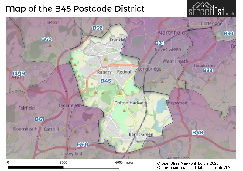
The B45 Postcode shares a border with B60 (BROMSGROVE, Stoke Prior, Marlbrook), B31 (BIRMINGHAM, Northfield), B32 (BIRMINGHAM, Quinton, Harborne) and B48 (Alvechurch, Portway).
The primary settlement in the B45 postcode district is Rednal, which is located in the county of Worcestershire in the West Midlands region of England. Other significant settlements in the district include Barnt Green, Cofton Hackett, and Lickey. The post town for this district is Birmingham.
For the district B45, we have data on 4 postcode sectors. Here's a breakdown: The sector B45 0, covers Rednal in West Midlands. The sector B45 5 is non-geographic. It's often designated for PO Boxes, large organisations, or special services. The sector B45 8, covers Barnt Green and Cofton Hackett in Worcestershire. The sector B45 8, covers Rednal in West Midlands. The sector B45 9, covers Rednal in Worcestershire. The sector B45 9, covers Rednal in West Midlands.

Map of the B45 Postcode District
Explore the B45 postcode district by using our free interactive map.
When it comes to local government, postal geography often disregards political borders. However, for a breakdown in the B45 District: the district mostly encompasses the Birmingham District (B) (373 postcodes), and finally, the Bromsgrove District area (334 postcodes).
Weather Forecast for B45
Press Button to Show Forecast for Rednal
| Time Period | Icon | Description | Temperature | Rain Probability | Wind |
|---|---|---|---|---|---|
| 21:00 to 00:00 | Cloudy | 7.0°C (feels like 5.0°C) | 4.00% | ENE 4 mph |
Press Button to Show Forecast for Rednal
| Time Period | Icon | Description | Temperature | Rain Probability | Wind |
|---|---|---|---|---|---|
| 00:00 to 03:00 | Cloudy | 5.0°C (feels like 3.0°C) | 7.00% | E 7 mph | |
| 03:00 to 06:00 | Cloudy | 4.0°C (feels like 2.0°C) | 7.00% | E 7 mph | |
| 06:00 to 09:00 | Cloudy | 4.0°C (feels like 1.0°C) | 6.00% | ENE 7 mph | |
| 09:00 to 12:00 | Cloudy | 6.0°C (feels like 3.0°C) | 6.00% | E 7 mph | |
| 12:00 to 15:00 | Overcast | 8.0°C (feels like 6.0°C) | 12.00% | ENE 7 mph | |
| 15:00 to 18:00 | Cloudy | 9.0°C (feels like 8.0°C) | 9.00% | ENE 7 mph | |
| 18:00 to 21:00 | Cloudy | 8.0°C (feels like 7.0°C) | 10.00% | E 7 mph | |
| 21:00 to 00:00 | Cloudy | 6.0°C (feels like 4.0°C) | 12.00% | ENE 9 mph |
Press Button to Show Forecast for Rednal
| Time Period | Icon | Description | Temperature | Rain Probability | Wind |
|---|---|---|---|---|---|
| 00:00 to 03:00 | Cloudy | 5.0°C (feels like 2.0°C) | 11.00% | ENE 9 mph | |
| 03:00 to 06:00 | Cloudy | 4.0°C (feels like 1.0°C) | 12.00% | ENE 9 mph | |
| 06:00 to 09:00 | Cloudy | 4.0°C (feels like 1.0°C) | 13.00% | ENE 9 mph | |
| 09:00 to 12:00 | Cloudy | 6.0°C (feels like 3.0°C) | 17.00% | ENE 11 mph | |
| 12:00 to 15:00 | Light rain | 8.0°C (feels like 5.0°C) | 50.00% | ENE 11 mph | |
| 15:00 to 18:00 | Overcast | 9.0°C (feels like 7.0°C) | 23.00% | ENE 11 mph | |
| 18:00 to 21:00 | Cloudy | 9.0°C (feels like 6.0°C) | 18.00% | ENE 11 mph | |
| 21:00 to 00:00 | Cloudy | 7.0°C (feels like 4.0°C) | 22.00% | NE 11 mph |
Press Button to Show Forecast for Rednal
| Time Period | Icon | Description | Temperature | Rain Probability | Wind |
|---|---|---|---|---|---|
| 00:00 to 03:00 | Light rain | 6.0°C (feels like 3.0°C) | 52.00% | NE 11 mph | |
| 03:00 to 06:00 | Heavy rain | 6.0°C (feels like 3.0°C) | 71.00% | NE 11 mph | |
| 06:00 to 09:00 | Heavy rain | 6.0°C (feels like 3.0°C) | 76.00% | NE 11 mph | |
| 09:00 to 12:00 | Heavy rain | 8.0°C (feels like 5.0°C) | 76.00% | NNE 11 mph | |
| 12:00 to 15:00 | Light rain | 9.0°C (feels like 7.0°C) | 53.00% | ENE 11 mph | |
| 15:00 to 18:00 | Heavy rain shower (day) | 10.0°C (feels like 8.0°C) | 60.00% | NNW 11 mph | |
| 18:00 to 21:00 | Light rain shower (day) | 10.0°C (feels like 8.0°C) | 40.00% | NNE 9 mph | |
| 21:00 to 00:00 | Partly cloudy (night) | 8.0°C (feels like 5.0°C) | 10.00% | N 9 mph |
Where is the B45 Postcode District?
The postcode district B45 is located in Birmingham. It is situated near several nearby towns. To the South West, there is Bromsgrove, which is approximately 3.5 miles away. Halesowen is located to the North West, at a distance of about 4.8 miles. Redditch lies to the South East, approximately 6 miles away. Rowley Regis is situated to the North, about 7.2 miles away. Solihull is located to the North East, at a distance of around 8.4 miles. Additionally, the B45 postcode district is approximately 100.5 miles away from the centre of London.
The district is within the post town of BIRMINGHAM.
The sector has postcodes within the nation of England.
The B45 Postcode District is covers the following regions.
- Birmingham - West Midlands - West Midlands (England)
- Worcestershire - Herefordshire, Worcestershire and Warwickshire - West Midlands (England)
| Postcode Sector | Delivery Office |
|---|---|
| B45 0 | Rednal Delivery Office |
| B45 8 | Rednal Delivery Office |
| B45 9 | Rednal Delivery Office |
| B | 4 | 5 | - | X | X | X |
| B | 4 | 5 | Space | Numeric | Letter | Letter |
Current Monthly Rental Prices
| # Bedrooms | Min Price | Max Price | Avg Price |
|---|---|---|---|
| 1 | £40 | £700 | £589 |
| 2 | £750 | £849 | £797 |
| 3 | £895 | £1,250 | £1,049 |
| 4 | £1,600 | £1,600 | £1,600 |
| 5 | £2,400 | £2,500 | £2,450 |
Current House Prices
| # Bedrooms | Min Price | Max Price | Avg Price |
|---|---|---|---|
| £1,900,000 | £1,900,000 | £1,900,000 | |
| 4 | £780,000 | £1,950,000 | £1,067,500 |
| 5 | £900,000 | £1,799,000 | £1,277,714 |
| 6 | £1,245,000 | £1,875,000 | £1,555,000 |
| 7 | £1,250,000 | £2,750,000 | £2,000,000 |
| 8 | £3,200,000 | £3,200,000 | £3,200,000 |
Estate Agents who Operate in the B45 District
| Logo | Name | Brand Name | Address | Contact Number | Total Properties |
|---|---|---|---|---|---|
 | Rubery | Dunedin Sales & Lettings | 2046 - 2048 Bristol Road South, Rubery, Rednal, Birmingham, B45 9JL | 0121 387 6482 | 19 |
 | Rubery | Arden Estates | 112 New Road, Rubery, Birmingham, B45 9HY | 0121 387 6527 | 17 |
 | Barnt Green | Arden Estates | 67 Hewell Road, Barnt Green, B45 8NL | 0121 387 6453 | 16 |
 | Birmingham | A P Morgan | 1 Devon Way, Northfield, Birmingham, B31 2TS | 0121 387 6717 | 15 |
 | covering Birmingham | Purplebricks | Suite 7 First Floor Cranmore Drive Shirley Solihull B90 4RZ | 024 7542 7306 | 9 |
| Type of Property | 2018 Average | 2018 Sales | 2017 Average | 2017 Sales | 2016 Average | 2016 Sales | 2015 Average | 2015 Sales |
|---|---|---|---|---|---|---|---|---|
| Detached | £558,154 | 123 | £554,285 | 111 | £491,397 | 144 | £434,452 | 133 |
| Semi-Detached | £215,640 | 196 | £203,226 | 207 | £189,676 | 182 | £174,194 | 216 |
| Terraced | £158,130 | 156 | £152,514 | 151 | £142,182 | 154 | £134,448 | 167 |
| Flats | £140,989 | 50 | £141,183 | 56 | £92,811 | 51 | £88,394 | 51 |