The B5 postcode district is a postal district located in the B Birmingham postcode area with a population of 13,122 residents according to the 2021 England and Wales Census.
The area of the B5 postcode district is 1.26 square miles which is 3.27 square kilometres or 808.06 acres.
Currently, the B5 district has about 381 postcode units spread across 5 geographic postcode sectors.
Given that each sector allows for 400 unique postcode combinations, the district has a capacity of 2,000 postcodes. With 381 postcodes already in use, this leaves 1619 units available.
The largest settlements in the B5 postal code are BIRMINGHAM and Edgbaston.
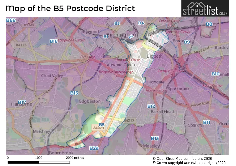
The B5 Postcode shares a border with B1 (BIRMINGHAM), B15 (BIRMINGHAM, Edgbaston), B9 (BIRMINGHAM, Bordesley Green, Small Heath), B12 (BIRMINGHAM, Balsall Heath, Deritend) and B29 (BIRMINGHAM, Selly Oak, Selly Park).
The primary settlement in the B5 postcode district is Birmingham in the county of West Midlands, England. Other significant settlements in the district include Balsall Heath and Edgbaston. The most significant post town in the district is Birmingham.
For the district B5, we have data on 4 postcode sectors. Here's a breakdown: The sector B5 4, covers Birmingham in West Midlands. The sector B5 5, covers Birmingham in West Midlands. The sector B5 6, covers Birmingham in West Midlands. The sector B5 7, covers Birmingham in West Midlands.

Map of the B5 Postcode District
Explore the B5 postcode district by using our free interactive map.
When it comes to local government, postal geography often disregards political borders. However, for a breakdown in the B5 District: the district mostly encompasses the Birmingham District (B) area with a total of 407 postcodes.
Weather Forecast for B5
Press Button to Show Forecast for Edgbaston Warwickshire C.C.C.
| Time Period | Icon | Description | Temperature | Rain Probability | Wind |
|---|---|---|---|---|---|
| 09:00 to 12:00 | Cloudy | 8.0°C (feels like 5.0°C) | 7.00% | WNW 9 mph | |
| 12:00 to 15:00 | Overcast | 9.0°C (feels like 7.0°C) | 13.00% | NW 9 mph | |
| 15:00 to 18:00 | Cloudy | 9.0°C (feels like 7.0°C) | 11.00% | N 7 mph | |
| 18:00 to 21:00 | Cloudy | 9.0°C (feels like 7.0°C) | 8.00% | NNE 7 mph | |
| 21:00 to 00:00 | Cloudy | 7.0°C (feels like 6.0°C) | 4.00% | ENE 4 mph |
Press Button to Show Forecast for Edgbaston Warwickshire C.C.C.
| Time Period | Icon | Description | Temperature | Rain Probability | Wind |
|---|---|---|---|---|---|
| 00:00 to 03:00 | Cloudy | 6.0°C (feels like 4.0°C) | 8.00% | E 7 mph | |
| 03:00 to 06:00 | Cloudy | 5.0°C (feels like 3.0°C) | 7.00% | E 4 mph | |
| 06:00 to 09:00 | Cloudy | 4.0°C (feels like 2.0°C) | 5.00% | ENE 4 mph | |
| 09:00 to 12:00 | Cloudy | 6.0°C (feels like 4.0°C) | 6.00% | ENE 7 mph | |
| 12:00 to 15:00 | Overcast | 9.0°C (feels like 7.0°C) | 11.00% | ENE 7 mph | |
| 15:00 to 18:00 | Overcast | 10.0°C (feels like 8.0°C) | 12.00% | E 7 mph | |
| 18:00 to 21:00 | Cloudy | 9.0°C (feels like 8.0°C) | 10.00% | ENE 7 mph | |
| 21:00 to 00:00 | Partly cloudy (night) | 7.0°C (feels like 5.0°C) | 9.00% | ENE 7 mph |
Press Button to Show Forecast for Edgbaston Warwickshire C.C.C.
| Time Period | Icon | Description | Temperature | Rain Probability | Wind |
|---|---|---|---|---|---|
| 00:00 to 03:00 | Cloudy | 5.0°C (feels like 3.0°C) | 12.00% | ENE 7 mph | |
| 03:00 to 06:00 | Cloudy | 4.0°C (feels like 2.0°C) | 13.00% | ENE 7 mph | |
| 06:00 to 09:00 | Cloudy | 5.0°C (feels like 2.0°C) | 14.00% | ENE 7 mph | |
| 09:00 to 12:00 | Cloudy | 7.0°C (feels like 4.0°C) | 19.00% | ENE 9 mph | |
| 12:00 to 15:00 | Light rain | 9.0°C (feels like 6.0°C) | 53.00% | ENE 9 mph | |
| 15:00 to 18:00 | Overcast | 10.0°C (feels like 8.0°C) | 23.00% | ENE 9 mph | |
| 18:00 to 21:00 | Cloudy | 10.0°C (feels like 7.0°C) | 19.00% | ENE 9 mph | |
| 21:00 to 00:00 | Cloudy | 8.0°C (feels like 6.0°C) | 22.00% | NE 9 mph |
Press Button to Show Forecast for Edgbaston Warwickshire C.C.C.
| Time Period | Icon | Description | Temperature | Rain Probability | Wind |
|---|---|---|---|---|---|
| 00:00 to 03:00 | Light rain | 7.0°C (feels like 4.0°C) | 52.00% | NE 9 mph | |
| 03:00 to 06:00 | Heavy rain | 7.0°C (feels like 4.0°C) | 71.00% | NE 9 mph | |
| 06:00 to 09:00 | Heavy rain | 7.0°C (feels like 4.0°C) | 73.00% | NE 9 mph | |
| 09:00 to 12:00 | Heavy rain | 8.0°C (feels like 6.0°C) | 75.00% | NNE 9 mph | |
| 12:00 to 15:00 | Light rain shower (day) | 10.0°C (feels like 8.0°C) | 43.00% | NNE 9 mph | |
| 15:00 to 18:00 | Heavy rain shower (day) | 11.0°C (feels like 9.0°C) | 59.00% | NW 9 mph | |
| 18:00 to 21:00 | Heavy rain shower (day) | 11.0°C (feels like 9.0°C) | 53.00% | NNW 9 mph | |
| 21:00 to 00:00 | Clear night | 9.0°C (feels like 7.0°C) | 11.00% | WNW 7 mph |
Where is the B5 Postcode District?
The postcode district B5 is located in Birmingham. It is in close proximity to several towns: Smethwick is located to the North West at a distance of approximately 3.53 miles, Solihull is situated to the South East at a distance of approximately 4.07 miles, Rowley Regis is located to the West at a distance of approximately 6.18 miles, and Sutton Coldfield is situated to the North at a distance of approximately 7.84 miles. Furthermore, the postcode district B5 is approximately 100.52 miles away from the center of London.
The district is within the post town of BIRMINGHAM.
The sector has postcodes within the nation of England.
The B5 Postcode District is in the Birmingham region of West Midlands within the West Midlands (England).
| Postcode Sector | Delivery Office |
|---|---|
| B5 4 | Birmingham Central Delivery Office |
| B5 5 | Birmingham Central Delivery Office |
| B5 6 | Birmingham Central Delivery Office |
| B5 7 | Birmingham Central Delivery Office |
| B | 5 | - | X | X | X |
| B | 5 | Space | Numeric | Letter | Letter |
Tourist Attractions within the Postcode Area
We found 1 visitor attractions within the B5 postcode area
| Birmingham Back to Backs |
|---|
| Historic Properties |
| Historic House / House and Garden / Palace |
| View Birmingham Back to Backs on Google Maps |
Current Monthly Rental Prices
| # Bedrooms | Min Price | Max Price | Avg Price |
|---|---|---|---|
| 1 | £2,000 | £2,000 | £2,000 |
| 2 | £1,500 | £3,000 | £1,869 |
| 3 | £2,600 | £2,600 | £2,600 |
| 4 | £1,508 | £4,500 | £2,763 |
| 5 | £1,775 | £2,195 | £1,940 |
| 6 | £2,395 | £4,000 | £3,599 |
| 11 | £13,500 | £13,500 | £13,500 |
Current House Prices
| # Bedrooms | Min Price | Max Price | Avg Price |
|---|---|---|---|
| £710,000 | £710,000 | £710,000 | |
| 2 | £326,000 | £381,231 | £347,099 |
| 3 | £335,000 | £680,818 | £410,753 |
| 4 | £375,000 | £375,000 | £375,000 |
Estate Agents who Operate in the B5 District
| Logo | Name | Brand Name | Address | Contact Number | Total Properties |
|---|---|---|---|---|---|
 | Birmingham | Northwood | 70 Bromsgrove Street, Birmingham, B5 6NU | 0121 387 6640 | 27 |
 | Manchester | Rothmore Property | Manchester One, 53 Portland Street, MANCHESTER, M1 3LD | 01202 145412 | 22 |
 | Birmingham | Eight8 Property | Studio 10, 50-54 St Pauls Place, Birmingham, B3 1QS | 0121 387 6424 | 20 |
 | Birmingham City | Connells | 145 Great Charles Street Queensway Birmingham B3 3LP | 0121 387 6591 | 18 |
 | Manchester | RW Invest | 8 Exchange Quay, Salford, M5 3EJ | 0161 524 4934 | 10 |
| Type of Property | 2018 Average | 2018 Sales | 2017 Average | 2017 Sales | 2016 Average | 2016 Sales | 2015 Average | 2015 Sales |
|---|---|---|---|---|---|---|---|---|
| Detached | £508,096 | 13 | £481,172 | 7 | £244,000 | 2 | £359,786 | 7 |
| Semi-Detached | £244,417 | 6 | £196,333 | 6 | £171,000 | 7 | £214,000 | 5 |
| Terraced | £213,688 | 17 | £253,464 | 14 | £154,039 | 23 | £204,444 | 25 |
| Flats | £192,966 | 275 | £170,895 | 165 | £161,194 | 188 | £142,637 | 197 |