The B50 postcode district is a postal district located in the B Birmingham postcode area with a population of 6,979 residents according to the 2021 England and Wales Census.
The area of the B50 postcode district is 7.95 square miles which is 20.58 square kilometres or 5,084.92 acres.
Currently, the B50 district has about 207 postcode units spread across 1 geographic postcode sectors.
Given that each sector allows for 400 unique postcode combinations, the district has a capacity of 400 postcodes. With 207 postcodes already in use, this leaves 193 units available.
The largest settlements in the B50 postal code are Bidford-on-Avon and Broom.
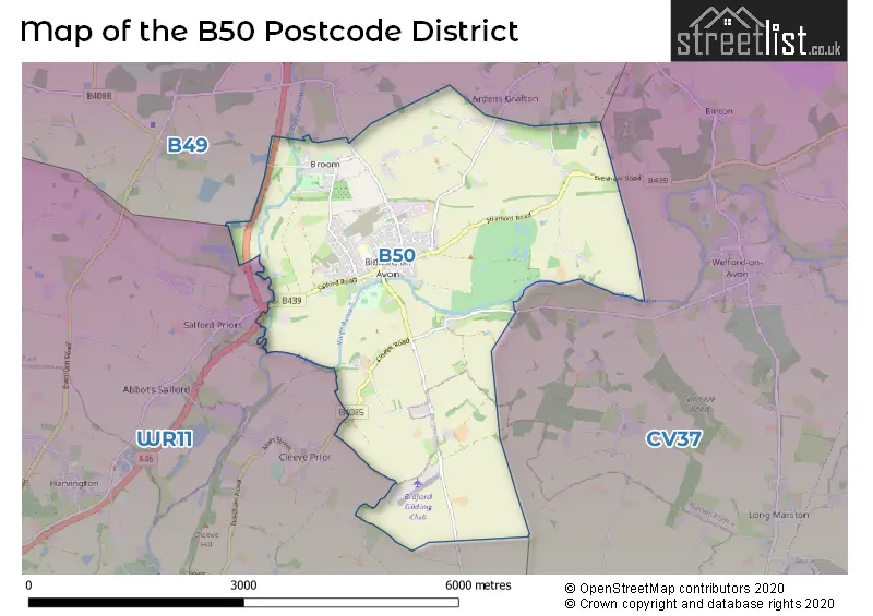
The B50 Postcode shares a border with CV37 (STRATFORD-UPON-AVON, Welford On Avon, Lower Quinton), WR11 (EVESHAM, Badsey, Honeybourne) and B49 (ALCESTER, Great Alne, Cookhill).
The primary settlement in the B50 postcode district is Bidford-on-Avon, located in the county of Warwickshire. There are also significant settlements of Broom and Alcester in the same postcode district. The main post town for this district is Alcester, which is also in Warwickshire.
For the district B50, we have data on 1 postcode sectors. Here's a breakdown: The sector B50 4, covers Bidford-On-Avon in Warwickshire.
B50 Postcode Sectors

Map of the B50 Postcode District
Explore the B50 postcode district by using our free interactive map.
When it comes to local government, postal geography often disregards political borders. However, for a breakdown in the B50 District: the district mostly encompasses the Stratford-on-Avon District (205 postcodes), and finally, the Wychavon District area (4 postcodes).
Weather Forecast for B50
Press Button to Show Forecast for Ragley Hall
| Time Period | Icon | Description | Temperature | Rain Probability | Wind |
|---|---|---|---|---|---|
| 15:00 to 18:00 | Cloudy | 11.0°C (feels like 9.0°C) | 5.00% | N 11 mph | |
| 18:00 to 21:00 | Cloudy | 10.0°C (feels like 9.0°C) | 5.00% | NE 7 mph | |
| 21:00 to 00:00 | Overcast | 8.0°C (feels like 7.0°C) | 8.00% | NNE 4 mph |
Press Button to Show Forecast for Ragley Hall
| Time Period | Icon | Description | Temperature | Rain Probability | Wind |
|---|---|---|---|---|---|
| 00:00 to 03:00 | Cloudy | 7.0°C (feels like 5.0°C) | 5.00% | N 4 mph | |
| 03:00 to 06:00 | Cloudy | 6.0°C (feels like 5.0°C) | 5.00% | NNW 2 mph | |
| 06:00 to 09:00 | Cloudy | 6.0°C (feels like 5.0°C) | 8.00% | N 4 mph | |
| 09:00 to 12:00 | Cloudy | 8.0°C (feels like 5.0°C) | 3.00% | N 7 mph | |
| 12:00 to 15:00 | Partly cloudy (day) | 10.0°C (feels like 9.0°C) | 1.00% | N 9 mph | |
| 15:00 to 18:00 | Cloudy | 12.0°C (feels like 10.0°C) | 3.00% | NNW 7 mph | |
| 18:00 to 21:00 | Sunny day | 11.0°C (feels like 9.0°C) | 1.00% | NNW 7 mph | |
| 21:00 to 00:00 | Clear night | 6.0°C (feels like 4.0°C) | 1.00% | N 4 mph |
Press Button to Show Forecast for Ragley Hall
| Time Period | Icon | Description | Temperature | Rain Probability | Wind |
|---|---|---|---|---|---|
| 00:00 to 03:00 | Partly cloudy (night) | 4.0°C (feels like 2.0°C) | 2.00% | NW 4 mph | |
| 03:00 to 06:00 | Cloudy | 3.0°C (feels like 1.0°C) | 4.00% | WNW 4 mph | |
| 06:00 to 09:00 | Cloudy | 4.0°C (feels like 2.0°C) | 6.00% | W 4 mph | |
| 09:00 to 12:00 | Cloudy | 8.0°C (feels like 6.0°C) | 9.00% | W 7 mph | |
| 12:00 to 15:00 | Cloudy | 10.0°C (feels like 8.0°C) | 11.00% | NW 9 mph | |
| 15:00 to 18:00 | Cloudy | 11.0°C (feels like 9.0°C) | 9.00% | NW 7 mph | |
| 18:00 to 21:00 | Cloudy | 10.0°C (feels like 8.0°C) | 7.00% | NNW 7 mph | |
| 21:00 to 00:00 | Cloudy | 7.0°C (feels like 5.0°C) | 5.00% | NNE 4 mph |
Press Button to Show Forecast for Ragley Hall
| Time Period | Icon | Description | Temperature | Rain Probability | Wind |
|---|---|---|---|---|---|
| 00:00 to 03:00 | Cloudy | 5.0°C (feels like 3.0°C) | 7.00% | NE 4 mph | |
| 03:00 to 06:00 | Cloudy | 4.0°C (feels like 2.0°C) | 10.00% | ESE 7 mph | |
| 06:00 to 09:00 | Cloudy | 5.0°C (feels like 2.0°C) | 13.00% | ESE 7 mph | |
| 09:00 to 12:00 | Cloudy | 7.0°C (feels like 5.0°C) | 14.00% | ESE 9 mph | |
| 12:00 to 15:00 | Overcast | 10.0°C (feels like 8.0°C) | 18.00% | ESE 9 mph | |
| 15:00 to 18:00 | Overcast | 10.0°C (feels like 8.0°C) | 19.00% | ESE 9 mph | |
| 18:00 to 21:00 | Cloudy | 9.0°C (feels like 7.0°C) | 19.00% | ESE 7 mph | |
| 21:00 to 00:00 | Cloudy | 7.0°C (feels like 5.0°C) | 21.00% | ESE 7 mph |
Press Button to Show Forecast for Ragley Hall
| Time Period | Icon | Description | Temperature | Rain Probability | Wind |
|---|---|---|---|---|---|
| 00:00 to 03:00 | Light rain | 6.0°C (feels like 4.0°C) | 48.00% | ESE 9 mph | |
| 03:00 to 06:00 | Light rain | 5.0°C (feels like 3.0°C) | 51.00% | ENE 7 mph | |
| 06:00 to 09:00 | Overcast | 6.0°C (feels like 3.0°C) | 20.00% | NNE 9 mph | |
| 09:00 to 12:00 | Cloudy | 8.0°C (feels like 6.0°C) | 19.00% | ENE 9 mph | |
| 12:00 to 15:00 | Cloudy | 10.0°C (feels like 8.0°C) | 18.00% | E 9 mph | |
| 15:00 to 18:00 | Light rain | 11.0°C (feels like 9.0°C) | 51.00% | E 9 mph | |
| 18:00 to 21:00 | Heavy rain shower (day) | 10.0°C (feels like 8.0°C) | 57.00% | E 9 mph | |
| 21:00 to 00:00 | Cloudy | 9.0°C (feels like 7.0°C) | 21.00% | ENE 9 mph |
Where is the B50 Postcode District?
The postcode district B50 is located in the town of Alcester. Alcester is surrounded by several nearby towns. To the east is Stratford-upon-Avon, which is approximately 6.43 miles away. To the southwest is Evesham, which is about 6.45 miles away. To the north is Studley, approximately 7.96 miles away. To the southeast is Chipping Campden, which is about 8.27 miles away. To the south is Broadway, which is approximately 8.8 miles away. To the west is Pershore, which is about 10.74 miles away. Additionally, Alcester is approximately 86.45 miles away from the center of London.
The district is within the post town of ALCESTER.
The sector has postcodes within the nation of England.
The B50 Postcode District is covers the following regions.
- Warwickshire - Herefordshire, Worcestershire and Warwickshire - West Midlands (England)
- Worcestershire - Herefordshire, Worcestershire and Warwickshire - West Midlands (England)
Postcode Sectors within the B50 District
| Postcode Sector | Delivery Office |
|---|---|
| B50 4 | Alcester Delivery Office |
| B | 5 | 0 | - | X | X | X |
| B | 5 | 0 | Space | Numeric | Letter | Letter |
Current Monthly Rental Prices
| # Bedrooms | Min Price | Max Price | Avg Price |
|---|---|---|---|
| 3 | £1,100 | £1,100 | £1,100 |
Current House Prices
| # Bedrooms | Min Price | Max Price | Avg Price |
|---|---|---|---|
| 2 | £550,000 | £550,000 | £550,000 |
| 3 | £375,000 | £450,000 | £407,000 |
| 4 | £379,950 | £795,000 | £484,657 |
| 5 | £415,000 | £1,300,000 | £746,667 |
| 9 | £4,500,000 | £4,500,000 | £4,500,000 |
Estate Agents who Operate in the B50 District
| Logo | Name | Brand Name | Address | Contact Number | Total Properties |
|---|---|---|---|---|---|
 | Alcester | Sanders & Sanders | Burton House High Street, Alcester, B49 5AB | 01789 339291 | 11 |
 | Evesham | Avon Estates Sales & Lettings | 7 Vine Street, Evesham, WR11 4RE | 01386 574232 | 10 |
 | Stratford Upon Avon | King Homes | Guild Street, Stratford-Upon-Avon, CV37 6QY | 01789 339387 | 9 |
 | Stratford Upon Avon | R A Bennett & Partners | 46 Sheep Street, Stratford upon Avon, Warwickshire, CV37 6EE | 01789 337274 | 4 |
 | Stratford-Upon-Avon | Sheldon Bosley Knight | 35 -36 Rother Street Stratford Upon Avon Warwickshire CV37 6LP | 01789 339361 | 3 |
| Type of Property | 2018 Average | 2018 Sales | 2017 Average | 2017 Sales | 2016 Average | 2016 Sales | 2015 Average | 2015 Sales |
|---|---|---|---|---|---|---|---|---|
| Detached | £397,461 | 90 | £375,947 | 94 | £318,681 | 60 | £303,361 | 89 |
| Semi-Detached | £250,156 | 48 | £223,796 | 75 | £232,653 | 47 | £200,275 | 43 |
| Terraced | £174,744 | 43 | £213,519 | 27 | £200,318 | 47 | £190,610 | 31 |
| Flats | £132,000 | 7 | £156,188 | 8 | £128,140 | 5 | £169,390 | 10 |