The B94 postcode district is a postal district located in the B Birmingham postcode area with a population of 7,680 residents according to the 2021 England and Wales Census.
The area of the B94 postcode district is 22.40 square miles which is 58.02 square kilometres or 14,338.16 acres.
Currently, the B94 district has about 336 postcode units spread across 2 geographic postcode sectors.
Given that each sector allows for 400 unique postcode combinations, the district has a capacity of 800 postcodes. With 336 postcodes already in use, this leaves 464 units available.
The largest settlement in the B94 postal code is Hockley Heath followed by Lapworth, and Earlswood.
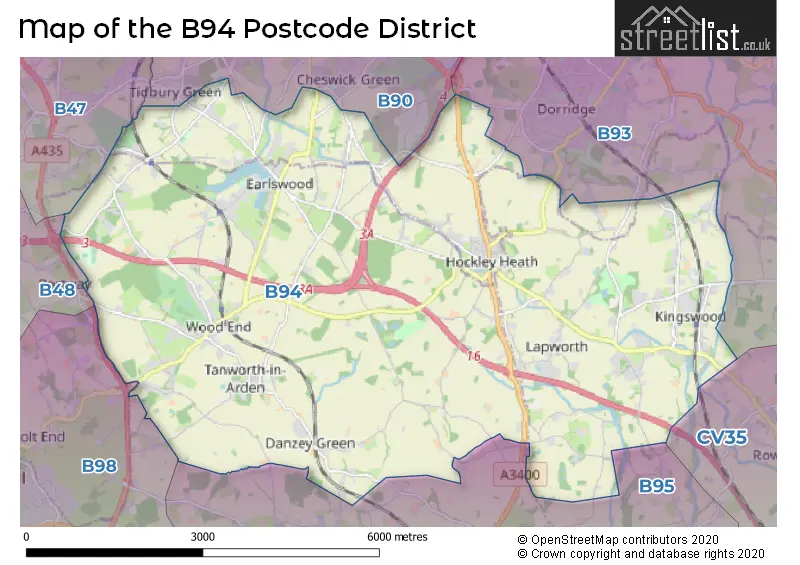
The B94 Postcode shares a border with B93 (Knowle, Dorridge, Bentley Heath), B95 (HENLEY-IN-ARDEN, Wootton Wawen, Ullenhall), B98 (REDDITCH, Beoley, Moons Moat North Industrial Estate), B90 (Shirley, Cheswick Green, Tidbury Green) and B47 (Hollywood, Wythall).
The B94 postcode district is primarily represented by the settlement of Earlswood in the post town of Solihull, located in the county of Warwickshire. Other significant settlements in this postcode district include Hockley Heath and Lapworth, both also located in the post town of Solihull. These settlements are also located in the county of Warwickshire. Additionally, there is Tanworth-in-Arden, which is located in the county of Warwickshire as well. The most significant postal town in this postcode district, based on the highest postcode count, is Solihull.
For the district B94, we have data on 2 postcode sectors. Here's a breakdown: The sector B94 5, covers Tanworth-In-Arden and Earlswood and Lapworth and Hockley Heath in Warwickshire. The sector B94 6, covers Hockley Heath in West Midlands. The sector B94 6, covers Lapworth in Warwickshire.

Map of the B94 Postcode District
Explore the B94 postcode district by using our free interactive map.
When it comes to local government, postal geography often disregards political borders. However, for a breakdown in the B94 District: the district mostly encompasses the Stratford-on-Avon District (132 postcodes), followed by the Solihull District (B) area (108 postcodes), and finally, the Warwick District area (100 postcodes).
Weather Forecast for B94
Press Button to Show Forecast for Packwood House
| Time Period | Icon | Description | Temperature | Rain Probability | Wind |
|---|---|---|---|---|---|
| 18:00 to 21:00 | Cloudy | 9.0°C (feels like 6.0°C) | 30.00% | N 9 mph | |
| 21:00 to 00:00 | Cloudy | 6.0°C (feels like 5.0°C) | 5.00% | NE 7 mph |
Press Button to Show Forecast for Packwood House
| Time Period | Icon | Description | Temperature | Rain Probability | Wind |
|---|---|---|---|---|---|
| 00:00 to 03:00 | Cloudy | 4.0°C (feels like 2.0°C) | 3.00% | NNE 4 mph | |
| 03:00 to 06:00 | Cloudy | 3.0°C (feels like 2.0°C) | 3.00% | NNW 4 mph | |
| 06:00 to 09:00 | Partly cloudy (day) | 4.0°C (feels like 2.0°C) | 1.00% | NNW 4 mph | |
| 09:00 to 12:00 | Cloudy | 7.0°C (feels like 5.0°C) | 4.00% | N 7 mph | |
| 12:00 to 15:00 | Cloudy | 10.0°C (feels like 8.0°C) | 5.00% | N 9 mph | |
| 15:00 to 18:00 | Overcast | 11.0°C (feels like 9.0°C) | 8.00% | N 7 mph | |
| 18:00 to 21:00 | Cloudy | 10.0°C (feels like 8.0°C) | 5.00% | NNE 7 mph | |
| 21:00 to 00:00 | Cloudy | 7.0°C (feels like 6.0°C) | 5.00% | NNE 4 mph |
Press Button to Show Forecast for Packwood House
| Time Period | Icon | Description | Temperature | Rain Probability | Wind |
|---|---|---|---|---|---|
| 00:00 to 03:00 | Clear night | 5.0°C (feels like 4.0°C) | 1.00% | NNE 4 mph | |
| 03:00 to 06:00 | Cloudy | 5.0°C (feels like 4.0°C) | 8.00% | NNE 2 mph | |
| 06:00 to 09:00 | Cloudy | 5.0°C (feels like 4.0°C) | 6.00% | NNE 4 mph | |
| 09:00 to 12:00 | Cloudy | 7.0°C (feels like 5.0°C) | 8.00% | NNE 7 mph | |
| 12:00 to 15:00 | Overcast | 9.0°C (feels like 7.0°C) | 12.00% | NNE 9 mph | |
| 15:00 to 18:00 | Overcast | 10.0°C (feels like 8.0°C) | 10.00% | NE 9 mph | |
| 18:00 to 21:00 | Cloudy | 9.0°C (feels like 7.0°C) | 8.00% | NE 9 mph | |
| 21:00 to 00:00 | Partly cloudy (night) | 7.0°C (feels like 5.0°C) | 6.00% | NE 7 mph |
Press Button to Show Forecast for Packwood House
| Time Period | Icon | Description | Temperature | Rain Probability | Wind |
|---|---|---|---|---|---|
| 00:00 to 03:00 | Partly cloudy (night) | 5.0°C (feels like 3.0°C) | 4.00% | ENE 4 mph | |
| 03:00 to 06:00 | Partly cloudy (night) | 3.0°C (feels like 2.0°C) | 6.00% | NE 4 mph | |
| 06:00 to 09:00 | Overcast | 4.0°C (feels like 3.0°C) | 14.00% | NNE 4 mph | |
| 09:00 to 12:00 | Overcast | 7.0°C (feels like 6.0°C) | 15.00% | NE 4 mph | |
| 12:00 to 15:00 | Cloudy | 8.0°C (feels like 7.0°C) | 19.00% | ESE 4 mph | |
| 15:00 to 18:00 | Cloudy | 9.0°C (feels like 7.0°C) | 17.00% | E 7 mph | |
| 18:00 to 21:00 | Cloudy | 8.0°C (feels like 7.0°C) | 16.00% | ENE 7 mph | |
| 21:00 to 00:00 | Cloudy | 7.0°C (feels like 6.0°C) | 13.00% | NNE 4 mph |
Press Button to Show Forecast for Packwood House
| Time Period | Icon | Description | Temperature | Rain Probability | Wind |
|---|---|---|---|---|---|
| 00:00 to 03:00 | Cloudy | 6.0°C (feels like 5.0°C) | 8.00% | NE 4 mph | |
| 03:00 to 06:00 | Cloudy | 6.0°C (feels like 4.0°C) | 7.00% | NNE 4 mph | |
| 06:00 to 09:00 | Cloudy | 6.0°C (feels like 4.0°C) | 7.00% | N 4 mph | |
| 09:00 to 12:00 | Cloudy | 8.0°C (feels like 6.0°C) | 8.00% | N 7 mph | |
| 12:00 to 15:00 | Overcast | 10.0°C (feels like 8.0°C) | 12.00% | N 9 mph | |
| 15:00 to 18:00 | Overcast | 12.0°C (feels like 10.0°C) | 12.00% | NNE 9 mph | |
| 18:00 to 21:00 | Overcast | 11.0°C (feels like 9.0°C) | 9.00% | NNE 9 mph | |
| 21:00 to 00:00 | Partly cloudy (night) | 8.0°C (feels like 6.0°C) | 3.00% | NNE 7 mph |
Where is the B94 Postcode District?
The postcode district B94 is located in Solihull, which is a town in the West Midlands region of England. Nearby towns include Henley-in-Arden to the south (3.2 miles away), Studley to the southwest (6.1 miles away), Kenilworth to the east (9 miles away), Birmingham to the north (9 miles away), Bromsgrove to the west (10.2 miles away), and Warwick to the southeast (10.7 miles away). In terms of distance, B94 is approximately 92.1 miles away from the centre of London.
The district is within the post town of SOLIHULL.
The sector has postcodes within the nation of England.
The B94 Postcode District is covers the following regions.
- Warwickshire - Herefordshire, Worcestershire and Warwickshire - West Midlands (England)
- Solihull - West Midlands - West Midlands (England)
| Postcode Sector | Delivery Office |
|---|---|
| B94 5 | Knowle Delivery Office |
| B94 6 | Knowle Delivery Office |
| B | 9 | 4 | - | X | X | X |
| B | 9 | 4 | Space | Numeric | Letter | Letter |
Tourist Attractions within the Postcode Area
We found 1 visitor attractions within the B94 postcode area
| Packwood House |
|---|
| Historic Properties |
| Historic House / House and Garden / Palace |
| View Packwood House on Google Maps |
Current Monthly Rental Prices
| # Bedrooms | Min Price | Max Price | Avg Price |
|---|---|---|---|
| £2,000 | £2,000 | £2,000 | |
| 2 | £925 | £1,695 | £1,310 |
| 3 | £1,400 | £2,750 | £2,250 |
| 5 | £7,000 | £7,000 | £7,000 |
Current House Prices
| # Bedrooms | Min Price | Max Price | Avg Price |
|---|---|---|---|
| 3 | £1,250,000 | £1,250,000 | £1,250,000 |
| 4 | £1,195,000 | £1,700,000 | £1,437,500 |
| 5 | £1,300,000 | £2,250,000 | £1,657,778 |
| 6 | £1,195,000 | £3,295,000 | £1,931,667 |
| 7 | £1,750,000 | £3,000,000 | £2,375,000 |
| 8 | £6,250,000 | £6,250,000 | £6,250,000 |
Estate Agents who Operate in the B94 District
| Logo | Name | Brand Name | Address | Contact Number | Total Properties |
|---|---|---|---|---|---|
 | Knowle | Xact Homes | 1632-1634, High Street, Knowle, Solihull, B93 0JU | 01564 334705 | 13 |
 | Knowle | EB&P | EB&P Limited 124 Station Road Knowle Solihull B93 0EP | 01564 331105 | 11 |
 | Stratford Upon Avon | Knight Frank | Bridgeway, Stratford upon Avon, Warwickshire, CV37 6YX | 01789 335860 | 5 |
 | Stratford-upon-Avon | Knight Frank - New Homes | Bridgeway House Bridgeway, Stratford-Upon-Avon, CV37 6YX | 01704 338930 | 4 |
 | Dorridge | DM & Co. Homes | 2 Forest Court Shopping Centre, Solihull, B93 8FG | 0121 387 6788 | 4 |
| Type of Property | 2018 Average | 2018 Sales | 2017 Average | 2017 Sales | 2016 Average | 2016 Sales | 2015 Average | 2015 Sales |
|---|---|---|---|---|---|---|---|---|
| Detached | £837,848 | 66 | £632,344 | 70 | £671,000 | 51 | £687,622 | 69 |
| Semi-Detached | £366,083 | 29 | £378,173 | 39 | £340,013 | 35 | £346,863 | 28 |
| Terraced | £386,431 | 8 | £341,495 | 14 | £312,403 | 16 | £316,155 | 15 |
| Flats | £364,917 | 6 | £310,714 | 7 | £260,000 | 5 | £283,217 | 9 |
Hotels within the Postcode Area
We found 7 hotels and guest houses within the B94 postcode area
Nuthurst Grange Country House Hotel & Restaurant
Nuthurst Grange Lane, Hockley Heath, Solihull, solihull, B94 5NL.
View detailsIllshaw Heath Farm
Illshaw Heath Farm, Kineton Lane, Hockley Heath, hockley-heath, B94 6RX.
View details