The BH24 postcode district is a postal district located in the BH Bournemouth postcode area with a population of 24,892 residents according to the 2021 England and Wales Census.
The area of the BH24 postcode district is 57.38 square miles which is 148.62 square kilometres or 36,725.07 acres.
Currently, the BH24 district has about 812 postcode units spread across 4 geographic postcode sectors.
Given that each sector allows for 400 unique postcode combinations, the district has a capacity of 1,600 postcodes. With 812 postcodes already in use, this leaves 788 units available.
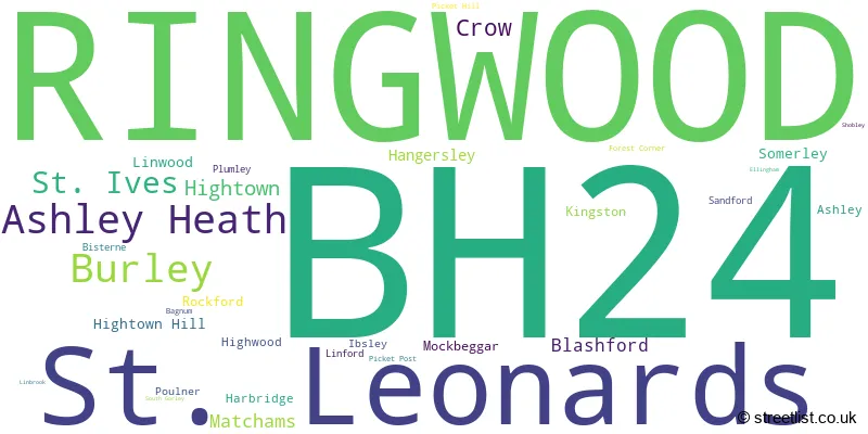
The largest settlement in the BH24 postal code is RINGWOOD followed by St. Leonards, and Ashley Heath.
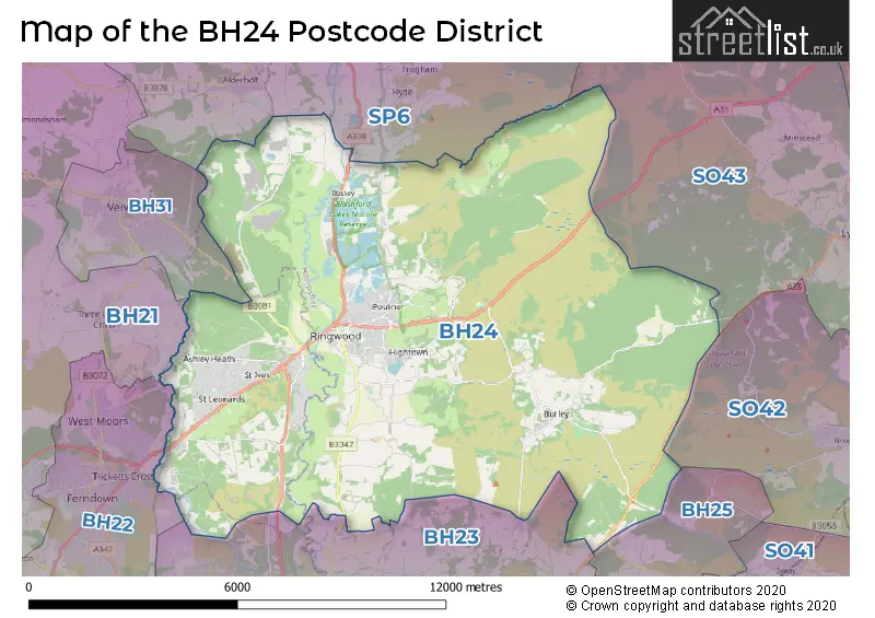
The BH24 Postcode shares a border with BH21 (WIMBORNE, Corfe Mullen, Three Legged Cross), BH22 (FERNDOWN, West Moors, West Parley), BH31 (VERWOOD, Ebblake Industrial Estate), SP6 (FORDINGBRIDGE, Alderholt, Godshill), BH23 (CHRISTCHURCH, Highcliffe, Bransgore) and SO43 (LYNDHURST, Minstead, Bramshaw).
The primary settlement in the BH24 postcode district is Ringwood, located in the county of Hampshire in England. Other significant settlements in this district include Ashley, Ashley Heath, Matchams, St. Ives, and St. Leonards. The most significant post town in this district is also Ringwood.
For the district BH24, we have data on 5 postcode sectors. Here's a breakdown: The sector BH24 1, covers Ringwood in Hampshire. The sector BH24 2, covers St. Leonards and Ashley Heath and St. Ives and Ringwood in Dorset. The sector BH24 3, covers Ringwood in Hampshire. The sector BH24 4, covers Burley in Hampshire. The sector BH24 9 is non-geographic. It's often designated for PO Boxes, large organisations, or special services.

Map of the BH24 Postcode District
Explore the BH24 postcode district by using our free interactive map.
When it comes to local government, postal geography often disregards political borders. However, for a breakdown in the BH24 District: the district mostly encompasses the New Forest District (576 postcodes), and finally, the Dorset area (239 postcodes).
Weather Forecast for BH24
Press Button to Show Forecast for Ringwood
| Time Period | Icon | Description | Temperature | Rain Probability | Wind |
|---|---|---|---|---|---|
| 12:00 to 15:00 | Cloudy | 11.0°C (feels like 10.0°C) | 5.00% | NW 7 mph | |
| 15:00 to 18:00 | Cloudy | 12.0°C (feels like 11.0°C) | 5.00% | NNW 7 mph | |
| 18:00 to 21:00 | Sunny day | 11.0°C (feels like 10.0°C) | 1.00% | NNE 7 mph | |
| 21:00 to 00:00 | Clear night | 8.0°C (feels like 6.0°C) | 1.00% | NNE 4 mph |
Press Button to Show Forecast for Ringwood
| Time Period | Icon | Description | Temperature | Rain Probability | Wind |
|---|---|---|---|---|---|
| 00:00 to 03:00 | Partly cloudy (night) | 6.0°C (feels like 5.0°C) | 1.00% | NNE 4 mph | |
| 03:00 to 06:00 | Cloudy | 5.0°C (feels like 4.0°C) | 4.00% | W 4 mph | |
| 06:00 to 09:00 | Sunny day | 6.0°C (feels like 4.0°C) | 2.00% | NNW 4 mph | |
| 09:00 to 12:00 | Partly cloudy (day) | 10.0°C (feels like 8.0°C) | 2.00% | WNW 7 mph | |
| 12:00 to 15:00 | Overcast | 11.0°C (feels like 9.0°C) | 11.00% | W 11 mph | |
| 15:00 to 18:00 | Overcast | 12.0°C (feels like 9.0°C) | 12.00% | W 11 mph | |
| 18:00 to 21:00 | Cloudy | 11.0°C (feels like 9.0°C) | 6.00% | W 9 mph | |
| 21:00 to 00:00 | Cloudy | 8.0°C (feels like 7.0°C) | 6.00% | WNW 7 mph |
Press Button to Show Forecast for Ringwood
| Time Period | Icon | Description | Temperature | Rain Probability | Wind |
|---|---|---|---|---|---|
| 00:00 to 03:00 | Cloudy | 7.0°C (feels like 5.0°C) | 7.00% | NW 4 mph | |
| 03:00 to 06:00 | Partly cloudy (night) | 6.0°C (feels like 5.0°C) | 5.00% | N 4 mph | |
| 06:00 to 09:00 | Cloudy | 7.0°C (feels like 5.0°C) | 12.00% | N 4 mph | |
| 09:00 to 12:00 | Cloudy | 10.0°C (feels like 8.0°C) | 15.00% | SE 9 mph | |
| 12:00 to 15:00 | Cloudy | 10.0°C (feels like 8.0°C) | 18.00% | SSE 11 mph | |
| 15:00 to 18:00 | Cloudy | 11.0°C (feels like 8.0°C) | 17.00% | S 11 mph | |
| 18:00 to 21:00 | Cloudy | 10.0°C (feels like 8.0°C) | 17.00% | SE 9 mph | |
| 21:00 to 00:00 | Cloudy | 9.0°C (feels like 7.0°C) | 16.00% | SE 9 mph |
Press Button to Show Forecast for Ringwood
| Time Period | Icon | Description | Temperature | Rain Probability | Wind |
|---|---|---|---|---|---|
| 00:00 to 03:00 | Cloudy | 8.0°C (feels like 6.0°C) | 22.00% | SE 7 mph | |
| 03:00 to 06:00 | Light rain | 8.0°C (feels like 6.0°C) | 48.00% | ESE 7 mph | |
| 06:00 to 09:00 | Cloudy | 8.0°C (feels like 6.0°C) | 17.00% | E 7 mph | |
| 09:00 to 12:00 | Cloudy | 11.0°C (feels like 8.0°C) | 20.00% | ESE 11 mph | |
| 12:00 to 15:00 | Cloudy | 12.0°C (feels like 9.0°C) | 22.00% | ESE 11 mph | |
| 15:00 to 18:00 | Light rain | 12.0°C (feels like 10.0°C) | 52.00% | SE 11 mph | |
| 18:00 to 21:00 | Light rain shower (day) | 11.0°C (feels like 9.0°C) | 42.00% | NE 9 mph | |
| 21:00 to 00:00 | Light rain | 10.0°C (feels like 8.0°C) | 59.00% | NNE 9 mph |
Where is the BH24 Postcode District?
The postcode district BH24 is located in the town of Ringwood. It is situated near several towns including Fordingbridge to the north, Verwood to the west, Christchurch to the south, New Milton to the southeast, Ferndown to the southwest, and Lyndhurst to the east. The distance from Ringwood to London is approximately 84.11 miles.
The district covers the post towns of RINGWOOD, VERWOOD.
The sector has postcodes within the nation of England.
The BH24 Postcode District is in the Central Hampshire region of Hampshire and Isle of Wight within the South East (England).
| Postcode Sector | Delivery Office |
|---|---|
| BH24 1 | Ringwood Delivery Office |
| BH24 2 | Ringwood Delivery Office |
| BH24 3 | Ringwood Delivery Office |
| BH24 4 | Ringwood Delivery Office |
| B | H | 2 | 4 | - | X | X | X |
| B | H | 2 | 4 | Space | Numeric | Letter | Letter |
Tourist Attractions within the Postcode Area
We found 2 visitor attractions within the BH24 postcode area
| Go Ape! High Wire Forest Adventure - Moors Valley |
|---|
| Country Parks |
| Country Park |
| View Go Ape! High Wire Forest Adventure - Moors Valley on Google Maps |
| Moors Valley Country Park |
| Country Parks |
| Country Park |
| View Moors Valley Country Park on Google Maps |
Current Monthly Rental Prices
| # Bedrooms | Min Price | Max Price | Avg Price |
|---|---|---|---|
| 3 | £1,550 | £3,750 | £2,225 |
| 4 | £2,700 | £2,700 | £2,700 |
| 5 | £7,000 | £7,000 | £7,000 |
Current House Prices
| # Bedrooms | Min Price | Max Price | Avg Price |
|---|---|---|---|
| 3 | £1,795,000 | £2,500,000 | £2,048,333 |
| 4 | £1,585,000 | £3,250,000 | £1,932,727 |
| 5 | £1,750,000 | £3,500,000 | £2,516,667 |
| 6 | £1,600,000 | £2,550,000 | £2,285,714 |
| 12 | £7,750,000 | £7,750,000 | £7,750,000 |
Estate Agents who Operate in the BH24 District
| Logo | Name | Brand Name | Address | Contact Number | Total Properties |
|---|---|---|---|---|---|
 | Ringwood | Hearnes Estate Agents | 52-54 High Street, Ringwood, Hampshire, BH24 1AG | 01425 209264 | 79 |
 | Ringwood | Woolley & Wallis | 23 High Street, Ringwood, BH24 1AB | 01425 209342 | 65 |
 | Ringwood | Grants Of Ringwood | 14A The Furlong, Ringwood, BH24 1AT | 01425 201551 | 54 |
 | Ringwood | Spencers Of The New Forest | 42 High Street, Ringwood, BH24 1AG | 01425 209378 | 21 |
 | Ringwood | Martin & Co | 42a High Street Ringwood BH24 1AG | 01425 201358 | 19 |
| Type of Property | 2018 Average | 2018 Sales | 2017 Average | 2017 Sales | 2016 Average | 2016 Sales | 2015 Average | 2015 Sales |
|---|---|---|---|---|---|---|---|---|
| Detached | £545,088 | 239 | £571,859 | 266 | £537,174 | 285 | £501,083 | 277 |
| Semi-Detached | £346,650 | 71 | £319,471 | 75 | £329,879 | 68 | £292,774 | 66 |
| Terraced | £300,247 | 75 | £297,346 | 29 | £259,102 | 50 | £246,340 | 59 |
| Flats | £207,676 | 65 | £233,148 | 70 | £192,334 | 74 | £214,807 | 89 |