The BN41 postcode district is a postal district located in the BN Brighton postcode area with a population of 21,373 residents according to the 2021 England and Wales Census.
The area of the BN41 postcode district is 3.42 square miles which is 8.86 square kilometres or 2,190.18 acres.
Currently, the BN41 district has about 381 postcode units spread across 2 geographic postcode sectors.
Given that each sector allows for 400 unique postcode combinations, the district has a capacity of 800 postcodes. With 381 postcodes already in use, this leaves 419 units available.
The BN41 postal code covers the settlement of Portslade.
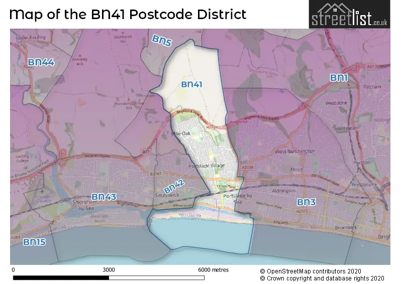
The postcode area has a boundary with The English Channel.
The BN41 Postcode shares a border with BN3 (HOVE) and BN5 (HENFIELD, Small Dole, Woodmancote).
The primary settlement in the BN41 postcode district is Portslade, located in the county of East Sussex. Portslade is associated with the post town of Brighton. Additional significant settlements in the area include Portslade in West Sussex.
For the district BN41, we have data on 3 postcode sectors. Here's a breakdown: The sector BN41 1, covers Portslade in East Sussex. The sector BN41 1, covers Portslade in West Sussex. The sector BN41 2, covers Portslade in East Sussex. The sector BN41 9 is non-geographic. It's often designated for PO Boxes, large organisations, or special services.

Map of the BN41 Postcode District
Explore the BN41 postcode district by using our free interactive map.
When it comes to local government, postal geography often disregards political borders. However, for a breakdown in the BN41 District: the district mostly encompasses the The City of Brighton and Hove (B) (377 postcodes), and finally, the Adur District area (25 postcodes).
Weather Forecast for BN41
Press Button to Show Forecast for Southwick (West Sussex)
| Time Period | Icon | Description | Temperature | Rain Probability | Wind |
|---|---|---|---|---|---|
| 18:00 to 21:00 | Cloudy | 10.0°C (feels like 8.0°C) | 14.00% | WSW 9 mph | |
| 21:00 to 00:00 | Cloudy | 8.0°C (feels like 7.0°C) | 8.00% | N 7 mph |
Press Button to Show Forecast for Southwick (West Sussex)
| Time Period | Icon | Description | Temperature | Rain Probability | Wind |
|---|---|---|---|---|---|
| 00:00 to 03:00 | Cloudy | 7.0°C (feels like 5.0°C) | 7.00% | ENE 7 mph | |
| 03:00 to 06:00 | Cloudy | 7.0°C (feels like 4.0°C) | 9.00% | ENE 7 mph | |
| 06:00 to 09:00 | Overcast | 6.0°C (feels like 4.0°C) | 12.00% | ENE 9 mph | |
| 09:00 to 12:00 | Overcast | 8.0°C (feels like 5.0°C) | 15.00% | E 11 mph | |
| 12:00 to 15:00 | Overcast | 9.0°C (feels like 7.0°C) | 17.00% | E 11 mph | |
| 15:00 to 18:00 | Overcast | 10.0°C (feels like 8.0°C) | 15.00% | ESE 9 mph | |
| 18:00 to 21:00 | Cloudy | 10.0°C (feels like 7.0°C) | 13.00% | E 9 mph | |
| 21:00 to 00:00 | Cloudy | 8.0°C (feels like 5.0°C) | 12.00% | E 11 mph |
Press Button to Show Forecast for Southwick (West Sussex)
| Time Period | Icon | Description | Temperature | Rain Probability | Wind |
|---|---|---|---|---|---|
| 00:00 to 03:00 | Light rain | 8.0°C (feels like 5.0°C) | 47.00% | E 11 mph | |
| 03:00 to 06:00 | Light rain | 8.0°C (feels like 5.0°C) | 50.00% | ENE 11 mph | |
| 06:00 to 09:00 | Cloudy | 8.0°C (feels like 6.0°C) | 18.00% | E 11 mph | |
| 09:00 to 12:00 | Cloudy | 11.0°C (feels like 8.0°C) | 15.00% | ESE 11 mph | |
| 12:00 to 15:00 | Light rain | 12.0°C (feels like 10.0°C) | 50.00% | ESE 11 mph | |
| 15:00 to 18:00 | Cloudy | 13.0°C (feels like 10.0°C) | 25.00% | E 11 mph | |
| 18:00 to 21:00 | Light rain | 12.0°C (feels like 9.0°C) | 49.00% | E 11 mph | |
| 21:00 to 00:00 | Light rain | 11.0°C (feels like 8.0°C) | 48.00% | ENE 11 mph |
Press Button to Show Forecast for Southwick (West Sussex)
| Time Period | Icon | Description | Temperature | Rain Probability | Wind |
|---|---|---|---|---|---|
| 00:00 to 03:00 | Cloudy | 10.0°C (feels like 8.0°C) | 21.00% | E 11 mph | |
| 03:00 to 06:00 | Light rain | 10.0°C (feels like 8.0°C) | 52.00% | E 11 mph | |
| 06:00 to 09:00 | Light rain shower (day) | 10.0°C (feels like 7.0°C) | 39.00% | SE 16 mph | |
| 09:00 to 12:00 | Light rain | 11.0°C (feels like 8.0°C) | 54.00% | SSE 16 mph | |
| 12:00 to 15:00 | Heavy rain shower (day) | 12.0°C (feels like 9.0°C) | 58.00% | S 16 mph | |
| 15:00 to 18:00 | Light rain shower (day) | 13.0°C (feels like 10.0°C) | 38.00% | SSW 16 mph | |
| 18:00 to 21:00 | Light rain shower (day) | 12.0°C (feels like 10.0°C) | 33.00% | SSW 13 mph | |
| 21:00 to 00:00 | Clear night | 11.0°C (feels like 8.0°C) | 7.00% | SW 11 mph |
Where is the BN41 Postcode District?
The postcode district for BN41 is located in Brighton, a town in the South East region of England. Brighton is nearby several other towns, including Hove, Shoreham-by-Sea, Steyning, Hassocks, Henfield, and Lewes. The distance from BN41 to London is approximately 45.4 miles.
The district is within the post town of BRIGHTON.
The sector has postcodes within the nation of England.
The BN41 Postcode District is covers the following regions.
- Brighton and Hove - Surrey, East and West Sussex - South East (England)
- West Sussex (South West) - Surrey, East and West Sussex - South East (England)
| Postcode Sector | Delivery Office |
|---|---|
| BN41 1 | Portslade Delivery Office |
| BN41 2 | Portslade Delivery Office |
| B | N | 4 | 1 | - | X | X | X |
| B | N | 4 | 1 | Space | Numeric | Letter | Letter |
Current Monthly Rental Prices
| # Bedrooms | Min Price | Max Price | Avg Price |
|---|---|---|---|
| £565 | £565 | £565 | |
| 1 | £850 | £1,095 | £973 |
| 2 | £1,500 | £1,650 | £1,575 |
Current House Prices
| # Bedrooms | Min Price | Max Price | Avg Price |
|---|---|---|---|
| 2 | £450,000 | £475,000 | £462,500 |
| 3 | £450,000 | £550,000 | £490,909 |
| 4 | £475,000 | £800,000 | £593,750 |
| 5 | £475,000 | £475,000 | £475,000 |
| 6 | £600,000 | £600,000 | £600,000 |
| 7 | £1,100,000 | £1,100,000 | £1,100,000 |
Estate Agents who Operate in the BN41 District
| Logo | Name | Brand Name | Address | Contact Number | Total Properties |
|---|---|---|---|---|---|
 | Shoreham-By-Sea | Jacobs Steel | 31 Brunswick Road, Shoreham-By-Sea, BN43 5WA | 01273 109739 | 10 |
 | Portslade | Sawyer & Co | 10 Station Road, Portslade, BN41 1GA | 01273 109709 | 9 |
 | Hove | Cox and Co | 61 Boundary Road, BN3 5TD | 01270 433858 | 7 |
 | Hove | Robert Luff & Co | 28 Blatchington Road, Hove, BN3 3YN | 01273 109851 | 5 |
 | Hove | Mishon Mackay | 170 Church Road, Hove, BN3 2DJ | 01273 109769 | 4 |
| Type of Property | 2018 Average | 2018 Sales | 2017 Average | 2017 Sales | 2016 Average | 2016 Sales | 2015 Average | 2015 Sales |
|---|---|---|---|---|---|---|---|---|
| Detached | £377,087 | 31 | £364,644 | 31 | £385,123 | 26 | £334,825 | 44 |
| Semi-Detached | £332,827 | 106 | £320,189 | 115 | £331,295 | 115 | £290,737 | 111 |
| Terraced | £325,503 | 129 | £338,923 | 119 | £334,218 | 129 | £285,163 | 149 |
| Flats | £198,399 | 46 | £229,467 | 59 | £206,044 | 79 | £194,331 | 87 |