The BN6 postcode district is a postal district located in the BN Brighton postcode area with a population of 19,203 residents according to the 2021 England and Wales Census.
The area of the BN6 postcode district is 25.60 square miles which is 66.32 square kilometres or 16,386.82 acres.
Currently, the BN6 district has about 580 postcode units spread across 2 geographic postcode sectors.
Given that each sector allows for 400 unique postcode combinations, the district has a capacity of 800 postcodes. With 580 postcodes already in use, this leaves 220 units available.
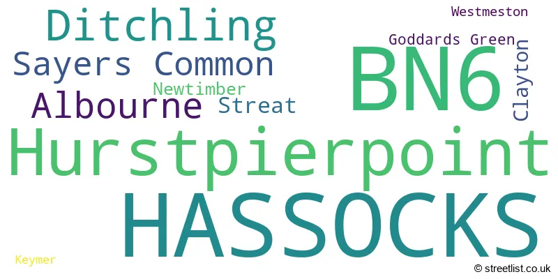
The largest settlement in the BN6 postal code is HASSOCKS followed by Hurstpierpoint, and Ditchling.
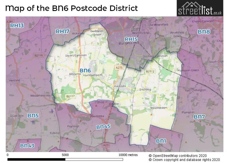
The BN6 Postcode shares a border with BN1 (BRIGHTON, Falmer), RH15 (BURGESS HILL), RH17 (Cuckfield, Balcombe, Ardingly), BN45 (Pyecombe, Poynings, Saddlescombe), BN5 (HENFIELD, Small Dole, Woodmancote) and BN7 (LEWES, Plumpton Green, Kingston).
The primary settlement in the BN6 postcode district is Hassocks, located in West Sussex, England. Additionally, there are other significant settlements within this district, including Ditchling, Keymer, Streat, and Westmeston in East Sussex.
For the district BN6, we have data on 3 postcode sectors. Here's a breakdown: The sector BN6 0 is non-geographic. It's often designated for PO Boxes, large organisations, or special services. The sector BN6 8, covers Hassocks in West Sussex. The sector BN6 8, covers Ditchling in East Sussex. The sector BN6 9, covers Hurstpierpoint and Albourne and Hassocks and Sayers Common in West Sussex.

Map of the BN6 Postcode District
Explore the BN6 postcode district by using our free interactive map.
When it comes to local government, postal geography often disregards political borders. However, for a breakdown in the BN6 District: the district mostly encompasses the Mid Sussex District (519 postcodes), and finally, the Lewes District area (75 postcodes).
Weather Forecast for BN6
Press Button to Show Forecast for Plumpton Racecourse
| Time Period | Icon | Description | Temperature | Rain Probability | Wind |
|---|---|---|---|---|---|
| 09:00 to 12:00 | Partly cloudy (day) | 10.0°C (feels like 8.0°C) | 2.00% | W 9 mph | |
| 12:00 to 15:00 | Overcast | 11.0°C (feels like 9.0°C) | 13.00% | W 11 mph | |
| 15:00 to 18:00 | Light rain shower (day) | 10.0°C (feels like 8.0°C) | 42.00% | W 9 mph | |
| 18:00 to 21:00 | Cloudy | 9.0°C (feels like 8.0°C) | 42.00% | W 7 mph | |
| 21:00 to 00:00 | Cloudy | 7.0°C (feels like 6.0°C) | 9.00% | N 4 mph |
Press Button to Show Forecast for Plumpton Racecourse
| Time Period | Icon | Description | Temperature | Rain Probability | Wind |
|---|---|---|---|---|---|
| 00:00 to 03:00 | Cloudy | 6.0°C (feels like 5.0°C) | 6.00% | NE 4 mph | |
| 03:00 to 06:00 | Cloudy | 6.0°C (feels like 4.0°C) | 7.00% | ENE 7 mph | |
| 06:00 to 09:00 | Cloudy | 6.0°C (feels like 3.0°C) | 10.00% | ENE 7 mph | |
| 09:00 to 12:00 | Overcast | 8.0°C (feels like 5.0°C) | 15.00% | E 9 mph | |
| 12:00 to 15:00 | Overcast | 9.0°C (feels like 7.0°C) | 17.00% | E 9 mph | |
| 15:00 to 18:00 | Overcast | 10.0°C (feels like 8.0°C) | 15.00% | E 9 mph | |
| 18:00 to 21:00 | Cloudy | 9.0°C (feels like 7.0°C) | 13.00% | E 9 mph | |
| 21:00 to 00:00 | Cloudy | 7.0°C (feels like 5.0°C) | 12.00% | E 9 mph |
Press Button to Show Forecast for Plumpton Racecourse
| Time Period | Icon | Description | Temperature | Rain Probability | Wind |
|---|---|---|---|---|---|
| 00:00 to 03:00 | Light rain | 6.0°C (feels like 4.0°C) | 47.00% | ENE 9 mph | |
| 03:00 to 06:00 | Light rain | 7.0°C (feels like 4.0°C) | 50.00% | ENE 9 mph | |
| 06:00 to 09:00 | Overcast | 8.0°C (feels like 5.0°C) | 21.00% | ENE 9 mph | |
| 09:00 to 12:00 | Overcast | 10.0°C (feels like 8.0°C) | 18.00% | E 9 mph | |
| 12:00 to 15:00 | Cloudy | 12.0°C (feels like 10.0°C) | 20.00% | ESE 11 mph | |
| 15:00 to 18:00 | Light rain | 12.0°C (feels like 10.0°C) | 53.00% | ESE 11 mph | |
| 18:00 to 21:00 | Light rain | 11.0°C (feels like 9.0°C) | 51.00% | E 11 mph | |
| 21:00 to 00:00 | Light rain | 10.0°C (feels like 8.0°C) | 48.00% | E 9 mph |
Press Button to Show Forecast for Plumpton Racecourse
| Time Period | Icon | Description | Temperature | Rain Probability | Wind |
|---|---|---|---|---|---|
| 00:00 to 03:00 | Light rain | 10.0°C (feels like 8.0°C) | 51.00% | ENE 9 mph | |
| 03:00 to 06:00 | Light rain shower (night) | 10.0°C (feels like 7.0°C) | 42.00% | ESE 9 mph | |
| 06:00 to 09:00 | Light rain shower (day) | 10.0°C (feels like 7.0°C) | 39.00% | SE 11 mph | |
| 09:00 to 12:00 | Light rain | 11.0°C (feels like 8.0°C) | 52.00% | SSE 13 mph | |
| 12:00 to 15:00 | Heavy rain shower (day) | 12.0°C (feels like 10.0°C) | 57.00% | SSW 16 mph | |
| 15:00 to 18:00 | Light rain shower (day) | 13.0°C (feels like 10.0°C) | 38.00% | SSW 13 mph | |
| 18:00 to 21:00 | Light rain shower (day) | 12.0°C (feels like 10.0°C) | 34.00% | SSW 11 mph | |
| 21:00 to 00:00 | Clear night | 10.0°C (feels like 8.0°C) | 7.00% | SSW 9 mph |
Where is the BN6 Postcode District?
The postcode district BN6 is located in Hassocks. Hassocks is a district town that is situated near several other towns. It is 2.5 miles to the North East of Burgess Hill, 5.2 miles to the South of Brighton, 5.2 miles to the West of Henfield, 5.5 miles to the North of Haywards Heath, 7.4 miles to the South West of Shoreham-by-Sea, and 7.7 miles to the South East of Lewes. Additionally, Hassocks is approximately 40.1 miles away from the centre of London.
The district is within the post town of HASSOCKS.
The sector has postcodes within the nation of England.
The BN6 Postcode District is covers the following regions.
- West Sussex (North East) - Surrey, East and West Sussex - South East (England)
- East Sussex CC - Surrey, East and West Sussex - South East (England)
- Brighton and Hove - Surrey, East and West Sussex - South East (England)
| Postcode Sector | Delivery Office |
|---|---|
| BN6 8 | Hassocks Delivery Office |
| BN6 9 | Hassocks Delivery Office |
| B | N | 6 | - | X | X | X |
| B | N | 6 | Space | Numeric | Letter | Letter |
Tourist Attractions within the Postcode Area
We found 1 visitor attractions within the BN6 postcode area
| Washbrooks Farm Centre |
|---|
| Farms |
| Farm / Rare Breeds / Farm Animals |
| View Washbrooks Farm Centre on Google Maps |
Current Monthly Rental Prices
| # Bedrooms | Min Price | Max Price | Avg Price |
|---|---|---|---|
| 1 | £1,100 | £1,100 | £1,100 |
| 2 | £1,050 | £1,300 | £1,159 |
| 3 | £2,500 | £2,500 | £2,500 |
| 4 | £2,200 | £3,500 | £2,863 |
Current House Prices
| # Bedrooms | Min Price | Max Price | Avg Price |
|---|---|---|---|
| 3 | £850,000 | £850,000 | £850,000 |
| 4 | £800,000 | £1,650,000 | £1,151,818 |
| 5 | £850,000 | £2,250,000 | £1,348,182 |
| 7 | £3,950,000 | £3,950,000 | £3,950,000 |
| 8 | £3,950,000 | £3,950,000 | £3,950,000 |
Estate Agents who Operate in the BN6 District
| Logo | Name | Brand Name | Address | Contact Number | Total Properties |
|---|---|---|---|---|---|
 | Hassocks | Mansell McTaggart | 29 Keymer Road, Hassocks, BN6 8AB | 01273 109855 | 23 |
 | Hurstpierpoint | Mishon Mackay | 106 High Street, Hurstpierpoint, BN6 9PX | 01273 109746 | 18 |
 | Hassocks | Marchants | 1 Keymer Road, Hassocks, BN6 8AE | 01273 109866 | 17 |
 | Hurstpierpoint | Chatt Estates | 133 High Street, Hurstpierpoint, BN6 9PU | 01273 109787 | 12 |
 | Ditchling | Chatt Estates | 34 High Street, Ditchling, BN6 8TA | 01273 109719 | 11 |
| Type of Property | 2018 Average | 2018 Sales | 2017 Average | 2017 Sales | 2016 Average | 2016 Sales | 2015 Average | 2015 Sales |
|---|---|---|---|---|---|---|---|---|
| Detached | £687,395 | 133 | £722,536 | 142 | £632,268 | 116 | £586,172 | 127 |
| Semi-Detached | £447,580 | 100 | £457,766 | 90 | £412,397 | 102 | £424,741 | 100 |
| Terraced | £398,917 | 48 | £380,016 | 31 | £366,941 | 51 | £331,459 | 59 |
| Flats | £221,542 | 32 | £239,178 | 39 | £223,093 | 37 | £204,818 | 31 |