The BS24 postcode district is a postal district located in the BS Bristol postcode area with a population of 24,816 residents according to the 2021 England and Wales Census.
The area of the BS24 postcode district is 20.96 square miles which is 54.28 square kilometres or 13,412.35 acres.
Currently, the BS24 district has about 645 postcode units spread across 5 geographic postcode sectors.
Given that each sector allows for 400 unique postcode combinations, the district has a capacity of 2,000 postcodes. With 645 postcodes already in use, this leaves 1355 units available.
The largest settlement in the BS24 postal code is WESTON-SUPER-MARE followed by Locking, and West Wick.
The postcode area has a boundary with The Bristol Channel.
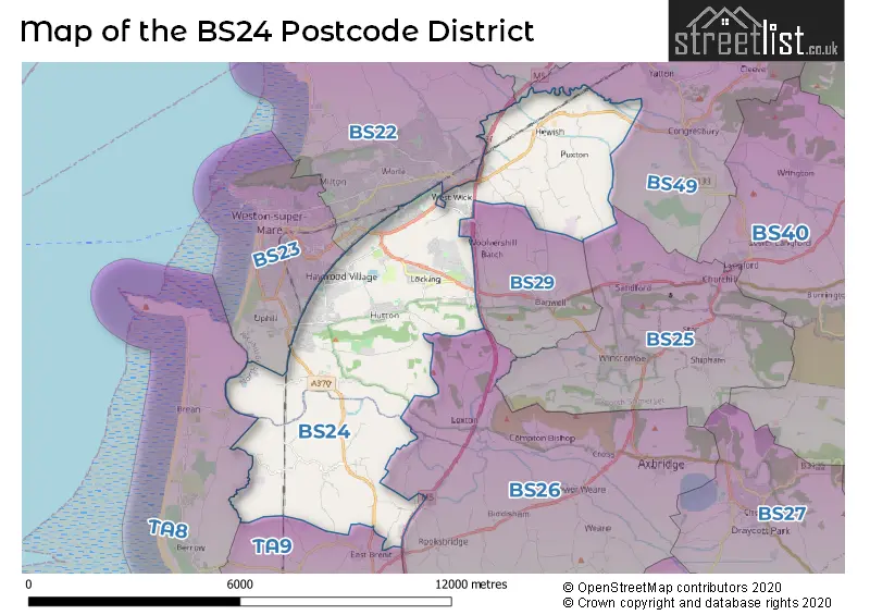
The BS24 Postcode shares a border with BS49 (Yatton, Congresbury, Claverham), BS26 (AXBRIDGE, Rooksbridge, Weare), BS29 (BANWELL), TA9 (HIGHBRIDGE, Mark, West Huntspill), TA8 (BURNHAM-ON-SEA, Berrow, Brean), BS23 (WESTON-SUPER-MARE, Uphill), BS22 (WESTON-SUPER-MARE, St. Georges, Kewstoke) and BS21 (CLEVEDON, Tickenham, Kenn).
In the BS24 postcode district, the primary settlement is Weston-super-Mare, located in the county of Somerset, England. Weston-super-Mare has the highest count of postal addresses in this district. Other significant settlements in this district include Bleadon, Edingworth, Lympsham, East Hewish, Hewish, West Hewish, Locking, West Wick, Elborough, and Hutton. The most significant post town in this district is Weston-super-Mare.
For the district BS24, we have data on 5 postcode sectors. Here's a breakdown: The sector BS24 0, covers Bleadon and Lympsham in Somerset. The sector BS24 6, covers Hewish in Somerset. The sector BS24 7, covers Weston-Super-Mare and Locking and West Wick in Somerset. The sector BS24 8, covers Locking and Weston-Super-Mare in Somerset. The sector BS24 9, covers Weston-Super-Mare and Hutton in Somerset.

Map of the BS24 Postcode District
Explore the BS24 postcode district by using our free interactive map.
When it comes to local government, postal geography often disregards political borders. However, for a breakdown in the BS24 District: the district mostly encompasses the North Somerset (615 postcodes), and finally, the Somerset area (56 postcodes).
Weather Forecast for BS24
Press Button to Show Forecast for Weston-Super-Mare
| Time Period | Icon | Description | Temperature | Rain Probability | Wind |
|---|---|---|---|---|---|
| 15:00 to 18:00 | Cloudy | 11.0°C (feels like 8.0°C) | 4.00% | W 16 mph | |
| 18:00 to 21:00 | Cloudy | 11.0°C (feels like 9.0°C) | 7.00% | WNW 13 mph | |
| 21:00 to 00:00 | Cloudy | 9.0°C (feels like 7.0°C) | 4.00% | NNE 9 mph |
Press Button to Show Forecast for Weston-Super-Mare
| Time Period | Icon | Description | Temperature | Rain Probability | Wind |
|---|---|---|---|---|---|
| 00:00 to 03:00 | Cloudy | 8.0°C (feels like 6.0°C) | 6.00% | NE 7 mph | |
| 03:00 to 06:00 | Cloudy | 7.0°C (feels like 5.0°C) | 6.00% | ENE 7 mph | |
| 06:00 to 09:00 | Cloudy | 7.0°C (feels like 4.0°C) | 7.00% | ENE 9 mph | |
| 09:00 to 12:00 | Cloudy | 8.0°C (feels like 6.0°C) | 9.00% | E 9 mph | |
| 12:00 to 15:00 | Overcast | 10.0°C (feels like 8.0°C) | 17.00% | E 9 mph | |
| 15:00 to 18:00 | Overcast | 10.0°C (feels like 8.0°C) | 18.00% | E 9 mph | |
| 18:00 to 21:00 | Cloudy | 10.0°C (feels like 8.0°C) | 15.00% | E 9 mph | |
| 21:00 to 00:00 | Cloudy | 8.0°C (feels like 6.0°C) | 16.00% | E 7 mph |
Press Button to Show Forecast for Weston-Super-Mare
| Time Period | Icon | Description | Temperature | Rain Probability | Wind |
|---|---|---|---|---|---|
| 00:00 to 03:00 | Cloudy | 8.0°C (feels like 5.0°C) | 15.00% | ENE 9 mph | |
| 03:00 to 06:00 | Overcast | 7.0°C (feels like 4.0°C) | 17.00% | ENE 9 mph | |
| 06:00 to 09:00 | Cloudy | 7.0°C (feels like 3.0°C) | 17.00% | NE 11 mph | |
| 09:00 to 12:00 | Light rain | 8.0°C (feels like 5.0°C) | 48.00% | ENE 13 mph | |
| 12:00 to 15:00 | Cloudy | 10.0°C (feels like 7.0°C) | 18.00% | ENE 13 mph | |
| 15:00 to 18:00 | Cloudy | 11.0°C (feels like 9.0°C) | 16.00% | NE 11 mph | |
| 18:00 to 21:00 | Light rain | 11.0°C (feels like 8.0°C) | 49.00% | NE 11 mph | |
| 21:00 to 00:00 | Light rain | 9.0°C (feels like 7.0°C) | 47.00% | NE 13 mph |
Press Button to Show Forecast for Weston-Super-Mare
| Time Period | Icon | Description | Temperature | Rain Probability | Wind |
|---|---|---|---|---|---|
| 00:00 to 03:00 | Light rain | 9.0°C (feels like 6.0°C) | 49.00% | NE 13 mph | |
| 03:00 to 06:00 | Light rain | 8.0°C (feels like 5.0°C) | 52.00% | NE 13 mph | |
| 06:00 to 09:00 | Heavy rain | 8.0°C (feels like 5.0°C) | 72.00% | NE 11 mph | |
| 09:00 to 12:00 | Light rain | 9.0°C (feels like 7.0°C) | 48.00% | NE 11 mph | |
| 12:00 to 15:00 | Light rain shower (day) | 11.0°C (feels like 9.0°C) | 45.00% | NNE 11 mph | |
| 15:00 to 18:00 | Heavy rain shower (day) | 12.0°C (feels like 9.0°C) | 58.00% | NNW 11 mph | |
| 18:00 to 21:00 | Partly cloudy (day) | 12.0°C (feels like 10.0°C) | 10.00% | NNW 11 mph | |
| 21:00 to 00:00 | Clear night | 10.0°C (feels like 8.0°C) | 6.00% | NNE 9 mph |
Where is the BS24 Postcode District?
The data postcode district for BS24 is located in Weston-super-Mare. It is surrounded by nearby towns such as Banwell to the East (2.06 miles away), Axbridge to the South East (5.47 miles away), Burnham-on-Sea to the South West (6.40 miles away), Highbridge to the South (7.14 miles away), and Clevedon to the North East (8.38 miles away). Additionally, the distance between the postcode district and the center of London is approximately 121.34 miles.
The district is within the post town of WESTON-SUPER-MARE.
The sector has postcodes within the nation of England.
The BS24 Postcode District is covers the following regions.
- Bath and North East Somerset, North Somerset and South Gloucestershire - Gloucestershire, Wiltshire and Bath/Bristol area - South West (England)
- Somerset - Dorset and Somerset - South West (England)
| Postcode Sector | Delivery Office |
|---|---|
| BS24 0 | Weston Super Mare Delivery Office |
| BS24 6 | Weston Super Mare Delivery Office |
| BS24 7 | Weston Super Mare Delivery Office |
| BS24 8 | Weston Super Mare Delivery Office |
| BS24 9 | Weston Super Mare Delivery Office |
| B | S | 2 | 4 | - | X | X | X |
| B | S | 2 | 4 | Space | Numeric | Letter | Letter |
Tourist Attractions within the Postcode Area
We found 2 visitor attractions within the BS24 postcode area
| The Helicopter Museum |
|---|
| Museums & Art Galleries |
| Museum and / or Art Gallery |
| View The Helicopter Museum on Google Maps |
| Trelissick Gardens |
| Gardens |
| Garden |
| View Trelissick Gardens on Google Maps |
Current Monthly Rental Prices
| # Bedrooms | Min Price | Max Price | Avg Price |
|---|---|---|---|
| £1,250 | £1,417 | £1,334 | |
| 1 | £795 | £795 | £795 |
| 3 | £1,250 | £1,250 | £1,250 |
Current House Prices
| # Bedrooms | Min Price | Max Price | Avg Price |
|---|---|---|---|
| £1,200,000 | £1,200,000 | £1,200,000 | |
| 2 | £900,000 | £900,000 | £900,000 |
| 3 | £1,200,000 | £1,200,000 | £1,200,000 |
| 4 | £600,000 | £895,000 | £700,829 |
| 5 | £625,000 | £850,000 | £743,750 |
| 6 | £1,100,000 | £2,775,000 | £2,216,667 |
| 7 | £995,000 | £995,000 | £995,000 |
| 8 | £900,000 | £1,150,000 | £1,025,000 |
Estate Agents who Operate in the BS24 District
| Logo | Name | Brand Name | Address | Contact Number | Total Properties |
|---|---|---|---|---|---|
 | Weston Super Mare | Ashley Leahy Estate Agents | 306 Park Way Worle Weston-Super-Mare BS22 6WA | 01934 315041 | 28 |
 | Weston-Super-Mare | House Fox Estate Agents | Suite 42, Pure Offices Pastures Avenue St. Georges Weston-Super-Mare BS22 7SB | 01934 315067 | 24 |
 | Worle | Palmer Snell | 181 High Street, Worle, Weston-Super-Mare, Somerset, BS22 0JS | 01934 315044 | 21 |
 | Weston Super Mare | Saxons Estate Agents | 21 Boulevard Weston-Super-Mare BS23 1NR | 01934 315066 | 18 |
 | Weston Super Mare | David Plaister Ltd | 12 South Parade, Weston-super-Mare, North Somerset, BS23 1JN | 01934 317536 | 16 |
| Type of Property | 2018 Average | 2018 Sales | 2017 Average | 2017 Sales | 2016 Average | 2016 Sales | 2015 Average | 2015 Sales |
|---|---|---|---|---|---|---|---|---|
| Detached | £317,273 | 185 | £311,337 | 219 | £294,161 | 222 | £262,447 | 207 |
| Semi-Detached | £218,222 | 220 | £213,313 | 203 | £198,900 | 224 | £186,992 | 217 |
| Terraced | £194,057 | 211 | £192,764 | 177 | £178,512 | 184 | £163,130 | 200 |
| Flats | £143,968 | 87 | £146,906 | 92 | £129,160 | 55 | £119,383 | 30 |