The BS35 postcode district is a postal district located in the BS Bristol postcode area with a population of 24,401 residents according to the 2021 England and Wales Census.
The area of the BS35 postcode district is 35.59 square miles which is 92.17 square kilometres or 22,775.84 acres.
Currently, the BS35 district has about 775 postcode units spread across 5 geographic postcode sectors.
Given that each sector allows for 400 unique postcode combinations, the district has a capacity of 2,000 postcodes. With 775 postcodes already in use, this leaves 1225 units available.
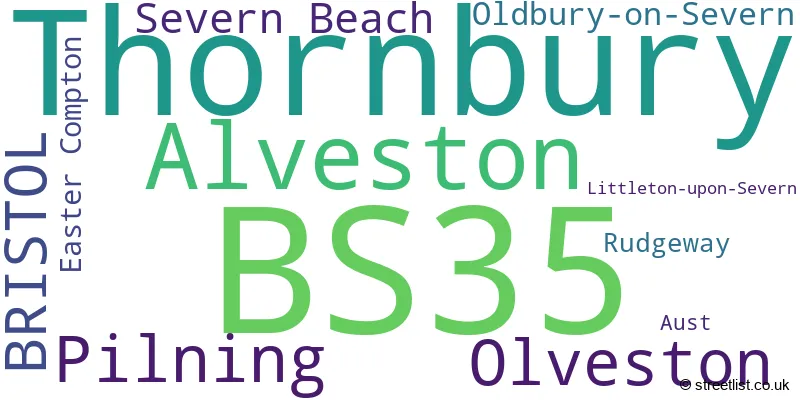
The largest settlement in the BS35 postal code is Thornbury followed by Alveston, and Severn Beach.
The postcode area has a boundary with The Bristol Channel.
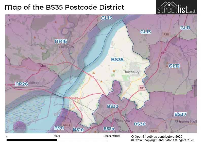
The BS35 Postcode shares a border with GL12 (WOTTON-UNDER-EDGE, Charfield, Wickwar), BS36 (Frampton Cotterell, Winterbourne, Coalpit Heath), BS37 (Yate, Chipping Sodbury, Iron Acton), BS10 (BRISTOL, Westbury-on-Trym, Henbury), BS32 (Bradley Stoke, Almondsbury, Tockington) and NP16 (CHEPSTOW, BULWARK, Tutshill).
The primary settlement in the BS35 postcode district is Thornbury, located in the county of Gloucestershire. Other significant settlements include Littleton-upon-Severn, Oldbury-on-Severn, Alveston, Rudgeway, Aust, Olveston, Pilning, Severn Beach, and Easter Compton. The post town for the BS35 postcode district is Bristol.
For the district BS35, we have data on 6 postcode sectors. Here's a breakdown: The sector BS35 1, covers Thornbury and Oldbury-On-Severn in Gloucestershire. The sector BS35 2, covers Thornbury in Gloucestershire. The sector BS35 3, covers Alveston and Thornbury and Rudgeway in Gloucestershire. The sector BS35 4, covers Pilning and Olveston and Severn Beach in Gloucestershire. The sector BS35 5, covers Easter Compton in Gloucestershire. The sector BS35 9 is non-geographic. It's often designated for PO Boxes, large organisations, or special services.

Map of the BS35 Postcode District
Explore the BS35 postcode district by using our free interactive map.
When it comes to local government, postal geography often disregards political borders. However, for a breakdown in the BS35 District: the district mostly encompasses the South Gloucestershire area with a total of 757 postcodes.
Weather Forecast for BS35
Press Button to Show Forecast for Thornbury
| Time Period | Icon | Description | Temperature | Rain Probability | Wind |
|---|---|---|---|---|---|
| 12:00 to 15:00 | Cloudy | 12.0°C (feels like 9.0°C) | 7.00% | NW 16 mph | |
| 15:00 to 18:00 | Cloudy | 12.0°C (feels like 9.0°C) | 27.00% | NW 16 mph | |
| 18:00 to 21:00 | Partly cloudy (day) | 10.0°C (feels like 8.0°C) | 2.00% | N 11 mph | |
| 21:00 to 00:00 | Clear night | 7.0°C (feels like 4.0°C) | 0.00% | NW 9 mph |
Press Button to Show Forecast for Thornbury
| Time Period | Icon | Description | Temperature | Rain Probability | Wind |
|---|---|---|---|---|---|
| 00:00 to 03:00 | Clear night | 6.0°C (feels like 2.0°C) | 4.00% | NW 9 mph | |
| 03:00 to 06:00 | Partly cloudy (night) | 6.0°C (feels like 2.0°C) | 4.00% | NW 11 mph | |
| 06:00 to 09:00 | Sunny day | 5.0°C (feels like 2.0°C) | 0.00% | NW 11 mph | |
| 09:00 to 12:00 | Cloudy | 8.0°C (feels like 4.0°C) | 3.00% | NNW 13 mph | |
| 12:00 to 15:00 | Overcast | 10.0°C (feels like 7.0°C) | 10.00% | NW 13 mph | |
| 15:00 to 18:00 | Cloudy | 10.0°C (feels like 7.0°C) | 11.00% | NW 13 mph | |
| 18:00 to 21:00 | Overcast | 8.0°C (feels like 6.0°C) | 17.00% | NW 11 mph | |
| 21:00 to 00:00 | Partly cloudy (night) | 6.0°C (feels like 4.0°C) | 11.00% | NW 7 mph |
Press Button to Show Forecast for Thornbury
| Time Period | Icon | Description | Temperature | Rain Probability | Wind |
|---|---|---|---|---|---|
| 00:00 to 03:00 | Clear night | 4.0°C (feels like 2.0°C) | 3.00% | N 7 mph | |
| 03:00 to 06:00 | Clear night | 3.0°C (feels like 1.0°C) | 2.00% | N 4 mph | |
| 06:00 to 09:00 | Sunny day | 3.0°C (feels like 1.0°C) | 4.00% | NNE 4 mph | |
| 09:00 to 12:00 | Sunny day | 8.0°C (feels like 6.0°C) | 2.00% | N 4 mph | |
| 12:00 to 15:00 | Cloudy | 11.0°C (feels like 10.0°C) | 6.00% | WNW 4 mph | |
| 15:00 to 18:00 | Cloudy | 12.0°C (feels like 10.0°C) | 8.00% | W 9 mph | |
| 18:00 to 21:00 | Cloudy | 10.0°C (feels like 8.0°C) | 8.00% | W 11 mph | |
| 21:00 to 00:00 | Cloudy | 8.0°C (feels like 6.0°C) | 6.00% | WSW 11 mph |
Press Button to Show Forecast for Thornbury
| Time Period | Icon | Description | Temperature | Rain Probability | Wind |
|---|---|---|---|---|---|
| 00:00 to 03:00 | Cloudy | 9.0°C (feels like 6.0°C) | 8.00% | W 11 mph | |
| 03:00 to 06:00 | Cloudy | 9.0°C (feels like 6.0°C) | 6.00% | W 11 mph | |
| 06:00 to 09:00 | Cloudy | 9.0°C (feels like 6.0°C) | 6.00% | WNW 11 mph | |
| 09:00 to 12:00 | Cloudy | 11.0°C (feels like 8.0°C) | 6.00% | NW 16 mph | |
| 12:00 to 15:00 | Overcast | 12.0°C (feels like 10.0°C) | 8.00% | NW 16 mph | |
| 15:00 to 18:00 | Cloudy | 13.0°C (feels like 10.0°C) | 5.00% | NW 16 mph | |
| 18:00 to 21:00 | Partly cloudy (day) | 11.0°C (feels like 9.0°C) | 2.00% | NNW 11 mph | |
| 21:00 to 00:00 | Clear night | 9.0°C (feels like 6.0°C) | 2.00% | NNW 9 mph |
Press Button to Show Forecast for Thornbury
| Time Period | Icon | Description | Temperature | Rain Probability | Wind |
|---|---|---|---|---|---|
| 00:00 to 03:00 | Partly cloudy (night) | 7.0°C (feels like 4.0°C) | 2.00% | NNW 7 mph | |
| 03:00 to 06:00 | Partly cloudy (night) | 5.0°C (feels like 3.0°C) | 2.00% | N 7 mph | |
| 06:00 to 09:00 | Sunny day | 6.0°C (feels like 4.0°C) | 2.00% | N 4 mph | |
| 09:00 to 12:00 | Sunny day | 9.0°C (feels like 8.0°C) | 1.00% | NNE 7 mph | |
| 12:00 to 15:00 | Partly cloudy (day) | 12.0°C (feels like 10.0°C) | 2.00% | N 7 mph | |
| 15:00 to 18:00 | Partly cloudy (day) | 13.0°C (feels like 12.0°C) | 2.00% | N 7 mph | |
| 18:00 to 21:00 | Sunny day | 12.0°C (feels like 11.0°C) | 1.00% | N 4 mph | |
| 21:00 to 00:00 | Clear night | 8.0°C (feels like 6.0°C) | 1.00% | NNE 4 mph |
Where is the BS35 Postcode District?
The data's postcode district, BS35, is located in the town of Bristol. Bristol is surrounded by several nearby towns. In the North West direction, there is Chepstow, which is approximately 5.6 miles away. Moving towards the West, there is Caldicot at a distance of about 8.3 miles. To the North East, you will find Berkeley, which is around 8.4 miles away. Heading North, the town of Lydney is about 9 miles away. Lastly, in the East direction, you will come across Wotton-under-Edge, which is approximately 9.7 miles away. Additionally, the distance between the postcode district and London's center is around 105.4 miles.
The district is within the post town of BRISTOL.
The sector has postcodes within the nation of England.
The BS35 Postcode District is in the Bath and North East Somerset, North Somerset and South Gloucestershire region of Gloucestershire, Wiltshire and Bath/Bristol area within the South West (England).
| Postcode Sector | Delivery Office |
|---|---|
| BS35 1 | Thornbury Delivery Office |
| BS35 2 | Thornbury Delivery Office |
| BS35 3 | Thornbury Delivery Office |
| BS35 4 | Pilning Scale Payment Delivery Office |
| BS35 5 | Easter Compton Scale Payment Delivery Office |
| B | S | 3 | 5 | - | X | X | X |
| B | S | 3 | 5 | Space | Numeric | Letter | Letter |
Tourist Attractions within the Postcode Area
We found 1 visitor attractions within the BS35 postcode area
| Thornbury and District Museum |
|---|
| Museums & Art Galleries |
| Museum and / or Art Gallery |
| View Thornbury and District Museum on Google Maps |
Current Monthly Rental Prices
| # Bedrooms | Min Price | Max Price | Avg Price |
|---|---|---|---|
| 2 | £1,100 | £1,400 | £1,250 |
| 3 | £1,300 | £2,500 | £1,690 |
| 4 | £1,795 | £1,795 | £1,795 |
Current House Prices
| # Bedrooms | Min Price | Max Price | Avg Price |
|---|---|---|---|
| £1,250,000 | £1,250,000 | £1,250,000 | |
| 3 | £795,000 | £875,000 | £835,000 |
| 4 | £670,000 | £1,600,000 | £902,042 |
| 5 | £775,000 | £2,500,000 | £1,337,500 |
| 6 | £950,000 | £950,000 | £950,000 |
| 7 | £1,300,000 | £1,300,000 | £1,300,000 |
| 8 | £1,275,000 | £1,275,000 | £1,275,000 |
Estate Agents who Operate in the BS35 District
| Logo | Name | Brand Name | Address | Contact Number | Total Properties |
|---|---|---|---|---|---|
 | Thornbury | Lisa Costa Residential Sales & Lettings | 53 High Street, Thornbury, BS35 2AR | 01454 800949 | 37 |
 | Thornbury | Milburys | 61 High Street, Thornbury, BS35 2AP | 01454 801767 | 33 |
 | Thornbury | Hunters | 57 High Street, Thornbury, BS35 2AP | 01454 803924 | 22 |
 | Thornbury | Bonds Of Thornbury | 14 The Plain, Thornbury, Bristol, BS35 2BD | 01454 802518 | 12 |
 | Bristol | Severnside Estate Agents Ltd | 115 Beach Road, Severn Beach, Bristol BS35 4PQ | 01454 804755 | 6 |
- Alveston
- Aust
- Avonmouth
- Awkley
- Compton Greenfield
- Cowhill
- Crossways
- Earthcott Green
- Easter Compton
- Elberton
- Grovesend
- Ingst
- Itchington
- Kington
- Latteridge
- Littleton-upon-Severn
- Lower Hazel
- Lower Morton
- Marsh Common
- New Passage
- Old Down
- Old Passage
- Oldbury Naite
- Oldbury-on-Severn
- Olveston
- Pilning
- Redwick
- Rudgeway
- Severn Beach
- Shepperdine
- The Hacket
- Thornbury
- Tockington
- Upper Morton
- Woodhouse Down
| Type of Property | 2018 Average | 2018 Sales | 2017 Average | 2017 Sales | 2016 Average | 2016 Sales | 2015 Average | 2015 Sales |
|---|---|---|---|---|---|---|---|---|
| Detached | £455,289 | 175 | £442,150 | 153 | £418,867 | 153 | £380,028 | 155 |
| Semi-Detached | £300,143 | 182 | £288,600 | 108 | £282,336 | 114 | £259,817 | 129 |
| Terraced | £270,268 | 122 | £264,530 | 118 | £249,280 | 92 | £211,693 | 109 |
| Flats | £170,327 | 32 | £189,303 | 39 | £175,966 | 38 | £188,128 | 66 |
Hotels within the Postcode Area
We found 5 hotels and guest houses within the BS35 postcode area
Thornbury Castle
Castle Street, Thornbury, Thornbury Nr Bristol, thornbury-aireborough, BS35 1HH.
View detailsThe Barn at Freemans Farm B&B
Freemans Farm Itchington Alveston Bristol BS35 3TL, Alveston, alveston, BS35 3TL.
View details