The BS37 postcode district is a postal district located in the BS Bristol postcode area with a population of 40,910 residents according to the 2021 England and Wales Census.
The area of the BS37 postcode district is 34.73 square miles which is 89.96 square kilometres or 22,228.85 acres.
Currently, the BS37 district has about 962 postcode units spread across 6 geographic postcode sectors.
Given that each sector allows for 400 unique postcode combinations, the district has a capacity of 2,400 postcodes. With 962 postcodes already in use, this leaves 1438 units available.
The largest settlement in the BS37 postal code is Yate followed by Chipping Sodbury, and Iron Acton.
The BS37 Postcode shares a border with GL12 (WOTTON-UNDER-EDGE, Charfield, Wickwar), BS36 (Frampton Cotterell, Winterbourne, Coalpit Heath), GL9 (Hawkesbury Upton, BADMINTON, Acton Turville), BS16 (BRISTOL, Emersons Green, Mangotsfield), SN14 (CHIPPENHAM, Colerne, Marshfield) and BS35 (Thornbury, Alveston, Severn Beach).
In the BS37 postcode district in Gloucestershire, the primary settlement is Yate, which has the highest count. Other significant settlements in this district include Chipping Sodbury, Horton, Old Sodbury, Rangeworthy, Westerleigh, and Iron Acton. The main post town for this district is Bristol.
For the district BS37, we have data on 7 postcode sectors. Here's a breakdown: The sector BS37 0 is non-geographic. It's often designated for PO Boxes, large organisations, or special services. The sector BS37 4, covers Yate in Gloucestershire. The sector BS37 5, covers Yate in Gloucestershire. The sector BS37 6, covers Chipping Sodbury and Old Sodbury in Gloucestershire. The sector BS37 7, covers Yate and Rangeworthy in Gloucestershire. The sector BS37 8, covers Yate and Westerleigh in Gloucestershire. The sector BS37 9, covers Iron Acton in Gloucestershire.

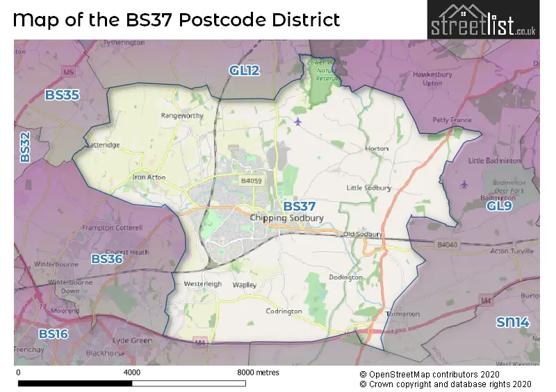
Map of the BS37 Postcode District
Explore the BS37 postcode district by using our free interactive map.
When it comes to local government, postal geography often disregards political borders. However, for a breakdown in the BS37 District: the district mostly encompasses the South Gloucestershire area with a total of 1030 postcodes.
Weather Forecast for BS37
Press Button to Show Forecast for Chipping Sodbury
| Time Period | Icon | Description | Temperature | Rain Probability | Wind |
|---|---|---|---|---|---|
| 06:00 to 09:00 | Cloudy | 5.0°C (feels like 4.0°C) | 4.00% | SW 4 mph | |
| 09:00 to 12:00 | Light rain shower (day) | 8.0°C (feels like 6.0°C) | 28.00% | W 9 mph | |
| 12:00 to 15:00 | Cloudy | 11.0°C (feels like 9.0°C) | 10.00% | WNW 9 mph | |
| 15:00 to 18:00 | Cloudy | 11.0°C (feels like 9.0°C) | 7.00% | WNW 9 mph | |
| 18:00 to 21:00 | Cloudy | 10.0°C (feels like 9.0°C) | 6.00% | N 7 mph | |
| 21:00 to 00:00 | Cloudy | 8.0°C (feels like 6.0°C) | 7.00% | NE 7 mph |
Press Button to Show Forecast for Chipping Sodbury
| Time Period | Icon | Description | Temperature | Rain Probability | Wind |
|---|---|---|---|---|---|
| 00:00 to 03:00 | Cloudy | 6.0°C (feels like 5.0°C) | 4.00% | ENE 4 mph | |
| 03:00 to 06:00 | Cloudy | 5.0°C (feels like 3.0°C) | 6.00% | ENE 7 mph | |
| 06:00 to 09:00 | Overcast | 5.0°C (feels like 3.0°C) | 10.00% | ENE 7 mph | |
| 09:00 to 12:00 | Cloudy | 7.0°C (feels like 5.0°C) | 9.00% | E 9 mph | |
| 12:00 to 15:00 | Overcast | 9.0°C (feels like 7.0°C) | 14.00% | E 9 mph | |
| 15:00 to 18:00 | Overcast | 10.0°C (feels like 8.0°C) | 18.00% | E 9 mph | |
| 18:00 to 21:00 | Overcast | 9.0°C (feels like 7.0°C) | 19.00% | ENE 7 mph | |
| 21:00 to 00:00 | Cloudy | 7.0°C (feels like 5.0°C) | 16.00% | E 7 mph |
Press Button to Show Forecast for Chipping Sodbury
| Time Period | Icon | Description | Temperature | Rain Probability | Wind |
|---|---|---|---|---|---|
| 00:00 to 03:00 | Cloudy | 6.0°C (feels like 4.0°C) | 13.00% | ENE 7 mph | |
| 03:00 to 06:00 | Cloudy | 5.0°C (feels like 3.0°C) | 17.00% | ENE 9 mph | |
| 06:00 to 09:00 | Overcast | 5.0°C (feels like 2.0°C) | 26.00% | ENE 9 mph | |
| 09:00 to 12:00 | Light rain | 7.0°C (feels like 5.0°C) | 51.00% | ENE 11 mph | |
| 12:00 to 15:00 | Overcast | 9.0°C (feels like 7.0°C) | 21.00% | ENE 11 mph | |
| 15:00 to 18:00 | Cloudy | 11.0°C (feels like 8.0°C) | 18.00% | ENE 11 mph | |
| 18:00 to 21:00 | Light rain | 10.0°C (feels like 8.0°C) | 51.00% | NE 9 mph | |
| 21:00 to 00:00 | Light rain | 8.0°C (feels like 6.0°C) | 52.00% | NE 11 mph |
Press Button to Show Forecast for Chipping Sodbury
| Time Period | Icon | Description | Temperature | Rain Probability | Wind |
|---|---|---|---|---|---|
| 00:00 to 03:00 | Light rain | 7.0°C (feels like 5.0°C) | 50.00% | NE 9 mph | |
| 03:00 to 06:00 | Heavy rain | 7.0°C (feels like 4.0°C) | 72.00% | NE 9 mph | |
| 06:00 to 09:00 | Light rain | 7.0°C (feels like 4.0°C) | 53.00% | NE 9 mph | |
| 09:00 to 12:00 | Heavy rain | 9.0°C (feels like 6.0°C) | 72.00% | NNE 9 mph | |
| 12:00 to 15:00 | Light rain shower (day) | 11.0°C (feels like 8.0°C) | 42.00% | WNW 11 mph | |
| 15:00 to 18:00 | Light rain shower (day) | 11.0°C (feels like 9.0°C) | 43.00% | NW 11 mph | |
| 18:00 to 21:00 | Light rain shower (day) | 11.0°C (feels like 9.0°C) | 34.00% | S 9 mph | |
| 21:00 to 00:00 | Clear night | 8.0°C (feels like 6.0°C) | 5.00% | SW 7 mph |
Where is the BS37 Postcode District?
The postcode district for BS37 is located in the town of Bristol. Bristol is surrounded by several nearby towns, including Badminton to the East (3.92 miles away), Wotton-under-Edge to the North (6.18 miles away), Chippenham to the South East (10.34 miles away), Bath to the South (11.01 miles away), and Tetbury to the North East (12.04 miles away). Additionally, Bristol is approximately 97.86 miles away from the centre of London.
The district is within the post town of BRISTOL.
The sector has postcodes within the nation of England.
The BS37 Postcode District is in the Bath and North East Somerset, North Somerset and South Gloucestershire region of Gloucestershire, Wiltshire and Bath/Bristol area within the South West (England).
| Postcode Sector | Delivery Office |
|---|---|
| BS37 4 | Yate Delivery Office |
| BS37 5 | Yate Delivery Office |
| BS37 6 | Yate Delivery Office |
| BS37 7 | Yate Delivery Office |
| BS37 8 | Yate Delivery Office |
| BS37 9 | Yate Delivery Office |
| B | S | 3 | 7 | - | X | X | X |
| B | S | 3 | 7 | Space | Numeric | Letter | Letter |
Current Monthly Rental Prices
| # Bedrooms | Min Price | Max Price | Avg Price |
|---|---|---|---|
| £85 | £85 | £85 | |
| 1 | £600 | £725 | £670 |
| 2 | £950 | £1,100 | £1,025 |
| 3 | £1,320 | £2,500 | £1,654 |
Current House Prices
| # Bedrooms | Min Price | Max Price | Avg Price |
|---|---|---|---|
| 3 | £600,000 | £625,000 | £612,500 |
| 4 | £599,950 | £875,000 | £714,935 |
| 5 | £600,000 | £1,395,000 | £833,000 |
| 6 | £1,495,000 | £1,495,000 | £1,495,000 |
Estate Agents who Operate in the BS37 District
| Logo | Name | Brand Name | Address | Contact Number | Total Properties |
|---|---|---|---|---|---|
 | Yate | Taylors Estate Agents | 94 Station Road, Yate, Bristol, BS37 4PH | 01454 802519 | 46 |
 | Chipping Sodbury | Milburys | 52, High Street, Chipping Sodbury, BS37 6AH | 01454 802024 | 27 |
 | Yate | Hunters | 80-82 Station Road Yate BS37 4PH | 01454 802649 | 18 |
 | Yate | Andrews Estate Agents | 84 Station Road Yate BS37 4PH | 01454 802685 | 14 |
 | Chipping Sodbury | Bundy & Bond Independent Estate Agents | Unit 2 Rounceval Mews Chipping Sodbury BS37 6AS | 01454 802078 | 12 |
| Type of Property | 2018 Average | 2018 Sales | 2017 Average | 2017 Sales | 2016 Average | 2016 Sales | 2015 Average | 2015 Sales |
|---|---|---|---|---|---|---|---|---|
| Detached | £425,236 | 122 | £396,280 | 182 | £368,673 | 218 | £343,600 | 150 |
| Semi-Detached | £270,221 | 175 | £263,016 | 229 | £247,868 | 216 | £229,163 | 176 |
| Terraced | £222,770 | 201 | £215,557 | 299 | £210,025 | 293 | £191,418 | 281 |
| Flats | £170,721 | 71 | £157,787 | 74 | £176,118 | 97 | £199,769 | 139 |