The BS39 postcode district is a postal district located in the BS Bristol postcode area with a population of 17,349 residents according to the 2021 England and Wales Census.
The area of the BS39 postcode district is 28.26 square miles which is 73.19 square kilometres or 18,086.03 acres.
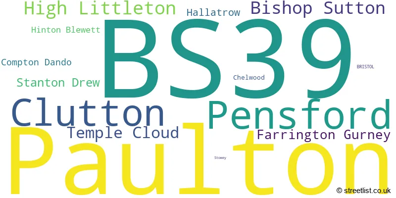
Currently, the BS39 district has about 622 postcode units spread across 4 geographic postcode sectors.
Given that each sector allows for 400 unique postcode combinations, the district has a capacity of 1,600 postcodes. With 622 postcodes already in use, this leaves 978 units available.
The largest settlement in the BS39 postal code is Paulton followed by Pensford, and Clutton.
The BS39 Postcode shares a border with BA2 (BATH, Peasedown St. John, Timsbury), BS14 (BRISTOL, Whitchurch), BS31 (Keynsham, Saltford), BA3 (Midsomer Norton, Westfield, RADSTOCK) and BS40 (Wrington, Langford, Winford).
In the BS39 postcode district, the primary settlement with the highest count is Pensford, located in the county of Somerset in England. Other significant settlements in the district include Compton Dando, Stanton Drew, and Chelwood, all also located in Somerset. The main post town in the district is Bristol.
For the district BS39, we have data on 4 postcode sectors. Here's a breakdown: The sector BS39 4, covers Pensford and Stanton Drew and Compton Dando in Somerset. The sector BS39 5, covers Clutton and Bishop Sutton and Temple Cloud in Somerset. The sector BS39 6, covers High Littleton and Farrington Gurney and Hallatrow in Somerset. The sector BS39 7, covers Paulton in Somerset.

Map of the BS39 Postcode District
Explore the BS39 postcode district by using our free interactive map.

When it comes to local government, postal geography often disregards political borders. However, for a breakdown in the BS39 District: the district mostly encompasses the Bath and North East Somerset area with a total of 626 postcodes.
Weather Forecast for BS39
Press Button to Show Forecast for Midsomer Norton
| Time Period | Icon | Description | Temperature | Rain Probability | Wind |
|---|---|---|---|---|---|
| 00:00 to 03:00 | Cloudy | 7.0°C (feels like 5.0°C) | 4.00% | NE 7 mph | |
| 03:00 to 06:00 | Cloudy | 4.0°C (feels like 2.0°C) | 3.00% | N 2 mph | |
| 06:00 to 09:00 | Cloudy | 5.0°C (feels like 4.0°C) | 4.00% | NNW 2 mph | |
| 09:00 to 12:00 | Cloudy | 8.0°C (feels like 7.0°C) | 6.00% | NNE 4 mph | |
| 12:00 to 15:00 | Cloudy | 11.0°C (feels like 9.0°C) | 4.00% | N 7 mph | |
| 15:00 to 18:00 | Overcast | 12.0°C (feels like 10.0°C) | 7.00% | N 7 mph | |
| 18:00 to 21:00 | Cloudy | 11.0°C (feels like 10.0°C) | 4.00% | NNW 7 mph | |
| 21:00 to 00:00 | Cloudy | 8.0°C (feels like 7.0°C) | 7.00% | N 4 mph |
Press Button to Show Forecast for Midsomer Norton
| Time Period | Icon | Description | Temperature | Rain Probability | Wind |
|---|---|---|---|---|---|
| 00:00 to 03:00 | Cloudy | 6.0°C (feels like 5.0°C) | 4.00% | E 4 mph | |
| 03:00 to 06:00 | Clear night | 4.0°C (feels like 3.0°C) | 1.00% | NNW 2 mph | |
| 06:00 to 09:00 | Partly cloudy (day) | 5.0°C (feels like 4.0°C) | 1.00% | NNE 4 mph | |
| 09:00 to 12:00 | Partly cloudy (day) | 8.0°C (feels like 6.0°C) | 1.00% | NNE 7 mph | |
| 12:00 to 15:00 | Overcast | 10.0°C (feels like 8.0°C) | 7.00% | NNE 9 mph | |
| 15:00 to 18:00 | Overcast | 11.0°C (feels like 9.0°C) | 8.00% | NNE 11 mph | |
| 18:00 to 21:00 | Cloudy | 10.0°C (feels like 8.0°C) | 7.00% | NE 9 mph | |
| 21:00 to 00:00 | Partly cloudy (night) | 7.0°C (feels like 5.0°C) | 2.00% | NE 7 mph |
Press Button to Show Forecast for Midsomer Norton
| Time Period | Icon | Description | Temperature | Rain Probability | Wind |
|---|---|---|---|---|---|
| 00:00 to 03:00 | Partly cloudy (night) | 6.0°C (feels like 3.0°C) | 3.00% | NE 7 mph | |
| 03:00 to 06:00 | Clear night | 4.0°C (feels like 2.0°C) | 2.00% | NE 4 mph | |
| 06:00 to 09:00 | Cloudy | 4.0°C (feels like 2.0°C) | 7.00% | NNE 4 mph | |
| 09:00 to 12:00 | Cloudy | 8.0°C (feels like 6.0°C) | 8.00% | NE 7 mph | |
| 12:00 to 15:00 | Overcast | 9.0°C (feels like 8.0°C) | 15.00% | N 7 mph | |
| 15:00 to 18:00 | Cloudy | 9.0°C (feels like 8.0°C) | 18.00% | N 7 mph | |
| 18:00 to 21:00 | Cloudy | 9.0°C (feels like 7.0°C) | 15.00% | NNE 7 mph | |
| 21:00 to 00:00 | Overcast | 7.0°C (feels like 6.0°C) | 11.00% | NNE 7 mph |
Press Button to Show Forecast for Midsomer Norton
| Time Period | Icon | Description | Temperature | Rain Probability | Wind |
|---|---|---|---|---|---|
| 00:00 to 03:00 | Cloudy | 6.0°C (feels like 5.0°C) | 8.00% | NNE 4 mph | |
| 03:00 to 06:00 | Cloudy | 5.0°C (feels like 4.0°C) | 6.00% | NE 4 mph | |
| 06:00 to 09:00 | Cloudy | 6.0°C (feels like 4.0°C) | 6.00% | N 4 mph | |
| 09:00 to 12:00 | Overcast | 9.0°C (feels like 7.0°C) | 10.00% | N 7 mph | |
| 12:00 to 15:00 | Cloudy | 11.0°C (feels like 9.0°C) | 8.00% | N 9 mph | |
| 15:00 to 18:00 | Cloudy | 12.0°C (feels like 10.0°C) | 10.00% | N 9 mph | |
| 18:00 to 21:00 | Cloudy | 11.0°C (feels like 10.0°C) | 6.00% | N 7 mph | |
| 21:00 to 00:00 | Cloudy | 8.0°C (feels like 7.0°C) | 5.00% | N 7 mph |
Where is the BS39 Postcode District?
The postcode district of BS39 is located in Bristol. It is in close proximity to several nearby towns. To the South East, there is Radstock, which is approximately 5.5 miles away. To the East, there is Bath, which is around 7.6 miles away. Wells is located to the South, at a distance of approximately 10.1 miles. Cheddar can be found in the South West, approximately 11.1 miles away. Lastly, to the West, there is Axbridge, which is around 12.1 miles away. Additionally, the distance from BS39 to London is 105.1 miles.
The district is within the post town of BRISTOL.
The sector has postcodes within the nation of England.
The BS39 Postcode District is covers the following regions.
- Bath and North East Somerset, North Somerset and South Gloucestershire - Gloucestershire, Wiltshire and Bath/Bristol area - South West (England)
- Somerset - Dorset and Somerset - South West (England)
| Postcode Sector | Delivery Office |
|---|---|
| BS39 4 | Pensford Scale Payment Delivery Office |
| BS39 5 | Clutton Scale Payment Delivery Office |
| BS39 6 | Hallatrow Scale Payment Delivery Office |
| BS39 7 | Paulton Scale Payment Delivery Office |
| B | S | 3 | 9 | - | X | X | X |
| B | S | 3 | 9 | Space | Numeric | Letter | Letter |
Current Monthly Rental Prices
| # Bedrooms | Min Price | Max Price | Avg Price |
|---|---|---|---|
| 1 | £675 | £695 | £685 |
| 2 | £850 | £850 | £850 |
| 3 | £1,350 | £1,350 | £1,350 |
| 4 | £3,000 | £3,000 | £3,000 |
Current House Prices
| # Bedrooms | Min Price | Max Price | Avg Price |
|---|---|---|---|
| £850,000 | £7,500,000 | £2,956,250 | |
| 3 | £685,000 | £1,300,000 | £908,750 |
| 4 | £650,000 | £915,000 | £799,375 |
| 5 | £700,000 | £2,600,000 | £1,145,833 |
| 6 | £1,200,000 | £2,950,000 | £2,075,000 |
| 12 | £1,220,000 | £1,220,000 | £1,220,000 |
Estate Agents who Operate in the BS39 District
| Logo | Name | Brand Name | Address | Contact Number | Total Properties |
|---|---|---|---|---|---|
 | Paulton | Allen Residential | High Street, Paulton, Near Bristol, BS39 7NW | 01761 412300 | 32 |
 | Midsomer Norton | Sam Chivers Estate Agents | 8 North Road, Midsomer Norton, BA3 2QD | 01761 258721 | 24 |
 | Midsomer Norton | Andrews Estate Agents | 74-76 High Street, Midsomer Norton, Radstock, BA3 2DG | 01761 258935 | 9 |
 | Chew Magna | Killens | South Parade Chew Magna BS40 8SH | 01275 403055 | 8 |
 | Midsomer Norton | Barons Property Centre Ltd | 124 High Street, Midsomer Norton, BA3 2DA | 01761 258298 | 8 |
- Belluton
- Bishop Sutton
- Blackrock
- Breach
- Burnett
- Chelwood
- Cholwell
- Clutton
- Clutton Hill
- Compton Dando
- Farmborough
- Farrington Gurney
- Hallatrow
- High Littleton
- Hinton Blewett
- Lypiatt
- Marksbury
- Midsomer Norton
- Norton Hawkfield
- Norton Malreward
- Paulton
- Pensford
- Publow
- Stanton Drew
- Stanton Wick
- Stowey
- Temple Cloud
- Timsbury
- Upper Stanton Drew
- Woollard
| Type of Property | 2018 Average | 2018 Sales | 2017 Average | 2017 Sales | 2016 Average | 2016 Sales | 2015 Average | 2015 Sales |
|---|---|---|---|---|---|---|---|---|
| Detached | £427,597 | 107 | £394,931 | 96 | £398,529 | 98 | £377,625 | 125 |
| Semi-Detached | £276,437 | 77 | £268,781 | 104 | £239,668 | 82 | £232,917 | 99 |
| Terraced | £242,783 | 75 | £227,043 | 67 | £223,584 | 93 | £209,754 | 92 |
| Flats | £155,645 | 41 | £131,985 | 36 | £133,103 | 30 | £123,412 | 22 |
Hotels within the Postcode Area
We found 7 hotels and guest houses within the BS39 postcode area
The Annexe
High Street The Annexe, Southover House, High Littleton, High Littleton, timsbury, BS39 6HW.
View detailsThe Old Parsonage Bed & Breakfast
Main Street, Farrington Gurney, farrington-gurney, BS39 6UB.
View detailsSummerHouse Bed & Breakfast
Old Stables, Belluton, Pensford, Bristol, pensford, BS39 4JJ.
View details