The BS48 postcode district is a postal district located in the BS Bristol postcode area with a population of 23,524 residents according to the 2021 England and Wales Census.
The area of the BS48 postcode district is 21.61 square miles which is 55.96 square kilometres or 13,828.38 acres.
Currently, the BS48 district has about 750 postcode units spread across 4 geographic postcode sectors.
Given that each sector allows for 400 unique postcode combinations, the district has a capacity of 1,600 postcodes. With 750 postcodes already in use, this leaves 850 units available.
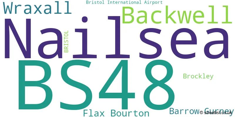
The largest settlement in the BS48 postal code is Nailsea followed by Backwell, and Wraxall.
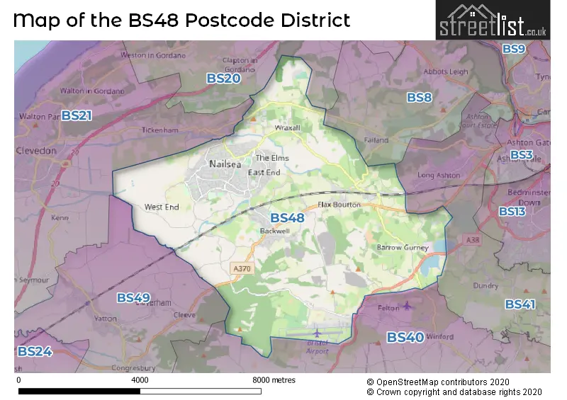
The BS48 Postcode shares a border with BS41 (Long Ashton, Dundry), BS40 (Wrington, Langford, Winford), BS49 (Yatton, Congresbury, Claverham), BS8 (BRISTOL, Clifton, Failand), BS21 (CLEVEDON, Tickenham, Kenn) and BS20 (Portishead, Pill, Easton-in-Gordano).
The primary settlement in the BS48 postcode district is Nailsea, located in the county of Somerset, England. Other significant settlements in the district include Backwell, Flax Bourton, Wraxall, Barrow Gurney, Bristol International Airport, and Brockley. The main post town for this district is Bristol.
For the district BS48, we have data on 5 postcode sectors. Here's a breakdown: The sector BS48 1, covers Nailsea and Wraxall and Flax Bourton in Somerset. The sector BS48 2, covers Nailsea in Somerset. The sector BS48 3, covers Backwell and Barrow Gurney in Somerset. The sector BS48 4, covers Nailsea in Somerset. The sector BS48 9 is non-geographic. It's often designated for PO Boxes, large organisations, or special services.

Map of the BS48 Postcode District
Explore the BS48 postcode district by using our free interactive map.
When it comes to local government, postal geography often disregards political borders. However, for a breakdown in the BS48 District: the district mostly encompasses the North Somerset area with a total of 757 postcodes.
Weather Forecast for BS48
Press Button to Show Forecast for Nailsea
| Time Period | Icon | Description | Temperature | Rain Probability | Wind |
|---|---|---|---|---|---|
| 12:00 to 15:00 | Cloudy | 12.0°C (feels like 10.0°C) | 11.00% | W 9 mph | |
| 15:00 to 18:00 | Cloudy | 12.0°C (feels like 10.0°C) | 5.00% | W 9 mph | |
| 18:00 to 21:00 | Cloudy | 11.0°C (feels like 9.0°C) | 5.00% | NNW 7 mph | |
| 21:00 to 00:00 | Cloudy | 9.0°C (feels like 7.0°C) | 4.00% | NNE 7 mph |
Press Button to Show Forecast for Nailsea
| Time Period | Icon | Description | Temperature | Rain Probability | Wind |
|---|---|---|---|---|---|
| 00:00 to 03:00 | Cloudy | 8.0°C (feels like 6.0°C) | 6.00% | NE 4 mph | |
| 03:00 to 06:00 | Overcast | 7.0°C (feels like 5.0°C) | 8.00% | ENE 7 mph | |
| 06:00 to 09:00 | Cloudy | 6.0°C (feels like 4.0°C) | 8.00% | ENE 7 mph | |
| 09:00 to 12:00 | Cloudy | 8.0°C (feels like 6.0°C) | 10.00% | E 9 mph | |
| 12:00 to 15:00 | Overcast | 10.0°C (feels like 8.0°C) | 15.00% | E 9 mph | |
| 15:00 to 18:00 | Overcast | 11.0°C (feels like 9.0°C) | 19.00% | E 9 mph | |
| 18:00 to 21:00 | Cloudy | 10.0°C (feels like 8.0°C) | 17.00% | E 7 mph | |
| 21:00 to 00:00 | Cloudy | 9.0°C (feels like 7.0°C) | 16.00% | ENE 7 mph |
Press Button to Show Forecast for Nailsea
| Time Period | Icon | Description | Temperature | Rain Probability | Wind |
|---|---|---|---|---|---|
| 00:00 to 03:00 | Cloudy | 7.0°C (feels like 5.0°C) | 14.00% | ENE 7 mph | |
| 03:00 to 06:00 | Cloudy | 7.0°C (feels like 4.0°C) | 14.00% | ENE 9 mph | |
| 06:00 to 09:00 | Overcast | 6.0°C (feels like 3.0°C) | 25.00% | NE 9 mph | |
| 09:00 to 12:00 | Light rain | 8.0°C (feels like 5.0°C) | 52.00% | ENE 11 mph | |
| 12:00 to 15:00 | Overcast | 10.0°C (feels like 7.0°C) | 21.00% | ENE 11 mph | |
| 15:00 to 18:00 | Cloudy | 11.0°C (feels like 9.0°C) | 16.00% | ENE 11 mph | |
| 18:00 to 21:00 | Overcast | 11.0°C (feels like 8.0°C) | 22.00% | NE 11 mph | |
| 21:00 to 00:00 | Light rain | 9.0°C (feels like 7.0°C) | 50.00% | NE 11 mph |
Press Button to Show Forecast for Nailsea
| Time Period | Icon | Description | Temperature | Rain Probability | Wind |
|---|---|---|---|---|---|
| 00:00 to 03:00 | Light rain | 8.0°C (feels like 6.0°C) | 51.00% | NE 11 mph | |
| 03:00 to 06:00 | Light rain | 8.0°C (feels like 5.0°C) | 52.00% | NE 11 mph | |
| 06:00 to 09:00 | Light rain | 8.0°C (feels like 5.0°C) | 52.00% | NNE 9 mph | |
| 09:00 to 12:00 | Light rain | 9.0°C (feels like 7.0°C) | 50.00% | NE 11 mph | |
| 12:00 to 15:00 | Light rain shower (day) | 11.0°C (feels like 9.0°C) | 46.00% | NNW 11 mph | |
| 15:00 to 18:00 | Light rain | 12.0°C (feels like 9.0°C) | 53.00% | NW 11 mph | |
| 18:00 to 21:00 | Light rain shower (day) | 12.0°C (feels like 10.0°C) | 35.00% | NNW 9 mph | |
| 21:00 to 00:00 | Clear night | 10.0°C (feels like 8.0°C) | 7.00% | NW 9 mph |
Where is the BS48 Postcode District?
The BS48 postcode district is located in Bristol. It is nearby towns such as Clevedon to the West, Banwell to the South West, Axbridge to the South, and Caldicot to the North. The distance from the postcode district to the center of London is approximately 112.68 miles.
The district is within the post town of BRISTOL.
The sector has postcodes within the nation of England.
The BS48 Postcode District is in the Bath and North East Somerset, North Somerset and South Gloucestershire region of Gloucestershire, Wiltshire and Bath/Bristol area within the South West (England).
| Postcode Sector | Delivery Office |
|---|---|
| BS48 1 | Nailsea Delivery Office |
| BS48 2 | Nailsea Delivery Office |
| BS48 3 | Nailsea Delivery Office |
| BS48 4 | Nailsea Delivery Office |
| B | S | 4 | 8 | - | X | X | X |
| B | S | 4 | 8 | Space | Numeric | Letter | Letter |
Tourist Attractions within the Postcode Area
We found 2 visitor attractions within the BS48 postcode area
| Noah's Ark Zoo Farm |
|---|
| Wildlife |
| Safari Park / Zoo / Aquarium / Aviary |
| View Noah's Ark Zoo Farm on Google Maps |
| Tyntesfield |
| Historic Properties |
| Historic House / House and Garden / Palace |
| View Tyntesfield on Google Maps |
Current Monthly Rental Prices
| # Bedrooms | Min Price | Max Price | Avg Price |
|---|---|---|---|
| 1 | £875 | £875 | £875 |
| 2 | £1,200 | £1,200 | £1,200 |
| 3 | £1,350 | £1,950 | £1,608 |
| 4 | £4,995 | £4,995 | £4,995 |
Current House Prices
| # Bedrooms | Min Price | Max Price | Avg Price |
|---|---|---|---|
| 3 | £985,000 | £985,000 | £985,000 |
| 4 | £795,000 | £1,375,000 | £948,845 |
| 5 | £799,995 | £1,395,000 | £1,070,569 |
| 6 | £810,000 | £2,750,000 | £1,780,000 |
| 7 | £1,500,000 | £1,500,000 | £1,500,000 |
| 10 | £1,850,000 | £1,850,000 | £1,850,000 |
Estate Agents who Operate in the BS48 District
| Logo | Name | Brand Name | Address | Contact Number | Total Properties |
|---|---|---|---|---|---|
 | Nailsea | West Coast Properties | 67 High Street, Nailsea, BS48 1AW | 01275 402820 | 42 |
 | Nailsea | Hunter Leahy | 71 High Street Nailsea BS48 1AW | 01275 402801 | 34 |
 | Nailsea | Hensons | Ivy Court, 61c High Street, Nailsea, North Somerset, BS48 1AW | 01275 402648 | 24 |
 | Nailsea | Gino's Estate Agents | 34 St. Marys Park, Nailsea, BS48 4RP | 01275 402780 | 19 |
 | Backwell | Parkers Estate Agents | Station Road, Backwell, Bristol, BS48 3NW | 01275 402771 | 15 |
| Type of Property | 2018 Average | 2018 Sales | 2017 Average | 2017 Sales | 2016 Average | 2016 Sales | 2015 Average | 2015 Sales |
|---|---|---|---|---|---|---|---|---|
| Detached | £524,827 | 169 | £496,387 | 145 | £494,827 | 191 | £412,769 | 155 |
| Semi-Detached | £316,087 | 130 | £307,009 | 138 | £293,144 | 124 | £267,098 | 133 |
| Terraced | £278,950 | 48 | £282,920 | 45 | £244,224 | 52 | £224,773 | 68 |
| Flats | £172,725 | 22 | £169,943 | 29 | £213,537 | 71 | £127,777 | 31 |