The BS6 postcode district is a postal district located in the BS Bristol postcode area with a population of 33,985 residents according to the 2021 England and Wales Census.
The area of the BS6 postcode district is 1.44 square miles which is 3.74 square kilometres or 923.32 acres.
Currently, the BS6 district has about 782 postcode units spread across 3 geographic postcode sectors.
Given that each sector allows for 400 unique postcode combinations, the district has a capacity of 1,200 postcodes. With 782 postcodes already in use, this leaves 418 units available.
The largest settlement in the BS6 postal code is BRISTOL followed by St. Andrews, and Redland.
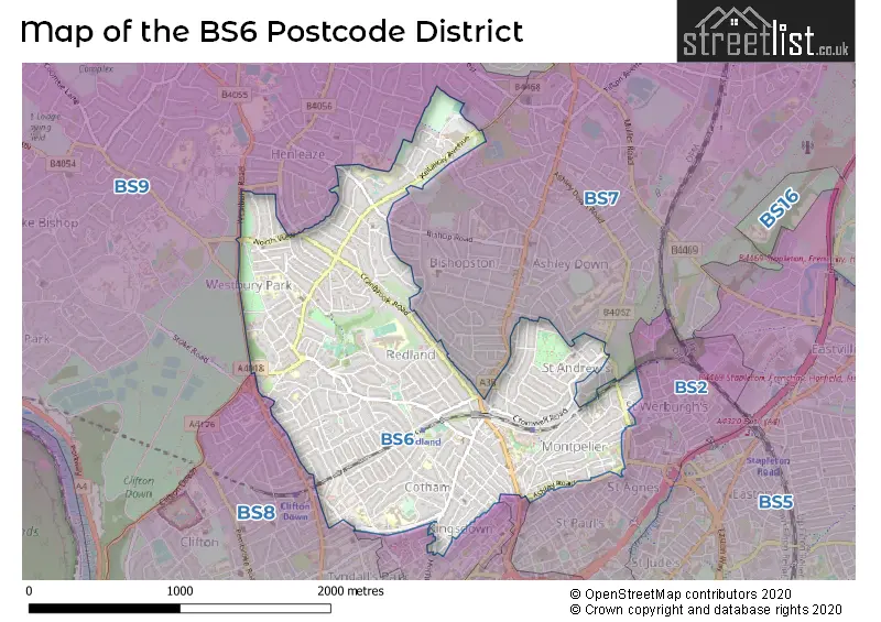
The BS6 Postcode shares a border with BS7 (BRISTOL, Horfield, Bishopston), BS8 (BRISTOL, Clifton, Failand), BS9 (BRISTOL, Westbury-on-Trym, Stoke Bishop), BS1 (BRISTOL, Redcliffe) and BS2 (BRISTOL, St. Philips, St. Pauls).
In the BS6 postcode district in Bristol, the primary settlement is Bristol itself. The most significant post town is also Bristol. The county that the district is located in is the county of Bristol in England.
For the district BS6, we have data on 4 postcode sectors. Here's a breakdown: The sector BS6 5, covers Bristol and St. Andrews and Montpelier in Bristol. The sector BS6 6, covers Bristol and Redland in Bristol. The sector BS6 7, covers Bristol and Westbury Park in Bristol. The sector BS6 9 is non-geographic. It's often designated for PO Boxes, large organisations, or special services.

Map of the BS6 Postcode District
Explore the BS6 postcode district by using our free interactive map.
When it comes to local government, postal geography often disregards political borders. However, for a breakdown in the BS6 District: the district mostly encompasses the City of Bristol (B) area with a total of 786 postcodes.
Weather Forecast for BS6
Press Button to Show Forecast for Redland
| Time Period | Icon | Description | Temperature | Rain Probability | Wind |
|---|---|---|---|---|---|
| 09:00 to 12:00 | Light rain shower (day) | 8.0°C (feels like 6.0°C) | 29.00% | W 9 mph | |
| 12:00 to 15:00 | Cloudy | 11.0°C (feels like 9.0°C) | 10.00% | W 9 mph | |
| 15:00 to 18:00 | Cloudy | 12.0°C (feels like 10.0°C) | 6.00% | W 9 mph | |
| 18:00 to 21:00 | Cloudy | 10.0°C (feels like 9.0°C) | 5.00% | NNW 7 mph | |
| 21:00 to 00:00 | Cloudy | 9.0°C (feels like 7.0°C) | 5.00% | NE 7 mph |
Press Button to Show Forecast for Redland
| Time Period | Icon | Description | Temperature | Rain Probability | Wind |
|---|---|---|---|---|---|
| 00:00 to 03:00 | Cloudy | 7.0°C (feels like 6.0°C) | 5.00% | NE 4 mph | |
| 03:00 to 06:00 | Overcast | 6.0°C (feels like 4.0°C) | 8.00% | ENE 7 mph | |
| 06:00 to 09:00 | Cloudy | 6.0°C (feels like 3.0°C) | 8.00% | ENE 7 mph | |
| 09:00 to 12:00 | Cloudy | 8.0°C (feels like 5.0°C) | 10.00% | E 9 mph | |
| 12:00 to 15:00 | Overcast | 10.0°C (feels like 8.0°C) | 15.00% | E 9 mph | |
| 15:00 to 18:00 | Overcast | 10.0°C (feels like 8.0°C) | 19.00% | E 9 mph | |
| 18:00 to 21:00 | Overcast | 10.0°C (feels like 8.0°C) | 19.00% | ENE 7 mph | |
| 21:00 to 00:00 | Cloudy | 8.0°C (feels like 6.0°C) | 16.00% | ENE 7 mph |
Press Button to Show Forecast for Redland
| Time Period | Icon | Description | Temperature | Rain Probability | Wind |
|---|---|---|---|---|---|
| 00:00 to 03:00 | Cloudy | 7.0°C (feels like 4.0°C) | 14.00% | ENE 7 mph | |
| 03:00 to 06:00 | Cloudy | 6.0°C (feels like 3.0°C) | 14.00% | ENE 9 mph | |
| 06:00 to 09:00 | Cloudy | 6.0°C (feels like 3.0°C) | 18.00% | ENE 9 mph | |
| 09:00 to 12:00 | Overcast | 7.0°C (feels like 4.0°C) | 25.00% | ENE 11 mph | |
| 12:00 to 15:00 | Overcast | 9.0°C (feels like 7.0°C) | 21.00% | ENE 11 mph | |
| 15:00 to 18:00 | Cloudy | 11.0°C (feels like 8.0°C) | 16.00% | ENE 11 mph | |
| 18:00 to 21:00 | Overcast | 10.0°C (feels like 8.0°C) | 22.00% | NE 9 mph | |
| 21:00 to 00:00 | Light rain | 9.0°C (feels like 6.0°C) | 48.00% | NE 11 mph |
Press Button to Show Forecast for Redland
| Time Period | Icon | Description | Temperature | Rain Probability | Wind |
|---|---|---|---|---|---|
| 00:00 to 03:00 | Light rain | 8.0°C (feels like 5.0°C) | 51.00% | NE 11 mph | |
| 03:00 to 06:00 | Light rain | 7.0°C (feels like 4.0°C) | 50.00% | NE 9 mph | |
| 06:00 to 09:00 | Light rain | 7.0°C (feels like 5.0°C) | 52.00% | NNE 9 mph | |
| 09:00 to 12:00 | Light rain | 9.0°C (feels like 6.0°C) | 52.00% | NNE 9 mph | |
| 12:00 to 15:00 | Light rain shower (day) | 11.0°C (feels like 8.0°C) | 45.00% | NNW 11 mph | |
| 15:00 to 18:00 | Light rain shower (day) | 11.0°C (feels like 9.0°C) | 44.00% | NW 11 mph | |
| 18:00 to 21:00 | Light rain shower (day) | 11.0°C (feels like 9.0°C) | 35.00% | NNW 9 mph | |
| 21:00 to 00:00 | Partly cloudy (night) | 9.0°C (feels like 7.0°C) | 7.00% | NW 7 mph |
Where is the BS6 Postcode District?
The postcode district for BS6 is located in Bristol. It is situated near several towns, including Clevedon to the west, Caldicot to the northwest, Bath to the southeast, Chepstow to the north, Badminton to the east, Winscombe to the southwest, and Wotton-under-Edge to the northeast. Additionally, it is approximately 106.71 miles away from the center of London.
The district is within the post town of BRISTOL.
The sector has postcodes within the nation of England.
The BS6 Postcode District is in the Bristol, City of region of Gloucestershire, Wiltshire and Bath/Bristol area within the South West (England).
| Postcode Sector | Delivery Office |
|---|---|
| BS6 5 | Bristol North Delivery Office |
| BS6 6 | Bristol North Delivery Office |
| BS6 7 | Bristol North Delivery Office |
| B | S | 6 | - | X | X | X |
| B | S | 6 | Space | Numeric | Letter | Letter |
Current Monthly Rental Prices
| # Bedrooms | Min Price | Max Price | Avg Price |
|---|---|---|---|
| £1,950 | £2,200 | £2,075 | |
| 1 | £2,100 | £2,250 | £2,190 |
| 2 | £2,100 | £3,600 | £2,793 |
| 3 | £1,800 | £2,650 | £2,135 |
| 4 | £2,400 | £3,650 | £3,025 |
| 5 | £2,900 | £3,500 | £3,200 |
| 7 | £8,000 | £8,000 | £8,000 |
| 13 | £6,370 | £6,370 | £6,370 |
Current House Prices
| # Bedrooms | Min Price | Max Price | Avg Price |
|---|---|---|---|
| 2 | £900,000 | £900,000 | £900,000 |
| 3 | £950,000 | £1,250,000 | £1,116,667 |
| 4 | £875,000 | £1,250,000 | £1,016,111 |
| 5 | £880,000 | £1,450,000 | £1,043,750 |
| 6 | £855,000 | £1,125,000 | £1,008,333 |
| 7 | £1,250,000 | £1,250,000 | £1,250,000 |
Estate Agents who Operate in the BS6 District
| Logo | Name | Brand Name | Address | Contact Number | Total Properties |
|---|---|---|---|---|---|
 | Bristol | Richard Harding | 124 Whiteladies Road, Clifton, Bristol, BS8 2RP | 0117 463 0311 | 18 |
 | Clifton | CJ Hole | 161 Whiteladies Road, Clifton, Bristol, BS8 2RF. | 01775 661205 | 12 |
 | Bristol | Boardwalk Property Co | Harbury Road, Westbury-On-Trym, Bristol, BS9 4PN | 0117 463 0220 | 11 |
 | Clifton | Ocean | 187-189 Whiteladies Road, Clifton, Bristol, BS8 2RY | 0117 463 0091 | 11 |
 | Henleaze | Maggs & Allen | 60 Northumbria Drive, Henleaze, Bristol, BS9 4HW | 0117 949 9000 | 10 |
| Type of Property | 2018 Average | 2018 Sales | 2017 Average | 2017 Sales | 2016 Average | 2016 Sales | 2015 Average | 2015 Sales |
|---|---|---|---|---|---|---|---|---|
| Detached | £715,650 | 10 | £978,071 | 14 | £664,792 | 12 | £550,220 | 15 |
| Semi-Detached | £845,739 | 76 | £795,087 | 87 | £687,599 | 86 | £618,725 | 76 |
| Terraced | £639,357 | 127 | £582,220 | 142 | £555,880 | 118 | £489,697 | 148 |
| Flats | £315,322 | 381 | £301,265 | 296 | £292,261 | 344 | £259,473 | 382 |