The CB6 postcode district is a postal district located in the CB Cambridge postcode area with a population of 39,737 residents according to the 2021 England and Wales Census.
The area of the CB6 postcode district is 100.59 square miles which is 260.53 square kilometres or 64,378.74 acres.
Currently, the CB6 district has about 852 postcode units spread across 3 geographic postcode sectors.
Given that each sector allows for 400 unique postcode combinations, the district has a capacity of 1,200 postcodes. With 852 postcodes already in use, this leaves 348 units available.
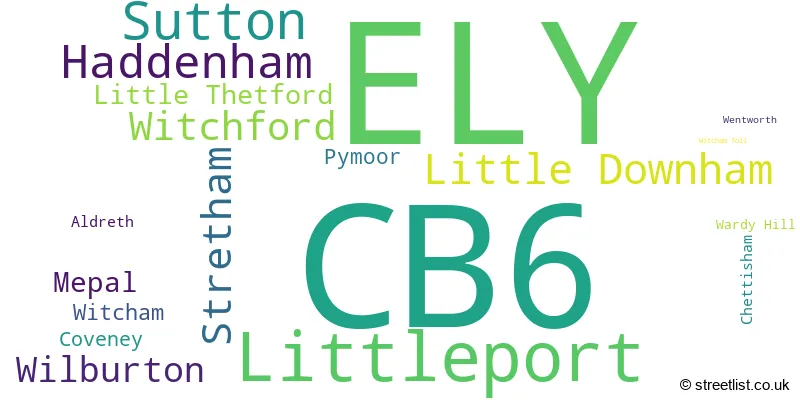
The largest settlement in the CB6 postal code is ELY followed by Littleport, and Sutton.
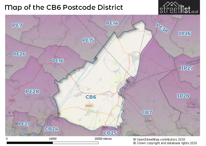
The CB6 Postcode shares a border with PE28 (Brampton, Sawtry, Warboys), PE38 (DOWNHAM MARKET, Southery, Denver), PE15 (MARCH, Manea, Doddington), PE16 (CHATTERIS), CB24 (Cottenham, Histon, Willingham), CB25 (Burwell, Waterbeach, Bottisham), CB7 (Soham, ELY, Fordham) and PE14 (Elm, Upwell, WISBECH).
In the CB6 postcode district, the primary settlement is Ely, located in the county of Cambridgeshire in England. Other significant settlements in the district include Chettisham, Littleport, Coveney, Little Downham, Mepal, Pymoor, Sutton, Wardy Hill, Witcham, Witcham Toll, Aldreth, Haddenham, Little Thetford, Stretham, Wentworth, and Wilburton.
For the district CB6, we have data on 3 postcode sectors. Here's a breakdown: The sector CB6 1, covers Littleport and Ely in Cambridgeshire. The sector CB6 2, covers Sutton and Little Downham and Witchford in Cambridgeshire. The sector CB6 3, covers Ely and Haddenham and Stretham and Wilburton in Cambridgeshire.

Map of the CB6 Postcode District
Explore the CB6 postcode district by using our free interactive map.
When it comes to local government, postal geography often disregards political borders. However, for a breakdown in the CB6 District: the district mostly encompasses the East Cambridgeshire District area with a total of 893 postcodes.
Weather Forecast for CB6
Press Button to Show Forecast for Coveney
| Time Period | Icon | Description | Temperature | Rain Probability | Wind |
|---|---|---|---|---|---|
| 03:00 to 06:00 | Cloudy | 5.0°C (feels like 2.0°C) | 4.00% | SW 7 mph | |
| 06:00 to 09:00 | Cloudy | 5.0°C (feels like 2.0°C) | 4.00% | WSW 9 mph | |
| 09:00 to 12:00 | Light rain | 8.0°C (feels like 5.0°C) | 44.00% | WNW 11 mph | |
| 12:00 to 15:00 | Light rain | 8.0°C (feels like 5.0°C) | 43.00% | NW 11 mph | |
| 15:00 to 18:00 | Cloudy | 8.0°C (feels like 6.0°C) | 44.00% | N 9 mph | |
| 18:00 to 21:00 | Partly cloudy (day) | 7.0°C (feels like 6.0°C) | 7.00% | NNE 7 mph | |
| 21:00 to 00:00 | Clear night | 4.0°C (feels like 2.0°C) | 1.00% | NE 4 mph |
Press Button to Show Forecast for Coveney
| Time Period | Icon | Description | Temperature | Rain Probability | Wind |
|---|---|---|---|---|---|
| 00:00 to 03:00 | Clear night | 2.0°C (feels like 0.0°C) | 1.00% | NNW 4 mph | |
| 03:00 to 06:00 | Clear night | 1.0°C (feels like -1.0°C) | 1.00% | NNW 4 mph | |
| 06:00 to 09:00 | Partly cloudy (day) | 3.0°C (feels like 1.0°C) | 2.00% | N 4 mph | |
| 09:00 to 12:00 | Partly cloudy (day) | 8.0°C (feels like 7.0°C) | 3.00% | NE 4 mph | |
| 12:00 to 15:00 | Overcast | 10.0°C (feels like 9.0°C) | 10.00% | NE 4 mph | |
| 15:00 to 18:00 | Overcast | 11.0°C (feels like 9.0°C) | 10.00% | ENE 7 mph | |
| 18:00 to 21:00 | Cloudy | 9.0°C (feels like 7.0°C) | 8.00% | ENE 9 mph | |
| 21:00 to 00:00 | Cloudy | 6.0°C (feels like 4.0°C) | 8.00% | E 7 mph |
Press Button to Show Forecast for Coveney
| Time Period | Icon | Description | Temperature | Rain Probability | Wind |
|---|---|---|---|---|---|
| 00:00 to 03:00 | Cloudy | 5.0°C (feels like 3.0°C) | 9.00% | ENE 7 mph | |
| 03:00 to 06:00 | Cloudy | 4.0°C (feels like 2.0°C) | 9.00% | ENE 7 mph | |
| 06:00 to 09:00 | Cloudy | 6.0°C (feels like 3.0°C) | 16.00% | ENE 7 mph | |
| 09:00 to 12:00 | Overcast | 9.0°C (feels like 7.0°C) | 20.00% | E 9 mph | |
| 12:00 to 15:00 | Overcast | 11.0°C (feels like 9.0°C) | 20.00% | E 9 mph | |
| 15:00 to 18:00 | Cloudy | 12.0°C (feels like 9.0°C) | 19.00% | E 11 mph | |
| 18:00 to 21:00 | Cloudy | 10.0°C (feels like 8.0°C) | 19.00% | ENE 9 mph | |
| 21:00 to 00:00 | Light rain | 9.0°C (feels like 6.0°C) | 49.00% | NE 9 mph |
Press Button to Show Forecast for Coveney
| Time Period | Icon | Description | Temperature | Rain Probability | Wind |
|---|---|---|---|---|---|
| 00:00 to 03:00 | Cloudy | 8.0°C (feels like 6.0°C) | 19.00% | ENE 9 mph | |
| 03:00 to 06:00 | Light rain | 8.0°C (feels like 6.0°C) | 54.00% | ENE 9 mph | |
| 06:00 to 09:00 | Light rain | 9.0°C (feels like 7.0°C) | 52.00% | E 9 mph | |
| 09:00 to 12:00 | Light rain shower (day) | 11.0°C (feels like 9.0°C) | 38.00% | SE 11 mph | |
| 12:00 to 15:00 | Heavy rain shower (day) | 12.0°C (feels like 10.0°C) | 63.00% | S 11 mph | |
| 15:00 to 18:00 | Light rain | 13.0°C (feels like 10.0°C) | 49.00% | SSW 13 mph | |
| 18:00 to 21:00 | Light rain shower (day) | 12.0°C (feels like 10.0°C) | 35.00% | S 11 mph | |
| 21:00 to 00:00 | Clear night | 9.0°C (feels like 7.0°C) | 7.00% | SSE 9 mph |
Where is the CB6 Postcode District?
The data shows that the CB6 postcode district is located in the town of Ely, which is in close proximity to several nearby towns. These nearby towns include Chatteris to the North West (6.33 miles away), St. Ives to the South West (11.52 miles away), Cambridge to the South (14.66 miles away), Downham Market to the North East (15.34 miles away), Wisbech to the North (15.40 miles away), Newmarket to the South East (16.84 miles away), and Brandon to the East (17.82 miles away). Additionally, the distance from the CB6 postcode district to the centre of London is 64.04 miles.
The district is within the post town of ELY.
The sector has postcodes within the nation of England.
The CB6 Postcode District is covers the following regions.
- Cambridgeshire CC - East Anglia - East of England
- North and West Norfolk - East Anglia - East of England
- West Essex - Essex - East of England
| Postcode Sector | Delivery Office |
|---|---|
| CB6 1 | Ely Delivery Office |
| CB6 2 | Ely Delivery Office |
| CB6 2 | Sutton (cb6) Scale Payment Delivery Office |
| CB6 3 | Ely Delivery Office |
| CB6 3 | Fordham Scale Payment Delivery Office |
| CB6 3 | Haddenham Scale Payment Delivery Office |
| CB6 3 | Wilburton Scale Payment Delivery Office |
| CB6 3 | Little Thetford Wayside Office |
| C | B | 6 | - | X | X | X |
| C | B | 6 | Space | Numeric | Letter | Letter |
Current Monthly Rental Prices
| # Bedrooms | Min Price | Max Price | Avg Price |
|---|---|---|---|
| £1 | £1,188 | £595 | |
| 1 | £775 | £775 | £775 |
| 2 | £895 | £1,200 | £990 |
| 3 | £1,100 | £1,650 | £1,325 |
| 4 | £1,650 | £2,000 | £1,825 |
| 5 | £1,900 | £2,750 | £2,163 |
| 6 | £2,500 | £2,500 | £2,500 |
Current House Prices
| # Bedrooms | Min Price | Max Price | Avg Price |
|---|---|---|---|
| £1,500,000 | £1,500,000 | £1,500,000 | |
| 4 | £675,000 | £1,675,000 | £802,723 |
| 5 | £650,000 | £900,000 | £766,000 |
| 6 | £695,000 | £850,000 | £749,167 |
| 8 | £725,000 | £725,000 | £725,000 |
| 14 | £1,500,000 | £1,500,000 | £1,500,000 |
Estate Agents who Operate in the CB6 District
| Logo | Name | Brand Name | Address | Contact Number | Total Properties |
|---|---|---|---|---|---|
 | Ely | Cheffins Residential | 25 Market Place, Ely, CB7 4NP | 01353 881291 | 90 |
 | Ely | haart | 1a Forehill, Ely, CB7 4AA | 01353 881021 | 41 |
 | Ely | Pocock & Shaw | 26 High Street, Ely, CB7 4JU | 01353 883248 | 34 |
 | Ely | William H. Brown | 6 Forehill Ely CB7 4AF | 01353 881275 | 32 |
 | Ely | Tucker Gardner | 16/18 Market Place, Ely, CB7 4NT | 01353 883260 | 22 |
| Type of Property | 2018 Average | 2018 Sales | 2017 Average | 2017 Sales | 2016 Average | 2016 Sales | 2015 Average | 2015 Sales |
|---|---|---|---|---|---|---|---|---|
| Detached | £369,073 | 260 | £361,937 | 266 | £355,248 | 283 | £307,826 | 275 |
| Semi-Detached | £254,485 | 194 | £252,863 | 197 | £239,723 | 187 | £212,084 | 204 |
| Terraced | £224,324 | 152 | £223,201 | 139 | £217,821 | 150 | £206,852 | 157 |
| Flats | £133,563 | 15 | £130,548 | 16 | £118,611 | 22 | £109,954 | 12 |