The CH3 postcode district is a postal district located in the CH Chester postcode area with a population of 36,541 residents according to the 2021 England and Wales Census.
The area of the CH3 postcode district is 69.91 square miles which is 181.07 square kilometres or 44,742.61 acres.
Currently, the CH3 district has about 1099 postcode units spread across 5 geographic postcode sectors.
Given that each sector allows for 400 unique postcode combinations, the district has a capacity of 2,000 postcodes. With 1099 postcodes already in use, this leaves 901 units available.
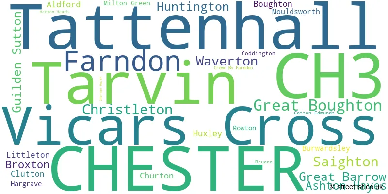
The largest settlement in the CH3 postal code is CHESTER followed by Tattenhall, and Vicars Cross.
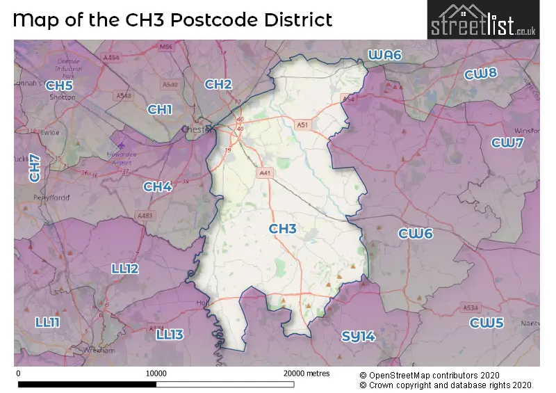
The CH3 Postcode shares a border with CW6 (TARPORLEY, Kelsall, Bunbury), WA6 (FRODSHAM, Helsby, Kingsley), SY14 (MALPAS, Tilston, Threapwood), LL12 (WREXHAM, LLAY, GRESFORD), LL13 (WREXHAM, WREXHAM INDUSTRIAL ESTATE, PENLEY), CH2 (CHESTER, Upton, Elton), CH1 (CHESTER, Blacon, Saughall) and CH4 (CHESTER, SALTNEY, BROUGHTON).
In the CH3 postcode district, Chester is the primary settlement. It is located in the county of Cheshire in England. Other significant settlements in this postcode district include Boughton, Great Boughton, and Vicars Cross. The most significant Postal town in this district is Chester.
For the district CH3, we have data on 5 postcode sectors. Here's a breakdown: The sector CH3 5, covers Chester and Vicars Cross and Great Boughton in Cheshire. The sector CH3 6, covers Farndon and Saighton and Huntington in Cheshire. The sector CH3 7, covers Waverton and Christleton and Great Barrow and Guilden Sutton in Cheshire. The sector CH3 8, covers Tarvin and Ashton Hayes in Cheshire. The sector CH3 9, covers Tattenhall and Broxton in Cheshire.

Map of the CH3 Postcode District
Explore the CH3 postcode district by using our free interactive map.
When it comes to local government, postal geography often disregards political borders. However, for a breakdown in the CH3 District: the district mostly encompasses the Cheshire West and Chester (B) area with a total of 1102 postcodes.
Weather Forecast for CH3
Press Button to Show Forecast for Bruera
| Time Period | Icon | Description | Temperature | Rain Probability | Wind |
|---|---|---|---|---|---|
| 03:00 to 06:00 | Overcast | 5.0°C (feels like 4.0°C) | 10.00% | WSW 4 mph | |
| 06:00 to 09:00 | Cloudy | 7.0°C (feels like 4.0°C) | 8.00% | W 7 mph | |
| 09:00 to 12:00 | Cloudy | 8.0°C (feels like 5.0°C) | 10.00% | NW 11 mph | |
| 12:00 to 15:00 | Cloudy | 10.0°C (feels like 8.0°C) | 6.00% | NW 11 mph | |
| 15:00 to 18:00 | Cloudy | 10.0°C (feels like 8.0°C) | 4.00% | NNW 9 mph | |
| 18:00 to 21:00 | Cloudy | 9.0°C (feels like 6.0°C) | 6.00% | NNW 9 mph | |
| 21:00 to 00:00 | Cloudy | 6.0°C (feels like 5.0°C) | 4.00% | N 4 mph |
Press Button to Show Forecast for Bruera
| Time Period | Icon | Description | Temperature | Rain Probability | Wind |
|---|---|---|---|---|---|
| 00:00 to 03:00 | Cloudy | 5.0°C (feels like 3.0°C) | 4.00% | ESE 4 mph | |
| 03:00 to 06:00 | Cloudy | 4.0°C (feels like 2.0°C) | 6.00% | E 4 mph | |
| 06:00 to 09:00 | Cloudy | 4.0°C (feels like 3.0°C) | 5.00% | E 4 mph | |
| 09:00 to 12:00 | Overcast | 8.0°C (feels like 6.0°C) | 9.00% | E 4 mph | |
| 12:00 to 15:00 | Cloudy | 9.0°C (feels like 8.0°C) | 10.00% | E 4 mph | |
| 15:00 to 18:00 | Cloudy | 10.0°C (feels like 9.0°C) | 13.00% | NE 4 mph | |
| 18:00 to 21:00 | Cloudy | 9.0°C (feels like 8.0°C) | 7.00% | NE 4 mph | |
| 21:00 to 00:00 | Cloudy | 6.0°C (feels like 4.0°C) | 7.00% | ENE 4 mph |
Press Button to Show Forecast for Bruera
| Time Period | Icon | Description | Temperature | Rain Probability | Wind |
|---|---|---|---|---|---|
| 00:00 to 03:00 | Cloudy | 5.0°C (feels like 3.0°C) | 11.00% | E 4 mph | |
| 03:00 to 06:00 | Cloudy | 4.0°C (feels like 2.0°C) | 11.00% | ENE 4 mph | |
| 06:00 to 09:00 | Cloudy | 5.0°C (feels like 3.0°C) | 10.00% | ENE 4 mph | |
| 09:00 to 12:00 | Cloudy | 8.0°C (feels like 6.0°C) | 10.00% | ENE 7 mph | |
| 12:00 to 15:00 | Overcast | 10.0°C (feels like 8.0°C) | 16.00% | ENE 9 mph | |
| 15:00 to 18:00 | Overcast | 11.0°C (feels like 9.0°C) | 20.00% | NE 9 mph | |
| 18:00 to 21:00 | Cloudy | 10.0°C (feels like 8.0°C) | 16.00% | NE 9 mph | |
| 21:00 to 00:00 | Cloudy | 8.0°C (feels like 6.0°C) | 17.00% | NE 7 mph |
Press Button to Show Forecast for Bruera
| Time Period | Icon | Description | Temperature | Rain Probability | Wind |
|---|---|---|---|---|---|
| 00:00 to 03:00 | Cloudy | 7.0°C (feels like 5.0°C) | 19.00% | NNE 7 mph | |
| 03:00 to 06:00 | Light rain | 6.0°C (feels like 4.0°C) | 50.00% | NNE 7 mph | |
| 06:00 to 09:00 | Light rain | 7.0°C (feels like 5.0°C) | 48.00% | NNE 7 mph | |
| 09:00 to 12:00 | Cloudy | 9.0°C (feels like 7.0°C) | 17.00% | NNE 9 mph | |
| 12:00 to 15:00 | Overcast | 11.0°C (feels like 9.0°C) | 29.00% | N 11 mph | |
| 15:00 to 18:00 | Light rain | 11.0°C (feels like 9.0°C) | 55.00% | N 11 mph | |
| 18:00 to 21:00 | Light rain shower (day) | 11.0°C (feels like 9.0°C) | 37.00% | NW 9 mph | |
| 21:00 to 00:00 | Clear night | 8.0°C (feels like 6.0°C) | 10.00% | WNW 7 mph |
Where is the CH3 Postcode District?
The postcode district CH3 is located in Chester. Chester is surrounded by several nearby towns which include Malpas to the South (8.69 miles away), Tarporley to the North East (9.09 miles away), Frodsham to the North (10.17 miles away), Deeside to the North West (10.53 miles away), Winsford to the East (11.31 miles away), Buckley to the West (11.71 miles away), and Nantwich to the South East (12.81 miles away). In addition, the distance between the CH3 postcode district and the center of London is approximately 159.96 miles.
The district is within the post town of CHESTER.
The sector has postcodes within the nation of England.
The CH3 Postcode District is covers the following regions.
- Cheshire West and Chester - Cheshire - North West (England)
- Cheshire East - Cheshire - North West (England)
| Postcode Sector | Delivery Office |
|---|---|
| CH3 5 | Chester Delivery Office |
| CH3 6 | Chester Delivery Office |
| CH3 7 | Chester Delivery Office |
| CH3 8 | Chester Delivery Office |
| CH3 9 | Chester Delivery Office |
| C | H | 3 | - | X | X | X |
| C | H | 3 | Space | Numeric | Letter | Letter |
Tourist Attractions within the Postcode Area
We found 1 visitor attractions within the CH3 postcode area
| Cheshire Farm Ice Cream |
|---|
| Leisure / Theme Parks |
| Leisure / Theme Park |
| View Cheshire Farm Ice Cream on Google Maps |
Current Monthly Rental Prices
| # Bedrooms | Min Price | Max Price | Avg Price |
|---|---|---|---|
| 1 | £676 | £695 | £686 |
| 2 | £770 | £1,550 | £1,229 |
| 3 | £950 | £1,800 | £1,338 |
| 4 | £1,500 | £2,200 | £1,783 |
| 5 | £1,800 | £2,300 | £2,050 |
| 6 | £2,520 | £2,520 | £2,520 |
Current House Prices
| # Bedrooms | Min Price | Max Price | Avg Price |
|---|---|---|---|
| 3 | £350,000 | £1,400,000 | £883,333 |
| 4 | £435,000 | £1,800,000 | £928,889 |
| 5 | £900,000 | £1,550,000 | £1,225,000 |
| 6 | £1,000,000 | £2,750,000 | £1,965,000 |
| 7 | £1,250,000 | £1,250,000 | £1,250,000 |
| 8 | £2,750,000 | £2,750,000 | £2,750,000 |
Estate Agents who Operate in the CH3 District
| Logo | Name | Brand Name | Address | Contact Number | Total Properties |
|---|---|---|---|---|---|
 | Chester | Thomas Property Group | Grosvenor House 13 Grosvenor Street, Chester CH1 2DD | 01244 311119 | 21 |
 | Chester | Humphreys of Chester Limited | 17/19 Lower Bridge Street, Chester, CH1 1RS | 01244 565285 | 18 |
 | Chester | Matthews of Chester | 15 Lower Bridge Street Chester Cheshire, CH1 1RS | 01244 565242 | 16 |
 | Tarporley | Hinchliffe Holmes | 56B High Street, Tarporley, CW6 0AG | 01829 730021 | 15 |
 | covering Chester & Wirral | Purplebricks | Suite 7 First Floor Cranmore Drive Shirley Solihull B90 4RZ | 020 3834 8327 | 15 |
- Aldersey Green
- Aldford
- Ashton Hayes
- Barnhill
- Broomhill
- Brown Knowl
- Broxton
- Bruera
- Burwardsley
- Chester
- Chowley
- Christleton
- Churton
- Clutton
- Coddington
- Crewe-by-Farndon
- Duddon Heath
- Dunham-on-the-Hill
- Farndon
- Fuller's Moor
- Gallantry Bank
- Gatesheath
- Great Barrow
- Greenlooms
- Guilden Sutton
- Handley
- Hargrave
- Harthill
- Hatton Heath
- Higher Burwardsley
- Hoofield
- Huxley
- Littleton
- Manley
- Milton Green
- Mouldsworth
- Newtown
- Oscroft
- Piper's Ash
- Rowton
- Saighton
- Shocklach
- Stamford Bridge
- Stretton
- Tarvin
- Tarvin Sands
- Tattenhall
- Vicarscross
- Waverton
| Type of Property | 2018 Average | 2018 Sales | 2017 Average | 2017 Sales | 2016 Average | 2016 Sales | 2015 Average | 2015 Sales |
|---|---|---|---|---|---|---|---|---|
| Detached | £414,281 | 303 | £382,890 | 326 | £394,624 | 276 | £385,463 | 293 |
| Semi-Detached | £244,853 | 246 | £248,299 | 302 | £234,096 | 229 | £233,888 | 226 |
| Terraced | £200,644 | 139 | £177,989 | 203 | £184,081 | 201 | £204,774 | 191 |
| Flats | £250,360 | 57 | £325,670 | 70 | £169,020 | 55 | £185,167 | 57 |