The CM14 postcode district is a postal district located in the CM Chelmsford postcode area with a population of 21,391 residents according to the 2021 England and Wales Census.
The area of the CM14 postcode district is 11.38 square miles which is 29.47 square kilometres or 7,282.56 acres.
Currently, the CM14 district has about 639 postcode units spread across 2 geographic postcode sectors.
Given that each sector allows for 400 unique postcode combinations, the district has a capacity of 800 postcodes. With 639 postcodes already in use, this leaves 161 units available.
The largest settlement in the CM14 postal code is BRENTWOOD followed by Warley, and Pilgrims Hatch.
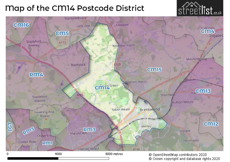
The CM14 Postcode shares a border with RM3 (ROMFORD), RM4 (LAMBOURNE, STAPLEFORD ABBOTTS, HAVERING-ATTE-BOWER), CM13 (Hutton, BRENTWOOD, WEST HORNDON) and CM15 (Pilgrims Hatch, Shenfield, BRENTWOOD).
The primary settlement in the CM14 postcode district is Brentwood, located in the county of Essex. Other significant settlements in this district include Great Warley, Kelvedon Common, Kelvedon Hatch, Navestockside, Pilgrims Hatch, South Weald, and Warley, all within the same county of Essex. Additionally, there is one settlement within the district that falls within Greater London. The most significant Postal Town within this district is Brentwood.
For the district CM14, we have data on 3 postcode sectors. Here's a breakdown: The sector CM14 4, covers Brentwood in Essex. The sector CM14 5, covers Warley and Brentwood in Essex. The sector CM14 9 is non-geographic. It's often designated for PO Boxes, large organisations, or special services.


Map of the CM14 Postcode District
Explore the CM14 postcode district by using our free interactive map.
When it comes to local government, postal geography often disregards political borders. However, for a breakdown in the CM14 District: the district mostly encompasses the Brentwood District (B) area with a total of 635 postcodes.
Weather Forecast for CM14
Press Button to Show Forecast for Brentwood
| Time Period | Icon | Description | Temperature | Rain Probability | Wind |
|---|---|---|---|---|---|
| 15:00 to 18:00 | Cloudy | 9.0°C (feels like 7.0°C) | 4.00% | NNW 13 mph | |
| 18:00 to 21:00 | Partly cloudy (day) | 8.0°C (feels like 6.0°C) | 2.00% | N 9 mph | |
| 21:00 to 00:00 | Cloudy | 5.0°C (feels like 4.0°C) | 4.00% | NNE 4 mph |
Press Button to Show Forecast for Brentwood
| Time Period | Icon | Description | Temperature | Rain Probability | Wind |
|---|---|---|---|---|---|
| 00:00 to 03:00 | Cloudy | 5.0°C (feels like 4.0°C) | 4.00% | S 4 mph | |
| 03:00 to 06:00 | Cloudy | 5.0°C (feels like 3.0°C) | 5.00% | SSW 7 mph | |
| 06:00 to 09:00 | Cloudy | 6.0°C (feels like 3.0°C) | 6.00% | WSW 9 mph | |
| 09:00 to 12:00 | Cloudy | 9.0°C (feels like 6.0°C) | 7.00% | W 11 mph | |
| 12:00 to 15:00 | Overcast | 9.0°C (feels like 7.0°C) | 13.00% | W 11 mph | |
| 15:00 to 18:00 | Cloudy | 10.0°C (feels like 7.0°C) | 14.00% | NW 11 mph | |
| 18:00 to 21:00 | Cloudy | 8.0°C (feels like 6.0°C) | 11.00% | N 7 mph | |
| 21:00 to 00:00 | Cloudy | 6.0°C (feels like 4.0°C) | 10.00% | ENE 4 mph |
Press Button to Show Forecast for Brentwood
| Time Period | Icon | Description | Temperature | Rain Probability | Wind |
|---|---|---|---|---|---|
| 00:00 to 03:00 | Cloudy | 4.0°C (feels like 2.0°C) | 4.00% | NE 7 mph | |
| 03:00 to 06:00 | Cloudy | 3.0°C (feels like 1.0°C) | 4.00% | NE 4 mph | |
| 06:00 to 09:00 | Cloudy | 4.0°C (feels like 1.0°C) | 4.00% | NE 7 mph | |
| 09:00 to 12:00 | Cloudy | 7.0°C (feels like 5.0°C) | 4.00% | ENE 7 mph | |
| 12:00 to 15:00 | Overcast | 9.0°C (feels like 7.0°C) | 9.00% | E 7 mph | |
| 15:00 to 18:00 | Overcast | 9.0°C (feels like 7.0°C) | 13.00% | E 9 mph | |
| 18:00 to 21:00 | Cloudy | 8.0°C (feels like 6.0°C) | 10.00% | E 9 mph | |
| 21:00 to 00:00 | Cloudy | 6.0°C (feels like 4.0°C) | 10.00% | E 9 mph |
Press Button to Show Forecast for Brentwood
| Time Period | Icon | Description | Temperature | Rain Probability | Wind |
|---|---|---|---|---|---|
| 00:00 to 03:00 | Cloudy | 6.0°C (feels like 3.0°C) | 13.00% | ENE 9 mph | |
| 03:00 to 06:00 | Cloudy | 5.0°C (feels like 2.0°C) | 17.00% | ENE 9 mph | |
| 06:00 to 09:00 | Cloudy | 6.0°C (feels like 3.0°C) | 20.00% | ENE 9 mph | |
| 09:00 to 12:00 | Cloudy | 9.0°C (feels like 6.0°C) | 20.00% | E 11 mph | |
| 12:00 to 15:00 | Cloudy | 11.0°C (feels like 9.0°C) | 16.00% | E 11 mph | |
| 15:00 to 18:00 | Cloudy | 12.0°C (feels like 9.0°C) | 19.00% | E 11 mph | |
| 18:00 to 21:00 | Light rain | 10.0°C (feels like 8.0°C) | 49.00% | E 11 mph | |
| 21:00 to 00:00 | Light rain | 9.0°C (feels like 7.0°C) | 51.00% | ENE 11 mph |
Press Button to Show Forecast for Brentwood
| Time Period | Icon | Description | Temperature | Rain Probability | Wind |
|---|---|---|---|---|---|
| 00:00 to 03:00 | Light rain | 9.0°C (feels like 6.0°C) | 54.00% | E 11 mph | |
| 03:00 to 06:00 | Light rain shower (night) | 9.0°C (feels like 6.0°C) | 41.00% | ESE 11 mph | |
| 06:00 to 09:00 | Light rain | 9.0°C (feels like 7.0°C) | 51.00% | SE 11 mph | |
| 09:00 to 12:00 | Heavy rain shower (day) | 10.0°C (feels like 8.0°C) | 59.00% | S 13 mph | |
| 12:00 to 15:00 | Heavy rain shower (day) | 12.0°C (feels like 10.0°C) | 61.00% | S 13 mph | |
| 15:00 to 18:00 | Heavy rain shower (day) | 13.0°C (feels like 11.0°C) | 53.00% | SSW 13 mph | |
| 18:00 to 21:00 | Light rain shower (day) | 12.0°C (feels like 10.0°C) | 35.00% | SSW 11 mph | |
| 21:00 to 00:00 | Partly cloudy (night) | 9.0°C (feels like 7.0°C) | 4.00% | SSW 11 mph |
Where is the CM14 Postcode District?
The CM14 postcode district is located in Brentwood. It is around 18.88 miles away from the centre of London. In relation to nearby towns, it is close to Pilgrims Hatch, South Weald, Noak Hill, Navestock, Warley, and Havering-Atte-Bower, which are situated in different directions from Brentwood.
The district is within the post town of BRENTWOOD.
The sector has postcodes within the nation of England.
The CM14 Postcode District is covers the following regions.
- Heart of Essex - Essex - East of England
- Barking & Dagenham and Havering - Outer London - East and North East - London
| Postcode Sector | Delivery Office |
|---|---|
| CM14 4 | Brentwood Delivery Office |
| CM14 5 | Brentwood Delivery Office |
| C | M | 1 | 4 | - | X | X | X |
| C | M | 1 | 4 | Space | Numeric | Letter | Letter |
Current Monthly Rental Prices
| # Bedrooms | Min Price | Max Price | Avg Price |
|---|---|---|---|
| 1 | £1,550 | £1,550 | £1,550 |
| 2 | £1,500 | £1,800 | £1,677 |
| 3 | £1,675 | £2,250 | £1,959 |
| 4 | £2,695 | £2,800 | £2,778 |
Current House Prices
| # Bedrooms | Min Price | Max Price | Avg Price |
|---|---|---|---|
| £4,000,000 | £4,000,000 | £4,000,000 | |
| 3 | £750,000 | £1,225,000 | £975,000 |
| 4 | £925,000 | £1,900,000 | £1,192,333 |
| 5 | £1,150,000 | £7,000,000 | £2,300,000 |
Estate Agents who Operate in the CM14 District
| Logo | Name | Brand Name | Address | Contact Number | Total Properties |
|---|---|---|---|---|---|
 | at Brentwood | Beresfords | 77 - 79 High Street Brentwood CM14 4RR | 01277 674353 | 63 |
 | Brentwood | Keith Ashton | 26 St. Thomas Road, Brentwood, CM14 4DB | 01277 674388 | 36 |
 | Brentwood | William H. Brown | Unit 1 Crown Street, Brentwood, CM14 4AZ | 01277 674650 | 25 |
 | Brentwood | HS Estate Agents | 137 Kings Road Brentwood CM14 4DR | 01277 674809 | 21 |
 | Brentwood | Balgores Hayes | 7 St. Thomas Road, Brentwood, CM14 4DB | 01277 674667 | 20 |
| Type of Property | 2018 Average | 2018 Sales | 2017 Average | 2017 Sales | 2016 Average | 2016 Sales | 2015 Average | 2015 Sales |
|---|---|---|---|---|---|---|---|---|
| Detached | £737,434 | 53 | £696,619 | 65 | £689,874 | 65 | £647,935 | 73 |
| Semi-Detached | £505,582 | 83 | £464,463 | 90 | £503,534 | 51 | £412,494 | 96 |
| Terraced | £406,929 | 95 | £414,770 | 110 | £396,247 | 102 | £328,646 | 136 |
| Flats | £272,938 | 249 | £289,543 | 232 | £274,323 | 218 | £238,670 | 274 |