The CM22 postcode district is a postal district located in the CM Chelmsford postcode area with a population of 16,134 residents according to the 2021 England and Wales Census.
The area of the CM22 postcode district is 38.31 square miles which is 99.23 square kilometres or 24,521.28 acres.
Currently, the CM22 district has about 515 postcode units spread across 2 geographic postcode sectors.
Given that each sector allows for 400 unique postcode combinations, the district has a capacity of 800 postcodes. With 515 postcodes already in use, this leaves 285 units available.
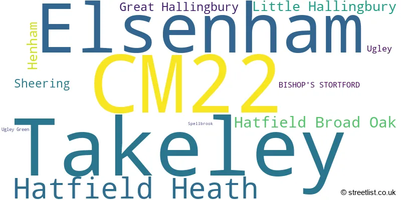
The largest settlement in the CM22 postal code is Takeley followed by Elsenham, and Hatfield Heath.
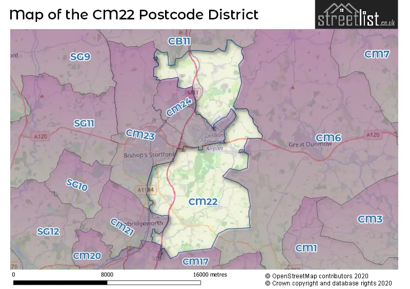
The CM22 Postcode shares a border with CB11 (SAFFRON WALDEN, Newport, Clavering), CM6 (DUNMOW, Thaxted, Felsted), CM17 (HARLOW, Newhall, Matching Green), CM21 (SAWBRIDGEWORTH, High Wych, Allens Green), CM23 (BISHOP'S STORTFORD, Birchanger, Manuden) and CM24 (STANSTED, London Stansted Airport, Burton End).
The primary settlement in the CM22 postcode district is Elsenham, located in the county of Essex, England. Other significant settlements in the district include Henham, Takeley, and Ugley. The post town for these settlements is Bishop's Stortford. There are also several smaller settlements in the district such as Ugley Green, Great Hallingbury, Hatfield Broad Oak, Hatfield Heath, Little Hallingbury, Sheering, and Spellbrook.
For the district CM22, we have data on 2 postcode sectors. Here's a breakdown: The sector CM22 6, covers Takeley and Elsenham and Henham in Essex. The sector CM22 7, covers Hatfield Heath and Hatfield Broad Oak and Little Hallingbury and Great Hallingbury and Sheering in Essex.

Map of the CM22 Postcode District
Explore the CM22 postcode district by using our free interactive map.
When it comes to local government, postal geography often disregards political borders. However, for a breakdown in the CM22 District: the district mostly encompasses the Uttlesford District (485 postcodes), followed by the Epping Forest District area (31 postcodes), and finally, the East Hertfordshire District area (6 postcodes).
Weather Forecast for CM22
Press Button to Show Forecast for London Stansted Airport
| Time Period | Icon | Description | Temperature | Rain Probability | Wind |
|---|---|---|---|---|---|
| 03:00 to 06:00 | Cloudy | 3.0°C (feels like -1.0°C) | 3.00% | NNW 9 mph | |
| 06:00 to 09:00 | Cloudy | 4.0°C (feels like 0.0°C) | 4.00% | NNW 9 mph | |
| 09:00 to 12:00 | Overcast | 7.0°C (feels like 3.0°C) | 7.00% | NNW 13 mph | |
| 12:00 to 15:00 | Overcast | 9.0°C (feels like 6.0°C) | 8.00% | NNW 13 mph | |
| 15:00 to 18:00 | Overcast | 10.0°C (feels like 7.0°C) | 9.00% | NNW 13 mph | |
| 18:00 to 21:00 | Cloudy | 9.0°C (feels like 6.0°C) | 4.00% | N 9 mph | |
| 21:00 to 00:00 | Cloudy | 5.0°C (feels like 3.0°C) | 4.00% | NE 4 mph |
Press Button to Show Forecast for London Stansted Airport
| Time Period | Icon | Description | Temperature | Rain Probability | Wind |
|---|---|---|---|---|---|
| 00:00 to 03:00 | Cloudy | 4.0°C (feels like 2.0°C) | 4.00% | SW 4 mph | |
| 03:00 to 06:00 | Cloudy | 4.0°C (feels like 1.0°C) | 4.00% | WSW 7 mph | |
| 06:00 to 09:00 | Cloudy | 5.0°C (feels like 2.0°C) | 5.00% | W 7 mph | |
| 09:00 to 12:00 | Cloudy | 8.0°C (feels like 5.0°C) | 9.00% | WNW 11 mph | |
| 12:00 to 15:00 | Cloudy | 10.0°C (feels like 8.0°C) | 14.00% | WNW 11 mph | |
| 15:00 to 18:00 | Cloudy | 11.0°C (feels like 9.0°C) | 14.00% | NW 11 mph | |
| 18:00 to 21:00 | Cloudy | 9.0°C (feels like 7.0°C) | 11.00% | NNW 9 mph | |
| 21:00 to 00:00 | Cloudy | 6.0°C (feels like 4.0°C) | 5.00% | NNE 4 mph |
Press Button to Show Forecast for London Stansted Airport
| Time Period | Icon | Description | Temperature | Rain Probability | Wind |
|---|---|---|---|---|---|
| 00:00 to 03:00 | Cloudy | 4.0°C (feels like 2.0°C) | 5.00% | NE 4 mph | |
| 03:00 to 06:00 | Cloudy | 3.0°C (feels like 1.0°C) | 5.00% | NE 4 mph | |
| 06:00 to 09:00 | Cloudy | 4.0°C (feels like 2.0°C) | 8.00% | ENE 4 mph | |
| 09:00 to 12:00 | Cloudy | 8.0°C (feels like 6.0°C) | 9.00% | ESE 7 mph | |
| 12:00 to 15:00 | Overcast | 11.0°C (feels like 9.0°C) | 15.00% | ESE 9 mph | |
| 15:00 to 18:00 | Overcast | 11.0°C (feels like 9.0°C) | 16.00% | SE 11 mph | |
| 18:00 to 21:00 | Cloudy | 10.0°C (feels like 8.0°C) | 14.00% | ESE 9 mph | |
| 21:00 to 00:00 | Cloudy | 8.0°C (feels like 5.0°C) | 13.00% | ESE 9 mph |
Press Button to Show Forecast for London Stansted Airport
| Time Period | Icon | Description | Temperature | Rain Probability | Wind |
|---|---|---|---|---|---|
| 00:00 to 03:00 | Cloudy | 7.0°C (feels like 4.0°C) | 18.00% | ESE 7 mph | |
| 03:00 to 06:00 | Cloudy | 7.0°C (feels like 4.0°C) | 19.00% | E 7 mph | |
| 06:00 to 09:00 | Cloudy | 7.0°C (feels like 5.0°C) | 19.00% | ESE 7 mph | |
| 09:00 to 12:00 | Cloudy | 11.0°C (feels like 9.0°C) | 17.00% | SE 9 mph | |
| 12:00 to 15:00 | Cloudy | 12.0°C (feels like 10.0°C) | 16.00% | SE 11 mph | |
| 15:00 to 18:00 | Light rain shower (day) | 13.0°C (feels like 11.0°C) | 39.00% | SE 11 mph | |
| 18:00 to 21:00 | Cloudy | 12.0°C (feels like 10.0°C) | 15.00% | ESE 9 mph | |
| 21:00 to 00:00 | Cloudy | 10.0°C (feels like 8.0°C) | 14.00% | NE 9 mph |
Where is the CM22 Postcode District?
The postcode district CM22 is located in the town of Bishop's Stortford. This town is situated near several nearby towns, including Stansted to the North West, Sawbridgeworth to the South West, Dunmow to the East, Matching Green to the South, and Much Hadham to the West. Additionally, Bishop's Stortford is approximately 29.1 miles away from the center of London.
The district is within the post town of BISHOP'S STORTFORD.
The sector has postcodes within the nation of England.
The CM22 Postcode District is covers the following regions.
- West Essex - Essex - East of England
- Hertfordshire - Bedfordshire and Hertfordshire - East of England
| Postcode Sector | Delivery Office |
|---|---|
| CM22 6 | Elsenham Scale Payment Delivery Office |
| CM22 6 | Takeley Scale Payment Delivery Office |
| CM22 6 | Bishops Stortford Delivery Office |
| CM22 7 | Bishops Stortford Delivery Office |
| C | M | 2 | 2 | - | X | X | X |
| C | M | 2 | 2 | Space | Numeric | Letter | Letter |
Current Monthly Rental Prices
| # Bedrooms | Min Price | Max Price | Avg Price |
|---|---|---|---|
| 2 | £1,150 | £1,500 | £1,325 |
| 3 | £1,295 | £1,900 | £1,598 |
| 4 | £3,500 | £3,500 | £3,500 |
Current House Prices
| # Bedrooms | Min Price | Max Price | Avg Price |
|---|---|---|---|
| 4 | £1,150,000 | £1,300,000 | £1,212,500 |
| 5 | £1,100,000 | £1,600,000 | £1,299,167 |
| 6 | £1,350,000 | £2,250,000 | £1,628,571 |
| 7 | £1,550,000 | £2,695,000 | £2,122,500 |
Estate Agents who Operate in the CM22 District
| Logo | Name | Brand Name | Address | Contact Number | Total Properties |
|---|---|---|---|---|---|
 | Takeley | Taylor Milburn | Priors Green, Bennet Canfield, Little Canfield, Takeley, Dunmow, CM6 1YE | 01279 594668 | 17 |
 | Little Hadham | David Lee Head Office | 13E Church End Farm Church End Little Hadham SG11 2DY | 020 3907 3367 | 15 |
 | Stansted | Intercounty | 8 Cambridge Road, Stansted, CM24 8BZ | 01279 594576 | 14 |
 | Sawbridgeworth | Wright & Co | The Old Post office, 4 Church Street, Sawbridgeworth, CM21 9AB | 01279 976949 | 13 |
 | Stansted Mountfitchet | Russell Property | Castle Maltings Lower Street, Stansted, CM24 8LP | 01279 976902 | 9 |
- Ardley End
- Bamber's Green
- Bedlar's Green
- Bishop's Stortford
- Brick End
- Broxted
- Burton End
- Elsenham
- Gaston Green
- Great Hallingbury
- Hatfield Broad Oak
- Hatfield Heath
- Hellman's Cross
- Henham
- Hope End Green
- Howe Green
- Little Canfield
- Little Hallingbury
- Molehill Green
- Newman's End
- Puttock's End
- Sawbridgeworth
- Sheering
- Smith's Green
- Spellbrook
- Stansted Mountfitchet
- Start Hill
- Takeley
- Takeley Street
- Ugley
- Ugley Green
- Woodside Green
| Type of Property | 2018 Average | 2018 Sales | 2017 Average | 2017 Sales | 2016 Average | 2016 Sales | 2015 Average | 2015 Sales |
|---|---|---|---|---|---|---|---|---|
| Detached | £590,030 | 172 | £552,361 | 180 | £571,511 | 182 | £570,793 | 148 |
| Semi-Detached | £374,999 | 62 | £365,556 | 98 | £356,927 | 80 | £339,079 | 77 |
| Terraced | £316,533 | 33 | £318,553 | 32 | £324,569 | 47 | £298,109 | 41 |
| Flats | £347,125 | 4 | £184,860 | 10 | £217,888 | 9 | £180,286 | 9 |