The CO10 postcode district is a postal district located in the CO Colchester postcode area with a population of 50,311 residents according to the 2021 England and Wales Census.
The area of the CO10 postcode district is 120.98 square miles which is 313.34 square kilometres or 77,427.17 acres.
Currently, the CO10 district has about 1618 postcode units spread across 7 geographic postcode sectors.
Given that each sector allows for 400 unique postcode combinations, the district has a capacity of 2,800 postcodes. With 1618 postcodes already in use, this leaves 1182 units available.
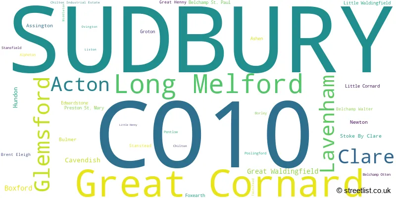
The largest settlement in the CO10 postal code is SUDBURY followed by Great Cornard, and Long Melford.
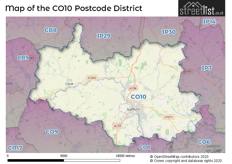
The CO10 Postcode shares a border with IP30 (Elmswell, Woolpit, Cockfield), IP7 (Hadleigh, Elmsett, Bildeston), IP29 (Barrow, Lawshall, Horringer), CB8 (NEWMARKET, Exning, Wickhambrook), CB9 (HAVERHILL, Kedington, Steeple Bumpstead), CO8 (BURES, Mount Bures, Alphamstone), CO6 (Coggeshall, Earls Colne, West Bergholt) and CO9 (HALSTEAD, Sible Hedingham, Great Yeldham).
The primary settlement in the CO10 postcode district is Sudbury, which is located in Suffolk. Other significant settlements in the district include Acton, Chilton, Great Cornard, Great Waldingfield, Little Cornard, Little Waldingfield, Long Melford, and Newton. The most significant post town in the district is Sudbury, which is also located in Suffolk.
For the district CO10, we have data on 8 postcode sectors. Here's a breakdown: The sector CO10 0, covers Great Cornard and Acton and Great Waldingfield in Suffolk. The sector CO10 1, covers Sudbury in Suffolk. The sector CO10 2, covers Sudbury in Suffolk. The sector CO10 3 is non-geographic. It's often designated for PO Boxes, large organisations, or special services. The sector CO10 5, covers Boxford and Assington and Groton and Edwardstone in Suffolk. The sector CO10 7, covers Glemsford and Sudbury in Suffolk. The sector CO10 7, covers Bulmer in Essex. The sector CO10 8, covers Clare and Cavendish and Hundon and Stoke By Clare in Suffolk. The sector CO10 9, covers Long Melford and Lavenham in Suffolk.

Map of the CO10 Postcode District
Explore the CO10 postcode district by using our free interactive map.
When it comes to local government, postal geography often disregards political borders. However, for a breakdown in the CO10 District: the district mostly encompasses the Babergh District (1286 postcodes), followed by the West Suffolk District area (194 postcodes), and finally, the Braintree District area (166 postcodes).
Weather Forecast for CO10
Press Button to Show Forecast for Melford Hall
| Time Period | Icon | Description | Temperature | Rain Probability | Wind |
|---|---|---|---|---|---|
| 18:00 to 21:00 | Cloudy | 8.0°C (feels like 5.0°C) | 4.00% | N 9 mph | |
| 21:00 to 00:00 | Partly cloudy (night) | 3.0°C (feels like 2.0°C) | 1.00% | NNW 2 mph |
Press Button to Show Forecast for Melford Hall
| Time Period | Icon | Description | Temperature | Rain Probability | Wind |
|---|---|---|---|---|---|
| 00:00 to 03:00 | Cloudy | 4.0°C (feels like 2.0°C) | 5.00% | SW 2 mph | |
| 03:00 to 06:00 | Cloudy | 4.0°C (feels like 2.0°C) | 7.00% | SSW 4 mph | |
| 06:00 to 09:00 | Cloudy | 6.0°C (feels like 3.0°C) | 6.00% | WSW 9 mph | |
| 09:00 to 12:00 | Cloudy | 8.0°C (feels like 6.0°C) | 7.00% | W 11 mph | |
| 12:00 to 15:00 | Cloudy | 8.0°C (feels like 6.0°C) | 42.00% | WNW 11 mph | |
| 15:00 to 18:00 | Cloudy | 8.0°C (feels like 5.0°C) | 42.00% | NNW 9 mph | |
| 18:00 to 21:00 | Cloudy | 7.0°C (feels like 5.0°C) | 12.00% | NNE 7 mph | |
| 21:00 to 00:00 | Partly cloudy (night) | 3.0°C (feels like 1.0°C) | 2.00% | NNE 4 mph |
Press Button to Show Forecast for Melford Hall
| Time Period | Icon | Description | Temperature | Rain Probability | Wind |
|---|---|---|---|---|---|
| 00:00 to 03:00 | Clear night | 1.0°C (feels like -1.0°C) | 1.00% | N 4 mph | |
| 03:00 to 06:00 | Clear night | 0.0°C (feels like -2.0°C) | 1.00% | N 4 mph | |
| 06:00 to 09:00 | Partly cloudy (day) | 3.0°C (feels like 1.0°C) | 1.00% | N 4 mph | |
| 09:00 to 12:00 | Partly cloudy (day) | 8.0°C (feels like 6.0°C) | 3.00% | NE 7 mph | |
| 12:00 to 15:00 | Overcast | 10.0°C (feels like 9.0°C) | 9.00% | E 4 mph | |
| 15:00 to 18:00 | Overcast | 10.0°C (feels like 8.0°C) | 12.00% | ESE 7 mph | |
| 18:00 to 21:00 | Cloudy | 8.0°C (feels like 6.0°C) | 11.00% | ESE 7 mph | |
| 21:00 to 00:00 | Cloudy | 6.0°C (feels like 4.0°C) | 9.00% | E 7 mph |
Press Button to Show Forecast for Melford Hall
| Time Period | Icon | Description | Temperature | Rain Probability | Wind |
|---|---|---|---|---|---|
| 00:00 to 03:00 | Cloudy | 5.0°C (feels like 3.0°C) | 12.00% | ENE 7 mph | |
| 03:00 to 06:00 | Cloudy | 5.0°C (feels like 3.0°C) | 13.00% | ENE 7 mph | |
| 06:00 to 09:00 | Cloudy | 6.0°C (feels like 3.0°C) | 17.00% | ENE 9 mph | |
| 09:00 to 12:00 | Overcast | 9.0°C (feels like 7.0°C) | 18.00% | E 11 mph | |
| 12:00 to 15:00 | Cloudy | 11.0°C (feels like 9.0°C) | 16.00% | E 11 mph | |
| 15:00 to 18:00 | Cloudy | 12.0°C (feels like 10.0°C) | 16.00% | E 11 mph | |
| 18:00 to 21:00 | Light rain | 11.0°C (feels like 9.0°C) | 49.00% | ENE 11 mph | |
| 21:00 to 00:00 | Cloudy | 9.0°C (feels like 7.0°C) | 20.00% | ENE 9 mph |
Press Button to Show Forecast for Melford Hall
| Time Period | Icon | Description | Temperature | Rain Probability | Wind |
|---|---|---|---|---|---|
| 00:00 to 03:00 | Light rain | 9.0°C (feels like 7.0°C) | 51.00% | E 9 mph | |
| 03:00 to 06:00 | Light rain | 9.0°C (feels like 7.0°C) | 53.00% | E 9 mph | |
| 06:00 to 09:00 | Light rain shower (day) | 10.0°C (feels like 7.0°C) | 41.00% | ESE 9 mph | |
| 09:00 to 12:00 | Light rain | 11.0°C (feels like 9.0°C) | 55.00% | SSE 13 mph | |
| 12:00 to 15:00 | Heavy rain shower (day) | 13.0°C (feels like 10.0°C) | 60.00% | S 13 mph | |
| 15:00 to 18:00 | Heavy rain shower (day) | 13.0°C (feels like 10.0°C) | 56.00% | SW 13 mph | |
| 18:00 to 21:00 | Light rain shower (day) | 12.0°C (feels like 10.0°C) | 33.00% | S 9 mph | |
| 21:00 to 00:00 | Partly cloudy (night) | 9.0°C (feels like 7.0°C) | 6.00% | S 9 mph |
Where is the CO10 Postcode District?
The CO10 postcode district is located in Sudbury, which is a district town. It is surrounded by several nearby towns, including Bures (7.2 miles to the southeast), Halstead (11.0 miles to the south), Haverhill (11.5 miles to the west), Bury St. Edmunds (12.2 miles to the north), Braintree (13.8 miles to the southwest), Stowmarket (14.8 miles to the northeast), and Newmarket (15.3 miles to the northwest). Additionally, Sudbury is approximately 52.6 miles away from the center of London.
The district is within the post town of SUDBURY.
The sector has postcodes within the nation of England.
The CO10 Postcode District is covers the following regions.
- Suffolk - East Anglia - East of England
- Essex Haven Gateway - Essex - East of England
| Postcode Sector | Delivery Office |
|---|---|
| CO10 0 | Sudbury Delivery Office |
| CO10 1 | Sudbury Delivery Office |
| CO10 2 | Sudbury Delivery Office |
| CO10 5 | Colchester Delivery Office |
| CO10 5 | Boxford Scale Payment Delivery Office |
| CO10 7 | Sudbury Delivery Office |
| CO10 8 | Sudbury Delivery Office |
| CO10 9 | Sudbury Delivery Office |
| C | O | 1 | 0 | - | X | X | X |
| C | O | 1 | 0 | Space | Numeric | Letter | Letter |
Tourist Attractions within the Postcode Area
We found 5 visitor attractions within the CO10 postcode area
| Clare Castle Country Park |
|---|
| Country Parks |
| Country Park |
| View Clare Castle Country Park on Google Maps |
| Kentwell Hall and Gardens |
| Historic Properties |
| Historic House / House and Garden / Palace |
| View Kentwell Hall and Gardens on Google Maps |
| Melford Hall |
| Historic Properties |
| Other Historic Property |
| View Melford Hall on Google Maps |
| Gainsborough's House |
| Museums & Art Galleries |
| Museum and / or Art Gallery |
| View Gainsborough's House on Google Maps |
| Lavenham Guildhall of Corpus Christi |
| Historic Properties |
| Historic House / House and Garden / Palace |
| View Lavenham Guildhall of Corpus Christi on Google Maps |
Current Monthly Rental Prices
| # Bedrooms | Min Price | Max Price | Avg Price |
|---|---|---|---|
| 2 | £925 | £1,625 | £1,097 |
| 3 | £1,025 | £2,000 | £1,370 |
| 4 | £1,500 | £2,850 | £2,300 |
| 5 | £1,400 | £2,750 | £2,075 |
Current House Prices
| # Bedrooms | Min Price | Max Price | Avg Price |
|---|---|---|---|
| £1,500,000 | £1,500,000 | £1,500,000 | |
| 3 | £142,500 | £1,550,000 | £611,667 |
| 4 | £950,000 | £1,650,000 | £1,212,500 |
| 5 | £995,000 | £1,950,000 | £1,543,889 |
| 6 | £2,000,000 | £2,000,000 | £2,000,000 |
| 7 | £1,100,000 | £1,250,000 | £1,175,000 |
| 10 | £2,100,000 | £2,100,000 | £2,100,000 |
| 11 | £3,000,000 | £3,000,000 | £3,000,000 |
| 14 | £1,750,000 | £1,750,000 | £1,750,000 |
Estate Agents who Operate in the CO10 District
| Logo | Name | Brand Name | Address | Contact Number | Total Properties |
|---|---|---|---|---|---|
 | Sudbury | William H. Brown | 22 - 24 Market Hill, Sudbury, Suffolk, CO10 2EN | 01787 321086 | 60 |
 | Sudbury | Fenn Wright | 26 Market Hill, Sudbury, CO10 2EN | 01787 322361 | 53 |
 | Long Melford | David Burr Estate Agents | Walnut Tree House Hall Street, Long Melford, CO10 9JG | 01787 322152 | 52 |
 | Sudbury | Oakheart Property | 18A Market Hill, Sudbury, CO10 2EA | 01787 323886 | 46 |
 | Sudbury | Bychoice | 6 King Street, Sudbury, CO10 2EB | 01787 322232 | 39 |
- Acton
- Alphamstone
- Alpheton
- Ashen
- Assington
- Babel Green
- Baythorne End
- Belchamp Otten
- Belchamp St Paul
- Belchamp Walter
- Borley
- Boxford
- Boyton End
- Brent Eleigh
- Bridge Street
- Brockley Green
- Bulmer
- Bulmer Tye
- Calais Street
- Cavendish
- Chilton Street
- Chilton
- Clare
- Foxearth
- Gestingthorpe
- Glemsford
- Great Henny
- Great Waldingfield
- Groton
- Hawkedon
- Horner's Green
- Hundon
- Knowl Green
- Lamarsh
- Lavenham
- Leavenheath
- Liston
- Little Cornard
- Little Waldingfield
- Long Melford
- Lower Street
- Middleton
- Milden
- Mill Green
- New England
- Newton
- Pentlow
- Poslingford
- Preston St Mary
- Rodbridge Corner
- Sherbourne Street
- Stanstead
- Stoke-by-Clare
- Stradishall
- Sudbury
- Tilbury Juxta Clare
- Upper Street
- Whelp Street
- Whitestreet Green
- Wickham St Paul
- William's Green
- Wixoe
| Type of Property | 2018 Average | 2018 Sales | 2017 Average | 2017 Sales | 2016 Average | 2016 Sales | 2015 Average | 2015 Sales |
|---|---|---|---|---|---|---|---|---|
| Detached | £428,310 | 310 | £391,366 | 374 | £401,561 | 326 | £365,252 | 345 |
| Semi-Detached | £275,036 | 247 | £269,789 | 224 | £257,672 | 225 | £233,195 | 203 |
| Terraced | £237,163 | 250 | £229,946 | 284 | £213,624 | 300 | £198,594 | 323 |
| Flats | £171,972 | 103 | £139,130 | 86 | £138,739 | 91 | £112,074 | 64 |