The CO11 postcode district is a postal district located in the CO Colchester postcode area with a population of 13,965 residents according to the 2021 England and Wales Census.
The area of the CO11 postcode district is 23.26 square miles which is 60.24 square kilometres or 14,885.89 acres.
Currently, the CO11 district has about 534 postcode units spread across 2 geographic postcode sectors.
Given that each sector allows for 400 unique postcode combinations, the district has a capacity of 800 postcodes. With 534 postcodes already in use, this leaves 266 units available.
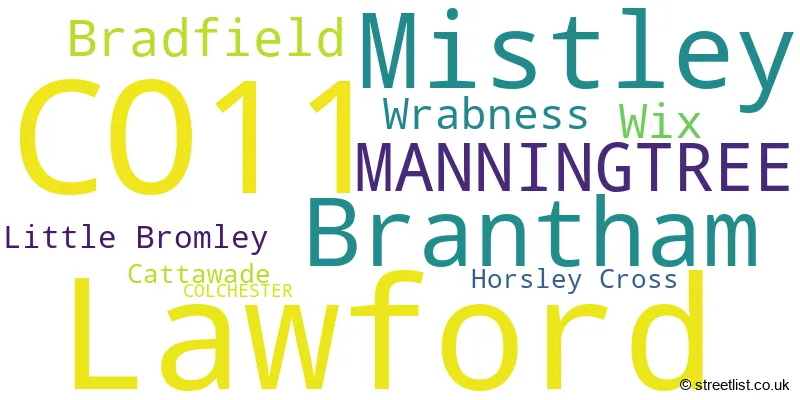
The largest settlement in the CO11 postal code is Lawford followed by Mistley, and Brantham.
The postcode area has a boundary with Harwich Harbour.
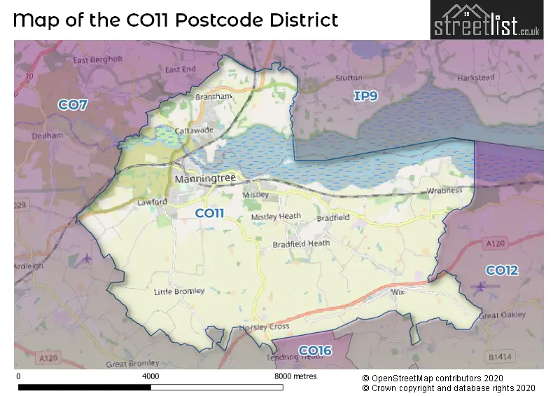
The CO11 Postcode shares a border with CO7 (Brightlingsea, Wivenhoe, Great Bentley), CO16 (CLACTON-ON-SEA, St. Osyth, Little Clacton), CO12 (HARWICH, Dovercourt, Ramsey) and IP9 (Capel St. Mary, Holbrook, Shotley Gate).
The primary settlement in the CO11 postcode district is Manningtree, which is located in the county of Essex in England. Other significant settlements in this postcode district include Brantham, Cattawade, Lawford, Mistley, Bradfield, Horsley Cross, Little Bromley, Wix, and Wrabness, all of which are also located in Essex. Additionally, there is one settlement in Suffolk called Manningtree. The most significant post town in this postcode district is Manningtree.
For the district CO11, we have data on 3 postcode sectors. Here's a breakdown: The sector CO11 1, covers Brantham in Suffolk. The sector CO11 1, covers Mistley and Manningtree in Essex. The sector CO11 2, covers Lawford and Bradfield and Wix and Mistley and Wrabness in Essex. The sector CO11 9 is non-geographic. It's often designated for PO Boxes, large organisations, or special services.

Map of the CO11 Postcode District
Explore the CO11 postcode district by using our free interactive map.
When it comes to local government, postal geography often disregards political borders. However, for a breakdown in the CO11 District: the district mostly encompasses the Tendring District (455 postcodes), and finally, the Babergh District area (107 postcodes).
Weather Forecast for CO11
Press Button to Show Forecast for Manningtree
| Time Period | Icon | Description | Temperature | Rain Probability | Wind |
|---|---|---|---|---|---|
| 06:00 to 09:00 | Cloudy | 6.0°C (feels like 3.0°C) | 6.00% | WSW 9 mph | |
| 09:00 to 12:00 | Cloudy | 9.0°C (feels like 7.0°C) | 5.00% | W 11 mph | |
| 12:00 to 15:00 | Overcast | 9.0°C (feels like 6.0°C) | 42.00% | WNW 11 mph | |
| 15:00 to 18:00 | Cloudy | 8.0°C (feels like 6.0°C) | 34.00% | NNW 11 mph | |
| 18:00 to 21:00 | Cloudy | 8.0°C (feels like 6.0°C) | 9.00% | N 7 mph | |
| 21:00 to 00:00 | Clear night | 5.0°C (feels like 3.0°C) | 3.00% | NNE 7 mph |
Press Button to Show Forecast for Manningtree
| Time Period | Icon | Description | Temperature | Rain Probability | Wind |
|---|---|---|---|---|---|
| 00:00 to 03:00 | Clear night | 3.0°C (feels like 1.0°C) | 1.00% | N 4 mph | |
| 03:00 to 06:00 | Partly cloudy (night) | 2.0°C (feels like 0.0°C) | 1.00% | NNW 4 mph | |
| 06:00 to 09:00 | Partly cloudy (day) | 4.0°C (feels like 2.0°C) | 1.00% | N 4 mph | |
| 09:00 to 12:00 | Partly cloudy (day) | 8.0°C (feels like 7.0°C) | 1.00% | ENE 7 mph | |
| 12:00 to 15:00 | Cloudy | 10.0°C (feels like 9.0°C) | 8.00% | E 7 mph | |
| 15:00 to 18:00 | Overcast | 10.0°C (feels like 8.0°C) | 11.00% | ESE 9 mph | |
| 18:00 to 21:00 | Cloudy | 9.0°C (feels like 7.0°C) | 10.00% | E 9 mph | |
| 21:00 to 00:00 | Cloudy | 6.0°C (feels like 4.0°C) | 9.00% | E 7 mph |
Press Button to Show Forecast for Manningtree
| Time Period | Icon | Description | Temperature | Rain Probability | Wind |
|---|---|---|---|---|---|
| 00:00 to 03:00 | Cloudy | 6.0°C (feels like 3.0°C) | 12.00% | ENE 9 mph | |
| 03:00 to 06:00 | Cloudy | 6.0°C (feels like 3.0°C) | 16.00% | ENE 9 mph | |
| 06:00 to 09:00 | Light rain | 7.0°C (feels like 4.0°C) | 48.00% | ENE 9 mph | |
| 09:00 to 12:00 | Overcast | 10.0°C (feels like 8.0°C) | 17.00% | E 11 mph | |
| 12:00 to 15:00 | Cloudy | 12.0°C (feels like 10.0°C) | 15.00% | E 11 mph | |
| 15:00 to 18:00 | Cloudy | 12.0°C (feels like 10.0°C) | 14.00% | E 11 mph | |
| 18:00 to 21:00 | Cloudy | 11.0°C (feels like 9.0°C) | 18.00% | ENE 11 mph | |
| 21:00 to 00:00 | Light rain | 10.0°C (feels like 8.0°C) | 50.00% | E 11 mph |
Press Button to Show Forecast for Manningtree
| Time Period | Icon | Description | Temperature | Rain Probability | Wind |
|---|---|---|---|---|---|
| 00:00 to 03:00 | Light rain | 10.0°C (feels like 8.0°C) | 52.00% | E 11 mph | |
| 03:00 to 06:00 | Heavy rain | 10.0°C (feels like 8.0°C) | 74.00% | ESE 11 mph | |
| 06:00 to 09:00 | Light rain shower (day) | 10.0°C (feels like 8.0°C) | 42.00% | SE 11 mph | |
| 09:00 to 12:00 | Light rain shower (day) | 12.0°C (feels like 9.0°C) | 39.00% | SSE 16 mph | |
| 12:00 to 15:00 | Light rain shower (day) | 13.0°C (feels like 10.0°C) | 40.00% | S 16 mph | |
| 15:00 to 18:00 | Light rain shower (day) | 14.0°C (feels like 11.0°C) | 41.00% | S 13 mph | |
| 18:00 to 21:00 | Sunny day | 13.0°C (feels like 10.0°C) | 12.00% | SSW 11 mph | |
| 21:00 to 00:00 | Partly cloudy (night) | 10.0°C (feels like 8.0°C) | 5.00% | SSW 9 mph |
Where is the CO11 Postcode District?
The postcode district CO11 is located in the town of Manningtree. Manningtree is surrounded by several nearby towns, including Harwich to the east (5.71 miles away), Colchester to the west (8.71 miles away), Ipswich to the north (8.82 miles away), Clacton-on-Sea to the south (8.98 miles away), Frinton-on-Sea to the southeast (9.09 miles away), and Woodbridge to the northeast (14.66 miles away). The distance from Manningtree to the centre of London is approximately 59.89 miles.
The district covers the post towns of COLCHESTER, MANNINGTREE.
The sector has postcodes within the nation of England.
The CO11 Postcode District is covers the following regions.
- Essex Haven Gateway - Essex - East of England
- Suffolk - East Anglia - East of England
| Postcode Sector | Delivery Office |
|---|---|
| CO11 1 | Manningtree Delivery Office |
| CO11 2 | Manningtree Delivery Office |
| C | O | 1 | 1 | - | X | X | X |
| C | O | 1 | 1 | Space | Numeric | Letter | Letter |
Tourist Attractions within the Postcode Area
We found 1 visitor attractions within the CO11 postcode area
| Manningtree and District Local History |
|---|
| Museums & Art Galleries |
| Museum and / or Art Gallery |
| View Manningtree and District Local History on Google Maps |
Current Monthly Rental Prices
| # Bedrooms | Min Price | Max Price | Avg Price |
|---|---|---|---|
| 1 | £650 | £895 | £807 |
| 2 | £850 | £1,045 | £958 |
| 3 | £1,400 | £1,400 | £1,400 |
Current House Prices
| # Bedrooms | Min Price | Max Price | Avg Price |
|---|---|---|---|
| 3 | £700,000 | £850,000 | £775,000 |
| 4 | £735,000 | £950,000 | £810,000 |
| 5 | £700,000 | £1,650,000 | £1,050,667 |
| 6 | £875,000 | £875,000 | £875,000 |
| 7 | £2,250,000 | £2,250,000 | £2,250,000 |
Estate Agents who Operate in the CO11 District
| Logo | Name | Brand Name | Address | Contact Number | Total Properties |
|---|---|---|---|---|---|
 | Manningtree | Fenn Wright | 2 Station Road, Manningtree, CO11 1AA | 01206 586079 | 31 |
 | Manningtree | Churchwood Stanley | Essex and Suffolk Office, 2 The Lane, Manningtree, CO11 1AW | 01206 586129 | 15 |
 | covering Manningtree | haart | covering Manningtree | 01206 586100 | 13 |
 | Manningtree | Chamberlain Phillips | Dairy Barn Mews, Lawford, Manningtree, CO11 2BZ | 01206 636432 | 11 |
 | Colchester St Johns | William H. Brown | 42a St. Christopher Road Colchester CO4 0NA | 01206 586062 | 9 |
| Type of Property | 2018 Average | 2018 Sales | 2017 Average | 2017 Sales | 2016 Average | 2016 Sales | 2015 Average | 2015 Sales |
|---|---|---|---|---|---|---|---|---|
| Detached | £422,150 | 127 | £398,415 | 135 | £355,769 | 121 | £326,059 | 93 |
| Semi-Detached | £260,140 | 98 | £253,175 | 91 | £241,063 | 79 | £219,544 | 60 |
| Terraced | £249,288 | 42 | £241,385 | 48 | £225,312 | 52 | £205,903 | 57 |
| Flats | £164,196 | 20 | £191,365 | 26 | £177,000 | 30 | £165,607 | 28 |