The CO13 postcode district is a postal district located in the CO Colchester postcode area with a population of 12,827 residents according to the 2021 England and Wales Census.
The area of the CO13 postcode district is 9.73 square miles which is 25.21 square kilometres or 6,228.38 acres.
Currently, the CO13 district has about 420 postcode units spread across 2 geographic postcode sectors.
Given that each sector allows for 400 unique postcode combinations, the district has a capacity of 800 postcodes. With 420 postcodes already in use, this leaves 380 units available.
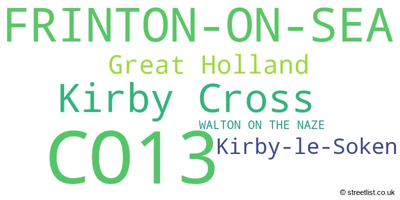
The largest settlement in the CO13 postal code is FRINTON-ON-SEA followed by Kirby Cross, and Kirby-le-Soken.
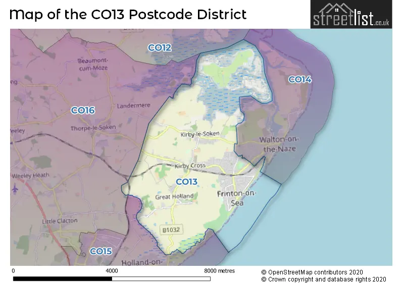
The postcode area has a boundary with Hamford Water and The North Sea.
The CO13 Postcode shares a border with CO15 (CLACTON-ON-SEA, Jaywick, Holland-on-Sea), CO14 (WALTON ON THE NAZE) and CO16 (CLACTON-ON-SEA, St. Osyth, Little Clacton).
The primary settlement in the CO13 postcode district is Frinton-on-Sea, located in the county of Essex, England. Other significant settlements include Great Holland, Kirby Cross, and Kirby-le-Soken. Frinton-on-Sea is also the most significant post town in this postcode district.
For the district CO13, we have data on 3 postcode sectors. Here's a breakdown: The sector CO13 0, covers Kirby Cross and Great Holland and Frinton-On-Sea and Kirby-Le-Soken in Essex. The sector CO13 3 is non-geographic. It's often designated for PO Boxes, large organisations, or special services. The sector CO13 9, covers Frinton-On-Sea in Essex.

Map of the CO13 Postcode District
Explore the CO13 postcode district by using our free interactive map.
When it comes to local government, postal geography often disregards political borders. However, for a breakdown in the CO13 District: the district mostly encompasses the Tendring District area with a total of 440 postcodes.
Weather Forecast for CO13
Press Button to Show Forecast for Frinton-On-Sea (Beach)
| Time Period | Icon | Description | Temperature | Rain Probability | Wind |
|---|---|---|---|---|---|
| 12:00 to 15:00 | Overcast | 9.0°C (feels like 6.0°C) | 16.00% | W 13 mph | |
| 15:00 to 18:00 | Light rain | 9.0°C (feels like 6.0°C) | 42.00% | NNW 11 mph | |
| 18:00 to 21:00 | Cloudy | 8.0°C (feels like 5.0°C) | 10.00% | N 9 mph | |
| 21:00 to 00:00 | Cloudy | 6.0°C (feels like 3.0°C) | 6.00% | N 7 mph |
Press Button to Show Forecast for Frinton-On-Sea (Beach)
| Time Period | Icon | Description | Temperature | Rain Probability | Wind |
|---|---|---|---|---|---|
| 00:00 to 03:00 | Partly cloudy (night) | 4.0°C (feels like 1.0°C) | 1.00% | N 7 mph | |
| 03:00 to 06:00 | Partly cloudy (night) | 3.0°C (feels like 0.0°C) | 2.00% | N 7 mph | |
| 06:00 to 09:00 | Partly cloudy (day) | 5.0°C (feels like 2.0°C) | 1.00% | N 7 mph | |
| 09:00 to 12:00 | Partly cloudy (day) | 8.0°C (feels like 6.0°C) | 1.00% | ENE 7 mph | |
| 12:00 to 15:00 | Cloudy | 9.0°C (feels like 7.0°C) | 5.00% | E 9 mph | |
| 15:00 to 18:00 | Overcast | 9.0°C (feels like 7.0°C) | 12.00% | ESE 9 mph | |
| 18:00 to 21:00 | Cloudy | 9.0°C (feels like 6.0°C) | 10.00% | E 11 mph | |
| 21:00 to 00:00 | Cloudy | 8.0°C (feels like 6.0°C) | 11.00% | E 11 mph |
Press Button to Show Forecast for Frinton-On-Sea (Beach)
| Time Period | Icon | Description | Temperature | Rain Probability | Wind |
|---|---|---|---|---|---|
| 00:00 to 03:00 | Cloudy | 8.0°C (feels like 6.0°C) | 14.00% | E 11 mph | |
| 03:00 to 06:00 | Light rain | 8.0°C (feels like 5.0°C) | 47.00% | E 13 mph | |
| 06:00 to 09:00 | Cloudy | 9.0°C (feels like 6.0°C) | 20.00% | E 13 mph | |
| 09:00 to 12:00 | Cloudy | 10.0°C (feels like 7.0°C) | 16.00% | E 13 mph | |
| 12:00 to 15:00 | Cloudy | 11.0°C (feels like 9.0°C) | 14.00% | ESE 13 mph | |
| 15:00 to 18:00 | Cloudy | 11.0°C (feels like 9.0°C) | 12.00% | E 13 mph | |
| 18:00 to 21:00 | Cloudy | 11.0°C (feels like 8.0°C) | 19.00% | E 13 mph | |
| 21:00 to 00:00 | Light rain | 11.0°C (feels like 8.0°C) | 51.00% | E 13 mph |
Press Button to Show Forecast for Frinton-On-Sea (Beach)
| Time Period | Icon | Description | Temperature | Rain Probability | Wind |
|---|---|---|---|---|---|
| 00:00 to 03:00 | Light rain | 11.0°C (feels like 8.0°C) | 55.00% | E 13 mph | |
| 03:00 to 06:00 | Heavy rain | 10.0°C (feels like 8.0°C) | 70.00% | ESE 13 mph | |
| 06:00 to 09:00 | Heavy rain | 11.0°C (feels like 8.0°C) | 71.00% | SE 16 mph | |
| 09:00 to 12:00 | Light rain shower (day) | 11.0°C (feels like 8.0°C) | 38.00% | SSE 18 mph | |
| 12:00 to 15:00 | Light rain shower (day) | 12.0°C (feels like 9.0°C) | 38.00% | S 18 mph | |
| 15:00 to 18:00 | Light rain shower (day) | 13.0°C (feels like 10.0°C) | 37.00% | SSW 16 mph | |
| 18:00 to 21:00 | Sunny day | 12.0°C (feels like 10.0°C) | 10.00% | S 13 mph | |
| 21:00 to 00:00 | Partly cloudy (night) | 11.0°C (feels like 8.0°C) | 5.00% | SSW 13 mph |
Where is the CO13 Postcode District?
The CO13 postcode district is located in Frinton-on-Sea. Frinton-on-Sea is a district town that is situated in close proximity to several nearby towns. The town of Walton on the Naze is located to the North East and is approximately 2.18 miles away. Clacton-on-Sea is located to the South West and is approximately 5.17 miles away. Harwich is located to the North and is approximately 5.49 miles away. Manningtree is located to the North West and is approximately 8.27 miles away. Additionally, Frinton-on-Sea is about 14.25 miles away from Colchester. In terms of distance from the center of London, Frinton-on-Sea is approximately 62.47 miles away.
The district covers the post towns of FRINTON-ON-SEA, WALTON ON THE NAZE.
The sector has postcodes within the nation of England.
The CO13 Postcode District is in the Essex Haven Gateway region of Essex within the East of England.
| Postcode Sector | Delivery Office |
|---|---|
| CO13 0 | Frinton-on-sea Delivery Office |
| CO13 9 | Frinton-on-sea Delivery Office |
| C | O | 1 | 3 | - | X | X | X |
| C | O | 1 | 3 | Space | Numeric | Letter | Letter |
Current Monthly Rental Prices
| # Bedrooms | Min Price | Max Price | Avg Price |
|---|---|---|---|
| £120 | £700 | £530 | |
| 2 | £850 | £1,000 | £934 |
| 3 | £1,200 | £1,550 | £1,348 |
| 4 | £1,900 | £1,900 | £1,900 |
Current House Prices
| # Bedrooms | Min Price | Max Price | Avg Price |
|---|---|---|---|
| £1,500,000 | £1,500,000 | £1,500,000 | |
| 4 | £875,000 | £1,100,000 | £938,364 |
| 5 | £795,000 | £1,350,000 | £1,024,166 |
| 6 | £825,000 | £950,000 | £887,500 |
| 7 | £940,000 | £940,000 | £940,000 |
| 8 | £940,000 | £975,000 | £957,500 |
Estate Agents who Operate in the CO13 District
| Logo | Name | Brand Name | Address | Contact Number | Total Properties |
|---|---|---|---|---|---|
 | Frinton on Sea | Rouse Estate Agents | 41 Connaught Avenue, Frinton-On-Sea, CO13 9PN | 01255 442176 | 97 |
 | Frinton On Sea | Paveys Estate Agents Ltd | 110 Connaught Avenue, Frinton-On-Sea, CO13 9PT | 01255 442118 | 53 |
 | Frinton-On-Sea | Sheen's | 149 Connaught Avenue, Frinton-On-Sea, CO13 9AH | 01255 442132 | 40 |
 | Frinton-on-Sea | Boydens | Gordon Suckling House, 73 Connaught Avenue Frinton-On-Sea CO13 9PP | 01259 235945 | 29 |
 | Frinton-on-Sea | Bruff Cooper | 115 Connaught Avenue, Frinton-On-Sea, CO13 9PS | 01259 235969 | 17 |
| Type of Property | 2018 Average | 2018 Sales | 2017 Average | 2017 Sales | 2016 Average | 2016 Sales | 2015 Average | 2015 Sales |
|---|---|---|---|---|---|---|---|---|
| Detached | £390,646 | 174 | £377,531 | 170 | £350,375 | 190 | £315,350 | 214 |
| Semi-Detached | £256,647 | 67 | £256,996 | 67 | £226,150 | 96 | £193,459 | 69 |
| Terraced | £202,000 | 19 | £197,889 | 18 | £200,431 | 29 | £173,112 | 20 |
| Flats | £247,801 | 69 | £246,926 | 67 | £229,042 | 82 | £193,940 | 67 |