The CO3 postcode district is a postal district located in the CO Colchester postcode area with a population of 32,840 residents according to the 2021 England and Wales Census.
The area of the CO3 postcode district is 9.37 square miles which is 24.26 square kilometres or 5,994.39 acres.
Currently, the CO3 district has about 850 postcode units spread across 5 geographic postcode sectors.
Given that each sector allows for 400 unique postcode combinations, the district has a capacity of 2,000 postcodes. With 850 postcodes already in use, this leaves 1150 units available.
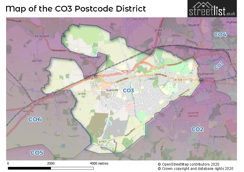
The largest settlement in the CO3 postal code is COLCHESTER followed by Stanway, and Fordham Heath.
The CO3 Postcode shares a border with CO1 (COLCHESTER), CO2 (COLCHESTER, Layer-de-la-Haye, Birch) and CO6 (Coggeshall, Earls Colne, West Bergholt).
The primary settlement in the CO3 postcode district is Stanway, which is located in the county of Essex in England. Other significant settlements in the district include Heckfordbridge, Lexden Heath, Lexden Bridge Hamlet, Fordham Heath, and Colchester. The most significant post town in the district is Colchester.
For the district CO3, we have data on 5 postcode sectors. Here's a breakdown: The sector CO3 0, covers Stanway in Essex. The sector CO3 3, covers Colchester in Essex. The sector CO3 4, covers Colchester in Essex. The sector CO3 8, covers Stanway in Essex. The sector CO3 9, covers Colchester and Fordham Heath in Essex.


Map of the CO3 Postcode District
Explore the CO3 postcode district by using our free interactive map.
When it comes to local government, postal geography often disregards political borders. However, for a breakdown in the CO3 District: the district mostly encompasses the Colchester District (B) area with a total of 862 postcodes.
Weather Forecast for CO3
Press Button to Show Forecast for Colchester
| Time Period | Icon | Description | Temperature | Rain Probability | Wind |
|---|---|---|---|---|---|
| 21:00 to 00:00 | Clear night | 6.0°C (feels like 2.0°C) | 0.00% | NNW 11 mph |
Press Button to Show Forecast for Colchester
| Time Period | Icon | Description | Temperature | Rain Probability | Wind |
|---|---|---|---|---|---|
| 00:00 to 03:00 | Clear night | 5.0°C (feels like 1.0°C) | 0.00% | NW 9 mph | |
| 03:00 to 06:00 | Cloudy | 4.0°C (feels like 1.0°C) | 5.00% | NW 9 mph | |
| 06:00 to 09:00 | Cloudy | 4.0°C (feels like 1.0°C) | 7.00% | NW 9 mph | |
| 09:00 to 12:00 | Overcast | 8.0°C (feels like 4.0°C) | 9.00% | NNW 13 mph | |
| 12:00 to 15:00 | Overcast | 10.0°C (feels like 7.0°C) | 8.00% | N 13 mph | |
| 15:00 to 18:00 | Cloudy | 10.0°C (feels like 7.0°C) | 4.00% | N 13 mph | |
| 18:00 to 21:00 | Partly cloudy (day) | 8.0°C (feels like 5.0°C) | 0.00% | N 11 mph | |
| 21:00 to 00:00 | Partly cloudy (night) | 6.0°C (feels like 3.0°C) | 1.00% | N 7 mph |
Press Button to Show Forecast for Colchester
| Time Period | Icon | Description | Temperature | Rain Probability | Wind |
|---|---|---|---|---|---|
| 00:00 to 03:00 | Cloudy | 5.0°C (feels like 2.0°C) | 4.00% | NNW 7 mph | |
| 03:00 to 06:00 | Overcast | 5.0°C (feels like 2.0°C) | 8.00% | NNW 7 mph | |
| 06:00 to 09:00 | Overcast | 5.0°C (feels like 2.0°C) | 8.00% | NNW 9 mph | |
| 09:00 to 12:00 | Overcast | 8.0°C (feels like 5.0°C) | 9.00% | N 13 mph | |
| 12:00 to 15:00 | Overcast | 10.0°C (feels like 7.0°C) | 10.00% | NNE 13 mph | |
| 15:00 to 18:00 | Cloudy | 10.0°C (feels like 8.0°C) | 6.00% | NNE 13 mph | |
| 18:00 to 21:00 | Partly cloudy (day) | 9.0°C (feels like 6.0°C) | 2.00% | NNE 11 mph | |
| 21:00 to 00:00 | Partly cloudy (night) | 6.0°C (feels like 3.0°C) | 2.00% | NNE 9 mph |
Press Button to Show Forecast for Colchester
| Time Period | Icon | Description | Temperature | Rain Probability | Wind |
|---|---|---|---|---|---|
| 00:00 to 03:00 | Clear night | 5.0°C (feels like 2.0°C) | 1.00% | N 9 mph | |
| 03:00 to 06:00 | Clear night | 4.0°C (feels like 1.0°C) | 1.00% | N 9 mph | |
| 06:00 to 09:00 | Partly cloudy (day) | 5.0°C (feels like 2.0°C) | 2.00% | N 9 mph | |
| 09:00 to 12:00 | Cloudy | 9.0°C (feels like 6.0°C) | 6.00% | NNE 9 mph | |
| 12:00 to 15:00 | Overcast | 10.0°C (feels like 8.0°C) | 12.00% | NNE 9 mph | |
| 15:00 to 18:00 | Overcast | 9.0°C (feels like 8.0°C) | 14.00% | NE 7 mph | |
| 18:00 to 21:00 | Overcast | 8.0°C (feels like 6.0°C) | 14.00% | NE 7 mph | |
| 21:00 to 00:00 | Cloudy | 6.0°C (feels like 4.0°C) | 12.00% | NE 4 mph |
Press Button to Show Forecast for Colchester
| Time Period | Icon | Description | Temperature | Rain Probability | Wind |
|---|---|---|---|---|---|
| 00:00 to 03:00 | Partly cloudy (night) | 5.0°C (feels like 3.0°C) | 7.00% | NE 7 mph | |
| 03:00 to 06:00 | Cloudy | 5.0°C (feels like 2.0°C) | 11.00% | NNW 7 mph | |
| 06:00 to 09:00 | Light rain | 5.0°C (feels like 3.0°C) | 41.00% | NNW 7 mph | |
| 09:00 to 12:00 | Light rain shower (day) | 8.0°C (feels like 7.0°C) | 29.00% | NNE 7 mph | |
| 12:00 to 15:00 | Overcast | 10.0°C (feels like 8.0°C) | 11.00% | N 9 mph | |
| 15:00 to 18:00 | Overcast | 10.0°C (feels like 8.0°C) | 12.00% | NNE 9 mph | |
| 18:00 to 21:00 | Partly cloudy (day) | 9.0°C (feels like 7.0°C) | 4.00% | NNE 9 mph | |
| 21:00 to 00:00 | Partly cloudy (night) | 7.0°C (feels like 4.0°C) | 11.00% | N 9 mph |
Where is the CO3 Postcode District?
The postcode district CO3 is located in the town of Colchester. Colchester is centrally located with nearby towns, including Bures to the North West (6.82 miles away), Halstead to the West (9.98 miles away), Witham to the South West (10.31 miles away), Manningtree to the East (11.47 miles away), Clacton-on-Sea to the South East (13.32 miles away), and Southminster to the South (15.51 miles away). Furthermore, Colchester is approximately 49.11 miles away from the center of London.
The district is within the post town of COLCHESTER.
The sector has postcodes within the nation of England.
The CO3 Postcode District is in the Essex Haven Gateway region of Essex within the East of England.
| Postcode Sector | Delivery Office |
|---|---|
| CO3 0 | Colchester Delivery Office |
| CO3 0 | Lexden Heath Scale Payment Delivery Office |
| CO3 3 | Colchester Delivery Office |
| CO3 4 | Colchester Delivery Office |
| CO3 8 | Lexden Heath Scale Payment Delivery Office |
| CO3 9 | Colchester Delivery Office |
| C | O | 3 | - | X | X | X |
| C | O | 3 | Space | Numeric | Letter | Letter |
Tourist Attractions within the Postcode Area
We found 1 visitor attractions within the CO3 postcode area
| Colchester Zoo |
|---|
| Wildlife |
| Safari Park / Zoo / Aquarium / Aviary |
| View Colchester Zoo on Google Maps |
Current Monthly Rental Prices
| # Bedrooms | Min Price | Max Price | Avg Price |
|---|---|---|---|
| £850 | £850 | £850 | |
| 1 | £650 | £2,670 | £1,230 |
| 2 | £1,100 | £1,300 | £1,200 |
| 3 | £575 | £1,750 | £1,180 |
| 4 | £1,700 | £2,250 | £2,013 |
| 6 | £2,400 | £2,400 | £2,400 |
Current House Prices
| # Bedrooms | Min Price | Max Price | Avg Price |
|---|---|---|---|
| £8,000,000 | £8,000,000 | £8,000,000 | |
| 3 | £700,000 | £700,000 | £700,000 |
| 4 | £700,000 | £975,000 | £776,818 |
| 5 | £800,000 | £1,500,000 | £1,143,750 |
| 6 | £800,000 | £1,500,000 | £1,262,500 |
Estate Agents who Operate in the CO3 District
| Logo | Name | Brand Name | Address | Contact Number | Total Properties |
|---|---|---|---|---|---|
 | Colchester | Oakheart Property | 2b Cotman Road Colchester Essex CO3 4QJ | 01206 586160 | 24 |
 | Colchester | Palmer & Partners | 43 Crouch Street Colchester CO3 3EN | 01206 586084 | 20 |
 | Colchester | Boydens | Aston House, 57-59 Crouch Street Colchester CO3 3EY | 01206 586168 | 20 |
 | Stanway | Fenn Wright | 1 Tollgate East, Stanway, Colchester, CO3 8RQ | 01206 586109 | 19 |
 | Colchester | Knight Residential | 5 Pappus House Tollgate Business Park Tollgate West Stanway Colchester CO3 8AQ | 01206 586121 | 16 |
| Type of Property | 2018 Average | 2018 Sales | 2017 Average | 2017 Sales | 2016 Average | 2016 Sales | 2015 Average | 2015 Sales |
|---|---|---|---|---|---|---|---|---|
| Detached | £416,028 | 322 | £412,602 | 319 | £390,872 | 270 | £402,703 | 268 |
| Semi-Detached | £312,522 | 255 | £299,795 | 246 | £304,734 | 203 | £270,007 | 200 |
| Terraced | £267,662 | 130 | £271,700 | 120 | £244,594 | 116 | £218,078 | 110 |
| Flats | £172,764 | 123 | £190,593 | 122 | £156,063 | 150 | £144,318 | 118 |