The CT4 postcode district is a postal district located in the CT Canterbury postcode area with a population of 17,187 residents according to the 2021 England and Wales Census.
The area of the CT4 postcode district is 80.26 square miles which is 207.88 square kilometres or 51,367.14 acres.
Currently, the CT4 district has about 810 postcode units spread across 4 geographic postcode sectors.
Given that each sector allows for 400 unique postcode combinations, the district has a capacity of 1,600 postcodes. With 810 postcodes already in use, this leaves 790 units available.
The largest settlement in the CT4 postal code is Chartham followed by Bridge, and Barham.
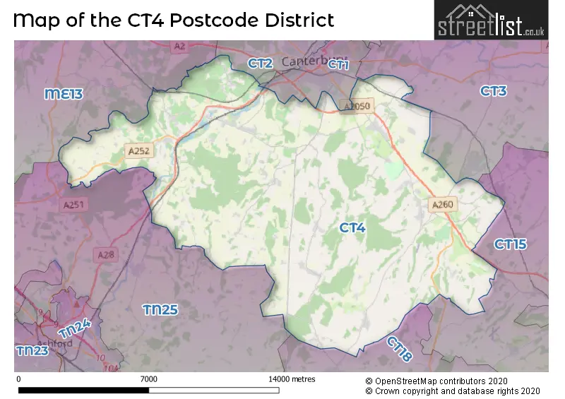
The CT4 Postcode shares a border with CT1 (CANTERBURY), CT2 (CANTERBURY, Sturry, Blean), CT3 (Aylesham, Ash, Hersden), TN25 (Wye, Sellindge, ASHFORD), CT18 (Hawkinge, Capel-le-Ferne, Lyminge), CT15 (St. Margarets-At-Cliffe, Eythorne, Shepherdswell) and ME13 (FAVERSHAM, Boughton-under-Blean, Dunkirk).
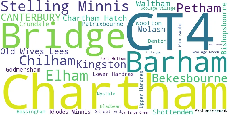
In the CT4 postcode district in Kent, the primary settlement is Bekesbourne, which has the highest count. Other significant settlements in the district include Bishopsbourne, Bridge, Garlinge Green, Lower Hardres, Patrixbourne, Petham, Pett Bottom, Stelling Minnis, Street End, Waltham, Barham, Bladbean, Bossingham, Denton, Elham, Kingston, Ottinge, Rhodes Minnis, Upper Hardres, Womenswold, Woolage Green, Woolage Village, Wootton, Canterbury, Anvil Green, Chartham, Chartham Hatch, Crundale, Godmersham, Mystole, Nackington, and Old Wives Lees. The most significant Postal Town in the district is Canterbury.
For the district CT4, we have data on 4 postcode sectors. Here's a breakdown: The sector CT4 5, covers Bridge and Petham and Bekesbourne in Kent. The sector CT4 6, covers Barham and Elham and Stelling Minnis in Kent. The sector CT4 7, covers Chartham and Canterbury and Chartham Hatch in Kent. The sector CT4 8, covers Chilham and Old Wives Lees and Molash and Shottenden in Kent.

Map of the CT4 Postcode District
Explore the CT4 postcode district by using our free interactive map.
When it comes to local government, postal geography often disregards political borders. However, for a breakdown in the CT4 District: the district mostly encompasses the Canterbury District (B) (512 postcodes), followed by the Ashford District (B) area (137 postcodes), followed by the Folkestone and Hythe District area (135 postcodes), and finally, the Dover District area (24 postcodes).
Weather Forecast for CT4
Press Button to Show Forecast for Kent C.C.C.
| Time Period | Icon | Description | Temperature | Rain Probability | Wind |
|---|---|---|---|---|---|
| 21:00 to 00:00 | Cloudy | 6.0°C (feels like 5.0°C) | 11.00% | NE 4 mph |
Press Button to Show Forecast for Kent C.C.C.
| Time Period | Icon | Description | Temperature | Rain Probability | Wind |
|---|---|---|---|---|---|
| 00:00 to 03:00 | Cloudy | 6.0°C (feels like 4.0°C) | 6.00% | NE 4 mph | |
| 03:00 to 06:00 | Cloudy | 5.0°C (feels like 3.0°C) | 6.00% | NE 4 mph | |
| 06:00 to 09:00 | Cloudy | 6.0°C (feels like 4.0°C) | 5.00% | NE 7 mph | |
| 09:00 to 12:00 | Cloudy | 8.0°C (feels like 6.0°C) | 7.00% | ENE 7 mph | |
| 12:00 to 15:00 | Cloudy | 9.0°C (feels like 7.0°C) | 10.00% | ENE 9 mph | |
| 15:00 to 18:00 | Cloudy | 9.0°C (feels like 7.0°C) | 11.00% | E 9 mph | |
| 18:00 to 21:00 | Cloudy | 8.0°C (feels like 6.0°C) | 11.00% | E 9 mph | |
| 21:00 to 00:00 | Cloudy | 7.0°C (feels like 5.0°C) | 14.00% | E 7 mph |
Press Button to Show Forecast for Kent C.C.C.
| Time Period | Icon | Description | Temperature | Rain Probability | Wind |
|---|---|---|---|---|---|
| 00:00 to 03:00 | Light rain | 7.0°C (feels like 4.0°C) | 47.00% | E 7 mph | |
| 03:00 to 06:00 | Light rain | 7.0°C (feels like 5.0°C) | 46.00% | E 7 mph | |
| 06:00 to 09:00 | Cloudy | 8.0°C (feels like 6.0°C) | 20.00% | E 7 mph | |
| 09:00 to 12:00 | Cloudy | 11.0°C (feels like 9.0°C) | 15.00% | SE 9 mph | |
| 12:00 to 15:00 | Cloudy | 12.0°C (feels like 10.0°C) | 16.00% | ESE 9 mph | |
| 15:00 to 18:00 | Cloudy | 12.0°C (feels like 10.0°C) | 20.00% | ESE 11 mph | |
| 18:00 to 21:00 | Cloudy | 11.0°C (feels like 9.0°C) | 16.00% | E 9 mph | |
| 21:00 to 00:00 | Light rain | 10.0°C (feels like 8.0°C) | 50.00% | E 9 mph |
Press Button to Show Forecast for Kent C.C.C.
| Time Period | Icon | Description | Temperature | Rain Probability | Wind |
|---|---|---|---|---|---|
| 00:00 to 03:00 | Light rain | 10.0°C (feels like 8.0°C) | 50.00% | ESE 9 mph | |
| 03:00 to 06:00 | Light rain | 10.0°C (feels like 8.0°C) | 47.00% | ESE 11 mph | |
| 06:00 to 09:00 | Cloudy | 10.0°C (feels like 8.0°C) | 20.00% | SE 11 mph | |
| 09:00 to 12:00 | Light rain shower (day) | 12.0°C (feels like 9.0°C) | 40.00% | S 16 mph | |
| 12:00 to 15:00 | Light rain shower (day) | 13.0°C (feels like 10.0°C) | 40.00% | SSW 16 mph | |
| 15:00 to 18:00 | Heavy rain shower (day) | 13.0°C (feels like 10.0°C) | 51.00% | SSW 16 mph | |
| 18:00 to 21:00 | Light rain shower (day) | 12.0°C (feels like 10.0°C) | 33.00% | S 11 mph | |
| 21:00 to 00:00 | Partly cloudy (night) | 10.0°C (feels like 8.0°C) | 9.00% | SSW 9 mph |
Where is the CT4 Postcode District?
The data indicates that the postcode district CT4 is located in Canterbury. Canterbury is the district town and is situated nearby several other towns such as Whitstable, Faversham, Hythe, Sandwich, and Deal. Additionally, the data mentions that Canterbury is approximately 55.65 miles away from the center of London.
The district is within the post town of CANTERBURY.
The sector has postcodes within the nation of England.
The CT4 Postcode District is covers the following regions.
- East Kent - Kent - South East (England)
- Mid Kent - Kent - South East (England)
| Postcode Sector | Delivery Office |
|---|---|
| CT4 5 | Canterbury Delivery Office |
| CT4 6 | Canterbury Delivery Office |
| CT4 7 | Canterbury Delivery Office |
| CT4 8 | Canterbury Delivery Office |
| CT4 6 | Barham Scale Payment Delivery Office |
| C | T | 4 | - | X | X | X |
| C | T | 4 | Space | Numeric | Letter | Letter |
Current Monthly Rental Prices
| # Bedrooms | Min Price | Max Price | Avg Price |
|---|---|---|---|
| 1 | £900 | £900 | £900 |
| 2 | £975 | £1,100 | £1,038 |
| 3 | £1,400 | £2,200 | £1,825 |
| 4 | £1,800 | £2,200 | £2,000 |
Current House Prices
| # Bedrooms | Min Price | Max Price | Avg Price |
|---|---|---|---|
| £98,400 | £1,500,000 | £710,850 | |
| 1 | £145,000 | £200,000 | £172,500 |
| 2 | £171,500 | £685,000 | £334,307 |
| 3 | £225,000 | £895,000 | £511,827 |
| 4 | £350,000 | £3,500,000 | £918,678 |
| 5 | £500,000 | £6,999,950 | £1,477,095 |
| 6 | £995,000 | £2,750,000 | £1,676,667 |
| 7 | £2,000,000 | £2,750,000 | £2,416,667 |
| 8 | £4,850,000 | £4,850,000 | £4,850,000 |
| 15 | £2,750,000 | £2,750,000 | £2,750,000 |
Estate Agents who Operate in the CT4 District
| Logo | Name | Brand Name | Address | Contact Number | Total Properties |
|---|---|---|---|---|---|
 | Lyminge, Folkestone | Laing Bennett Estate & Letting Agents | The Estate Office, 8 Station Road, Lyminge, CT18 8HP | 01303 761733 | 19 |
 | Canterbury | Miles & Barr | 14 Lower Chantry Lane Canterbury CT1 1UF | 01227 532461 | 16 |
 | Canterbury | Colebrook Sturrock | Bank Buildings, Elham, Canterbury, CT4 6TD | 01303 761690 | 14 |
 | Canterbury | Strutt & Parker | 2 St. Margarets Street, Canterbury, CT1 2SL | 01227 532506 | 14 |
 | Ashford | Hobbs Parker Estate Agents | Romney House Monument Way, Orbital Park, Ashford, TN24 0HB | 01233 542521 | 12 |
- Acrise
- Barham
- Bekesbourne
- Bekesbourne Hill
- Bishopsbourne
- Bossingham
- Bridge
- Canterbury
- Challock
- Chartham
- Chartham Hatch
- Chilham
- Crundale
- Denton
- Derringstone
- Elham
- Garlinge Green
- Godmersham
- Gravel Castle
- Hassell Street
- Hill Street
- Kingston
- Littlebourne
- Lodge Lees
- Lower Hardres
- Marley
- Molash
- Mystole
- Nackington
- Old Wives Lees
- Ottinge
- Out Elmstead
- Patrixbourne
- Petham
- Pett Bottom
- Rhodes Minnis
- Shalmsford Street
- Shelvin
- Shottenden
- Sole Street
- Stelling Minnis
- Street End
- Upper Hardres
- Waltham
- Womenswold
- Woolage Green
- Woolage Village
- Wootton
| Type of Property | 2018 Average | 2018 Sales | 2017 Average | 2017 Sales | 2016 Average | 2016 Sales | 2015 Average | 2015 Sales |
|---|---|---|---|---|---|---|---|---|
| Detached | £542,248 | 109 | £505,097 | 113 | £500,070 | 95 | £468,834 | 115 |
| Semi-Detached | £340,807 | 61 | £341,856 | 65 | £297,886 | 69 | £299,084 | 58 |
| Terraced | £304,075 | 59 | £279,607 | 56 | £273,791 | 61 | £243,759 | 69 |
| Flats | £176,905 | 11 | £175,156 | 16 | £160,625 | 24 | £163,745 | 30 |