The DA9 postcode district is a postal district located in the DA Dartford postcode area with a population of 15,244 residents according to the 2021 England and Wales Census.
The area of the DA9 postcode district is 2.19 square miles which is 5.66 square kilometres or 1,399.41 acres.
Currently, the DA9 district has about 315 postcode units spread across 1 geographic postcode sectors.
Given that each sector allows for 400 unique postcode combinations, the district has a capacity of 400 postcodes. With 315 postcodes already in use, this leaves 85 units available.
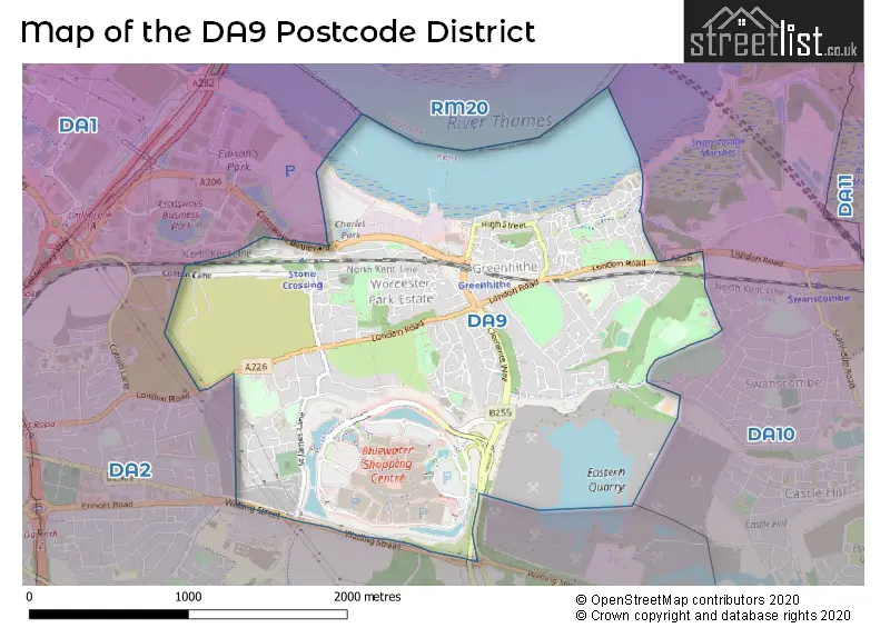
The largest settlements in the DA9 postal code are GREENHITHE and STONE.
The postcode area has a boundary with Tidal Thames.
The DA9 Postcode shares a border with DA2 (DARTFORD, WILMINGTON, DARENTH) and DA10 (SWANSCOMBE, Ebbsfleet Valley).
The primary settlement in the DA9 postcode district is Greenhithe, located in the county of Kent. Other significant settlements in the district include Bluewater. The most significant post town in this district is Greenhithe, also located in Kent.
For the district DA9, we have data on 1 postcode sectors. Here's a breakdown: The sector DA9 9, covers Greenhithe in Kent.
DA9 Postcode Sectors

Map of the DA9 Postcode District
Explore the DA9 postcode district by using our free interactive map.
When it comes to local government, postal geography often disregards political borders. However, for a breakdown in the DA9 District: the district mostly encompasses the Dartford District (B) area with a total of 325 postcodes.
Weather Forecast for DA9
Press Button to Show Forecast for Gravesend-Broadness
| Time Period | Icon | Description | Temperature | Rain Probability | Wind |
|---|---|---|---|---|---|
| 12:00 to 15:00 | Overcast | 11.0°C (feels like 9.0°C) | 13.00% | W 11 mph | |
| 15:00 to 18:00 | Cloudy | 12.0°C (feels like 10.0°C) | 17.00% | WNW 9 mph | |
| 18:00 to 21:00 | Cloudy | 9.0°C (feels like 8.0°C) | 43.00% | N 7 mph | |
| 21:00 to 00:00 | Cloudy | 8.0°C (feels like 6.0°C) | 9.00% | ENE 7 mph |
Press Button to Show Forecast for Gravesend-Broadness
| Time Period | Icon | Description | Temperature | Rain Probability | Wind |
|---|---|---|---|---|---|
| 00:00 to 03:00 | Cloudy | 6.0°C (feels like 5.0°C) | 6.00% | NE 4 mph | |
| 03:00 to 06:00 | Cloudy | 5.0°C (feels like 3.0°C) | 5.00% | NE 4 mph | |
| 06:00 to 09:00 | Cloudy | 6.0°C (feels like 4.0°C) | 5.00% | NE 7 mph | |
| 09:00 to 12:00 | Cloudy | 8.0°C (feels like 6.0°C) | 5.00% | ENE 7 mph | |
| 12:00 to 15:00 | Cloudy | 9.0°C (feels like 8.0°C) | 7.00% | E 7 mph | |
| 15:00 to 18:00 | Cloudy | 10.0°C (feels like 8.0°C) | 11.00% | E 9 mph | |
| 18:00 to 21:00 | Cloudy | 9.0°C (feels like 7.0°C) | 11.00% | E 9 mph | |
| 21:00 to 00:00 | Cloudy | 8.0°C (feels like 5.0°C) | 13.00% | E 9 mph |
Press Button to Show Forecast for Gravesend-Broadness
| Time Period | Icon | Description | Temperature | Rain Probability | Wind |
|---|---|---|---|---|---|
| 00:00 to 03:00 | Light rain | 7.0°C (feels like 5.0°C) | 45.00% | E 9 mph | |
| 03:00 to 06:00 | Light rain | 7.0°C (feels like 5.0°C) | 48.00% | ENE 9 mph | |
| 06:00 to 09:00 | Overcast | 8.0°C (feels like 6.0°C) | 21.00% | ENE 9 mph | |
| 09:00 to 12:00 | Cloudy | 10.0°C (feels like 8.0°C) | 21.00% | E 9 mph | |
| 12:00 to 15:00 | Cloudy | 12.0°C (feels like 10.0°C) | 17.00% | E 9 mph | |
| 15:00 to 18:00 | Light rain shower (day) | 13.0°C (feels like 10.0°C) | 40.00% | E 11 mph | |
| 18:00 to 21:00 | Light rain | 12.0°C (feels like 9.0°C) | 52.00% | E 11 mph | |
| 21:00 to 00:00 | Light rain | 10.0°C (feels like 8.0°C) | 51.00% | E 9 mph |
Press Button to Show Forecast for Gravesend-Broadness
| Time Period | Icon | Description | Temperature | Rain Probability | Wind |
|---|---|---|---|---|---|
| 00:00 to 03:00 | Light rain | 10.0°C (feels like 8.0°C) | 54.00% | E 9 mph | |
| 03:00 to 06:00 | Light rain | 10.0°C (feels like 8.0°C) | 52.00% | ESE 9 mph | |
| 06:00 to 09:00 | Heavy rain | 10.0°C (feels like 8.0°C) | 71.00% | SE 9 mph | |
| 09:00 to 12:00 | Light rain shower (day) | 12.0°C (feels like 10.0°C) | 44.00% | S 11 mph | |
| 12:00 to 15:00 | Light rain shower (day) | 14.0°C (feels like 11.0°C) | 41.00% | S 11 mph | |
| 15:00 to 18:00 | Heavy rain shower (day) | 15.0°C (feels like 12.0°C) | 52.00% | SSW 11 mph | |
| 18:00 to 21:00 | Light rain shower (day) | 14.0°C (feels like 12.0°C) | 36.00% | SSW 9 mph | |
| 21:00 to 00:00 | Partly cloudy (night) | 10.0°C (feels like 9.0°C) | 6.00% | SSW 7 mph |
Where is the DA9 Postcode District?
The data's postcode district is located in Greenhithe. Greenhithe is a town that is situated nearby several other towns. Bluewater is located to the southwest, Horns Cross is located to the west, High Street is located to the northeast, Crossways Business Park is located to the northwest, Bean is located to the southeast, and Darenth is located to the south. Additionally, Greenhithe is approximately 17.94 miles away from the center of London.
The district is within the post town of GREENHITHE.
The sector has postcodes within the nation of England.
The DA9 Postcode District is in the Kent Thames Gateway region of Kent within the South East (England).
Postcode Sectors within the DA9 District
| Postcode Sector | Delivery Office |
|---|---|
| DA9 9 | Swanscombe Delivery Office |
| D | A | 9 | - | X | X | X |
| D | A | 9 | Space | Numeric | Letter | Letter |
Current Monthly Rental Prices
| # Bedrooms | Min Price | Max Price | Avg Price |
|---|---|---|---|
| 1 | £650 | £1,250 | £1,069 |
| 2 | £1,250 | £1,800 | £1,641 |
| 3 | £1,600 | £1,695 | £1,648 |
| 4 | £2,350 | £2,900 | £2,625 |
Current House Prices
| # Bedrooms | Min Price | Max Price | Avg Price |
|---|---|---|---|
| £6,700 | £699,950 | £402,217 | |
| 1 | £106,000 | £245,000 | £185,261 |
| 2 | £81,250 | £400,000 | £281,363 |
| 3 | £200,000 | £500,000 | £415,172 |
| 4 | £297,500 | £925,000 | £561,654 |
| 5 | £550,000 | £750,000 | £641,667 |
Estate Agents who Operate in the DA9 District
| Logo | Name | Brand Name | Address | Contact Number | Total Properties |
|---|---|---|---|---|---|
 | Swanscombe | Robinson Jackson | 39 High Street Swanscombe DA10 0AG | 01322 946919 | 17 |
 | Dartford | Mann | 14 Market Street, Dartford, Kent, DA1 1ET | 01322 952263 | 8 |
 | South East | Yopa | Meridian House Wheatfield Way Hinckley LE10 1YG | 01322 952994 | 7 |
 | Swanscombe | Anthony Martin | 45 High Street, Swanscombe, DA10 0AG | 01328 801652 | 6 |
 | Dartford | Wards | 7 Market Street, Dartford, Kent, DA1 1EB | 01322 936108 | 6 |
| Type of Property | 2018 Average | 2018 Sales | 2017 Average | 2017 Sales | 2016 Average | 2016 Sales | 2015 Average | 2015 Sales |
|---|---|---|---|---|---|---|---|---|
| Detached | £470,105 | 38 | £462,458 | 25 | £487,039 | 37 | £343,488 | 20 |
| Semi-Detached | £380,204 | 70 | £381,311 | 74 | £344,813 | 80 | £296,968 | 33 |
| Terraced | £319,083 | 105 | £335,682 | 139 | £309,886 | 123 | £271,995 | 120 |
| Flats | £209,528 | 204 | £209,023 | 193 | £215,189 | 208 | £200,539 | 261 |