The DH9 postcode district is a postal district located in the DH Durham postcode area with a population of 37,251 residents according to the 2021 England and Wales Census.
The area of the DH9 postcode district is 19.14 square miles which is 49.57 square kilometres or 12,249.31 acres.
Currently, the DH9 district has about 1196 postcode units spread across 5 geographic postcode sectors.
Given that each sector allows for 400 unique postcode combinations, the district has a capacity of 2,000 postcodes. With 1196 postcodes already in use, this leaves 804 units available.
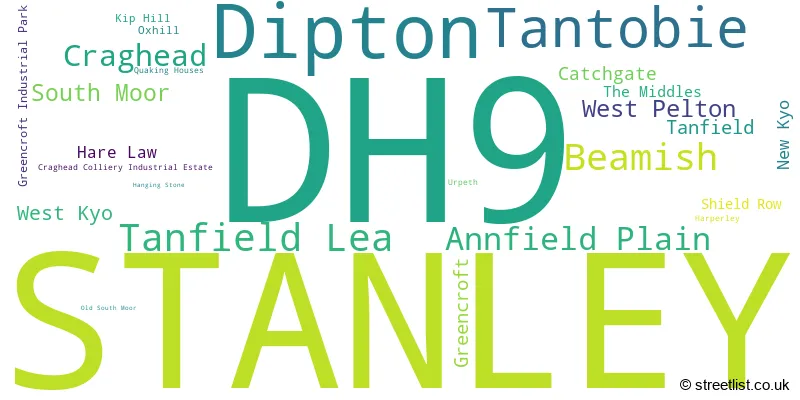
The largest settlement in the DH9 postal code is STANLEY followed by Dipton, and Tanfield Lea.
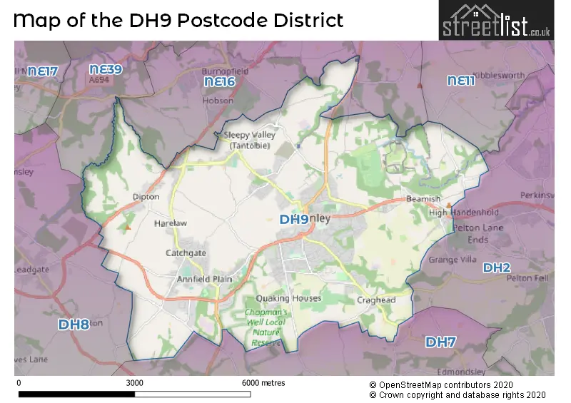
The DH9 Postcode shares a border with DH8 (CONSETT, Blackhill, Leadgate), DH7 (Sacriston, Brandon, Ushaw Moor), NE16 (Whickham, Burnopfield, Sunniside) and NE39 (ROWLANDS GILL, High Spen, Hamsterley Mill).
The primary settlement in the DH9 postcode district is Stanley, which is located in the county of Durham in England. Other significant settlements in the district include Beamish, Kip Hill, Shield Row, Urpeth, Craghead, South Moor, The Middles, West Pelton, Annfield Plain, Greencroft, New Kyo, Old South Moor, Oxhill, Quaking Houses, Catchgate, Hanging Stone, Hare Law, and West Kyo. The most significant post town in the DH9 postcode district is also Stanley.
For the district DH9, we have data on 5 postcode sectors. Here's a breakdown: The sector DH9 0, covers Stanley and Beamish in Durham. The sector DH9 6, covers Stanley and Craghead in Durham. The sector DH9 7, covers Stanley in Durham. The sector DH9 8, covers Stanley in Durham. The sector DH9 9, covers Dipton and Tantobie and Tanfield Lea in Durham.

Map of the DH9 Postcode District
Explore the DH9 postcode district by using our free interactive map.
When it comes to local government, postal geography often disregards political borders. However, for a breakdown in the DH9 District: the district mostly encompasses the County Durham (1201 postcodes), and finally, the Gateshead District (B) area (3 postcodes).
Weather Forecast for DH9
Press Button to Show Forecast for Stanley
| Time Period | Icon | Description | Temperature | Rain Probability | Wind |
|---|---|---|---|---|---|
| 18:00 to 21:00 | Cloudy | 7.0°C (feels like 3.0°C) | 3.00% | N 11 mph | |
| 21:00 to 00:00 | Cloudy | 4.0°C (feels like 2.0°C) | 3.00% | NW 7 mph |
Press Button to Show Forecast for Stanley
| Time Period | Icon | Description | Temperature | Rain Probability | Wind |
|---|---|---|---|---|---|
| 00:00 to 03:00 | Cloudy | 4.0°C (feels like 0.0°C) | 5.00% | NNW 9 mph | |
| 03:00 to 06:00 | Overcast | 3.0°C (feels like -1.0°C) | 7.00% | NW 11 mph | |
| 06:00 to 09:00 | Cloudy | 2.0°C (feels like -2.0°C) | 5.00% | NNW 11 mph | |
| 09:00 to 12:00 | Overcast | 5.0°C (feels like 1.0°C) | 9.00% | N 11 mph | |
| 12:00 to 15:00 | Cloudy | 7.0°C (feels like 4.0°C) | 7.00% | N 11 mph | |
| 15:00 to 18:00 | Cloudy | 7.0°C (feels like 5.0°C) | 5.00% | N 9 mph | |
| 18:00 to 21:00 | Cloudy | 6.0°C (feels like 4.0°C) | 4.00% | E 7 mph | |
| 21:00 to 00:00 | Cloudy | 4.0°C (feels like 1.0°C) | 5.00% | SW 7 mph |
Press Button to Show Forecast for Stanley
| Time Period | Icon | Description | Temperature | Rain Probability | Wind |
|---|---|---|---|---|---|
| 00:00 to 03:00 | Cloudy | 4.0°C (feels like 1.0°C) | 6.00% | W 11 mph | |
| 03:00 to 06:00 | Cloudy | 4.0°C (feels like 0.0°C) | 20.00% | NW 9 mph | |
| 06:00 to 09:00 | Cloudy | 3.0°C (feels like 0.0°C) | 21.00% | NW 9 mph | |
| 09:00 to 12:00 | Overcast | 5.0°C (feels like 2.0°C) | 11.00% | NNW 11 mph | |
| 12:00 to 15:00 | Light rain | 7.0°C (feels like 4.0°C) | 41.00% | N 9 mph | |
| 15:00 to 18:00 | Overcast | 7.0°C (feels like 4.0°C) | 12.00% | NNE 9 mph | |
| 18:00 to 21:00 | Cloudy | 5.0°C (feels like 3.0°C) | 7.00% | NE 9 mph | |
| 21:00 to 00:00 | Clear night | 2.0°C (feels like 0.0°C) | 2.00% | NE 4 mph |
Press Button to Show Forecast for Stanley
| Time Period | Icon | Description | Temperature | Rain Probability | Wind |
|---|---|---|---|---|---|
| 00:00 to 03:00 | Cloudy | 1.0°C (feels like -1.0°C) | 4.00% | WNW 4 mph | |
| 03:00 to 06:00 | Cloudy | 0.0°C (feels like -2.0°C) | 6.00% | WNW 4 mph | |
| 06:00 to 09:00 | Cloudy | 2.0°C (feels like 0.0°C) | 7.00% | WNW 4 mph | |
| 09:00 to 12:00 | Overcast | 5.0°C (feels like 3.0°C) | 13.00% | ENE 7 mph | |
| 12:00 to 15:00 | Overcast | 7.0°C (feels like 4.0°C) | 13.00% | E 7 mph | |
| 15:00 to 18:00 | Overcast | 7.0°C (feels like 4.0°C) | 14.00% | E 9 mph | |
| 18:00 to 21:00 | Cloudy | 6.0°C (feels like 3.0°C) | 11.00% | E 7 mph | |
| 21:00 to 00:00 | Partly cloudy (night) | 3.0°C (feels like 1.0°C) | 5.00% | ESE 7 mph |
Press Button to Show Forecast for Stanley
| Time Period | Icon | Description | Temperature | Rain Probability | Wind |
|---|---|---|---|---|---|
| 00:00 to 03:00 | Cloudy | 3.0°C (feels like 0.0°C) | 9.00% | E 4 mph | |
| 03:00 to 06:00 | Cloudy | 2.0°C (feels like -1.0°C) | 10.00% | E 4 mph | |
| 06:00 to 09:00 | Cloudy | 3.0°C (feels like 1.0°C) | 13.00% | E 7 mph | |
| 09:00 to 12:00 | Light rain | 6.0°C (feels like 3.0°C) | 48.00% | E 9 mph | |
| 12:00 to 15:00 | Overcast | 7.0°C (feels like 4.0°C) | 24.00% | E 11 mph | |
| 15:00 to 18:00 | Light rain | 8.0°C (feels like 5.0°C) | 48.00% | ENE 11 mph | |
| 18:00 to 21:00 | Light rain shower (day) | 7.0°C (feels like 4.0°C) | 32.00% | ENE 9 mph | |
| 21:00 to 00:00 | Partly cloudy (night) | 5.0°C (feels like 2.0°C) | 12.00% | ENE 7 mph |
Where is the DH9 Postcode District?
The data shows that the postcode district DH9 is located in Stanley. It is a district town situated in close proximity to several nearby towns. To the North West is Rowlands Gill, which is approximately 4.09 miles away. Chester Le Street is located to the East, about 5.08 miles away. Blaydon-on-Tyne is situated to the North, approximately 6.05 miles away. Consett is located to the West, around 6.25 miles away. Gateshead is situated to the North East, about 6.31 miles away. Durham, the nearest town to the South East, is approximately 8.02 miles away. Additionally, the distance from the postcode district DH9 to the center of London is around 241.61 miles.
The district is within the post town of STANLEY.
The sector has postcodes within the nation of England.
The DH9 Postcode District is covers the following regions.
- Durham CC - Tees Valley and Durham - North East (England)
- Tyneside - Northumberland and Tyne and Wear - North East (England)
| Postcode Sector | Delivery Office |
|---|---|
| DH9 0 | Derwentside Delivery Office |
| DH9 6 | Derwentside Delivery Office |
| DH9 7 | Derwentside Delivery Office |
| DH9 8 | Derwentside Delivery Office |
| DH9 9 | Derwentside Delivery Office |
| D | H | 9 | - | X | X | X |
| D | H | 9 | Space | Numeric | Letter | Letter |
Tourist Attractions within the Postcode Area
We found 1 visitor attractions within the DH9 postcode area
| Beamish - The Living Museum of the North |
|---|
| Museums & Art Galleries |
| Museum and / or Art Gallery |
| View Beamish - The Living Museum of the North on Google Maps |
Current Monthly Rental Prices
| # Bedrooms | Min Price | Max Price | Avg Price |
|---|---|---|---|
| 1 | £350 | £350 | £350 |
| 2 | £375 | £795 | £541 |
| 3 | £500 | £1,000 | £652 |
Current House Prices
| # Bedrooms | Min Price | Max Price | Avg Price |
|---|---|---|---|
| £25,000 | £450,000 | £113,929 | |
| 1 | £40,000 | £90,000 | £61,250 |
| 2 | £15,000 | £275,000 | £74,363 |
| 3 | £45,000 | £395,000 | £142,149 |
| 4 | £75,000 | £695,000 | £253,519 |
| 5 | £142,500 | £350,000 | £231,875 |
| 6 | £600,000 | £1,800,000 | £1,200,000 |
Estate Agents who Operate in the DH9 District
| Logo | Name | Brand Name | Address | Contact Number | Total Properties |
|---|---|---|---|---|---|
 | Stanley | David Bailes | Anthony House, Anthony Street, Stanley, DH9 8AF | 01207 265914 | 42 |
 | Stanley | Reeds Rains | 75 Front Street, Stanley, DH9 0TB | 01207 265777 | 36 |
 | Stanley | J W Wood | 91 Front Street, Stanley, DH9 0TB | 01207 265923 | 31 |
 | Stanley | Sylvester Properties | Sylvester Properties 5-7 Station Road, Stanley County Durham DH9 0JL | 01202 145447 | 30 |
 | Stanley | N S Bennett & Associates | 83 Front Street, Stanley, DH9 0TB | 01207 265926 | 10 |
| Type of Property | 2018 Average | 2018 Sales | 2017 Average | 2017 Sales | 2016 Average | 2016 Sales | 2015 Average | 2015 Sales |
|---|---|---|---|---|---|---|---|---|
| Detached | £181,283 | 111 | £193,360 | 109 | £179,469 | 111 | £174,265 | 117 |
| Semi-Detached | £107,274 | 166 | £106,144 | 153 | £104,143 | 123 | £101,026 | 107 |
| Terraced | £68,864 | 318 | £63,305 | 341 | £65,168 | 323 | £66,025 | 354 |
| Flats | £56,365 | 13 | £65,364 | 11 | £54,488 | 8 | £56,964 | 14 |