The E13 postcode district is a postal district located in the E London - E postcode area with a population of 51,756 residents according to the 2021 England and Wales Census.
The area of the E13 postcode district is 1.33 square miles which is 3.45 square kilometres or 852.91 acres.
Currently, the E13 district has about 559 postcode units spread across 3 geographic postcode sectors.
Given that each sector allows for 400 unique postcode combinations, the district has a capacity of 1,200 postcodes. With 559 postcodes already in use, this leaves 641 units available.
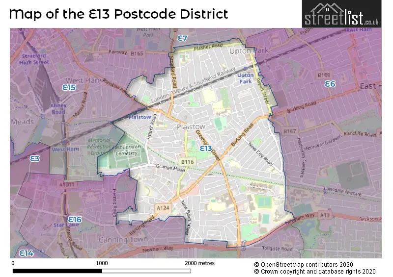
The largest settlements in the E13 postal code are PLAISTOW and UPTON PARK.
The E13 Postcode shares a border with E6 (EAST HAM, BECKTON), E16 (CANNING TOWN, NORTH WOOLWICH, SILVERTOWN), E7 (FOREST GATE) and E15 (STRATFORD).
The primary settlement in the E13 postcode district is Newham, located in the county of Greater London. Newham has the highest count of postcodes in this district.
For the district E13, we have data on 4 postcode sectors. Here's a breakdown: The sector E13 0, covers Newham in Greater London. The sector E13 3 is non-geographic. It's often designated for PO Boxes, large organisations, or special services. The sector E13 8, covers Newham in Greater London. The sector E13 9, covers Newham in Greater London.

Map of the E13 Postcode District
Explore the E13 postcode district by using our free interactive map.
When it comes to local government, postal geography often disregards political borders. However, for a breakdown in the E13 District: the district mostly encompasses the Newham London Boro area with a total of 573 postcodes.
Recent House Sales in E13
| Date | Price | Address |
|---|---|---|
| 19/10/2023 | £275,000 | Caraway Close, London, E13 8PN |
| 08/09/2023 | £447,000 | St Marys Road, London, E13 9AD |
| 04/09/2023 | £420,000 | Holborn Road, London, E13 8PA |
| 31/08/2023 | £550,000 | Green Street, London, E13 9AU |
| 31/08/2023 | £375,000 | Stopford Road, London, E13 0LZ |
| 31/08/2023 | £386,000 | Helena Road, London, E13 0DU |
| 30/08/2023 | £275,000 | Falcon Street, London, E13 8DD |
| 18/08/2023 | £385,000 | Coronation Road, London, E13 9QB |
| 17/08/2023 | £464,000 | Thorngrove Road, London, E13 0SJ |
| 11/08/2023 | £386,050 | Selby Road, London, E13 8NB |
Weather Forecast for E13
Press Button to Show Forecast for West Ham United F.C.
| Time Period | Icon | Description | Temperature | Rain Probability | Wind |
|---|---|---|---|---|---|
| 06:00 to 09:00 | Overcast | 6.0°C (feels like 6.0°C) | 11.00% | NNW 2 mph | |
| 09:00 to 12:00 | Light rain | 7.0°C (feels like 6.0°C) | 46.00% | W 4 mph | |
| 12:00 to 15:00 | Overcast | 8.0°C (feels like 7.0°C) | 21.00% | NW 7 mph | |
| 15:00 to 18:00 | Cloudy | 10.0°C (feels like 8.0°C) | 47.00% | N 9 mph | |
| 18:00 to 21:00 | Cloudy | 10.0°C (feels like 8.0°C) | 10.00% | N 9 mph | |
| 21:00 to 00:00 | Cloudy | 8.0°C (feels like 6.0°C) | 5.00% | N 7 mph |
Press Button to Show Forecast for West Ham United F.C.
| Time Period | Icon | Description | Temperature | Rain Probability | Wind |
|---|---|---|---|---|---|
| 00:00 to 03:00 | Overcast | 7.0°C (feels like 5.0°C) | 8.00% | NNW 7 mph | |
| 03:00 to 06:00 | Cloudy | 6.0°C (feels like 3.0°C) | 5.00% | NNW 7 mph | |
| 06:00 to 09:00 | Overcast | 5.0°C (feels like 3.0°C) | 8.00% | NW 7 mph | |
| 09:00 to 12:00 | Overcast | 7.0°C (feels like 5.0°C) | 9.00% | NNW 11 mph | |
| 12:00 to 15:00 | Overcast | 9.0°C (feels like 6.0°C) | 9.00% | NNW 11 mph | |
| 15:00 to 18:00 | Cloudy | 10.0°C (feels like 7.0°C) | 7.00% | NNW 11 mph | |
| 18:00 to 21:00 | Cloudy | 9.0°C (feels like 7.0°C) | 7.00% | N 9 mph | |
| 21:00 to 00:00 | Cloudy | 7.0°C (feels like 5.0°C) | 7.00% | NNW 7 mph |
Press Button to Show Forecast for West Ham United F.C.
| Time Period | Icon | Description | Temperature | Rain Probability | Wind |
|---|---|---|---|---|---|
| 00:00 to 03:00 | Clear night | 5.0°C (feels like 3.0°C) | 3.00% | NNW 7 mph | |
| 03:00 to 06:00 | Cloudy | 5.0°C (feels like 2.0°C) | 5.00% | NW 7 mph | |
| 06:00 to 09:00 | Partly cloudy (day) | 5.0°C (feels like 3.0°C) | 2.00% | NW 7 mph | |
| 09:00 to 12:00 | Overcast | 8.0°C (feels like 6.0°C) | 10.00% | NNW 9 mph | |
| 12:00 to 15:00 | Overcast | 10.0°C (feels like 8.0°C) | 12.00% | NNW 7 mph | |
| 15:00 to 18:00 | Cloudy | 11.0°C (feels like 9.0°C) | 10.00% | NNW 7 mph | |
| 18:00 to 21:00 | Cloudy | 10.0°C (feels like 9.0°C) | 11.00% | NNW 7 mph | |
| 21:00 to 00:00 | Cloudy | 8.0°C (feels like 7.0°C) | 8.00% | ENE 7 mph |
Press Button to Show Forecast for West Ham United F.C.
| Time Period | Icon | Description | Temperature | Rain Probability | Wind |
|---|---|---|---|---|---|
| 00:00 to 03:00 | Partly cloudy (night) | 7.0°C (feels like 5.0°C) | 2.00% | NE 4 mph | |
| 03:00 to 06:00 | Cloudy | 6.0°C (feels like 4.0°C) | 6.00% | E 4 mph | |
| 06:00 to 09:00 | Cloudy | 6.0°C (feels like 5.0°C) | 6.00% | ESE 4 mph | |
| 09:00 to 12:00 | Cloudy | 9.0°C (feels like 8.0°C) | 7.00% | ESE 7 mph | |
| 12:00 to 15:00 | Cloudy | 11.0°C (feels like 10.0°C) | 9.00% | SE 7 mph | |
| 15:00 to 18:00 | Cloudy | 12.0°C (feels like 11.0°C) | 14.00% | SE 7 mph | |
| 18:00 to 21:00 | Cloudy | 12.0°C (feels like 10.0°C) | 14.00% | SE 7 mph | |
| 21:00 to 00:00 | Cloudy | 10.0°C (feels like 8.0°C) | 9.00% | SSE 7 mph |
Where is the E13 Postcode District?
The postcode district E13 is located in London, specifically in the town of Plaistow. It is near several other towns within the city, including Upton Park, Canning Town, West Beckton, Forest Gate, Stratford, Silvertown, and East Ham. The distance from the E13 district to the center of London is approximately 6.81 miles.
The district is within the post town of LONDON.
The sector has postcodes within the nation of England.
The E13 Postcode District is in the Hackney and Newham region of Inner London - East within the London.
You may be interested in our page explaining the evolution of London's Postcodes| Postcode Sector | Delivery Office |
|---|---|
| E13 0 | Plaistow Sdelivery Office |
| E13 8 | Plaistow Sdelivery Office |
| E13 9 | Plaistow Sdelivery Office |
| E | 1 | 3 | - | X | X | X |
| E | 1 | 3 | Space | Numeric | Letter | Letter |
Current Monthly Rental Prices
| # Bedrooms | Min Price | Max Price | Avg Price |
|---|---|---|---|
| £758 | £758 | £758 | |
| 1 | £725 | £2,100 | £1,586 |
| 2 | £1,650 | £2,455 | £2,008 |
| 3 | £1,900 | £3,000 | £2,421 |
| 4 | £2,400 | £5,700 | £3,248 |
| 5 | £4,500 | £4,500 | £4,500 |
Current House Prices
| # Bedrooms | Min Price | Max Price | Avg Price |
|---|---|---|---|
| £305,000 | £799,000 | £552,000 | |
| 1 | £108,000 | £530,000 | £305,382 |
| 2 | £101,500 | £565,000 | £370,584 |
| 3 | £280,000 | £620,000 | £456,152 |
| 4 | £499,999 | £1,175,000 | £611,154 |
| 5 | £525,000 | £680,000 | £606,000 |
Estate Agents who Operate in the E13 District
| Logo | Name | Brand Name | Address | Contact Number | Total Properties |
|---|---|---|---|---|---|
 | Plaistow | Hunters | 272 Barking Road, London, E13 8HR | 020 3889 9111 | 17 |
 | Stratford | Foxtons | 9 The Grove, London, E15 1EL | 020 3909 4203 | 14 |
 | covering Plaistow | haart | Plaistow | 020 3910 6781 | 14 |
 | East Ham | Douglas Allen | 160 High Street North, East Ham, London, E6 2HT | 020 3871 1986 | 12 |
 | Plaistow | Reeds Rains | 286-288 Barking Road, London, E13 8HR | 020 3907 2697 | 8 |
| Type of Property | 2018 Average | 2018 Sales | 2017 Average | 2017 Sales | 2016 Average | 2016 Sales | 2015 Average | 2015 Sales |
|---|---|---|---|---|---|---|---|---|
| Detached | £1,030,000 | 1 | £510,667 | 3 | £608,333 | 3 | £456,667 | 3 |
| Semi-Detached | £451,500 | 7 | £460,938 | 8 | £471,375 | 4 | £352,090 | 11 |
| Terraced | £401,964 | 162 | £395,849 | 195 | £366,756 | 220 | £320,896 | 231 |
| Flats | £357,536 | 215 | £252,923 | 133 | £248,642 | 134 | £217,728 | 159 |