The EN10 postcode district is a postal district located in the EN Enfield postcode area with a population of 18,059 residents according to the 2021 England and Wales Census.
The area of the EN10 postcode district is 6.64 square miles which is 17.20 square kilometres or 4,250.03 acres.
Currently, the EN10 district has about 420 postcode units spread across 2 geographic postcode sectors.
Given that each sector allows for 400 unique postcode combinations, the district has a capacity of 800 postcodes. With 420 postcodes already in use, this leaves 380 units available.
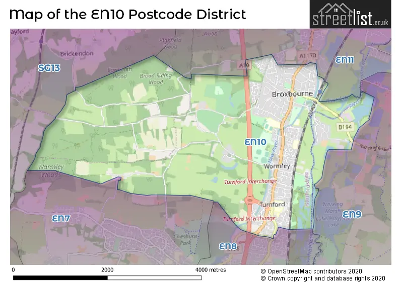
The largest settlement in the EN10 postal code is BROXBOURNE followed by Turnford, and Wormley.
The EN10 Postcode shares a border with SG13 (HERTFORD, Hertford Heath, Bayford), EN11 (HODDESDON), EN7 (CHESHUNT, GOFFS OAK), EN8 (CHESHUNT, WALTHAM CROSS) and EN9 (WALTHAM ABBEY).
The primary settlement in the EN10 postcode district is Broxbourne, which is located in the county of Hertfordshire in England. Other notable settlements in this district include Turnford and Wormley. The most significant post town in the district is also Broxbourne.
For the district EN10, we have data on 2 postcode sectors. Here's a breakdown: The sector EN10 6, covers Broxbourne in Hertfordshire. The sector EN10 6, covers Broxbourne in Essex. The sector EN10 7, covers Broxbourne in Hertfordshire.


Map of the EN10 Postcode District
Explore the EN10 postcode district by using our free interactive map.
When it comes to local government, postal geography often disregards political borders. However, for a breakdown in the EN10 District: the district mostly encompasses the Broxbourne District (B) (388 postcodes), followed by the Epping Forest District area (35 postcodes), and finally, the East Hertfordshire District area (8 postcodes).
Recent House Sales in EN10
| Date | Price | Address |
|---|---|---|
| 13/10/2023 | £244,000 | Sorbus Road, Turnford, Broxbourne, EN10 6GD |
| 29/09/2023 | £440,000 | Monson Road, Broxbourne, EN10 7DY |
| 15/09/2023 | £547,500 | Westlea Road, Wormley, Broxbourne, EN10 6JD |
| 01/09/2023 | £600,000 | Springfields, Broxbourne, EN10 7LX |
| 01/09/2023 | £264,995 | The Canadas, Broxbourne, EN10 6DP |
| 01/09/2023 | £270,000 | Winnipeg Way, Turnford, Broxbourne, EN10 6FH |
| 01/09/2023 | £265,000 | High Road, Broxbourne, EN10 7BN |
| 30/08/2023 | £900,000 | Pulham Avenue, Broxbourne, EN10 7TB |
| 29/08/2023 | £2,110,000 | Park Lane, Broxbourne, EN10 7PG |
| 25/08/2023 | £599,000 | High Road, Broxbourne, EN10 6QF |
Weather Forecast for EN10
Press Button to Show Forecast for Hoddesdon
| Time Period | Icon | Description | Temperature | Rain Probability | Wind |
|---|---|---|---|---|---|
| 12:00 to 15:00 | Light rain | 10.0°C (feels like 8.0°C) | 53.00% | WNW 11 mph | |
| 15:00 to 18:00 | Light rain | 10.0°C (feels like 8.0°C) | 50.00% | WNW 9 mph | |
| 18:00 to 21:00 | Cloudy | 8.0°C (feels like 6.0°C) | 9.00% | NNE 7 mph | |
| 21:00 to 00:00 | Cloudy | 6.0°C (feels like 5.0°C) | 7.00% | NE 4 mph |
Press Button to Show Forecast for Hoddesdon
| Time Period | Icon | Description | Temperature | Rain Probability | Wind |
|---|---|---|---|---|---|
| 00:00 to 03:00 | Cloudy | 5.0°C (feels like 3.0°C) | 4.00% | NE 4 mph | |
| 03:00 to 06:00 | Partly cloudy (night) | 3.0°C (feels like 1.0°C) | 5.00% | NE 4 mph | |
| 06:00 to 09:00 | Sunny day | 3.0°C (feels like 1.0°C) | 1.00% | NNE 4 mph | |
| 09:00 to 12:00 | Partly cloudy (day) | 8.0°C (feels like 6.0°C) | 1.00% | ENE 7 mph | |
| 12:00 to 15:00 | Cloudy | 10.0°C (feels like 9.0°C) | 9.00% | ENE 4 mph | |
| 15:00 to 18:00 | Overcast | 11.0°C (feels like 10.0°C) | 12.00% | NE 4 mph | |
| 18:00 to 21:00 | Cloudy | 9.0°C (feels like 8.0°C) | 10.00% | ENE 7 mph | |
| 21:00 to 00:00 | Cloudy | 6.0°C (feels like 4.0°C) | 9.00% | E 7 mph |
Press Button to Show Forecast for Hoddesdon
| Time Period | Icon | Description | Temperature | Rain Probability | Wind |
|---|---|---|---|---|---|
| 00:00 to 03:00 | Cloudy | 5.0°C (feels like 3.0°C) | 11.00% | ENE 4 mph | |
| 03:00 to 06:00 | Light rain | 4.0°C (feels like 2.0°C) | 44.00% | ENE 7 mph | |
| 06:00 to 09:00 | Cloudy | 5.0°C (feels like 2.0°C) | 19.00% | NE 7 mph | |
| 09:00 to 12:00 | Cloudy | 9.0°C (feels like 7.0°C) | 19.00% | ENE 9 mph | |
| 12:00 to 15:00 | Overcast | 11.0°C (feels like 9.0°C) | 19.00% | E 9 mph | |
| 15:00 to 18:00 | Cloudy | 12.0°C (feels like 10.0°C) | 18.00% | E 11 mph | |
| 18:00 to 21:00 | Cloudy | 11.0°C (feels like 9.0°C) | 23.00% | ENE 9 mph | |
| 21:00 to 00:00 | Light rain | 9.0°C (feels like 6.0°C) | 51.00% | NE 11 mph |
Press Button to Show Forecast for Hoddesdon
| Time Period | Icon | Description | Temperature | Rain Probability | Wind |
|---|---|---|---|---|---|
| 00:00 to 03:00 | Light rain | 9.0°C (feels like 6.0°C) | 51.00% | NE 9 mph | |
| 03:00 to 06:00 | Heavy rain | 9.0°C (feels like 7.0°C) | 75.00% | ESE 9 mph | |
| 06:00 to 09:00 | Light rain | 9.0°C (feels like 7.0°C) | 52.00% | SE 9 mph | |
| 09:00 to 12:00 | Heavy rain shower (day) | 11.0°C (feels like 9.0°C) | 58.00% | ESE 9 mph | |
| 12:00 to 15:00 | Light rain | 12.0°C (feels like 10.0°C) | 55.00% | S 9 mph | |
| 15:00 to 18:00 | Light rain shower (day) | 13.0°C (feels like 11.0°C) | 39.00% | SSW 11 mph | |
| 18:00 to 21:00 | Cloudy | 12.0°C (feels like 10.0°C) | 15.00% | SW 11 mph | |
| 21:00 to 00:00 | Partly cloudy (night) | 9.0°C (feels like 7.0°C) | 5.00% | SW 9 mph |
Where is the EN10 Postcode District?
The postcode district EN10 is located in the town of Broxbourne. It is situated near several towns, including Hoddesdon to the east (1.01 miles), Turnford to the southeast (1.34 miles), Cheshunt to the south (2.05 miles), Goffs Oak to the southwest (2.79 miles), Hertford to the northwest (3.23 miles), and Roydon to the northeast (4.29 miles). Additionally, the district is approximately 16.38 miles away from the center of London.
The district is within the post town of BROXBOURNE.
The sector has postcodes within the nation of England.
The EN10 Postcode District is covers the following regions.
- Hertfordshire - Bedfordshire and Hertfordshire - East of England
- West Essex - Essex - East of England
| Postcode Sector | Delivery Office |
|---|---|
| EN10 6 | Hoddesdon Delivery Office |
| EN10 7 | Hoddesdon Delivery Office |
| E | N | 1 | 0 | - | X | X | X |
| E | N | 1 | 0 | Space | Numeric | Letter | Letter |
Tourist Attractions within the Postcode Area
We found 1 visitor attractions within the EN10 postcode area
| Priest's House |
|---|
| Historic Properties |
| Historic House / House and Garden / Palace |
| View Priest's House on Google Maps |
Current Monthly Rental Prices
| # Bedrooms | Min Price | Max Price | Avg Price |
|---|---|---|---|
| £999 | £999 | £999 | |
| 1 | £999 | £1,150 | £1,065 |
| 2 | £1,300 | £1,950 | £1,489 |
| 3 | £2,000 | £2,000 | £2,000 |
| 4 | £1,950 | £3,200 | £2,813 |
| 5 | £2,425 | £6,000 | £3,625 |
| 8 | £8,999 | £8,999 | £8,999 |
Current House Prices
| # Bedrooms | Min Price | Max Price | Avg Price |
|---|---|---|---|
| £2,000 | £1,395,000 | £371,400 | |
| 1 | £95,000 | £250,000 | £206,187 |
| 2 | £180,000 | £635,000 | £294,431 |
| 3 | £260,000 | £1,000,000 | £526,700 |
| 4 | £439,995 | £1,950,000 | £799,978 |
| 5 | £735,000 | £2,000,000 | £1,133,571 |
| 6 | £899,995 | £2,150,000 | £1,274,999 |
| 7 | £1,800,000 | £1,800,000 | £1,800,000 |
| 23 | £1,300,000 | £1,300,000 | £1,300,000 |
Estate Agents who Operate in the EN10 District
| Logo | Name | Brand Name | Address | Contact Number | Total Properties |
|---|---|---|---|---|---|
 | Broxbourne | William H. Brown | 47 High Road, Broxbourne, EN10 7HX | 01992 662137 | 36 |
 | Hertfordshire | Westwood Leber | 8 The Pavilion Tower Centre Hoddesdon EN11 8UD | 01992 927906 | 21 |
 | Hoddesdon | Paul Wallace Estate Agents | 70 High Street, Hoddesdon, EN11 8ET | 01992 929602 | 16 |
 | Hoddesdon | Kirby Colletti | 64 High Street, Hoddesdon, EN11 8ET | 01992 471888 | 15 |
 | Broxbourne | Reynolds Salter | 25a High Road, Broxbourne, EN10 7HX | 01992 929629 | 14 |
| Type of Property | 2018 Average | 2018 Sales | 2017 Average | 2017 Sales | 2016 Average | 2016 Sales | 2015 Average | 2015 Sales |
|---|---|---|---|---|---|---|---|---|
| Detached | £764,689 | 44 | £725,194 | 49 | £840,932 | 66 | £656,539 | 75 |
| Semi-Detached | £474,198 | 53 | £492,749 | 40 | £525,920 | 44 | £445,092 | 59 |
| Terraced | £360,860 | 82 | £377,087 | 74 | £352,175 | 78 | £311,130 | 72 |
| Flats | £226,118 | 99 | £241,806 | 111 | £218,288 | 123 | £191,283 | 121 |