The EN2 postcode district is a postal district located in the EN Enfield postcode area with a population of 31,275 residents according to the 2021 England and Wales Census.
The area of the EN2 postcode district is 8.14 square miles which is 21.08 square kilometres or 5,210.12 acres.
Currently, the EN2 district has about 830 postcode units spread across 5 geographic postcode sectors.
Given that each sector allows for 400 unique postcode combinations, the district has a capacity of 2,000 postcodes. With 830 postcodes already in use, this leaves 1170 units available.
The EN2 postal code covers the settlement of ENFIELD.
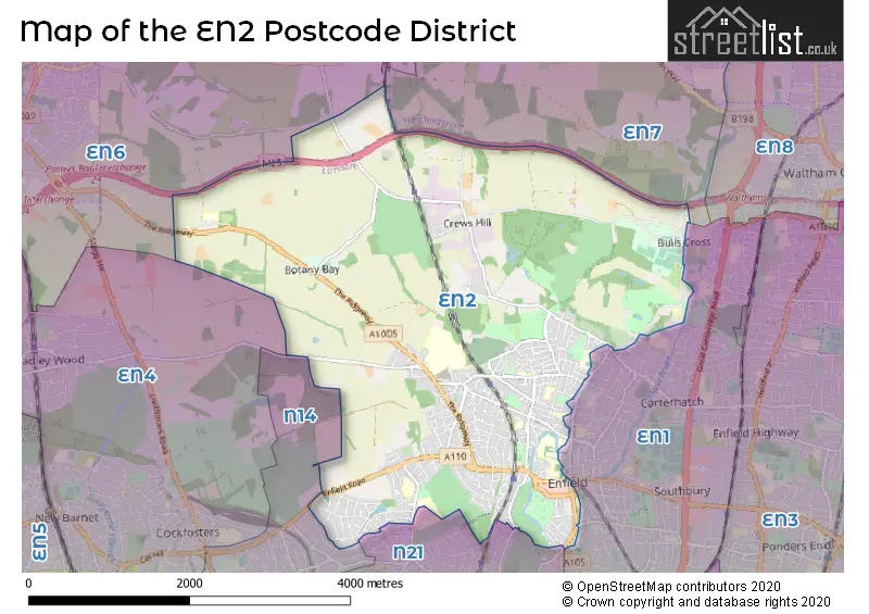
The EN2 Postcode shares a border with EN7 (CHESHUNT, GOFFS OAK), EN1 (ENFIELD), N14 (SOUTHGATE, NEW SOUTHGATE) and N21 (SOUTHGATE).
The primary settlement in the EN2 postcode district is Enfield, which is located in Greater London. The most significant Postal Town in this district is also Enfield. Additionally, there is a small proportion of the data that represents another settlement called The Ridgeway. In terms of counties, the district includes Greater London and Hertfordshire, although Hertfordshire represents a small proportion of the data.
For the district EN2, we have data on 5 postcode sectors. Here's a breakdown: The sector EN2 0, covers Enfield in Greater London. The sector EN2 6, covers Enfield in Greater London. The sector EN2 7, covers Enfield in Greater London. The sector EN2 8, covers Enfield in Greater London. The sector EN2 9, covers Enfield in Greater London.

Map of the EN2 Postcode District
Explore the EN2 postcode district by using our free interactive map.
When it comes to local government, postal geography often disregards political borders. However, for a breakdown in the EN2 District: the district mostly encompasses the Enfield London Boro area with a total of 825 postcodes.
Recent House Sales in EN2
| Date | Price | Address |
|---|---|---|
| 19/10/2023 | £265,000 | Cavell Drive, Enfield, EN2 7PR |
| 15/09/2023 | £870,000 | The Ridgeway, Enfield, EN2 8SF |
| 15/09/2023 | £1,650,000 | Rossendale Close, Enfield, EN2 9JQ |
| 12/09/2023 | £990,000 | Ridge Crest, Enfield, EN2 8JU |
| 08/09/2023 | £235,000 | Chase Court Gardens, Enfield, EN2 8DJ |
| 08/09/2023 | £450,000 | Chase Green, Enfield, EN2 6SD |
| 08/09/2023 | £525,000 | The Grove, Enfield, EN2 7PY |
| 06/09/2023 | £490,000 | Lea Road, Enfield, EN2 0LA |
| 01/09/2023 | £365,000 | Gordon Hill, Enfield, EN2 0QP |
| 01/09/2023 | £735,000 | Chase Side Avenue, Enfield, EN2 6JN |
Weather Forecast for EN2
Press Button to Show Forecast for Enfield
| Time Period | Icon | Description | Temperature | Rain Probability | Wind |
|---|---|---|---|---|---|
| 21:00 to 00:00 | Cloudy | 7.0°C (feels like 5.0°C) | 4.00% | N 7 mph |
Press Button to Show Forecast for Enfield
| Time Period | Icon | Description | Temperature | Rain Probability | Wind |
|---|---|---|---|---|---|
| 00:00 to 03:00 | Cloudy | 6.0°C (feels like 3.0°C) | 3.00% | NNW 7 mph | |
| 03:00 to 06:00 | Partly cloudy (night) | 5.0°C (feels like 2.0°C) | 0.00% | NNW 9 mph | |
| 06:00 to 09:00 | Cloudy | 5.0°C (feels like 2.0°C) | 4.00% | NNW 9 mph | |
| 09:00 to 12:00 | Cloudy | 8.0°C (feels like 5.0°C) | 4.00% | NNW 11 mph | |
| 12:00 to 15:00 | Overcast | 10.0°C (feels like 7.0°C) | 7.00% | NNW 11 mph | |
| 15:00 to 18:00 | Cloudy | 10.0°C (feels like 8.0°C) | 5.00% | N 11 mph | |
| 18:00 to 21:00 | Cloudy | 9.0°C (feels like 8.0°C) | 4.00% | N 7 mph | |
| 21:00 to 00:00 | Cloudy | 7.0°C (feels like 5.0°C) | 3.00% | NE 4 mph |
Press Button to Show Forecast for Enfield
| Time Period | Icon | Description | Temperature | Rain Probability | Wind |
|---|---|---|---|---|---|
| 00:00 to 03:00 | Cloudy | 6.0°C (feels like 5.0°C) | 4.00% | SW 4 mph | |
| 03:00 to 06:00 | Cloudy | 5.0°C (feels like 3.0°C) | 4.00% | WSW 7 mph | |
| 06:00 to 09:00 | Cloudy | 5.0°C (feels like 3.0°C) | 5.00% | W 7 mph | |
| 09:00 to 12:00 | Cloudy | 8.0°C (feels like 6.0°C) | 8.00% | W 9 mph | |
| 12:00 to 15:00 | Overcast | 10.0°C (feels like 8.0°C) | 15.00% | WNW 9 mph | |
| 15:00 to 18:00 | Overcast | 11.0°C (feels like 9.0°C) | 14.00% | WNW 9 mph | |
| 18:00 to 21:00 | Cloudy | 10.0°C (feels like 9.0°C) | 12.00% | NW 7 mph | |
| 21:00 to 00:00 | Cloudy | 8.0°C (feels like 6.0°C) | 8.00% | NNE 7 mph |
Press Button to Show Forecast for Enfield
| Time Period | Icon | Description | Temperature | Rain Probability | Wind |
|---|---|---|---|---|---|
| 00:00 to 03:00 | Cloudy | 6.0°C (feels like 5.0°C) | 5.00% | N 4 mph | |
| 03:00 to 06:00 | Cloudy | 5.0°C (feels like 3.0°C) | 5.00% | NE 4 mph | |
| 06:00 to 09:00 | Cloudy | 5.0°C (feels like 3.0°C) | 8.00% | ENE 4 mph | |
| 09:00 to 12:00 | Cloudy | 8.0°C (feels like 6.0°C) | 10.00% | ESE 7 mph | |
| 12:00 to 15:00 | Overcast | 11.0°C (feels like 9.0°C) | 16.00% | SE 7 mph | |
| 15:00 to 18:00 | Overcast | 11.0°C (feels like 9.0°C) | 22.00% | ESE 7 mph | |
| 18:00 to 21:00 | Cloudy | 10.0°C (feels like 8.0°C) | 18.00% | ESE 9 mph | |
| 21:00 to 00:00 | Cloudy | 9.0°C (feels like 7.0°C) | 17.00% | ESE 7 mph |
Press Button to Show Forecast for Enfield
| Time Period | Icon | Description | Temperature | Rain Probability | Wind |
|---|---|---|---|---|---|
| 00:00 to 03:00 | Cloudy | 8.0°C (feels like 6.0°C) | 19.00% | ESE 7 mph | |
| 03:00 to 06:00 | Cloudy | 7.0°C (feels like 6.0°C) | 21.00% | E 7 mph | |
| 06:00 to 09:00 | Overcast | 8.0°C (feels like 6.0°C) | 22.00% | E 7 mph | |
| 09:00 to 12:00 | Cloudy | 10.0°C (feels like 9.0°C) | 18.00% | SE 7 mph | |
| 12:00 to 15:00 | Light rain | 12.0°C (feels like 10.0°C) | 43.00% | ESE 9 mph | |
| 15:00 to 18:00 | Light rain | 13.0°C (feels like 11.0°C) | 51.00% | ESE 9 mph | |
| 18:00 to 21:00 | Light rain shower (day) | 12.0°C (feels like 11.0°C) | 34.00% | ESE 9 mph | |
| 21:00 to 00:00 | Cloudy | 11.0°C (feels like 9.0°C) | 17.00% | ESE 7 mph |
Where is the EN2 Postcode District?
The EN2 postcode district is located in Enfield, a district town in London. It is situated approximately 11.4 miles away from the center of London. The EN2 postcode district is surrounded by several nearby towns: Enfield North is located to the south, Goffs Oak is located to the north, Cockfosters is located to the southwest, and Northaw is located to the northwest.
The district is within the post town of ENFIELD.
The sector has postcodes within the nation of England.
The EN2 Postcode District is covers the following regions.
- Enfield - Outer London - East and North East - London
- Hertfordshire - Bedfordshire and Hertfordshire - East of England
| Postcode Sector | Delivery Office |
|---|---|
| EN2 0 | Enfield Delivery Office |
| EN2 6 | Enfield Delivery Office |
| EN2 7 | Enfield Delivery Office |
| EN2 8 | Enfield Delivery Office |
| EN2 9 | Enfield Delivery Office |
| E | N | 2 | - | X | X | X |
| E | N | 2 | Space | Numeric | Letter | Letter |
Current Monthly Rental Prices
| # Bedrooms | Min Price | Max Price | Avg Price |
|---|---|---|---|
| £160 | £2,750 | £1,252 | |
| 1 | £950 | £1,600 | £1,363 |
| 2 | £1,625 | £4,000 | £2,028 |
| 3 | £1,850 | £5,000 | £3,486 |
| 4 | £2,600 | £3,500 | £3,150 |
| 5 | £3,000 | £5,850 | £4,425 |
Current House Prices
| # Bedrooms | Min Price | Max Price | Avg Price |
|---|---|---|---|
| £10,000 | £1,200,000 | £290,909 | |
| 1 | £165,000 | £420,000 | £269,625 |
| 2 | £140,000 | £900,000 | £460,536 |
| 3 | £325,000 | £1,500,000 | £740,554 |
| 4 | £499,500 | £1,150,000 | £798,257 |
| 5 | £650,000 | £1,800,000 | £1,085,789 |
| 8 | £2,000,000 | £2,000,000 | £2,000,000 |
Estate Agents who Operate in the EN2 District
| Logo | Name | Brand Name | Address | Contact Number | Total Properties |
|---|---|---|---|---|---|
 | Enfield | Barnfields Estate Agents | 1a Windmill Hill Enfield EN2 6SE | 020 3907 9995 | 43 |
 | Enfield | Chamberlains | 47 Windmill Hill, Enfield, EN2 7AE | 020 3879 5188 | 14 |
 | Enfield | Ian Gibbs | 49-51 Windmill Hill, Enfield, EN2 7AE | 020 8370 4800 | 14 |
 | Winchmore Hill | Martyn Gerrard | 21 The Green, London, N21 3NL | 020 3835 4843 | 13 |
 | Enfield Town | Kings Group | 25, Silver Street, Enfield, EN1 3EF | 020 3869 0917 | 12 |
| Type of Property | 2018 Average | 2018 Sales | 2017 Average | 2017 Sales | 2016 Average | 2016 Sales | 2015 Average | 2015 Sales |
|---|---|---|---|---|---|---|---|---|
| Detached | £859,575 | 35 | £838,579 | 26 | £838,110 | 45 | £700,083 | 48 |
| Semi-Detached | £607,856 | 83 | £632,201 | 92 | £606,385 | 105 | £549,936 | 106 |
| Terraced | £490,400 | 127 | £502,312 | 113 | £488,397 | 144 | £435,443 | 130 |
| Flats | £317,379 | 178 | £334,219 | 176 | £325,320 | 250 | £299,354 | 287 |