The HA5 postcode district is a postal district located in the HA Harrow postcode area with a population of 47,084 residents according to the 2021 England and Wales Census.
The area of the HA5 postcode district is 5.27 square miles which is 13.64 square kilometres or 3,371.31 acres.
Currently, the HA5 district has about 1110 postcode units spread across 5 geographic postcode sectors.
Given that each sector allows for 400 unique postcode combinations, the district has a capacity of 2,000 postcodes. With 1110 postcodes already in use, this leaves 890 units available.
The largest settlements in the HA5 postal code are PINNER and EASTCOTE.
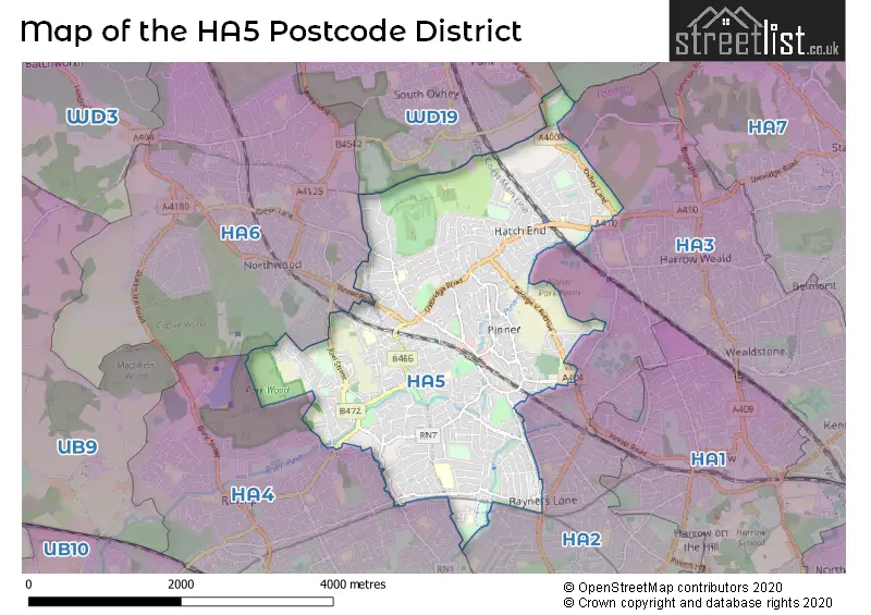
The HA5 Postcode shares a border with WD19 (SOUTH OXHEY, WATFORD, CARPENDERS PARK), HA4 (RUISLIP), HA6 (NORTHWOOD), HA2 (HARROW, SOUTH HARROW) and HA3 (HARROW).
In the HA5 postcode district, the primary settlement is Pinner located in Greater London. Other significant settlements include Eastcote in Greater London and Hatch End, also in Greater London. The primary post town for this district is Pinner. The county for the primary settlement and post town is Greater London.
For the district HA5, we have data on 6 postcode sectors. Here's a breakdown: The sector HA5 1, covers Pinner in Greater London. The sector HA5 2, covers Pinner in Greater London. The sector HA5 3, covers Pinner in Greater London. The sector HA5 4, covers Pinner in Greater London. The sector HA5 5, covers Pinner in Greater London. The sector HA5 9 is non-geographic. It's often designated for PO Boxes, large organisations, or special services.


Map of the HA5 Postcode District
Explore the HA5 postcode district by using our free interactive map.
When it comes to local government, postal geography often disregards political borders. However, for a breakdown in the HA5 District: the district mostly encompasses the Harrow London Boro (846 postcodes), and finally, the Hillingdon London Boro area (262 postcodes).
Recent House Sales in HA5
| Date | Price | Address |
|---|---|---|
| 30/10/2023 | £364,610 | Pinner Court, Pinner, HA5 5RL |
| 20/10/2023 | £130,000 | Uxbridge Road, Pinner, HA5 4JX |
| 04/10/2023 | £900,000 | Waxwell Lane, Pinner, HA5 3EL |
| 22/09/2023 | £765,000 | Curzon Place, Pinner, HA5 2TQ |
| 20/09/2023 | £660,000 | The Gardens, Pinner, HA5 5DW |
| 07/09/2023 | £615,000 | Wakehams Hill, Pinner, HA5 3BQ |
| 07/09/2023 | £450,000 | Oakwood Road, Pinner, HA5 3UE |
| 05/09/2023 | £521,000 | Derwent Avenue, Pinner, HA5 4QJ |
| 01/09/2023 | £1,130,000 | Barrow Point Avenue, Pinner, HA5 3HG |
| 01/09/2023 | £925,000 | Grove Road, Pinner, HA5 5HW |
Weather Forecast for HA5
Press Button to Show Forecast for Northwood
| Time Period | Icon | Description | Temperature | Rain Probability | Wind |
|---|---|---|---|---|---|
| 06:00 to 09:00 | Cloudy | 5.0°C (feels like 3.0°C) | 6.00% | WSW 7 mph | |
| 09:00 to 12:00 | Cloudy | 9.0°C (feels like 7.0°C) | 7.00% | W 9 mph | |
| 12:00 to 15:00 | Cloudy | 9.0°C (feels like 7.0°C) | 47.00% | W 11 mph | |
| 15:00 to 18:00 | Cloudy | 9.0°C (feels like 7.0°C) | 34.00% | WNW 9 mph | |
| 18:00 to 21:00 | Cloudy | 8.0°C (feels like 6.0°C) | 8.00% | NNE 4 mph | |
| 21:00 to 00:00 | Cloudy | 7.0°C (feels like 5.0°C) | 7.00% | NE 7 mph |
Press Button to Show Forecast for Northwood
| Time Period | Icon | Description | Temperature | Rain Probability | Wind |
|---|---|---|---|---|---|
| 00:00 to 03:00 | Cloudy | 6.0°C (feels like 3.0°C) | 5.00% | NE 7 mph | |
| 03:00 to 06:00 | Cloudy | 4.0°C (feels like 2.0°C) | 5.00% | NE 7 mph | |
| 06:00 to 09:00 | Cloudy | 4.0°C (feels like 1.0°C) | 5.00% | NE 7 mph | |
| 09:00 to 12:00 | Partly cloudy (day) | 7.0°C (feels like 5.0°C) | 2.00% | ENE 7 mph | |
| 12:00 to 15:00 | Cloudy | 10.0°C (feels like 8.0°C) | 10.00% | ENE 7 mph | |
| 15:00 to 18:00 | Overcast | 10.0°C (feels like 9.0°C) | 14.00% | ENE 4 mph | |
| 18:00 to 21:00 | Cloudy | 10.0°C (feels like 8.0°C) | 13.00% | NE 4 mph | |
| 21:00 to 00:00 | Cloudy | 7.0°C (feels like 4.0°C) | 11.00% | ENE 7 mph |
Press Button to Show Forecast for Northwood
| Time Period | Icon | Description | Temperature | Rain Probability | Wind |
|---|---|---|---|---|---|
| 00:00 to 03:00 | Cloudy | 5.0°C (feels like 3.0°C) | 10.00% | ENE 7 mph | |
| 03:00 to 06:00 | Cloudy | 4.0°C (feels like 2.0°C) | 18.00% | NE 7 mph | |
| 06:00 to 09:00 | Cloudy | 5.0°C (feels like 2.0°C) | 22.00% | NE 7 mph | |
| 09:00 to 12:00 | Cloudy | 9.0°C (feels like 6.0°C) | 17.00% | ENE 9 mph | |
| 12:00 to 15:00 | Overcast | 11.0°C (feels like 9.0°C) | 18.00% | E 9 mph | |
| 15:00 to 18:00 | Overcast | 12.0°C (feels like 10.0°C) | 22.00% | ENE 11 mph | |
| 18:00 to 21:00 | Light rain | 10.0°C (feels like 8.0°C) | 53.00% | ENE 9 mph | |
| 21:00 to 00:00 | Light rain | 9.0°C (feels like 6.0°C) | 55.00% | NE 11 mph |
Press Button to Show Forecast for Northwood
| Time Period | Icon | Description | Temperature | Rain Probability | Wind |
|---|---|---|---|---|---|
| 00:00 to 03:00 | Heavy rain | 8.0°C (feels like 6.0°C) | 75.00% | NE 11 mph | |
| 03:00 to 06:00 | Heavy rain | 8.0°C (feels like 6.0°C) | 75.00% | ENE 7 mph | |
| 06:00 to 09:00 | Light rain | 9.0°C (feels like 7.0°C) | 54.00% | ESE 7 mph | |
| 09:00 to 12:00 | Heavy rain | 10.0°C (feels like 8.0°C) | 78.00% | ESE 9 mph | |
| 12:00 to 15:00 | Light rain | 11.0°C (feels like 10.0°C) | 53.00% | SSE 9 mph | |
| 15:00 to 18:00 | Heavy rain shower (day) | 13.0°C (feels like 11.0°C) | 57.00% | SSW 11 mph | |
| 18:00 to 21:00 | Light rain shower (day) | 11.0°C (feels like 9.0°C) | 36.00% | WSW 11 mph | |
| 21:00 to 00:00 | Cloudy | 9.0°C (feels like 7.0°C) | 8.00% | SW 7 mph |
Where is the HA5 Postcode District?
The postcode district HA5 is located in Pinner, which is a town in the London Borough of Harrow. Pinner is situated in close proximity to several nearby towns. To the North East of Pinner is Hatch End, approximately 0.84 miles away. To the South West is Eastcote, approximately 0.97 miles away. To the South East is North Harrow, approximately 1.33 miles away. To the West is Northwood, approximately 1.83 miles away. To the South is Rayners Lane, approximately 1.83 miles away. To the North West is Northwood, approximately 1.91 miles away. Lastly, to the North is South Oxhey, approximately 1.91 miles away. Pinner is located about 12.78 miles away from the center of London.
The district is within the post town of PINNER.
The sector has postcodes within the nation of England.
The HA5 Postcode District is in the Harrow and Hillingdon region of Outer London - West and North West within the London.
| Postcode Sector | Delivery Office |
|---|---|
| HA5 1 | Pinner Delivery Office |
| HA5 2 | Pinner Delivery Office |
| HA5 3 | Pinner Delivery Office |
| HA5 4 | Pinner Delivery Office |
| HA5 5 | Pinner Delivery Office |
| H | A | 5 | - | X | X | X |
| H | A | 5 | Space | Numeric | Letter | Letter |
Current Monthly Rental Prices
| # Bedrooms | Min Price | Max Price | Avg Price |
|---|---|---|---|
| 1 | £1,250 | £2,167 | £1,619 |
| 2 | £1,450 | £3,250 | £1,931 |
| 3 | £1,650 | £5,634 | £2,796 |
| 4 | £2,500 | £8,667 | £4,663 |
| 5 | £3,850 | £10,833 | £5,572 |
Current House Prices
| # Bedrooms | Min Price | Max Price | Avg Price |
|---|---|---|---|
| £725,000 | £725,000 | £725,000 | |
| 1 | £100,000 | £525,000 | £257,746 |
| 2 | £70,000 | £830,000 | £468,808 |
| 3 | £325,000 | £2,295,000 | £748,864 |
| 4 | £450,000 | £1,500,000 | £967,226 |
| 5 | £800,000 | £2,795,000 | £1,344,998 |
| 6 | £875,000 | £3,500,000 | £1,729,167 |
Estate Agents who Operate in the HA5 District
| Logo | Name | Brand Name | Address | Contact Number | Total Properties |
|---|---|---|---|---|---|
 | Pinner | Robsons | 1 High Street Pinner HA5 5PJ | 020 8866 8083 | 60 |
 | Pinner Sales | Gibbs Gillespie | Pinn House, High Street, Pinner, Middlesex, HA5 5PW | 020 3910 6656 | 51 |
 | Pinner | Andrew Pearce | 9 Bridge Street, Pinner, HA5 3HR | 020 3907 3364 | 28 |
 | Pinner | Foxtons | 33-35 Bridge Street, Pinner, Middlesex HA5 3HR | 020 3834 8150 | 25 |
 | Pinner | David Charles | 34 High Street, Pinner, HA5 5PW | 020 3866 6789 | 16 |
| Type of Property | 2018 Average | 2018 Sales | 2017 Average | 2017 Sales | 2016 Average | 2016 Sales | 2015 Average | 2015 Sales |
|---|---|---|---|---|---|---|---|---|
| Detached | £882,137 | 118 | £888,033 | 110 | £940,411 | 112 | £884,529 | 164 |
| Semi-Detached | £676,823 | 145 | £699,817 | 169 | £681,425 | 177 | £601,130 | 202 |
| Terraced | £550,895 | 57 | £560,304 | 79 | £564,256 | 70 | £445,366 | 115 |
| Flats | £396,031 | 137 | £367,277 | 155 | £357,658 | 202 | £322,840 | 299 |