The HP1 postcode district is a postal district located in the HP Hemel Hempstead postcode area with a population of 26,280 residents according to the 2021 England and Wales Census.
The area of the HP1 postcode district is 9.27 square miles which is 24.01 square kilometres or 5,933.97 acres.
Currently, the HP1 district has about 662 postcode units spread across 28 geographic postcode sectors.
Given that each sector allows for 400 unique postcode combinations, the district has a capacity of 11,200 postcodes. With 662 postcodes already in use, this leaves 10538 units available.
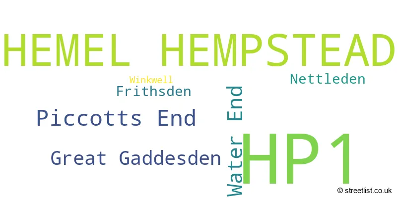
The largest settlement in the HP1 postal code is HEMEL HEMPSTEAD followed by Great Gaddesden, and Water End.
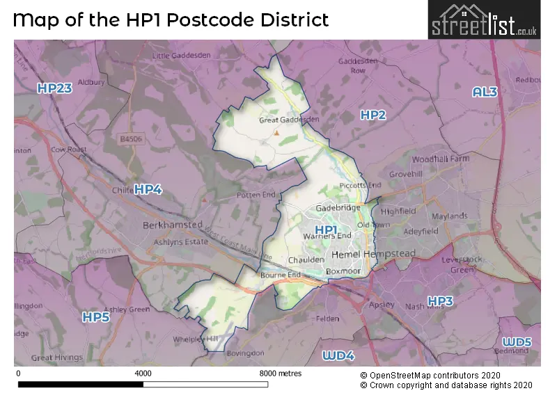
The HP1 Postcode shares a border with HP2 (HEMEL HEMPSTEAD, Hemel Hempstead Industrial Estate, Gaddesden Row), HP3 (HEMEL HEMPSTEAD, BOVINGDON, Felden), HP4 (BERKHAMSTED, Northchurch, Potten End) and HP5 (CHESHAM, Ashley Green, Bellingdon).
The HP1 postcode district in Hertfordshire, England, primarily consists of the settlement of Hemel Hempstead. There are also other significant settlements within HP1, including Winkwell, Frithsden, Great Gaddesden, Nettleden, Piccotts End, and Water End. Hemel Hempstead is the main post town in this area.
For the district HP1, we have data on 4 postcode sectors. Here's a breakdown: The sector HP1 1, covers Hemel Hempstead in Hertfordshire. The sector HP1 2, covers Hemel Hempstead in Hertfordshire. The sector HP1 3, covers Hemel Hempstead in Hertfordshire. The sector HP1 9 is non-geographic. It's often designated for PO Boxes, large organisations, or special services.

Map of the HP1 Postcode District
Explore the HP1 postcode district by using our free interactive map.
When it comes to local government, postal geography often disregards political borders. However, for a breakdown in the HP1 District: the district mostly encompasses the Dacorum District (B) area with a total of 673 postcodes.
Recent House Sales in HP18
| Date | Price | Address |
|---|---|---|
| 12/10/2023 | £608,000 | Thame Road, Long Crendon, Aylesbury, HP18 9AS |
| 29/09/2023 | £308,000 | Upende, Aylesbury, HP18 0FA |
| 29/09/2023 | £350,000 | Alma Street, Aylesbury, HP18 0FU |
| 27/09/2023 | £380,000 | Whitchurch Close, Westcott, Aylesbury, HP18 0PG |
| 22/09/2023 | £257,500 | The Lawns, Brill, Aylesbury, HP18 9SN |
| 22/09/2023 | £450,000 | Keepsake Way, Aylesbury, HP18 0XR |
| 12/09/2023 | £850,000 | Brill Road, Oakley, Aylesbury, HP18 9QH |
| 08/09/2023 | £445,000 | Linnet Drive, Westcott, Aylesbury, HP18 0PB |
| 01/09/2023 | £815,000 | The Green, Cuddington, Aylesbury, HP18 0AN |
| 31/08/2023 | £760,000 | Little Britain, Waddesdon, Aylesbury, HP18 0XA |
Weather Forecast for HP1
Press Button to Show Forecast for Hemel Hempstead
| Time Period | Icon | Description | Temperature | Rain Probability | Wind |
|---|---|---|---|---|---|
| 15:00 to 18:00 | Cloudy | 9.0°C (feels like 7.0°C) | 51.00% | WNW 9 mph | |
| 18:00 to 21:00 | Cloudy | 7.0°C (feels like 6.0°C) | 32.00% | NNE 7 mph | |
| 21:00 to 00:00 | Cloudy | 6.0°C (feels like 4.0°C) | 7.00% | ENE 4 mph |
Press Button to Show Forecast for Hemel Hempstead
| Time Period | Icon | Description | Temperature | Rain Probability | Wind |
|---|---|---|---|---|---|
| 00:00 to 03:00 | Cloudy | 4.0°C (feels like 2.0°C) | 4.00% | ENE 4 mph | |
| 03:00 to 06:00 | Clear night | 3.0°C (feels like 1.0°C) | 1.00% | NE 4 mph | |
| 06:00 to 09:00 | Partly cloudy (day) | 3.0°C (feels like 0.0°C) | 1.00% | NE 7 mph | |
| 09:00 to 12:00 | Partly cloudy (day) | 7.0°C (feels like 4.0°C) | 2.00% | ENE 7 mph | |
| 12:00 to 15:00 | Cloudy | 10.0°C (feels like 8.0°C) | 9.00% | ENE 7 mph | |
| 15:00 to 18:00 | Overcast | 10.0°C (feels like 9.0°C) | 13.00% | ENE 4 mph | |
| 18:00 to 21:00 | Cloudy | 9.0°C (feels like 8.0°C) | 10.00% | ENE 7 mph | |
| 21:00 to 00:00 | Cloudy | 6.0°C (feels like 4.0°C) | 11.00% | E 7 mph |
Press Button to Show Forecast for Hemel Hempstead
| Time Period | Icon | Description | Temperature | Rain Probability | Wind |
|---|---|---|---|---|---|
| 00:00 to 03:00 | Cloudy | 4.0°C (feels like 2.0°C) | 12.00% | ENE 7 mph | |
| 03:00 to 06:00 | Cloudy | 4.0°C (feels like 1.0°C) | 14.00% | ENE 7 mph | |
| 06:00 to 09:00 | Cloudy | 5.0°C (feels like 2.0°C) | 21.00% | NE 9 mph | |
| 09:00 to 12:00 | Overcast | 8.0°C (feels like 6.0°C) | 20.00% | ENE 9 mph | |
| 12:00 to 15:00 | Overcast | 11.0°C (feels like 9.0°C) | 20.00% | E 9 mph | |
| 15:00 to 18:00 | Overcast | 11.0°C (feels like 9.0°C) | 19.00% | ENE 11 mph | |
| 18:00 to 21:00 | Cloudy | 10.0°C (feels like 8.0°C) | 22.00% | ENE 9 mph | |
| 21:00 to 00:00 | Heavy rain | 8.0°C (feels like 5.0°C) | 73.00% | NE 11 mph |
Press Button to Show Forecast for Hemel Hempstead
| Time Period | Icon | Description | Temperature | Rain Probability | Wind |
|---|---|---|---|---|---|
| 00:00 to 03:00 | Heavy rain | 8.0°C (feels like 5.0°C) | 74.00% | NE 11 mph | |
| 03:00 to 06:00 | Heavy rain | 8.0°C (feels like 5.0°C) | 76.00% | NE 9 mph | |
| 06:00 to 09:00 | Light rain | 8.0°C (feels like 6.0°C) | 53.00% | SE 9 mph | |
| 09:00 to 12:00 | Light rain shower (day) | 10.0°C (feels like 8.0°C) | 44.00% | ESE 9 mph | |
| 12:00 to 15:00 | Heavy rain shower (day) | 11.0°C (feels like 9.0°C) | 63.00% | SE 9 mph | |
| 15:00 to 18:00 | Light rain shower (day) | 12.0°C (feels like 10.0°C) | 41.00% | SSE 11 mph | |
| 18:00 to 21:00 | Light rain shower (day) | 10.0°C (feels like 8.0°C) | 34.00% | WSW 11 mph | |
| 21:00 to 00:00 | Cloudy | 8.0°C (feels like 6.0°C) | 7.00% | SW 7 mph |
Where is the HP1 Postcode District?
The postcode district HP1 is located in the town of Hemel Hempstead. It is surrounded by several nearby towns, including Felden to the south, Berkhamsted to the west, Apsley to the southeast, and Whelpley Hill to the southwest. Hemel Hempstead is approximately 24.2 miles away from the center of London.
The district is within the post town of HEMEL HEMPSTEAD.
The sector has postcodes within the nation of England.
The HP1 Postcode District is in the Hertfordshire region of Bedfordshire and Hertfordshire within the East of England.
Postcode Sectors within the HP1 District
| Postcode Sector | Delivery Office |
|---|---|
| HP1 1 | Hemel Hempstead Delivery Office |
| HP1 2 | Hemel Hempstead Delivery Office |
| HP1 3 | Hemel Hempstead Delivery Office |
| H | P | 1 | - | X | X | X |
| H | P | 1 | Space | Numeric | Letter | Letter |
Current Monthly Rental Prices
| # Bedrooms | Min Price | Max Price | Avg Price |
|---|---|---|---|
| 1 | £768 | £1,395 | £1,038 |
| 2 | £1,300 | £1,575 | £1,412 |
| 3 | £1,295 | £1,850 | £1,683 |
| 4 | £2,100 | £2,100 | £2,100 |
Current House Prices
| # Bedrooms | Min Price | Max Price | Avg Price |
|---|---|---|---|
| £10,000 | £835,000 | £265,167 | |
| 1 | £53,750 | £285,000 | £206,875 |
| 2 | £130,000 | £800,000 | £342,647 |
| 3 | £180,000 | £900,000 | £486,159 |
| 4 | £400,000 | £1,250,000 | £686,082 |
| 5 | £530,000 | £685,000 | £607,500 |
| 6 | £800,000 | £930,000 | £865,000 |
| 7 | £835,000 | £1,750,000 | £1,292,500 |
| 10 | £2,950,000 | £2,950,000 | £2,950,000 |
Estate Agents who Operate in the HP1 District
| Logo | Name | Brand Name | Address | Contact Number | Total Properties |
|---|---|---|---|---|---|
 | Boxmoor | David Doyle Estate Agents | 45 St. Johns Road, Hemel Hempstead, HP1 1QQ | 01442 504076 | 58 |
 | Hemel Hempstead | Connells | 45 Marlowes, Hemel Hempstead, HP1 1LD | 01442 504014 | 20 |
 | Hemel Hempstead | Brown & Merry | 57 Marlowes Hemel Hempstead HP1 1LE | 01442 501568 | 19 |
 | Hemel Hempstead | Castles Estate Agents | 33 St Johns Road Boxmoor Hemel Hempstead Hertfordshire HP1 1QQ | 01442 504231 | 18 |
 | Hemel Hempstead | Squire Estates | 67 Marlowes Hemel Hempstead HP1 1LE | 01442 949990 | 10 |
| Type of Property | 2018 Average | 2018 Sales | 2017 Average | 2017 Sales | 2016 Average | 2016 Sales | 2015 Average | 2015 Sales |
|---|---|---|---|---|---|---|---|---|
| Detached | £677,476 | 52 | £611,313 | 56 | £639,133 | 40 | £555,593 | 69 |
| Semi-Detached | £453,773 | 56 | £454,248 | 75 | £461,815 | 50 | £387,168 | 66 |
| Terraced | £352,012 | 172 | £358,078 | 158 | £341,833 | 175 | £296,103 | 188 |
| Flats | £236,441 | 96 | £240,976 | 99 | £234,396 | 200 | £195,264 | 109 |