The HP12 postcode district is a postal district located in the HP Hemel Hempstead postcode area with a population of 23,283 residents according to the 2021 England and Wales Census.
The area of the HP12 postcode district is 3.97 square miles which is 10.27 square kilometres or 2,538.69 acres.
Currently, the HP12 district has about 501 postcode units spread across 2 geographic postcode sectors.
Given that each sector allows for 400 unique postcode combinations, the district has a capacity of 800 postcodes. With 501 postcodes already in use, this leaves 299 units available.
The largest settlement in the HP12 postal code is HIGH WYCOMBE followed by Cressex Business Park, and Sands Industrial Estate.
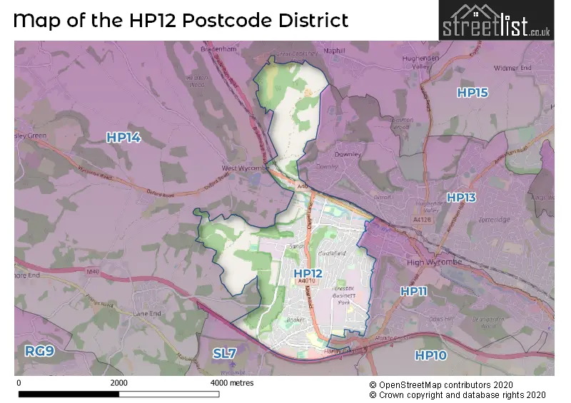
The HP12 Postcode shares a border with HP11 (HIGH WYCOMBE), HP14 (Stokenchurch, Lane End, Walters Ash) and SL7 (MARLOW, Medmenham, Booker).
The HP12 postcode district in Buckinghamshire, England, is primarily serviced by the town of High Wycombe. Other significant settlements in the district include Cressex Business Park, Booker, and the Sands Industrial Estate. High Wycombe is the most prominent post town in the district.
For the district HP12, we have data on 3 postcode sectors. Here's a breakdown: The sector HP12 3, covers High Wycombe and Cressex Business Park in Buckinghamshire. The sector HP12 4, covers High Wycombe in Buckinghamshire. The sector HP12 9 is non-geographic. It's often designated for PO Boxes, large organisations, or special services.

Map of the HP12 Postcode District
Explore the HP12 postcode district by using our free interactive map.
When it comes to local government, postal geography often disregards political borders. However, for a breakdown in the HP12 District: the district mostly encompasses the Buckinghamshire area with a total of 501 postcodes.
Recent House Sales in HP12
| Date | Price | Address |
|---|---|---|
| 20/09/2023 | £495,000 | Barbers Wood Close, High Wycombe, HP12 4EW |
| 12/09/2023 | £500,000 | Roundwood Road, High Wycombe, HP12 4HE |
| 08/09/2023 | £175,000 | Abercromby Avenue, High Wycombe, HP12 3BJ |
| 05/09/2023 | £540,000 | Chapel Lane, Sands, High Wycombe, HP12 4BS |
| 30/08/2023 | £491,000 | The Coppice, Booker, High Wycombe, HP12 4SA |
| 25/08/2023 | £420,000 | Pinewood Road, High Wycombe, HP12 4DA |
| 22/08/2023 | £147,500 | West Wycombe Road, High Wycombe, HP12 3AR |
| 18/08/2023 | £407,000 | Deeds Grove, High Wycombe, HP12 3PA |
| 15/08/2023 | £390,000 | Rutland Avenue, High Wycombe, HP12 3LX |
| 14/08/2023 | £195,000 | Castleview Gardens, High Wycombe, HP12 3UD |
Weather Forecast for HP12
Press Button to Show Forecast for West Wycombe Park
| Time Period | Icon | Description | Temperature | Rain Probability | Wind |
|---|---|---|---|---|---|
| 21:00 to 00:00 | Cloudy | 6.0°C (feels like 4.0°C) | 5.00% | ENE 7 mph |
Press Button to Show Forecast for West Wycombe Park
| Time Period | Icon | Description | Temperature | Rain Probability | Wind |
|---|---|---|---|---|---|
| 00:00 to 03:00 | Cloudy | 4.0°C (feels like 2.0°C) | 4.00% | ENE 4 mph | |
| 03:00 to 06:00 | Cloudy | 3.0°C (feels like 1.0°C) | 5.00% | ENE 4 mph | |
| 06:00 to 09:00 | Partly cloudy (day) | 3.0°C (feels like 0.0°C) | 2.00% | NE 7 mph | |
| 09:00 to 12:00 | Partly cloudy (day) | 7.0°C (feels like 4.0°C) | 2.00% | ENE 9 mph | |
| 12:00 to 15:00 | Overcast | 9.0°C (feels like 8.0°C) | 11.00% | ENE 7 mph | |
| 15:00 to 18:00 | Overcast | 10.0°C (feels like 9.0°C) | 14.00% | ENE 4 mph | |
| 18:00 to 21:00 | Cloudy | 9.0°C (feels like 8.0°C) | 12.00% | NE 4 mph | |
| 21:00 to 00:00 | Cloudy | 6.0°C (feels like 3.0°C) | 12.00% | ENE 7 mph |
Press Button to Show Forecast for West Wycombe Park
| Time Period | Icon | Description | Temperature | Rain Probability | Wind |
|---|---|---|---|---|---|
| 00:00 to 03:00 | Cloudy | 4.0°C (feels like 2.0°C) | 13.00% | ENE 7 mph | |
| 03:00 to 06:00 | Cloudy | 3.0°C (feels like 1.0°C) | 15.00% | ENE 7 mph | |
| 06:00 to 09:00 | Cloudy | 4.0°C (feels like 1.0°C) | 23.00% | ENE 9 mph | |
| 09:00 to 12:00 | Overcast | 8.0°C (feels like 5.0°C) | 21.00% | ENE 9 mph | |
| 12:00 to 15:00 | Overcast | 10.0°C (feels like 8.0°C) | 19.00% | E 9 mph | |
| 15:00 to 18:00 | Cloudy | 11.0°C (feels like 9.0°C) | 18.00% | ENE 11 mph | |
| 18:00 to 21:00 | Light rain | 10.0°C (feels like 7.0°C) | 52.00% | ENE 9 mph | |
| 21:00 to 00:00 | Light rain | 8.0°C (feels like 5.0°C) | 52.00% | NE 11 mph |
Press Button to Show Forecast for West Wycombe Park
| Time Period | Icon | Description | Temperature | Rain Probability | Wind |
|---|---|---|---|---|---|
| 00:00 to 03:00 | Heavy rain | 7.0°C (feels like 4.0°C) | 75.00% | NE 11 mph | |
| 03:00 to 06:00 | Heavy rain | 7.0°C (feels like 5.0°C) | 75.00% | NE 9 mph | |
| 06:00 to 09:00 | Light rain | 8.0°C (feels like 6.0°C) | 54.00% | ESE 7 mph | |
| 09:00 to 12:00 | Light rain shower (day) | 9.0°C (feels like 7.0°C) | 40.00% | ESE 9 mph | |
| 12:00 to 15:00 | Light rain | 11.0°C (feels like 9.0°C) | 55.00% | SSE 9 mph | |
| 15:00 to 18:00 | Light rain shower (day) | 12.0°C (feels like 9.0°C) | 41.00% | WSW 11 mph | |
| 18:00 to 21:00 | Light rain shower (day) | 10.0°C (feels like 7.0°C) | 31.00% | W 11 mph | |
| 21:00 to 00:00 | Cloudy | 8.0°C (feels like 6.0°C) | 8.00% | WSW 7 mph |
Where is the HP12 Postcode District?
The data is indicating that the postcode district for HP12 is located in High Wycombe. High Wycombe is surrounded by several nearby towns, including Marlow in the south, Bourne End in the southeast, Great Missenden in the northeast, Princes Risborough in the north, Chinnor in the northwest, Beaconsfield in the east, Henley-on-Thames in the southwest, and Watlington in the west. Additionally, High Wycombe is approximately 29.7 miles away from the center of London.
The district is within the post town of HIGH WYCOMBE.
The sector has postcodes within the nation of England.
The HP12 Postcode District is in the region of within the .
| Postcode Sector | Delivery Office |
|---|---|
| HP12 3 | High Wycombe South Postal Delivery Office |
| HP12 4 | High Wycombe South Postal Delivery Office |
| H | P | 1 | 2 | - | X | X | X |
| H | P | 1 | 2 | Space | Numeric | Letter | Letter |
Current Monthly Rental Prices
| # Bedrooms | Min Price | Max Price | Avg Price |
|---|---|---|---|
| £800 | £800 | £800 | |
| 1 | £500 | £2,000 | £1,100 |
| 2 | £1,100 | £1,600 | £1,303 |
| 3 | £1,395 | £1,800 | £1,598 |
| 4 | £498 | £1,995 | £1,599 |
| 18 | £10,000 | £10,000 | £10,000 |
Current House Prices
| # Bedrooms | Min Price | Max Price | Avg Price |
|---|---|---|---|
| £1 | £135,000 | £67,501 | |
| 1 | £139,950 | £295,000 | £197,407 |
| 2 | £110,000 | £440,000 | £258,984 |
| 3 | £300,000 | £650,000 | £438,957 |
| 4 | £350,000 | £1,250,000 | £630,286 |
| 5 | £400,000 | £900,000 | £583,333 |
| 6 | £750,000 | £750,000 | £750,000 |
| 7 | £685,000 | £685,000 | £685,000 |
Estate Agents who Operate in the HP12 District
| Logo | Name | Brand Name | Address | Contact Number | Total Properties |
|---|---|---|---|---|---|
 | High Wycombe | Hurst Estate Agents | 1 Crendon Street High Wycombe HP13 6LE | 01494 341019 | 20 |
 | High Wycombe | JNP | 27 Crendon Street High Wycombe HP13 6LJ | 01494 341322 | 16 |
 | High Wycombe | Chancellors | 2 Crendon Street, High Wycombe, HP13 6LW | 01494 321088 | 16 |
 | High Wycombe | Chiltern Hills | 19 Crendon Street, High Wycombe, HP13 6LJ | 01494 509216 | 11 |
 | High Wycombe | Connells | 1-3 Queen Victoria Road, High Wycombe, Buckinghamshire, HP11 1BA | 01494 341029 | 11 |
| Type of Property | 2018 Average | 2018 Sales | 2017 Average | 2017 Sales | 2016 Average | 2016 Sales | 2015 Average | 2015 Sales |
|---|---|---|---|---|---|---|---|---|
| Detached | £447,393 | 49 | £476,998 | 64 | £429,446 | 57 | £400,498 | 69 |
| Semi-Detached | £360,376 | 110 | £352,914 | 102 | £323,057 | 105 | £280,071 | 103 |
| Terraced | £275,527 | 33 | £303,775 | 55 | £267,249 | 52 | £253,012 | 58 |
| Flats | £219,151 | 73 | £213,401 | 109 | £194,485 | 128 | £168,373 | 100 |