The HU14 postcode district is a postal district located in the HU Hull postcode area with a population of 8,549 residents according to the 2021 England and Wales Census.
The area of the HU14 postcode district is 7.33 square miles which is 19.00 square kilometres or 4,693.81 acres.
Currently, the HU14 district has about 220 postcode units spread across 1 geographic postcode sectors.
Given that each sector allows for 400 unique postcode combinations, the district has a capacity of 400 postcodes. With 220 postcodes already in use, this leaves 180 units available.
The largest settlement in the HU14 postal code is Swanland followed by NORTH FERRIBY, and Melton.
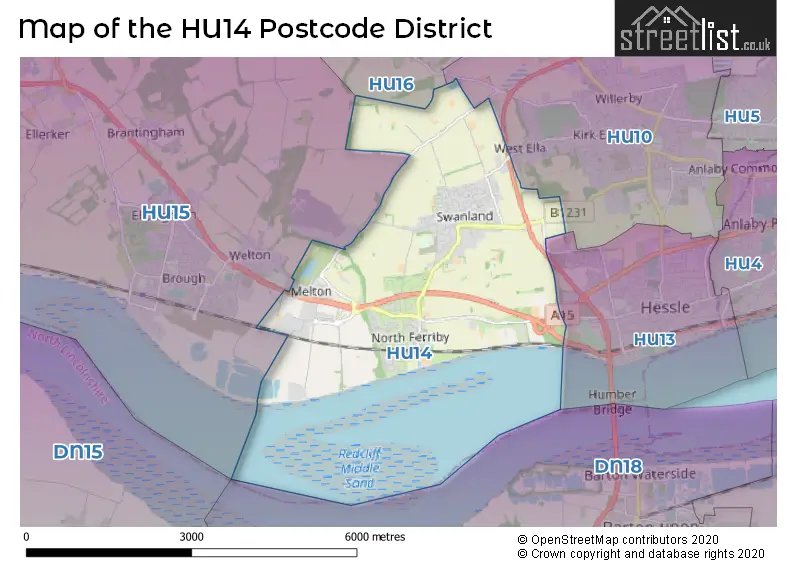
The postcode area has a boundary with The Humber.
The HU14 Postcode shares a border with HU15 (BROUGH, South Cave, Gilberdyke) and HU10 (Willerby, Anlaby, Kirk Ella).
The primary settlement in the HU14 postcode district is North Ferriby, located in the East Riding of Yorkshire. The most significant post town in this district is also North Ferriby. Other notable settlements in the district include Melton and Swanland, both also located in the East Riding of Yorkshire.
For the district HU14, we have data on 2 postcode sectors. Here's a breakdown: The sector HU14 3, covers North Ferriby and Swanland and Melton in East Riding of Yorkshire. The sector HU14 9 is non-geographic. It's often designated for PO Boxes, large organisations, or special services.
HU14 Postcode Sectors

Map of the HU14 Postcode District
Explore the HU14 postcode district by using our free interactive map.
When it comes to local government, postal geography often disregards political borders. However, for a breakdown in the HU14 District: the district mostly encompasses the East Riding of Yorkshire area with a total of 233 postcodes.
Recent House Sales in HU14
| Date | Price | Address |
|---|---|---|
| 29/09/2023 | £60,000 | Haldenby Court, Swanland, North Ferriby, HU14 3PQ |
| 28/09/2023 | £350,000 | Mill Rise, Swanland, North Ferriby, HU14 3PN |
| 22/09/2023 | £275,000 | Church Avenue, North Ferriby, HU14 3BY |
| 18/09/2023 | £530,000 | Hall Park, Swanland, North Ferriby, HU14 3NL |
| 01/09/2023 | £497,500 | The Paddock, Swanland, North Ferriby, HU14 3QW |
| 01/09/2023 | £169,950 | West View, North Ferriby, HU14 3AG |
| 29/08/2023 | £300,000 | The Rise, North Ferriby, HU14 3EG |
| 29/08/2023 | £350,000 | Nunburnholme Avenue, North Ferriby, HU14 3AN |
| 25/08/2023 | £600,000 | Styles Croft, Swanland, North Ferriby, HU14 3NU |
| 25/08/2023 | £875,000 | The Park, Swanland, North Ferriby, HU14 3LU |
Weather Forecast for HU14
Press Button to Show Forecast for South Field
| Time Period | Icon | Description | Temperature | Rain Probability | Wind |
|---|---|---|---|---|---|
| 06:00 to 09:00 | Partly cloudy (day) | 4.0°C (feels like 1.0°C) | 2.00% | NNW 9 mph | |
| 09:00 to 12:00 | Overcast | 7.0°C (feels like 3.0°C) | 9.00% | N 13 mph | |
| 12:00 to 15:00 | Overcast | 8.0°C (feels like 5.0°C) | 8.00% | N 13 mph | |
| 15:00 to 18:00 | Cloudy | 9.0°C (feels like 6.0°C) | 4.00% | N 11 mph | |
| 18:00 to 21:00 | Cloudy | 7.0°C (feels like 5.0°C) | 3.00% | NNE 9 mph | |
| 21:00 to 00:00 | Partly cloudy (night) | 5.0°C (feels like 3.0°C) | 1.00% | SSW 4 mph |
Press Button to Show Forecast for South Field
| Time Period | Icon | Description | Temperature | Rain Probability | Wind |
|---|---|---|---|---|---|
| 00:00 to 03:00 | Cloudy | 5.0°C (feels like 2.0°C) | 4.00% | WSW 9 mph | |
| 03:00 to 06:00 | Cloudy | 5.0°C (feels like 1.0°C) | 5.00% | WSW 11 mph | |
| 06:00 to 09:00 | Partly cloudy (day) | 5.0°C (feels like 1.0°C) | 4.00% | WNW 11 mph | |
| 09:00 to 12:00 | Cloudy | 7.0°C (feels like 4.0°C) | 9.00% | NW 11 mph | |
| 12:00 to 15:00 | Light rain shower (day) | 8.0°C (feels like 5.0°C) | 32.00% | NNW 9 mph | |
| 15:00 to 18:00 | Light rain shower (day) | 9.0°C (feels like 6.0°C) | 30.00% | N 9 mph | |
| 18:00 to 21:00 | Partly cloudy (day) | 7.0°C (feels like 5.0°C) | 4.00% | NNE 9 mph | |
| 21:00 to 00:00 | Clear night | 4.0°C (feels like 2.0°C) | 3.00% | N 4 mph |
Press Button to Show Forecast for South Field
| Time Period | Icon | Description | Temperature | Rain Probability | Wind |
|---|---|---|---|---|---|
| 00:00 to 03:00 | Partly cloudy (night) | 2.0°C (feels like 0.0°C) | 2.00% | N 4 mph | |
| 03:00 to 06:00 | Partly cloudy (night) | 2.0°C (feels like 0.0°C) | 3.00% | NW 4 mph | |
| 06:00 to 09:00 | Cloudy | 3.0°C (feels like 2.0°C) | 5.00% | N 4 mph | |
| 09:00 to 12:00 | Cloudy | 7.0°C (feels like 6.0°C) | 8.00% | NE 7 mph | |
| 12:00 to 15:00 | Overcast | 9.0°C (feels like 8.0°C) | 13.00% | E 7 mph | |
| 15:00 to 18:00 | Overcast | 9.0°C (feels like 7.0°C) | 13.00% | E 9 mph | |
| 18:00 to 21:00 | Cloudy | 8.0°C (feels like 6.0°C) | 11.00% | ESE 9 mph | |
| 21:00 to 00:00 | Cloudy | 6.0°C (feels like 4.0°C) | 10.00% | E 7 mph |
Press Button to Show Forecast for South Field
| Time Period | Icon | Description | Temperature | Rain Probability | Wind |
|---|---|---|---|---|---|
| 00:00 to 03:00 | Cloudy | 5.0°C (feels like 3.0°C) | 15.00% | ESE 7 mph | |
| 03:00 to 06:00 | Cloudy | 5.0°C (feels like 3.0°C) | 18.00% | E 7 mph | |
| 06:00 to 09:00 | Overcast | 6.0°C (feels like 4.0°C) | 21.00% | E 9 mph | |
| 09:00 to 12:00 | Cloudy | 9.0°C (feels like 6.0°C) | 21.00% | E 11 mph | |
| 12:00 to 15:00 | Cloudy | 10.0°C (feels like 8.0°C) | 20.00% | E 11 mph | |
| 15:00 to 18:00 | Light rain | 11.0°C (feels like 8.0°C) | 48.00% | ENE 11 mph | |
| 18:00 to 21:00 | Cloudy | 10.0°C (feels like 7.0°C) | 15.00% | E 11 mph | |
| 21:00 to 00:00 | Cloudy | 8.0°C (feels like 6.0°C) | 14.00% | ENE 9 mph |
Where is the HU14 Postcode District?
The postcode district HU14 is located in the town of North Ferriby. It is situated near several other towns: Hessle is to the east, Brough is to the west, Barton-upon-Humber is to the southeast, Cottingham is to the northeast, Beverley is to the north, and Scunthorpe is to the southwest. The district is approximately 154.58 miles away from the center of London.
The district is within the post town of NORTH FERRIBY.
The sector has postcodes within the nation of England.
The HU14 Postcode District is in the East Riding of Yorkshire region of East Yorkshire and Northern Lincolnshire within the Yorkshire and The Humber.
Postcode Sectors within the HU14 District
| Postcode Sector | Delivery Office |
|---|---|
| HU14 3 | Saxon Way Postal Delivery Office |
| H | U | 1 | 4 | - | X | X | X |
| H | U | 1 | 4 | Space | Numeric | Letter | Letter |
Current Monthly Rental Prices
| # Bedrooms | Min Price | Max Price | Avg Price |
|---|---|---|---|
| 2 | £780 | £1,100 | £940 |
| 3 | £900 | £1,200 | £1,033 |
| 4 | £2,750 | £2,750 | £2,750 |
| 5 | £2,550 | £2,550 | £2,550 |
| 6 | £2,200 | £2,200 | £2,200 |
Current House Prices
| # Bedrooms | Min Price | Max Price | Avg Price |
|---|---|---|---|
| £230,000 | £1,500,000 | £701,667 | |
| 1 | £60,000 | £85,000 | £67,400 |
| 2 | £53,750 | £465,000 | £221,408 |
| 3 | £185,000 | £550,000 | £309,465 |
| 4 | £249,950 | £1,000,000 | £468,562 |
| 5 | £375,000 | £1,350,000 | £709,991 |
| 6 | £1,250,000 | £1,250,000 | £1,250,000 |
Estate Agents who Operate in the HU14 District
| Logo | Name | Brand Name | Address | Contact Number | Total Properties |
|---|---|---|---|---|---|
 | Brough | Matthew Limb Estate Agents Ltd | Unit 2 Welton Road Retail Park Brough, HU15 1AF | 01482 251747 | 35 |
 | Swanland | Staniford Grays | 2 West End, Swanland, HU14 3PE | 01482 251722 | 14 |
 | North Ferriby | Beercocks | Church Road, North Ferriby, HU14 3BU | 01482 251698 | 9 |
 | Elloughton | Philip Bannister & Co | 1a Stockbridge Road, Elloughton, Brough, HU15 1HW | 01482 424767 | 4 |
 | Anlaby | Whitakers | 38 Wilson Street, Anlaby, HU10 7AN | 01482 424760 | 4 |
| Type of Property | 2018 Average | 2018 Sales | 2017 Average | 2017 Sales | 2016 Average | 2016 Sales | 2015 Average | 2015 Sales |
|---|---|---|---|---|---|---|---|---|
| Detached | £436,930 | 69 | £431,791 | 101 | £411,822 | 94 | £390,932 | 85 |
| Semi-Detached | £208,115 | 47 | £203,245 | 52 | £225,980 | 48 | £195,342 | 49 |
| Terraced | £164,017 | 15 | £172,150 | 13 | £162,727 | 13 | £172,242 | 24 |
| Flats | £166,218 | 8 | £147,878 | 9 | £110,400 | 5 | £79,300 | 5 |