The HX5 postcode district is a postal district located in the HX Halifax postcode area with a population of 10,537 residents according to the 2021 England and Wales Census.
The area of the HX5 postcode district is 2.80 square miles which is 7.25 square kilometres or 1,792.71 acres.
Currently, the HX5 district has about 298 postcode units spread across 2 geographic postcode sectors.
Given that each sector allows for 400 unique postcode combinations, the district has a capacity of 800 postcodes. With 298 postcodes already in use, this leaves 502 units available.
The largest settlements in the HX5 postal code are ELLAND and Lowfields Business Park.
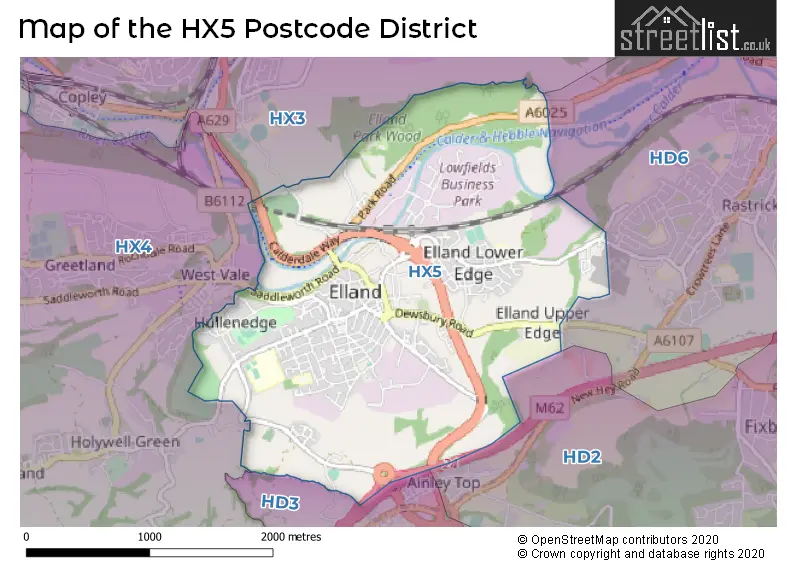
The HX5 Postcode shares a border with HD3 (HUDDERSFIELD, Longwood, Lindley), HD6 (BRIGHOUSE, Bailiff Bridge, Clifton), HX3 (HALIFAX, Hipperholme, Northowram) and HX4 (Greetland, Holywell Green, Barkisland).
The primary settlement in the HX5 postcode district is Elland, located in the county of West Yorkshire in England. The most significant post town in this district is Elland as well.
For the district HX5, we have data on 2 postcode sectors. Here's a breakdown: The sector HX5 0, covers Elland in West Yorkshire. The sector HX5 9, covers Elland in West Yorkshire.


Map of the HX5 Postcode District
Explore the HX5 postcode district by using our free interactive map.
When it comes to local government, postal geography often disregards political borders. However, for a breakdown in the HX5 District: the district mostly encompasses the Calderdale District (B) area with a total of 296 postcodes.
Recent House Sales in HX5
| Date | Price | Address |
|---|---|---|
| 02/10/2023 | £104,000 | Myrtle Road, Elland, HX5 0HU |
| 29/09/2023 | £190,000 | Savile Road, Elland, HX5 0NU |
| 11/09/2023 | £107,500 | Myrtle Road, Elland, HX5 0HU |
| 08/09/2023 | £146,250 | Victoria Road, Elland, HX5 0PL |
| 06/09/2023 | £212,500 | Laurel Close, Elland, HX5 0QD |
| 04/09/2023 | £147,500 | Banks End Road, Elland, HX5 9JZ |
| 25/08/2023 | £195,000 | Thomas Street, Elland, HX5 9BL |
| 22/08/2023 | £115,000 | Park Road, Elland, HX5 9GY |
| 18/08/2023 | £120,000 | Oak Street, Elland, HX5 0LF |
| 16/08/2023 | £119,000 | Langdale Street, Elland, HX5 0LZ |
Weather Forecast for HX5
Press Button to Show Forecast for Elland
| Time Period | Icon | Description | Temperature | Rain Probability | Wind |
|---|---|---|---|---|---|
| 09:00 to 12:00 | Cloudy | 6.0°C (feels like 2.0°C) | 10.00% | N 11 mph | |
| 12:00 to 15:00 | Cloudy | 7.0°C (feels like 5.0°C) | 15.00% | NNE 7 mph | |
| 15:00 to 18:00 | Cloudy | 8.0°C (feels like 7.0°C) | 8.00% | NNW 4 mph | |
| 18:00 to 21:00 | Cloudy | 7.0°C (feels like 5.0°C) | 6.00% | NE 7 mph | |
| 21:00 to 00:00 | Partly cloudy (night) | 5.0°C (feels like 2.0°C) | 5.00% | NE 7 mph |
Press Button to Show Forecast for Elland
| Time Period | Icon | Description | Temperature | Rain Probability | Wind |
|---|---|---|---|---|---|
| 00:00 to 03:00 | Partly cloudy (night) | 2.0°C (feels like 1.0°C) | 1.00% | NE 2 mph | |
| 03:00 to 06:00 | Partly cloudy (night) | 1.0°C (feels like -1.0°C) | 1.00% | N 2 mph | |
| 06:00 to 09:00 | Partly cloudy (day) | 2.0°C (feels like 0.0°C) | 2.00% | NW 4 mph | |
| 09:00 to 12:00 | Cloudy | 6.0°C (feels like 4.0°C) | 6.00% | ENE 4 mph | |
| 12:00 to 15:00 | Cloudy | 8.0°C (feels like 7.0°C) | 9.00% | NE 4 mph | |
| 15:00 to 18:00 | Cloudy | 8.0°C (feels like 7.0°C) | 7.00% | ENE 4 mph | |
| 18:00 to 21:00 | Partly cloudy (day) | 7.0°C (feels like 5.0°C) | 6.00% | E 7 mph | |
| 21:00 to 00:00 | Partly cloudy (night) | 5.0°C (feels like 4.0°C) | 5.00% | E 4 mph |
Press Button to Show Forecast for Elland
| Time Period | Icon | Description | Temperature | Rain Probability | Wind |
|---|---|---|---|---|---|
| 00:00 to 03:00 | Cloudy | 3.0°C (feels like 2.0°C) | 8.00% | NNE 4 mph | |
| 03:00 to 06:00 | Partly cloudy (night) | 2.0°C (feels like 0.0°C) | 5.00% | NNE 4 mph | |
| 06:00 to 09:00 | Partly cloudy (day) | 3.0°C (feels like 1.0°C) | 7.00% | NNE 4 mph | |
| 09:00 to 12:00 | Cloudy | 7.0°C (feels like 5.0°C) | 11.00% | E 7 mph | |
| 12:00 to 15:00 | Overcast | 9.0°C (feels like 7.0°C) | 15.00% | E 7 mph | |
| 15:00 to 18:00 | Cloudy | 9.0°C (feels like 7.0°C) | 16.00% | E 9 mph | |
| 18:00 to 21:00 | Cloudy | 9.0°C (feels like 6.0°C) | 17.00% | ENE 9 mph | |
| 21:00 to 00:00 | Cloudy | 6.0°C (feels like 3.0°C) | 16.00% | NE 7 mph |
Press Button to Show Forecast for Elland
| Time Period | Icon | Description | Temperature | Rain Probability | Wind |
|---|---|---|---|---|---|
| 00:00 to 03:00 | Light rain | 5.0°C (feels like 2.0°C) | 45.00% | NNE 9 mph | |
| 03:00 to 06:00 | Light rain | 5.0°C (feels like 2.0°C) | 48.00% | NNE 9 mph | |
| 06:00 to 09:00 | Heavy rain | 6.0°C (feels like 3.0°C) | 73.00% | NNE 11 mph | |
| 09:00 to 12:00 | Heavy rain | 7.0°C (feels like 4.0°C) | 79.00% | NNE 13 mph | |
| 12:00 to 15:00 | Light rain | 9.0°C (feels like 5.0°C) | 58.00% | NNE 13 mph | |
| 15:00 to 18:00 | Heavy rain | 9.0°C (feels like 6.0°C) | 75.00% | N 11 mph | |
| 18:00 to 21:00 | Light rain | 9.0°C (feels like 7.0°C) | 46.00% | NNW 7 mph | |
| 21:00 to 00:00 | Partly cloudy (night) | 7.0°C (feels like 5.0°C) | 8.00% | ESE 7 mph |
Where is the HX5 Postcode District?
The postcode district HX5 is located in the town of Elland. Elland is situated near several nearby towns: - To the North East, there is Brighouse, which is approximately 2.45 miles away. - To the South, there is Huddersfield, which is around 2.98 miles away. - To the North West, there is Halifax, which is about 3.30 miles away. - To the East, there is Mirfield, which is roughly 4.66 miles away. - To the West, there is Sowerby Bridge, which is approximately 5.28 miles away. Additionally, the district is located approximately 166.77 miles away from the centre of London.
The district is within the post town of ELLAND.
The sector has postcodes within the nation of England.
The HX5 Postcode District is in the Calderdale and Kirklees region of West Yorkshire within the Yorkshire and The Humber.
| Postcode Sector | Delivery Office |
|---|---|
| HX5 0 | Halifax Delivery Office |
| HX5 9 | Halifax Delivery Office |
| H | X | 5 | - | X | X | X |
| H | X | 5 | Space | Numeric | Letter | Letter |
Current Monthly Rental Prices
| # Bedrooms | Min Price | Max Price | Avg Price |
|---|---|---|---|
| £675 | £675 | £675 | |
| 1 | £400 | £400 | £400 |
| 2 | £600 | £1,100 | £763 |
| 3 | £1,150 | £1,150 | £1,150 |
Current House Prices
| # Bedrooms | Min Price | Max Price | Avg Price |
|---|---|---|---|
| 1 | £68,000 | £90,000 | £79,000 |
| 2 | £70,000 | £325,000 | £148,421 |
| 3 | £115,000 | £375,000 | £220,496 |
| 4 | £165,000 | £575,000 | £381,000 |
| 5 | £475,000 | £750,000 | £612,500 |
Estate Agents who Operate in the HX5 District
| Logo | Name | Brand Name | Address | Contact Number | Total Properties |
|---|---|---|---|---|---|
 | Elland | Dawson Estates | 5 St. Pauls Buildings, Elland, HX5 0EX | 01422 413777 | 19 |
 | Elland | Bramleys | 12 Victoria Road, Elland, HX5 0PU | 01422 415119 | 14 |
 | Halifax | Edkins & Holmes Estate Agents Ltd | 6a Stainland Road, Greetland, HX4 8AD | 01422 412528 | 7 |
 | Halifax | Reeds Rains | 16-18 Bull Green, Halifax, HX1 5AB | 01422 417847 | 3 |
 | Huddersfield | Earnshaw Kay Estates | 14 Chancery Lane, Huddersfield, HD1 2DT | 01484 627888 | 2 |
| Type of Property | 2018 Average | 2018 Sales | 2017 Average | 2017 Sales | 2016 Average | 2016 Sales | 2015 Average | 2015 Sales |
|---|---|---|---|---|---|---|---|---|
| Detached | £314,875 | 16 | £285,449 | 18 | £326,081 | 43 | £320,934 | 40 |
| Semi-Detached | £171,593 | 41 | £169,930 | 50 | £161,173 | 54 | £144,988 | 45 |
| Terraced | £119,005 | 92 | £104,926 | 86 | £94,939 | 80 | £99,197 | 99 |
| Flats | £118,639 | 18 | £106,876 | 19 | £104,235 | 23 | £81,181 | 51 |