The IP20 postcode district is a postal district located in the IP Ipswich postcode area with a population of 8,398 residents according to the 2021 England and Wales Census.
The area of the IP20 postcode district is 31.82 square miles which is 82.40 square kilometres or 20,362.22 acres.
Currently, the IP20 district has about 312 postcode units spread across 2 geographic postcode sectors.
Given that each sector allows for 400 unique postcode combinations, the district has a capacity of 800 postcodes. With 312 postcodes already in use, this leaves 488 units available.
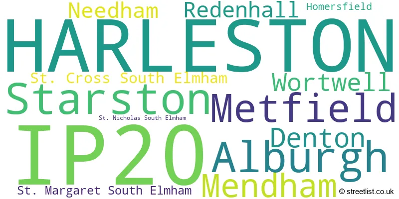
The largest settlement in the IP20 postal code is HARLESTON followed by Alburgh, and Metfield.
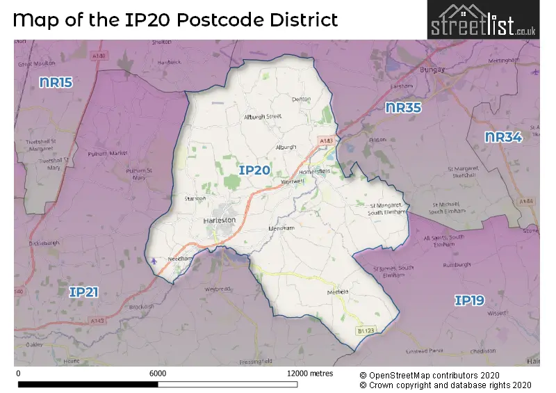
The IP20 Postcode shares a border with IP19 (HALESWORTH, Wenhaston, Holton), IP21 (Stradbroke, Fressingfield, Scole), NR35 (BUNGAY, Ditchingham, Earsham) and NR15 (Long Stratton, Brooke, Hempnall).
In the IP20 postcode district, the primary settlement with the highest count is Harleston. Other significant settlements in the district include Alburgh, Denton, Homersfield, Mendham, Metfield, St. Cross South Elmham, St. Margaret South Elmham, St. Nicholas South Elmham, Wortwell, Needham, Redenhall, and Starston. Harleston is located in Norfolk, Suffolk, and the most significant post town in the district is Harleston.
For the district IP20, we have data on 2 postcode sectors. Here's a breakdown: The sector IP20 0, covers Alburgh and Denton and Wortwell in Norfolk. The sector IP20 0, covers Mendham and Metfield in Suffolk. The sector IP20 9, covers Harleston and Starston in Norfolk.

Map of the IP20 Postcode District
Explore the IP20 postcode district by using our free interactive map.
When it comes to local government, postal geography often disregards political borders. However, for a breakdown in the IP20 District: the district mostly encompasses the South Norfolk District (250 postcodes), followed by the Mid Suffolk District area (45 postcodes), and finally, the East Suffolk District area (20 postcodes).
Recent House Sales in IP20
| Date | Price | Address |
|---|---|---|
| 06/10/2023 | £575,000 | Withersdale Street, Mendham, Harleston, IP20 0JG |
| 14/09/2023 | £650,000 | Trunch Hill, Denton, Harleston, IP20 0AN |
| 11/09/2023 | £315,000 | Market Place, Harleston, IP20 9AD |
| 01/09/2023 | £123,000 | Holly Court, Harleston, IP20 9EJ |
| 30/08/2023 | £230,000 | High Road, Wortwell, Harleston, IP20 0HG |
| 18/08/2023 | £90,000 | Mendham Lane, Harleston, IP20 9DE |
| 18/08/2023 | £115,000 | Malthouse Court, Harleston, IP20 9BU |
| 16/08/2023 | £375,000 | St Margaret South Elmham, Harleston, IP20 0PL |
| 11/08/2023 | £482,500 | Skinners Lane, Metfield, Harleston, IP20 0LH |
| 08/08/2023 | £170,000 | Trunch Hill, Denton, Harleston, IP20 0AN |
Weather Forecast for IP20
Press Button to Show Forecast for Harleston
| Time Period | Icon | Description | Temperature | Rain Probability | Wind |
|---|---|---|---|---|---|
| 12:00 to 15:00 | Light rain shower (day) | 9.0°C (feels like 6.0°C) | 54.00% | NNW 16 mph | |
| 15:00 to 18:00 | Sunny day | 10.0°C (feels like 6.0°C) | 1.00% | NNW 20 mph | |
| 18:00 to 21:00 | Partly cloudy (day) | 7.0°C (feels like 3.0°C) | 2.00% | NNW 18 mph | |
| 21:00 to 00:00 | Cloudy | 5.0°C (feels like 1.0°C) | 5.00% | NNW 13 mph |
Press Button to Show Forecast for Harleston
| Time Period | Icon | Description | Temperature | Rain Probability | Wind |
|---|---|---|---|---|---|
| 00:00 to 03:00 | Clear night | 5.0°C (feels like 1.0°C) | 2.00% | NNW 11 mph | |
| 03:00 to 06:00 | Cloudy | 4.0°C (feels like 1.0°C) | 4.00% | NNW 11 mph | |
| 06:00 to 09:00 | Overcast | 5.0°C (feels like 2.0°C) | 8.00% | NNW 11 mph | |
| 09:00 to 12:00 | Overcast | 8.0°C (feels like 4.0°C) | 9.00% | NNW 16 mph | |
| 12:00 to 15:00 | Overcast | 8.0°C (feels like 5.0°C) | 8.00% | N 16 mph | |
| 15:00 to 18:00 | Cloudy | 8.0°C (feels like 5.0°C) | 4.00% | N 16 mph | |
| 18:00 to 21:00 | Cloudy | 7.0°C (feels like 4.0°C) | 8.00% | N 11 mph | |
| 21:00 to 00:00 | Cloudy | 5.0°C (feels like 3.0°C) | 4.00% | NNW 7 mph |
Press Button to Show Forecast for Harleston
| Time Period | Icon | Description | Temperature | Rain Probability | Wind |
|---|---|---|---|---|---|
| 00:00 to 03:00 | Overcast | 5.0°C (feels like 2.0°C) | 7.00% | NNW 7 mph | |
| 03:00 to 06:00 | Overcast | 5.0°C (feels like 2.0°C) | 8.00% | NNW 9 mph | |
| 06:00 to 09:00 | Overcast | 5.0°C (feels like 2.0°C) | 9.00% | N 9 mph | |
| 09:00 to 12:00 | Overcast | 8.0°C (feels like 4.0°C) | 10.00% | N 13 mph | |
| 12:00 to 15:00 | Overcast | 9.0°C (feels like 7.0°C) | 9.00% | NNE 13 mph | |
| 15:00 to 18:00 | Overcast | 9.0°C (feels like 6.0°C) | 10.00% | NNE 13 mph | |
| 18:00 to 21:00 | Partly cloudy (day) | 8.0°C (feels like 5.0°C) | 2.00% | NNE 9 mph | |
| 21:00 to 00:00 | Cloudy | 5.0°C (feels like 3.0°C) | 5.00% | N 7 mph |
Press Button to Show Forecast for Harleston
| Time Period | Icon | Description | Temperature | Rain Probability | Wind |
|---|---|---|---|---|---|
| 00:00 to 03:00 | Clear night | 4.0°C (feels like 2.0°C) | 1.00% | N 7 mph | |
| 03:00 to 06:00 | Partly cloudy (night) | 3.0°C (feels like 1.0°C) | 2.00% | N 7 mph | |
| 06:00 to 09:00 | Cloudy | 5.0°C (feels like 3.0°C) | 5.00% | N 7 mph | |
| 09:00 to 12:00 | Overcast | 8.0°C (feels like 6.0°C) | 9.00% | N 9 mph | |
| 12:00 to 15:00 | Overcast | 9.0°C (feels like 7.0°C) | 13.00% | N 9 mph | |
| 15:00 to 18:00 | Cloudy | 9.0°C (feels like 6.0°C) | 15.00% | N 9 mph | |
| 18:00 to 21:00 | Light rain | 7.0°C (feels like 5.0°C) | 42.00% | NNE 7 mph | |
| 21:00 to 00:00 | Light rain | 5.0°C (feels like 3.0°C) | 41.00% | NNE 4 mph |
Press Button to Show Forecast for Harleston
| Time Period | Icon | Description | Temperature | Rain Probability | Wind |
|---|---|---|---|---|---|
| 00:00 to 03:00 | Cloudy | 4.0°C (feels like 2.0°C) | 11.00% | WNW 4 mph | |
| 03:00 to 06:00 | Cloudy | 4.0°C (feels like 2.0°C) | 11.00% | WNW 4 mph | |
| 06:00 to 09:00 | Overcast | 5.0°C (feels like 3.0°C) | 15.00% | WNW 4 mph | |
| 09:00 to 12:00 | Overcast | 8.0°C (feels like 6.0°C) | 14.00% | N 7 mph | |
| 12:00 to 15:00 | Overcast | 9.0°C (feels like 7.0°C) | 12.00% | NNE 9 mph | |
| 15:00 to 18:00 | Cloudy | 9.0°C (feels like 7.0°C) | 9.00% | NNE 9 mph | |
| 18:00 to 21:00 | Overcast | 8.0°C (feels like 6.0°C) | 10.00% | NNE 9 mph | |
| 21:00 to 00:00 | Partly cloudy (night) | 6.0°C (feels like 4.0°C) | 2.00% | N 7 mph |
Where is the IP20 Postcode District?
The data indicates that the postcode district IP20 is located in Harleston. Harleston is situated in close proximity to several nearby towns. To the North East is Bungay, which is approximately 4.98 miles away. Halesworth is located to the South East and is about 8.53 miles away. In the West, there is Diss, which is roughly 9.33 miles from Harleston. Eye lies to the South West, with a distance of around 10.03 miles. Beccles is positioned to the East, at a distance of 10.44 miles. Norwich is located to the North and is around 14.37 miles away. Wymondham is situated in the North West, around 15 miles from Harleston. Additionally, it is worth noting that the distance from Harleston to the center of London is approximately 88.34 miles.
The district is within the post town of HARLESTON.
The sector has postcodes within the nation of England.
The IP20 Postcode District is covers the following regions.
- Breckland and South Norfolk - East Anglia - East of England
- Suffolk - East Anglia - East of England
| Postcode Sector | Delivery Office |
|---|---|
| IP20 0 | Harleston Scale Payment Delivery Office |
| IP20 9 | Harleston Scale Payment Delivery Office |
| I | P | 2 | 0 | - | X | X | X |
| I | P | 2 | 0 | Space | Numeric | Letter | Letter |
Current Monthly Rental Prices
| # Bedrooms | Min Price | Max Price | Avg Price |
|---|---|---|---|
| 2 | £1,500 | £1,500 | £1,500 |
| 5 | £995 | £5,000 | £2,998 |
Current House Prices
| # Bedrooms | Min Price | Max Price | Avg Price |
|---|---|---|---|
| £125,000 | £125,000 | £125,000 | |
| 2 | £14,000 | £450,000 | £153,170 |
| 3 | £155,000 | £635,000 | £322,083 |
| 4 | £325,000 | £850,000 | £521,450 |
| 5 | £350,000 | £1,050,000 | £675,000 |
| 6 | £695,000 | £1,500,000 | £955,000 |
| 7 | £1,000,000 | £1,000,000 | £1,000,000 |
Estate Agents who Operate in the IP20 District
| Logo | Name | Brand Name | Address | Contact Number | Total Properties |
|---|---|---|---|---|---|
 | Harleston | Musker McIntyre | 5 London Road, Harleston, Norfolk, IP20 9BH | 01379 777360 | 19 |
 | Harleston | Durrants | 32-34 The Thoroughfare, Harleston, IP20 9AU | 01379 777097 | 13 |
 | Lytham | Sell My Group | The Old Bakery Green Street, Lytham, Lytham St. Annes, FY8 5LG | 020 3910 6164 | 11 |
 | Diss | Parson Estate Agents | Caxton House Victoria Road Diss IP22 4JN | 01379 646180 | 11 |
 | Bungay | Starkings & Watson | 57a Earsham Street, Bungay, NR35 1AF | 01986 490590 | 9 |
| Type of Property | 2018 Average | 2018 Sales | 2017 Average | 2017 Sales | 2016 Average | 2016 Sales | 2015 Average | 2015 Sales |
|---|---|---|---|---|---|---|---|---|
| Detached | £346,985 | 69 | £349,933 | 78 | £276,547 | 101 | £276,677 | 77 |
| Semi-Detached | £213,091 | 33 | £206,632 | 45 | £189,198 | 55 | £173,102 | 64 |
| Terraced | £174,061 | 33 | £169,688 | 21 | £170,397 | 32 | £168,240 | 24 |
| Flats | £110,833 | 3 | £93,795 | 10 | £93,833 | 9 | £91,723 | 11 |
Hotels within the Postcode Area
We found 9 hotels and guest houses within the IP20 postcode area
The Duke William Bed and Breakfast
The Duke William, The Street, Metfield, Harleston, harleston, IP20 0LB.
View details