The IP27 postcode district is a postal district located in the IP Ipswich postcode area with a population of 20,511 residents according to the 2021 England and Wales Census.
The area of the IP27 postcode district is 62.32 square miles which is 161.40 square kilometres or 39,882.37 acres.
Currently, the IP27 district has about 499 postcode units spread across 2 geographic postcode sectors.
Given that each sector allows for 400 unique postcode combinations, the district has a capacity of 800 postcodes. With 499 postcodes already in use, this leaves 301 units available.
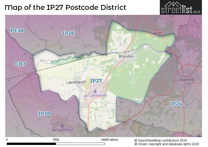
The largest settlement in the IP27 postal code is BRANDON followed by Lakenheath, and RAF Lakenheath.
The IP27 Postcode shares a border with IP26 (Feltwell, Mundford, Hockwold), IP28 (Mildenhall, Red Lodge, Beck Row) and IP24 (THETFORD, Great Hockham, Elveden).
In the IP27 postcode district, the primary settlement is BRANDON in Suffolk. Other significant settlements in the district include Santon Downham, Wangford, Weeting, Eriswell, Lakenheath, Little Eriswell, and RAF Lakenheath. The county of Norfolk also falls within this postcode district. The main postal town in this district is BRANDON.
For the district IP27, we have data on 3 postcode sectors. Here's a breakdown: The sector IP27 0, covers Brandon in Suffolk. The sector IP27 0, covers Weeting in Norfolk. The sector IP27 1 is non-geographic. It's often designated for PO Boxes, large organisations, or special services. The sector IP27 9, covers Lakenheath and Raf Lakenheath in Suffolk.


Map of the IP27 Postcode District
Explore the IP27 postcode district by using our free interactive map.
When it comes to local government, postal geography often disregards political borders. However, for a breakdown in the IP27 District: the district mostly encompasses the West Suffolk District (452 postcodes), and finally, the Breckland District area (56 postcodes).
Recent House Sales in IP27
| Date | Price | Address |
|---|---|---|
| 26/10/2023 | £160,000 | The Orchard, Brandon, IP27 0HR |
| 12/10/2023 | £85,000 | The Maltings, Brandon, IP27 0BL |
| 12/10/2023 | £162,000 | High Street, Lakenheath, Brandon, IP27 9DS |
| 22/09/2023 | £345,000 | Hallmark Close, Lakenheath, Brandon, IP27 9LX |
| 18/09/2023 | £160,000 | The Orchard, Brandon, IP27 0HR |
| 08/09/2023 | £223,500 | Queens Road, Brandon, IP27 0JL |
| 08/09/2023 | £700,000 | Chalk Road, Brandon, IP27 0SD |
| 08/09/2023 | £215,000 | Chestnut Way, Raf Lakenheath, Brandon, IP27 9RD |
| 07/09/2023 | £270,000 | London Road, Brandon, IP27 0EL |
| 05/09/2023 | £170,000 | Willow Close, Brandon, IP27 0UJ |
Weather Forecast for IP27
Press Button to Show Forecast for Thetford Forest Park
| Time Period | Icon | Description | Temperature | Rain Probability | Wind |
|---|---|---|---|---|---|
| 09:00 to 12:00 | Cloudy | 10.0°C (feels like 7.0°C) | 53.00% | NW 16 mph | |
| 12:00 to 15:00 | Light rain shower (day) | 10.0°C (feels like 7.0°C) | 35.00% | NNW 13 mph | |
| 15:00 to 18:00 | Cloudy | 9.0°C (feels like 5.0°C) | 11.00% | N 16 mph | |
| 18:00 to 21:00 | Cloudy | 7.0°C (feels like 4.0°C) | 4.00% | N 16 mph | |
| 21:00 to 00:00 | Partly cloudy (night) | 5.0°C (feels like 2.0°C) | 2.00% | NNW 11 mph |
Press Button to Show Forecast for Thetford Forest Park
| Time Period | Icon | Description | Temperature | Rain Probability | Wind |
|---|---|---|---|---|---|
| 00:00 to 03:00 | Overcast | 5.0°C (feels like 1.0°C) | 8.00% | NNW 11 mph | |
| 03:00 to 06:00 | Overcast | 5.0°C (feels like 1.0°C) | 9.00% | NNW 11 mph | |
| 06:00 to 09:00 | Overcast | 5.0°C (feels like 2.0°C) | 11.00% | NNW 9 mph | |
| 09:00 to 12:00 | Overcast | 7.0°C (feels like 3.0°C) | 9.00% | N 13 mph | |
| 12:00 to 15:00 | Overcast | 9.0°C (feels like 5.0°C) | 10.00% | N 13 mph | |
| 15:00 to 18:00 | Overcast | 9.0°C (feels like 6.0°C) | 8.00% | N 13 mph | |
| 18:00 to 21:00 | Cloudy | 7.0°C (feels like 4.0°C) | 4.00% | N 9 mph | |
| 21:00 to 00:00 | Cloudy | 5.0°C (feels like 3.0°C) | 5.00% | N 7 mph |
Press Button to Show Forecast for Thetford Forest Park
| Time Period | Icon | Description | Temperature | Rain Probability | Wind |
|---|---|---|---|---|---|
| 00:00 to 03:00 | Overcast | 5.0°C (feels like 3.0°C) | 8.00% | NNW 4 mph | |
| 03:00 to 06:00 | Overcast | 5.0°C (feels like 3.0°C) | 8.00% | NNW 4 mph | |
| 06:00 to 09:00 | Overcast | 5.0°C (feels like 3.0°C) | 12.00% | N 7 mph | |
| 09:00 to 12:00 | Overcast | 8.0°C (feels like 5.0°C) | 13.00% | N 9 mph | |
| 12:00 to 15:00 | Overcast | 9.0°C (feels like 7.0°C) | 11.00% | NNE 11 mph | |
| 15:00 to 18:00 | Overcast | 9.0°C (feels like 7.0°C) | 10.00% | NNE 11 mph | |
| 18:00 to 21:00 | Cloudy | 8.0°C (feels like 5.0°C) | 6.00% | NNE 9 mph | |
| 21:00 to 00:00 | Partly cloudy (night) | 6.0°C (feels like 3.0°C) | 4.00% | NNE 7 mph |
Press Button to Show Forecast for Thetford Forest Park
| Time Period | Icon | Description | Temperature | Rain Probability | Wind |
|---|---|---|---|---|---|
| 00:00 to 03:00 | Partly cloudy (night) | 5.0°C (feels like 3.0°C) | 3.00% | NNE 7 mph | |
| 03:00 to 06:00 | Partly cloudy (night) | 5.0°C (feels like 2.0°C) | 2.00% | N 7 mph | |
| 06:00 to 09:00 | Partly cloudy (day) | 5.0°C (feels like 3.0°C) | 3.00% | N 7 mph | |
| 09:00 to 12:00 | Cloudy | 9.0°C (feels like 6.0°C) | 8.00% | NNE 9 mph | |
| 12:00 to 15:00 | Cloudy | 10.0°C (feels like 7.0°C) | 11.00% | NNE 11 mph | |
| 15:00 to 18:00 | Cloudy | 10.0°C (feels like 7.0°C) | 12.00% | NE 11 mph | |
| 18:00 to 21:00 | Overcast | 8.0°C (feels like 6.0°C) | 10.00% | NNE 9 mph | |
| 21:00 to 00:00 | Partly cloudy (night) | 6.0°C (feels like 4.0°C) | 2.00% | NNE 7 mph |
Where is the IP27 Postcode District?
The data suggests that the postcode district IP27 is located in Brandon. Brandon is a district town in the vicinity of several nearby towns. To the east is Thetford, located approximately 6.83 miles away. In the southeast is Bury St. Edmunds, situated approximately 13.92 miles away. To the west is Ely, located around 14.66 miles away. In the northwest is Downham Market, approximately 14.91 miles away. To the north is Swaffham, situated around 15.68 miles away. Lastly, to the south is Newmarket, approximately 15.82 miles away. Additionally, the distance from the IP27 postcode district to the center of London is approximately 70.39 miles.
The district is within the post town of BRANDON.
The sector has postcodes within the nation of England.
The IP27 Postcode District is covers the following regions.
- Breckland and South Norfolk - East Anglia - East of England
- North and West Norfolk - East Anglia - East of England
| Postcode Sector | Delivery Office |
|---|---|
| IP27 0 | Brandon Delivery Office |
| IP27 9 | Brandon Delivery Office |
| IP27 9 | Lakenheath Scale Payment Delivery Office |
| I | P | 2 | 7 | - | X | X | X |
| I | P | 2 | 7 | Space | Numeric | Letter | Letter |
Tourist Attractions within the Postcode Area
We found 3 visitor attractions within the IP27 postcode area
| High Lodge Forest Centre |
|---|
| Country Parks |
| Country Park |
| View High Lodge Forest Centre on Google Maps |
| Grimes Graves |
| Historic Properties |
| Historic Monument / Archaeological Site |
| View Grimes Graves on Google Maps |
| Go Ape! Tree Top Adventure - Thetford |
| Country Parks |
| Country Park |
| View Go Ape! Tree Top Adventure - Thetford on Google Maps |
Current Monthly Rental Prices
| # Bedrooms | Min Price | Max Price | Avg Price |
|---|---|---|---|
| 1 | £850 | £850 | £850 |
| 2 | £1,000 | £1,330 | £1,188 |
| 3 | £1,100 | £1,650 | £1,313 |
| 4 | £1,330 | £2,600 | £1,778 |
| 5 | £2,700 | £2,950 | £2,825 |
| 6 | £1,250 | £1,250 | £1,250 |
Current House Prices
| # Bedrooms | Min Price | Max Price | Avg Price |
|---|---|---|---|
| £150,000 | £2,200,000 | £881,250 | |
| 1 | £140,000 | £190,000 | £173,333 |
| 2 | £100,000 | £290,000 | £194,274 |
| 3 | £180,000 | £500,000 | £269,848 |
| 4 | £245,000 | £795,000 | £424,615 |
| 5 | £240,000 | £750,000 | £545,833 |
Estate Agents who Operate in the IP27 District
| Logo | Name | Brand Name | Address | Contact Number | Total Properties |
|---|---|---|---|---|---|
 | Brandon | William H. Brown | 20 High Street, Brandon, IP27 0AQ | 01842 771037 | 27 |
 | Mildenhall | Balmforth | 22-26 High Street, Mildenhall, IP28 7EQ | 01638 597109 | 26 |
 | Brandon | Molyneux Estate Agents | 49a High Street, Brandon, IP27 0AQ | 01842 771033 | 23 |
 | Brandon | William H. Brown | 20 High Street, Brandon, IP27 0AQ | 01842 773656 | 21 |
 | Mildenhall | Henleys | 16 High Street Mildenhall IP28 7EQ | 01638 597091 | 14 |
| Type of Property | 2018 Average | 2018 Sales | 2017 Average | 2017 Sales | 2016 Average | 2016 Sales | 2015 Average | 2015 Sales |
|---|---|---|---|---|---|---|---|---|
| Detached | £223,286 | 154 | £223,560 | 162 | £212,010 | 179 | £187,122 | 181 |
| Semi-Detached | £177,276 | 97 | £170,042 | 90 | £150,424 | 85 | £143,511 | 105 |
| Terraced | £176,003 | 217 | £164,320 | 201 | £139,438 | 130 | £122,653 | 157 |
| Flats | £98,000 | 10 | £84,886 | 14 | £76,958 | 24 | £80,486 | 7 |
Hotels within the Postcode Area
We found 6 hotels and guest houses within the IP27 postcode area