The IP29 postcode district is a postal district located in the IP Ipswich postcode area with a population of 9,170 residents according to the 2021 England and Wales Census.
The area of the IP29 postcode district is 59.06 square miles which is 152.98 square kilometres or 37,800.93 acres.
Currently, the IP29 district has about 404 postcode units spread across 2 geographic postcode sectors.
Given that each sector allows for 400 unique postcode combinations, the district has a capacity of 800 postcodes. With 404 postcodes already in use, this leaves 396 units available.
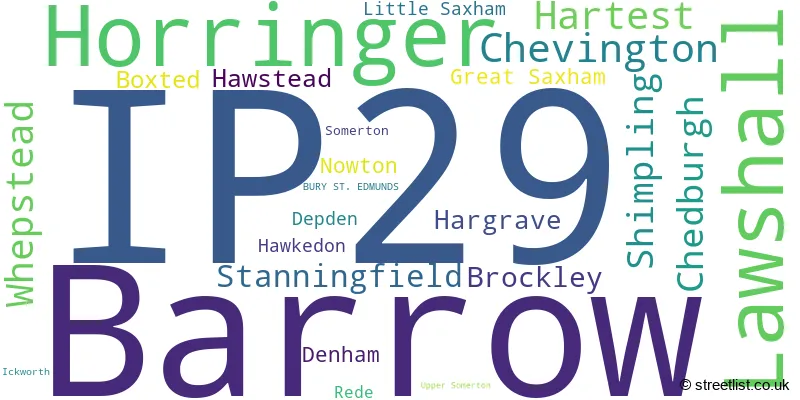
The largest settlement in the IP29 postal code is Barrow followed by Lawshall, and Horringer.
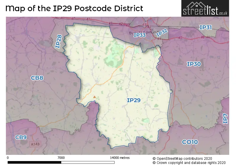
The IP29 Postcode shares a border with IP28 (Mildenhall, Red Lodge, Beck Row), IP30 (Elmswell, Woolpit, Cockfield), IP33 (BURY ST. EDMUNDS), CB8 (NEWMARKET, Exning, Wickhambrook) and CO10 (SUDBURY, Great Cornard, Long Melford).
The primary settlement in the IP29 postcode district is Lawshall, located in Bury St. Edmunds, Suffolk. Other significant settlements in the district include Boxted, Brockley, Chedburgh, Depden, Hartest, Hawkedon, Horringer, Rede, Shimpling, Somerton, Stanningfield, Upper Somerton, and Whepstead.
For the district IP29, we have data on 2 postcode sectors. Here's a breakdown: The sector IP29 4, covers Lawshall and Hartest and Whepstead and Chedburgh and Shimpling and Stanningfield in Suffolk. The sector IP29 5, covers Barrow and Horringer and Chevington in Suffolk.

Map of the IP29 Postcode District
Explore the IP29 postcode district by using our free interactive map.
When it comes to local government, postal geography often disregards political borders. However, for a breakdown in the IP29 District: the district mostly encompasses the West Suffolk District (298 postcodes), and finally, the Babergh District area (109 postcodes).
Recent House Sales in IP29
| Date | Price | Address |
|---|---|---|
| 17/10/2023 | £474,995 | Birdbrook, Brockley, Bury St Edmunds, IP29 4AA |
| 04/10/2023 | £525,000 | Hargrave, Bury St Edmunds, IP29 5HX |
| 15/09/2023 | £425,000 | The Row, Boxted, Bury St Edmunds, IP29 4JY |
| 31/08/2023 | £690,000 | Hargrave Road, Chevington, Bury St Edmunds, IP29 5QR |
| 30/08/2023 | £275,000 | The Glebe, Lawshall, Bury St Edmunds, IP29 4PW |
| 30/08/2023 | £370,000 | Swanfield, Lawshall, Bury St Edmunds, IP29 4QB |
| 14/08/2023 | £322,500 | Hazel Drive, Horringer, Bury St Edmunds, IP29 5ST |
| 01/08/2023 | £2,400,000 | Little Saxham, Bury St Edmunds, IP29 5LH |
| 26/07/2023 | £635,000 | Beale Road, Barrow, Bury St Edmunds, IP29 5ES |
| 12/07/2023 | £285,000 | The Street, Horringer, Bury St Edmunds, IP29 5SN |
Weather Forecast for IP29
Press Button to Show Forecast for Rede
| Time Period | Icon | Description | Temperature | Rain Probability | Wind |
|---|---|---|---|---|---|
| 03:00 to 06:00 | Cloudy | 4.0°C (feels like 1.0°C) | 5.00% | SW 7 mph | |
| 06:00 to 09:00 | Cloudy | 5.0°C (feels like 2.0°C) | 13.00% | WSW 9 mph | |
| 09:00 to 12:00 | Cloudy | 8.0°C (feels like 5.0°C) | 9.00% | W 11 mph | |
| 12:00 to 15:00 | Cloudy | 8.0°C (feels like 5.0°C) | 39.00% | W 11 mph | |
| 15:00 to 18:00 | Cloudy | 6.0°C (feels like 3.0°C) | 15.00% | N 9 mph | |
| 18:00 to 21:00 | Cloudy | 6.0°C (feels like 4.0°C) | 10.00% | NNE 4 mph | |
| 21:00 to 00:00 | Partly cloudy (night) | 3.0°C (feels like 1.0°C) | 1.00% | NNE 4 mph |
Press Button to Show Forecast for Rede
| Time Period | Icon | Description | Temperature | Rain Probability | Wind |
|---|---|---|---|---|---|
| 00:00 to 03:00 | Clear night | 0.0°C (feels like -2.0°C) | 0.00% | N 4 mph | |
| 03:00 to 06:00 | Clear night | -1.0°C (feels like -4.0°C) | 0.00% | NNW 4 mph | |
| 06:00 to 09:00 | Sunny day | 2.0°C (feels like -1.0°C) | 1.00% | NNW 4 mph | |
| 09:00 to 12:00 | Cloudy | 7.0°C (feels like 5.0°C) | 4.00% | NE 7 mph | |
| 12:00 to 15:00 | Cloudy | 9.0°C (feels like 8.0°C) | 6.00% | NE 4 mph | |
| 15:00 to 18:00 | Overcast | 9.0°C (feels like 8.0°C) | 10.00% | ENE 4 mph | |
| 18:00 to 21:00 | Cloudy | 8.0°C (feels like 6.0°C) | 8.00% | E 7 mph | |
| 21:00 to 00:00 | Cloudy | 4.0°C (feels like 2.0°C) | 9.00% | E 7 mph |
Press Button to Show Forecast for Rede
| Time Period | Icon | Description | Temperature | Rain Probability | Wind |
|---|---|---|---|---|---|
| 00:00 to 03:00 | Partly cloudy (night) | 3.0°C (feels like 0.0°C) | 7.00% | ENE 7 mph | |
| 03:00 to 06:00 | Cloudy | 2.0°C (feels like -1.0°C) | 13.00% | NE 7 mph | |
| 06:00 to 09:00 | Cloudy | 4.0°C (feels like 1.0°C) | 16.00% | ENE 9 mph | |
| 09:00 to 12:00 | Cloudy | 9.0°C (feels like 6.0°C) | 17.00% | ENE 9 mph | |
| 12:00 to 15:00 | Cloudy | 11.0°C (feels like 9.0°C) | 15.00% | E 9 mph | |
| 15:00 to 18:00 | Overcast | 11.0°C (feels like 9.0°C) | 19.00% | E 11 mph | |
| 18:00 to 21:00 | Cloudy | 10.0°C (feels like 7.0°C) | 17.00% | ENE 11 mph | |
| 21:00 to 00:00 | Overcast | 8.0°C (feels like 5.0°C) | 20.00% | NE 11 mph |
Press Button to Show Forecast for Rede
| Time Period | Icon | Description | Temperature | Rain Probability | Wind |
|---|---|---|---|---|---|
| 00:00 to 03:00 | Light rain | 8.0°C (feels like 5.0°C) | 48.00% | ENE 11 mph | |
| 03:00 to 06:00 | Heavy rain | 9.0°C (feels like 6.0°C) | 74.00% | ESE 11 mph | |
| 06:00 to 09:00 | Light rain | 9.0°C (feels like 7.0°C) | 52.00% | SE 11 mph | |
| 09:00 to 12:00 | Light rain shower (day) | 11.0°C (feels like 8.0°C) | 44.00% | SSE 13 mph | |
| 12:00 to 15:00 | Heavy rain shower (day) | 11.0°C (feels like 9.0°C) | 61.00% | S 13 mph | |
| 15:00 to 18:00 | Light rain shower (day) | 12.0°C (feels like 10.0°C) | 44.00% | SW 13 mph | |
| 18:00 to 21:00 | Light rain shower (day) | 11.0°C (feels like 9.0°C) | 34.00% | SW 11 mph | |
| 21:00 to 00:00 | Partly cloudy (night) | 8.0°C (feels like 6.0°C) | 6.00% | WSW 9 mph |
Where is the IP29 Postcode District?
The IP29 postcode district is located in Bury St. Edmunds. Bury St. Edmunds is situated near several other towns, including Newmarket to the west (9.82 miles away), Sudbury to the south (10.43 miles away), Haverhill to the southwest (12.17 miles away), Stowmarket to the east (13.67 miles away), and Thetford to the north (17.04 miles away). Bury St. Edmunds is also approximately 57.77 miles away from the center of London.
The district is within the post town of BURY ST. EDMUNDS.
The sector has postcodes within the nation of England.
The IP29 Postcode District is in the Suffolk region of East Anglia within the East of England.
| Postcode Sector | Delivery Office |
|---|---|
| IP29 4 | Whepstead Scale Payment Delivery Office |
| IP29 4 | Bury St. Edmunds Delivery Office |
| IP29 5 | Bury St. Edmunds Delivery Office |
| I | P | 2 | 9 | - | X | X | X |
| I | P | 2 | 9 | Space | Numeric | Letter | Letter |
Tourist Attractions within the Postcode Area
We found 1 visitor attractions within the IP29 postcode area
| Ickworth House, Park and Gardens |
|---|
| Historic Properties |
| Historic House / House and Garden / Palace |
| View Ickworth House, Park and Gardens on Google Maps |
Current Monthly Rental Prices
| # Bedrooms | Min Price | Max Price | Avg Price |
|---|---|---|---|
| £1,250 | £1,250 | £1,250 | |
| 2 | £1,050 | £1,800 | £1,550 |
| 4 | £1,550 | £1,550 | £1,550 |
Current House Prices
| # Bedrooms | Min Price | Max Price | Avg Price |
|---|---|---|---|
| £130,000 | £1,100,000 | £453,333 | |
| 2 | £260,000 | £479,995 | £358,333 |
| 3 | £230,000 | £750,000 | £427,000 |
| 4 | £425,000 | £1,200,000 | £693,375 |
| 5 | £675,000 | £1,350,000 | £953,999 |
| 6 | £1,000,000 | £6,100,000 | £2,816,667 |
| 8 | £6,100,000 | £6,100,000 | £6,100,000 |
Estate Agents who Operate in the IP29 District
| Logo | Name | Brand Name | Address | Contact Number | Total Properties |
|---|---|---|---|---|---|
 | Bury St. Edmunds | David Burr Estate Agents | Abbey House Angel Hill, Bury St. Edmunds, IP33 1LS | 01284 658150 | 8 |
 | Long Melford | David Burr Estate Agents | Walnut Tree House Hall Street, Long Melford, CO10 9JG | 01787 322152 | 7 |
 | Bury St Edmunds | Sheridans | 19 Langton Place, Bury St Edmunds, IP33 1NE | 01284 333376 | 6 |
 | Bury St Edmunds | Jackson-Stops | 11 Guildhall Street Bury St. Edmunds IP33 1PR | 01284 333388 | 4 |
 | Bury St Edmunds | Mark Ewin | 77 St. Johns Street, Bury St. Edmunds, IP33 1SQ | 01284 336099 | 4 |
- Barrow
- Boxted
- Broad Green
- Brockley
- Burthorpe
- Bury St Edmunds
- Chedburgh
- Chevington
- Clopton Green
- Cross Green
- Denham
- Denham End
- Depden
- Glemsford
- Great Saxham
- Great Welnetham
- Hanningfield Green
- Hargrave
- Hartest
- Hawkedon
- Hawstead Green
- Hoggard's Green
- Horringer
- Lawshall
- Lower Street
- Melon Green
- Mickley Green
- Pinford End
- Pound Green
- Rede
- Risby
- Shimpling
- Shimpling Street
- Sicklesmere
- Stanningfield
- Stanstead
- Tan Office Green
- Westley
- Whepstead
| Type of Property | 2018 Average | 2018 Sales | 2017 Average | 2017 Sales | 2016 Average | 2016 Sales | 2015 Average | 2015 Sales |
|---|---|---|---|---|---|---|---|---|
| Detached | £486,732 | 73 | £462,794 | 78 | £407,812 | 92 | £464,478 | 86 |
| Semi-Detached | £348,440 | 21 | £284,408 | 45 | £290,773 | 37 | £278,909 | 36 |
| Terraced | £272,708 | 12 | £252,443 | 23 | £262,033 | 25 | £243,341 | 29 |
| Flats | £185,000 | 1 | £0 | 0 | £270,000 | 1 | £286,666 | 6 |