The L11 postcode district is a postal district located in the L Liverpool postcode area with a population of 29,577 residents according to the 2021 England and Wales Census.
The area of the L11 postcode district is 2.38 square miles which is 6.18 square kilometres or 1,526.29 acres.
Currently, the L11 district has about 543 postcode units spread across 10 geographic postcode sectors.
Given that each sector allows for 400 unique postcode combinations, the district has a capacity of 4,000 postcodes. With 543 postcodes already in use, this leaves 3457 units available.
The largest settlement in the L11 postal code is LIVERPOOL followed by Norris Green, and West Derby.
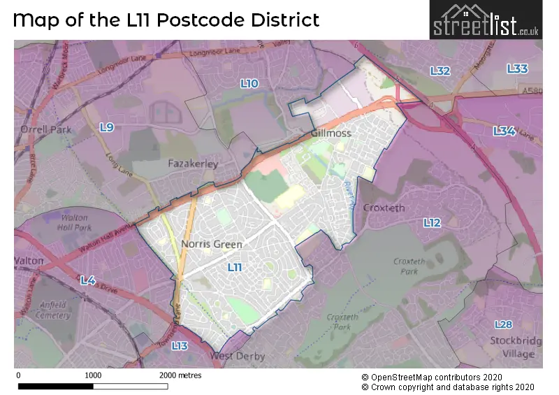
The L11 Postcode shares a border with L10 (LIVERPOOL, Fazakerley, Aintree), L12 (LIVERPOOL, West Derby), L13 (LIVERPOOL, Old Swan, Tuebrook), L4 (LIVERPOOL, Walton, Anfield), L32 (LIVERPOOL, Kirkby) and L9 (LIVERPOOL, Walton, Orrell Park).
In the L11 postcode district, the primary settlement is Liverpool, located in the county of Merseyside within England.
For the district L11, we have data on 10 postcode sectors. Here's a breakdown: The sector L11 0, covers Liverpool in Merseyside. The sector L11 1, covers Liverpool in Merseyside. The sector L11 2, covers Liverpool in Merseyside. The sector L11 3, covers Liverpool in Merseyside. The sector L11 4, covers Liverpool in Merseyside. The sector L11 5, covers Liverpool and Norris Green in Merseyside. The sector L11 6, covers Liverpool and Croxteth in Merseyside. The sector L11 7, covers Liverpool and Norris Green in Merseyside. The sector L11 8, covers Liverpool and Norris Green and West Derby in Merseyside. The sector L11 9, covers Liverpool in Merseyside.

Map of the L11 Postcode District
Explore the L11 postcode district by using our free interactive map.
When it comes to local government, postal geography often disregards political borders. However, for a breakdown in the L11 District: the district mostly encompasses the Liverpool District (B) area with a total of 546 postcodes.
Recent House Sales in L11
| Date | Price | Address |
|---|---|---|
| 21/09/2023 | £108,500 | Lorenzo Drive, Liverpool, L11 1BE |
| 15/09/2023 | £155,000 | Townsend Avenue, Norris Green, Liverpool, L11 8NE |
| 08/09/2023 | £135,000 | Lorenzo Drive, Liverpool, L11 1BQ |
| 07/09/2023 | £115,000 | Prestbury Road, Liverpool, L11 3EA |
| 31/08/2023 | £102,000 | Carr Close, Liverpool, L11 4UA |
| 24/08/2023 | £60,000 | Stockmoor Road, Liverpool, L11 3EG |
| 22/08/2023 | £100,000 | Stonedale Crescent, Liverpool, L11 9BS |
| 21/08/2023 | £144,000 | Muirhead Avenue East, Liverpool, L11 1EH |
| 10/08/2023 | £100,000 | Utting Avenue East, Liverpool, L11 1DH |
| 10/08/2023 | £213,250 | Redruth Road, Liverpool, L11 6NA |
Weather Forecast for L11
Press Button to Show Forecast for Fazakerley
| Time Period | Icon | Description | Temperature | Rain Probability | Wind |
|---|---|---|---|---|---|
| 03:00 to 06:00 | Partly cloudy (night) | 6.0°C (feels like 5.0°C) | 0.00% | ESE 2 mph | |
| 06:00 to 09:00 | Partly cloudy (day) | 6.0°C (feels like 5.0°C) | 1.00% | S 2 mph | |
| 09:00 to 12:00 | Cloudy | 9.0°C (feels like 8.0°C) | 4.00% | W 2 mph | |
| 12:00 to 15:00 | Cloudy | 11.0°C (feels like 10.0°C) | 4.00% | NW 7 mph | |
| 15:00 to 18:00 | Sunny day | 11.0°C (feels like 9.0°C) | 0.00% | NW 9 mph | |
| 18:00 to 21:00 | Cloudy | 10.0°C (feels like 9.0°C) | 3.00% | NNW 7 mph | |
| 21:00 to 00:00 | Partly cloudy (night) | 9.0°C (feels like 8.0°C) | 0.00% | NNW 4 mph |
Press Button to Show Forecast for Fazakerley
| Time Period | Icon | Description | Temperature | Rain Probability | Wind |
|---|---|---|---|---|---|
| 00:00 to 03:00 | Partly cloudy (night) | 8.0°C (feels like 8.0°C) | 0.00% | NNW 4 mph | |
| 03:00 to 06:00 | Cloudy | 8.0°C (feels like 7.0°C) | 4.00% | WSW 4 mph | |
| 06:00 to 09:00 | Cloudy | 8.0°C (feels like 6.0°C) | 13.00% | SSE 4 mph | |
| 09:00 to 12:00 | Overcast | 9.0°C (feels like 8.0°C) | 38.00% | NNE 7 mph | |
| 12:00 to 15:00 | Cloudy | 10.0°C (feels like 9.0°C) | 10.00% | NE 7 mph | |
| 15:00 to 18:00 | Cloudy | 11.0°C (feels like 10.0°C) | 7.00% | NE 7 mph | |
| 18:00 to 21:00 | Cloudy | 11.0°C (feels like 9.0°C) | 7.00% | NE 7 mph | |
| 21:00 to 00:00 | Cloudy | 9.0°C (feels like 8.0°C) | 6.00% | ENE 7 mph |
Press Button to Show Forecast for Fazakerley
| Time Period | Icon | Description | Temperature | Rain Probability | Wind |
|---|---|---|---|---|---|
| 00:00 to 03:00 | Overcast | 8.0°C (feels like 6.0°C) | 11.00% | ESE 7 mph | |
| 03:00 to 06:00 | Overcast | 7.0°C (feels like 6.0°C) | 11.00% | SSE 7 mph | |
| 06:00 to 09:00 | Overcast | 7.0°C (feels like 5.0°C) | 11.00% | S 7 mph | |
| 09:00 to 12:00 | Light rain | 8.0°C (feels like 7.0°C) | 47.00% | S 7 mph | |
| 12:00 to 15:00 | Cloudy | 10.0°C (feels like 8.0°C) | 10.00% | NNE 7 mph | |
| 15:00 to 18:00 | Cloudy | 11.0°C (feels like 9.0°C) | 9.00% | NNE 9 mph | |
| 18:00 to 21:00 | Cloudy | 10.0°C (feels like 9.0°C) | 15.00% | NE 9 mph | |
| 21:00 to 00:00 | Light rain | 10.0°C (feels like 8.0°C) | 49.00% | ENE 7 mph |
Press Button to Show Forecast for Fazakerley
| Time Period | Icon | Description | Temperature | Rain Probability | Wind |
|---|---|---|---|---|---|
| 00:00 to 03:00 | Cloudy | 9.0°C (feels like 8.0°C) | 5.00% | ESE 4 mph | |
| 03:00 to 06:00 | Overcast | 8.0°C (feels like 7.0°C) | 8.00% | ENE 7 mph | |
| 06:00 to 09:00 | Overcast | 8.0°C (feels like 7.0°C) | 8.00% | E 7 mph | |
| 09:00 to 12:00 | Partly cloudy (day) | 10.0°C (feels like 8.0°C) | 3.00% | NNE 7 mph | |
| 12:00 to 15:00 | Cloudy | 11.0°C (feels like 9.0°C) | 5.00% | NE 9 mph | |
| 15:00 to 18:00 | Cloudy | 12.0°C (feels like 9.0°C) | 6.00% | NNW 11 mph | |
| 18:00 to 21:00 | Partly cloudy (day) | 11.0°C (feels like 9.0°C) | 2.00% | NNW 11 mph | |
| 21:00 to 00:00 | Clear night | 9.0°C (feels like 7.0°C) | 1.00% | N 9 mph |
Where is the L11 Postcode District?
The L11 postcode district is located in LIVERPOOL. It is in close proximity to several nearby towns. To the West is BOOTLE, which is approximately 3.15 miles away. To the South East is PRESCOT, which is approximately 5.34 miles away. To the South West is BIRKENHEAD, which is approximately 7.51 miles away. To the East is ST. HELENS, which is approximately 7.57 miles away. To the North is ORMSKIRK, which is approximately 8.79 miles away. To the North East is SKELMERSDALE, which is approximately 8.95 miles away. Additionally, the distance from the L11 postcode district to the centre of London is approximately 178.47 miles.
The district is within the post town of LIVERPOOL.
The sector has postcodes within the nation of England.
The L11 Postcode District is in the Liverpool region of Merseyside within the North West (England).
Postcode Sectors within the L11 District
| Postcode Sector | Delivery Office |
|---|---|
| L11 0 | West Derby Delivery Office |
| L11 1 | West Derby Delivery Office |
| L11 2 | West Derby Delivery Office |
| L11 3 | West Derby Delivery Office |
| L11 4 | West Derby Delivery Office |
| L11 5 | West Derby Delivery Office |
| L11 6 | West Derby Delivery Office |
| L11 7 | West Derby Delivery Office |
| L11 8 | West Derby Delivery Office |
| L11 9 | West Derby Delivery Office |
| L | 1 | 1 | - | X | X | X |
| L | 1 | 1 | Space | Numeric | Letter | Letter |
Current Monthly Rental Prices
| # Bedrooms | Min Price | Max Price | Avg Price |
|---|---|---|---|
| 1 | £550 | £780 | £647 |
| 2 | £695 | £695 | £695 |
| 3 | £795 | £1,400 | £985 |
| 4 | £1,105 | £1,105 | £1,105 |
Current House Prices
| # Bedrooms | Min Price | Max Price | Avg Price |
|---|---|---|---|
| 2 | £27,500 | £155,000 | £84,575 |
| 3 | £37,000 | £280,000 | £164,211 |
| 4 | £249,950 | £325,000 | £289,988 |
Estate Agents who Operate in the L11 District
| Logo | Name | Brand Name | Address | Contact Number | Total Properties |
|---|---|---|---|---|---|
 | Liverpool | Northwood | 15-17 West Derby Village, Liverpool, L12 5HJ | 0151 453 1399 | 7 |
 | West Derby | Sutton Kersh | 18 West Derby Village, West Derby, Liverpool L12 5HW | 0151 453 5147 | 6 |
 | Liverpool | Priory Property Services | 70 Priory Road, Anfield, Liverpool, L4 2RZ | 0151 260 0300 | 6 |
 | Liverpool | Strike | Nationwide | 0151 453 3496 | 6 |
 | West Derby | Keybanks Estates | 11-13 West Derby Village, West Derby, Liverpool, L12 5HJ | 0151 453 8457 | 5 |
| Type of Property | 2018 Average | 2018 Sales | 2017 Average | 2017 Sales | 2016 Average | 2016 Sales | 2015 Average | 2015 Sales |
|---|---|---|---|---|---|---|---|---|
| Detached | £185,945 | 31 | £177,221 | 53 | £169,295 | 33 | £152,748 | 40 |
| Semi-Detached | £124,248 | 146 | £130,266 | 148 | £116,924 | 124 | £105,736 | 123 |
| Terraced | £77,891 | 117 | £75,832 | 138 | £79,087 | 101 | £71,099 | 109 |
| Flats | £77,187 | 8 | £67,190 | 5 | £50,945 | 11 | £91,389 | 9 |