The L12 postcode district is a postal district located in the L Liverpool postcode area with a population of 30,656 residents according to the 2021 England and Wales Census.
The area of the L12 postcode district is 3.97 square miles which is 10.28 square kilometres or 2,540.64 acres.
Currently, the L12 district has about 592 postcode units spread across 10 geographic postcode sectors.
Given that each sector allows for 400 unique postcode combinations, the district has a capacity of 4,000 postcodes. With 592 postcodes already in use, this leaves 3408 units available.
The largest settlements in the L12 postal code are LIVERPOOL and West Derby.
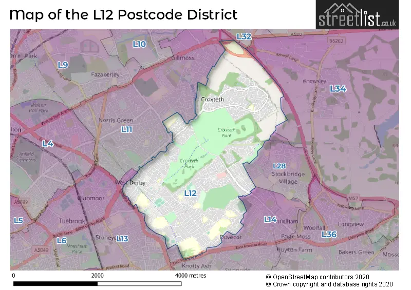
The L12 Postcode shares a border with L11 (LIVERPOOL, Norris Green, West Derby), L13 (LIVERPOOL, Old Swan, Tuebrook), L14 (LIVERPOOL, Knotty Ash, Broadgreen) and L28 (LIVERPOOL, Stockbridge Village).
The primary settlement in the L12 postcode district is Liverpool, located in the county of Merseyside in England. Other significant settlements in this district include West Derby and Sandfield Park.
For the district L12, we have data on 10 postcode sectors. Here's a breakdown: The sector L12 0, covers Liverpool and West Derby in Merseyside. The sector L12 1, covers Liverpool and Sandfield Park and West Derby in Merseyside. The sector L12 2, covers Liverpool and West Derby in Merseyside. The sector L12 3, covers Liverpool and West Derby and Knotty Ash in Merseyside. The sector L12 4, covers Liverpool and West Derby in Merseyside. The sector L12 5, covers Liverpool in Merseyside. The sector L12 6, covers Liverpool in Merseyside. The sector L12 7, covers Liverpool and West Derby in Merseyside. The sector L12 8, covers Liverpool in Merseyside. The sector L12 9, covers Liverpool in Merseyside.

Map of the L12 Postcode District
Explore the L12 postcode district by using our free interactive map.
When it comes to local government, postal geography often disregards political borders. However, for a breakdown in the L12 District: the district mostly encompasses the Liverpool District (B) area with a total of 591 postcodes.
Recent House Sales in L12
| Date | Price | Address |
|---|---|---|
| 13/10/2023 | £185,000 | Bowden Close, Liverpool, L12 0LA |
| 04/10/2023 | £305,000 | Bellefield Avenue, Liverpool, L12 1LR |
| 04/10/2023 | £299,950 | Eaton Gardens, Liverpool, L12 3HN |
| 29/09/2023 | £190,000 | Grange Avenue, West Derby, Liverpool, L12 9JY |
| 25/09/2023 | £177,500 | Grange Avenue, West Derby, Liverpool, L12 9JR |
| 22/09/2023 | £170,000 | Aysgarth Avenue, Liverpool, L12 8QS |
| 11/09/2023 | £177,000 | Burghill Road, Liverpool, L12 0PP |
| 08/09/2023 | £150,000 | Shobdon Close, Liverpool, L12 0PS |
| 31/08/2023 | £85,000 | Yew Tree Lane, West Derby, Liverpool, L12 9HG |
| 29/08/2023 | £220,000 | Craven Road, Liverpool, L12 8RT |
Weather Forecast for L12
Press Button to Show Forecast for Croxteth Hall
| Time Period | Icon | Description | Temperature | Rain Probability | Wind |
|---|---|---|---|---|---|
| 15:00 to 18:00 | Cloudy | 11.0°C (feels like 9.0°C) | 8.00% | NNW 11 mph | |
| 18:00 to 21:00 | Cloudy | 10.0°C (feels like 8.0°C) | 4.00% | NW 11 mph | |
| 21:00 to 00:00 | Overcast | 9.0°C (feels like 7.0°C) | 7.00% | NNW 7 mph |
Press Button to Show Forecast for Croxteth Hall
| Time Period | Icon | Description | Temperature | Rain Probability | Wind |
|---|---|---|---|---|---|
| 00:00 to 03:00 | Cloudy | 9.0°C (feels like 8.0°C) | 6.00% | SSW 4 mph | |
| 03:00 to 06:00 | Cloudy | 7.0°C (feels like 6.0°C) | 3.00% | ENE 4 mph | |
| 06:00 to 09:00 | Sunny day | 6.0°C (feels like 4.0°C) | 0.00% | NNE 7 mph | |
| 09:00 to 12:00 | Sunny day | 7.0°C (feels like 6.0°C) | 0.00% | NNE 7 mph | |
| 12:00 to 15:00 | Partly cloudy (day) | 10.0°C (feels like 8.0°C) | 1.00% | NNW 7 mph | |
| 15:00 to 18:00 | Partly cloudy (day) | 10.0°C (feels like 7.0°C) | 1.00% | NW 11 mph | |
| 18:00 to 21:00 | Sunny day | 9.0°C (feels like 6.0°C) | 0.00% | NW 9 mph | |
| 21:00 to 00:00 | Clear night | 7.0°C (feels like 5.0°C) | 1.00% | NW 7 mph |
Press Button to Show Forecast for Croxteth Hall
| Time Period | Icon | Description | Temperature | Rain Probability | Wind |
|---|---|---|---|---|---|
| 00:00 to 03:00 | Cloudy | 7.0°C (feels like 5.0°C) | 4.00% | WNW 9 mph | |
| 03:00 to 06:00 | Cloudy | 7.0°C (feels like 4.0°C) | 4.00% | WNW 11 mph | |
| 06:00 to 09:00 | Cloudy | 7.0°C (feels like 5.0°C) | 7.00% | NW 11 mph | |
| 09:00 to 12:00 | Partly cloudy (day) | 8.0°C (feels like 5.0°C) | 5.00% | NW 11 mph | |
| 12:00 to 15:00 | Partly cloudy (day) | 9.0°C (feels like 7.0°C) | 4.00% | NW 11 mph | |
| 15:00 to 18:00 | Cloudy | 10.0°C (feels like 7.0°C) | 5.00% | NW 11 mph | |
| 18:00 to 21:00 | Partly cloudy (day) | 9.0°C (feels like 7.0°C) | 2.00% | NW 9 mph | |
| 21:00 to 00:00 | Cloudy | 8.0°C (feels like 6.0°C) | 6.00% | NNE 7 mph |
Press Button to Show Forecast for Croxteth Hall
| Time Period | Icon | Description | Temperature | Rain Probability | Wind |
|---|---|---|---|---|---|
| 00:00 to 03:00 | Cloudy | 7.0°C (feels like 4.0°C) | 8.00% | ESE 7 mph | |
| 03:00 to 06:00 | Cloudy | 6.0°C (feels like 3.0°C) | 9.00% | SE 7 mph | |
| 06:00 to 09:00 | Cloudy | 5.0°C (feels like 3.0°C) | 12.00% | ESE 9 mph | |
| 09:00 to 12:00 | Cloudy | 7.0°C (feels like 5.0°C) | 12.00% | E 9 mph | |
| 12:00 to 15:00 | Overcast | 9.0°C (feels like 7.0°C) | 14.00% | E 9 mph | |
| 15:00 to 18:00 | Overcast | 10.0°C (feels like 8.0°C) | 16.00% | E 7 mph | |
| 18:00 to 21:00 | Overcast | 10.0°C (feels like 8.0°C) | 15.00% | E 7 mph | |
| 21:00 to 00:00 | Overcast | 8.0°C (feels like 6.0°C) | 15.00% | ENE 9 mph |
Press Button to Show Forecast for Croxteth Hall
| Time Period | Icon | Description | Temperature | Rain Probability | Wind |
|---|---|---|---|---|---|
| 00:00 to 03:00 | Cloudy | 7.0°C (feels like 4.0°C) | 12.00% | E 9 mph | |
| 03:00 to 06:00 | Overcast | 6.0°C (feels like 4.0°C) | 18.00% | E 9 mph | |
| 06:00 to 09:00 | Cloudy | 6.0°C (feels like 4.0°C) | 18.00% | E 9 mph | |
| 09:00 to 12:00 | Cloudy | 8.0°C (feels like 6.0°C) | 15.00% | E 9 mph | |
| 12:00 to 15:00 | Overcast | 11.0°C (feels like 8.0°C) | 19.00% | E 11 mph | |
| 15:00 to 18:00 | Cloudy | 11.0°C (feels like 9.0°C) | 41.00% | ENE 11 mph | |
| 18:00 to 21:00 | Cloudy | 10.0°C (feels like 8.0°C) | 13.00% | ENE 11 mph | |
| 21:00 to 00:00 | Cloudy | 9.0°C (feels like 7.0°C) | 14.00% | ENE 11 mph |
Where is the L12 Postcode District?
The data shows that the L12 postcode district is located in Liverpool. It is surrounded by several nearby towns, including Prescot to the east, Bootle to the northwest, Wallasey to the west, Widnes to the southeast, Birkenhead to the southwest, Skelmersdale to the northeast, and Ormskirk to the north. Additionally, the L12 district is approximately 177.28 miles away from the center of London.
The district is within the post town of LIVERPOOL.
The sector has postcodes within the nation of England.
The L12 Postcode District is in the Liverpool region of Merseyside within the North West (England).
Postcode Sectors within the L12 District
| Postcode Sector | Delivery Office |
|---|---|
| L12 0 | West Derby Delivery Office |
| L12 1 | West Derby Delivery Office |
| L12 2 | West Derby Delivery Office |
| L12 3 | West Derby Delivery Office |
| L12 4 | West Derby Delivery Office |
| L12 5 | West Derby Delivery Office |
| L12 6 | West Derby Delivery Office |
| L12 7 | West Derby Delivery Office |
| L12 8 | West Derby Delivery Office |
| L12 9 | West Derby Delivery Office |
| L | 1 | 2 | - | X | X | X |
| L | 1 | 2 | Space | Numeric | Letter | Letter |
Current Monthly Rental Prices
| # Bedrooms | Min Price | Max Price | Avg Price |
|---|---|---|---|
| 2 | £725 | £850 | £788 |
| 3 | £463 | £1,700 | £1,011 |
| 4 | £1,000 | £1,000 | £1,000 |
| 5 | £2,000 | £2,000 | £2,000 |
Current House Prices
| # Bedrooms | Min Price | Max Price | Avg Price |
|---|---|---|---|
| £1,100,000 | £1,100,000 | £1,100,000 | |
| 1 | £55,000 | £110,000 | £78,000 |
| 2 | £75,000 | £250,000 | £140,700 |
| 3 | £100,000 | £450,000 | £248,865 |
| 4 | £220,000 | £950,000 | £370,689 |
| 5 | £295,000 | £725,000 | £466,250 |
| 6 | £525,000 | £875,000 | £700,000 |
| 7 | £460,000 | £460,000 | £460,000 |
Estate Agents who Operate in the L12 District
| Logo | Name | Brand Name | Address | Contact Number | Total Properties |
|---|---|---|---|---|---|
 | West Derby | Whitegates | 74 Mill Lane West Derby Liverpool L12 7JB | 0151 453 7273 | 43 |
 | West Derby | Sutton Kersh | 18 West Derby Village, West Derby, Liverpool L12 5HW | 0151 453 5147 | 32 |
 | West Derby | Keybanks Estates | 11-13 West Derby Village, West Derby, Liverpool, L12 5HJ | 0151 453 8457 | 9 |
 | covering Liverpool | Purplebricks | Suite 7 First Floor Cranmore Drive Shirley Solihull B90 4RZ | 020 3907 2647 | 9 |
 | Liverpool | Strike | Nationwide | 0151 453 3496 | 8 |
| Type of Property | 2018 Average | 2018 Sales | 2017 Average | 2017 Sales | 2016 Average | 2016 Sales | 2015 Average | 2015 Sales |
|---|---|---|---|---|---|---|---|---|
| Detached | £253,496 | 117 | £223,109 | 108 | £212,616 | 108 | £259,412 | 127 |
| Semi-Detached | £167,238 | 201 | £156,590 | 172 | £142,952 | 193 | £146,007 | 168 |
| Terraced | £131,411 | 104 | £122,962 | 103 | £116,882 | 107 | £110,759 | 92 |
| Flats | £81,190 | 21 | £98,585 | 36 | £66,563 | 24 | £91,741 | 33 |