The L14 postcode district is a postal district located in the L Liverpool postcode area with a population of 27,674 residents according to the 2021 England and Wales Census.
The area of the L14 postcode district is 1.90 square miles which is 4.93 square kilometres or 1,219.08 acres.
Currently, the L14 district has about 464 postcode units spread across 10 geographic postcode sectors.
Given that each sector allows for 400 unique postcode combinations, the district has a capacity of 4,000 postcodes. With 464 postcodes already in use, this leaves 3536 units available.
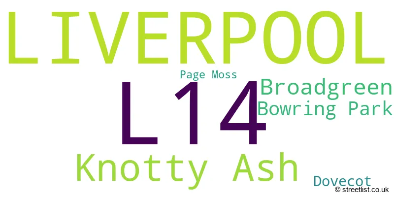
The largest settlement in the L14 postal code is LIVERPOOL followed by Knotty Ash, and Broadgreen.
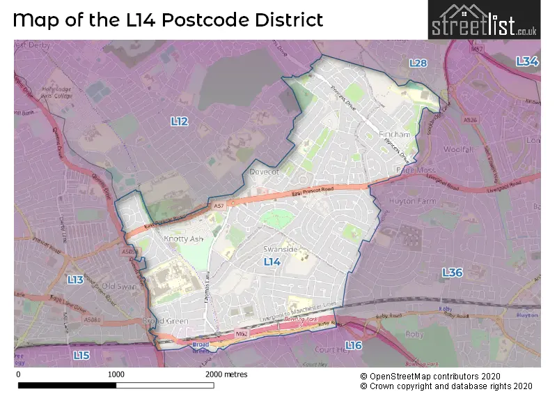
The L14 Postcode shares a border with L12 (LIVERPOOL, West Derby), L13 (LIVERPOOL, Old Swan, Tuebrook), L28 (LIVERPOOL, Stockbridge Village), L16 (LIVERPOOL, Childwall) and L36 (LIVERPOOL, Huyton).
In the L14 postcode district, the primary settlement is Liverpool, located in the county of Merseyside. Other significant settlements include Bowring Park, Knotty Ash, Broadgreen, Dovecot, and Page Moss. The most significant post town in this district is Liverpool. The county of Merseyside is located in England.
For the district L14, we have data on 10 postcode sectors. Here's a breakdown: The sector L14 0, covers Liverpool in Merseyside. The sector L14 1, covers Liverpool in Merseyside. The sector L14 2, covers Liverpool in Merseyside. The sector L14 3, covers Liverpool in Merseyside. The sector L14 4, covers Liverpool and Knotty Ash in Merseyside. The sector L14 5, covers Liverpool in Merseyside. The sector L14 6, covers Liverpool and Broadgreen in Merseyside. The sector L14 7, covers Liverpool and Knotty Ash in Merseyside. The sector L14 8, covers Liverpool in Merseyside. The sector L14 9, covers Liverpool and Knotty Ash in Merseyside.

Map of the L14 Postcode District
Explore the L14 postcode district by using our free interactive map.
When it comes to local government, postal geography often disregards political borders. However, for a breakdown in the L14 District: the district mostly encompasses the Liverpool District (B) (316 postcodes), and finally, the Knowsley District (B) area (162 postcodes).
Recent House Sales in L14
| Date | Price | Address |
|---|---|---|
| 06/10/2023 | £125,000 | Stuart Drive, Liverpool, L14 7PT |
| 03/10/2023 | £200,000 | Thomas Lane, Liverpool, L14 5NT |
| 22/09/2023 | £100,000 | Princess Drive, Liverpool, L14 8XD |
| 15/09/2023 | £120,000 | Wimborne Close, Liverpool, L14 8UH |
| 06/09/2023 | £200,000 | Pilch Lane, Liverpool, L14 0JE |
| 31/08/2023 | £213,500 | Mayfair Avenue, Bowring Park, Liverpool, L14 0JZ |
| 29/08/2023 | £185,000 | St Davids Road, Huyton, Liverpool, L14 9AE |
| 25/08/2023 | £250,000 | Warmington Road, Liverpool, L14 1QH |
| 25/08/2023 | £220,000 | Milton Avenue, Liverpool, L14 6TG |
| 25/08/2023 | £220,000 | Gordon Drive, Dovecot, Liverpool, L14 7PX |
Weather Forecast for L14
Press Button to Show Forecast for Knotty Ash
| Time Period | Icon | Description | Temperature | Rain Probability | Wind |
|---|---|---|---|---|---|
| 15:00 to 18:00 | Sunny day | 12.0°C (feels like 10.0°C) | 0.00% | NW 9 mph | |
| 18:00 to 21:00 | Sunny day | 11.0°C (feels like 9.0°C) | 1.00% | NNW 7 mph | |
| 21:00 to 00:00 | Cloudy | 9.0°C (feels like 8.0°C) | 4.00% | NE 4 mph |
Press Button to Show Forecast for Knotty Ash
| Time Period | Icon | Description | Temperature | Rain Probability | Wind |
|---|---|---|---|---|---|
| 00:00 to 03:00 | Cloudy | 8.0°C (feels like 7.0°C) | 4.00% | E 4 mph | |
| 03:00 to 06:00 | Overcast | 7.0°C (feels like 6.0°C) | 8.00% | ESE 4 mph | |
| 06:00 to 09:00 | Overcast | 7.0°C (feels like 5.0°C) | 9.00% | E 4 mph | |
| 09:00 to 12:00 | Overcast | 7.0°C (feels like 6.0°C) | 10.00% | E 4 mph | |
| 12:00 to 15:00 | Cloudy | 9.0°C (feels like 8.0°C) | 5.00% | NE 4 mph | |
| 15:00 to 18:00 | Cloudy | 10.0°C (feels like 9.0°C) | 6.00% | N 7 mph | |
| 18:00 to 21:00 | Cloudy | 10.0°C (feels like 8.0°C) | 5.00% | N 7 mph | |
| 21:00 to 00:00 | Cloudy | 8.0°C (feels like 7.0°C) | 8.00% | NNE 7 mph |
Press Button to Show Forecast for Knotty Ash
| Time Period | Icon | Description | Temperature | Rain Probability | Wind |
|---|---|---|---|---|---|
| 00:00 to 03:00 | Overcast | 8.0°C (feels like 6.0°C) | 11.00% | ENE 4 mph | |
| 03:00 to 06:00 | Light rain | 7.0°C (feels like 5.0°C) | 56.00% | SSE 4 mph | |
| 06:00 to 09:00 | Light rain | 7.0°C (feels like 5.0°C) | 58.00% | SSW 4 mph | |
| 09:00 to 12:00 | Light rain | 8.0°C (feels like 6.0°C) | 56.00% | SW 7 mph | |
| 12:00 to 15:00 | Light rain | 9.0°C (feels like 7.0°C) | 50.00% | WNW 9 mph | |
| 15:00 to 18:00 | Light rain | 10.0°C (feels like 8.0°C) | 55.00% | WNW 9 mph | |
| 18:00 to 21:00 | Cloudy | 10.0°C (feels like 8.0°C) | 10.00% | N 9 mph | |
| 21:00 to 00:00 | Cloudy | 10.0°C (feels like 8.0°C) | 7.00% | N 7 mph |
Press Button to Show Forecast for Knotty Ash
| Time Period | Icon | Description | Temperature | Rain Probability | Wind |
|---|---|---|---|---|---|
| 00:00 to 03:00 | Cloudy | 9.0°C (feels like 8.0°C) | 7.00% | N 7 mph | |
| 03:00 to 06:00 | Partly cloudy (night) | 8.0°C (feels like 6.0°C) | 2.00% | NNE 7 mph | |
| 06:00 to 09:00 | Cloudy | 7.0°C (feels like 5.0°C) | 5.00% | NNE 7 mph | |
| 09:00 to 12:00 | Cloudy | 8.0°C (feels like 6.0°C) | 5.00% | NNE 9 mph | |
| 12:00 to 15:00 | Overcast | 10.0°C (feels like 8.0°C) | 8.00% | N 9 mph | |
| 15:00 to 18:00 | Cloudy | 11.0°C (feels like 9.0°C) | 5.00% | NNW 11 mph | |
| 18:00 to 21:00 | Cloudy | 10.0°C (feels like 8.0°C) | 5.00% | N 11 mph | |
| 21:00 to 00:00 | Partly cloudy (night) | 9.0°C (feels like 6.0°C) | 2.00% | N 9 mph |
Press Button to Show Forecast for Knotty Ash
| Time Period | Icon | Description | Temperature | Rain Probability | Wind |
|---|---|---|---|---|---|
| 00:00 to 03:00 | Partly cloudy (night) | 7.0°C (feels like 5.0°C) | 2.00% | N 9 mph | |
| 03:00 to 06:00 | Clear night | 7.0°C (feels like 4.0°C) | 2.00% | N 7 mph | |
| 06:00 to 09:00 | Partly cloudy (day) | 7.0°C (feels like 4.0°C) | 3.00% | NNW 9 mph | |
| 09:00 to 12:00 | Partly cloudy (day) | 8.0°C (feels like 5.0°C) | 3.00% | NNW 11 mph | |
| 12:00 to 15:00 | Overcast | 9.0°C (feels like 7.0°C) | 9.00% | NNW 11 mph | |
| 15:00 to 18:00 | Cloudy | 10.0°C (feels like 7.0°C) | 8.00% | NNW 13 mph | |
| 18:00 to 21:00 | Cloudy | 10.0°C (feels like 7.0°C) | 6.00% | NNW 11 mph | |
| 21:00 to 00:00 | Clear night | 9.0°C (feels like 6.0°C) | 2.00% | NNW 9 mph |
Where is the L14 Postcode District?
The postcode district L14 is located in the town of Liverpool. It is situated in close proximity to several nearby towns, such as Prescot, Bootle, Widnes, St. Helens, Wallasey, Ellesmere Port, and Wirral. The distance from L14 to the centre of London is approximately 175.89 miles.
The district is within the post town of LIVERPOOL.
The sector has postcodes within the nation of England.
The L14 Postcode District is covers the following regions.
- Liverpool - Merseyside - North West (England)
- East Merseyside - Merseyside - North West (England)
Postcode Sectors within the L14 District
| Postcode Sector | Delivery Office |
|---|---|
| L14 0 | West Derby Delivery Office |
| L14 1 | West Derby Delivery Office |
| L14 2 | West Derby Delivery Office |
| L14 3 | West Derby Delivery Office |
| L14 4 | West Derby Delivery Office |
| L14 5 | West Derby Delivery Office |
| L14 6 | West Derby Delivery Office |
| L14 7 | West Derby Delivery Office |
| L14 8 | West Derby Delivery Office |
| L14 9 | West Derby Delivery Office |
| L | 1 | 4 | - | X | X | X |
| L | 1 | 4 | Space | Numeric | Letter | Letter |
Current Monthly Rental Prices
| # Bedrooms | Min Price | Max Price | Avg Price |
|---|---|---|---|
| 2 | £825 | £825 | £825 |
| 3 | £440 | £1,250 | £845 |
| 6 | £1,500 | £1,500 | £1,500 |
Current House Prices
| # Bedrooms | Min Price | Max Price | Avg Price |
|---|---|---|---|
| 2 | £36,250 | £190,000 | £121,033 |
| 3 | £82,000 | £315,000 | £188,834 |
| 4 | £98,000 | £525,000 | £295,055 |
| 6 | £275,000 | £410,000 | £342,500 |
Estate Agents who Operate in the L14 District
| Logo | Name | Brand Name | Address | Contact Number | Total Properties |
|---|---|---|---|---|---|
 | West Derby | Sutton Kersh | 18 West Derby Village, West Derby, Liverpool L12 5HW | 0151 453 5147 | 12 |
 | covering Liverpool | Purplebricks | Suite 7 First Floor Cranmore Drive Shirley Solihull B90 4RZ | 020 3907 2647 | 12 |
 | Liverpool | Strike | Nationwide | 0151 453 3496 | 10 |
 | Old Swan | Entwistle Green | 11 Broadgreen Road, Liverpool, L13 5SD | 0151 453 4018 | 9 |
 | Mossley Hill | Move Residential | 52/54 Allerton Road, Mossley Hill, Liverpool, L18 1LN | 0151 453 1497 | 9 |
| Type of Property | 2018 Average | 2018 Sales | 2017 Average | 2017 Sales | 2016 Average | 2016 Sales | 2015 Average | 2015 Sales |
|---|---|---|---|---|---|---|---|---|
| Detached | £252,366 | 58 | £261,821 | 72 | £245,397 | 68 | £236,699 | 85 |
| Semi-Detached | £134,607 | 165 | £131,462 | 176 | £126,104 | 198 | £142,333 | 166 |
| Terraced | £99,277 | 111 | £86,040 | 158 | £74,439 | 129 | £80,471 | 90 |
| Flats | £120,202 | 41 | £104,931 | 30 | £124,737 | 27 | £60,179 | 10 |