The L30 postcode district is a postal district located in the L Liverpool postcode area with a population of 19,946 residents according to the 2021 England and Wales Census.
The area of the L30 postcode district is 2.44 square miles which is 6.32 square kilometres or 1,562.16 acres.
Currently, the L30 district has about 453 postcode units spread across 10 geographic postcode sectors.
Given that each sector allows for 400 unique postcode combinations, the district has a capacity of 4,000 postcodes. With 453 postcodes already in use, this leaves 3547 units available.
The largest settlements in the L30 postal code are BOOTLE and Netherton.
The L30 Postcode shares a border with L20 (BOOTLE, LIVERPOOL, Kirkdale), L29 (LIVERPOOL, Thornton, Sefton) and L9 (LIVERPOOL, Walton, Orrell Park).
The primary settlement in the L30 postcode district is Bootle, located in the county of Merseyside, England. Other significant settlements in the district include Netherton and Atlantic Park. The main post town for the L30 postcode district is Bootle.
For the district L30, we have data on 10 postcode sectors. Here's a breakdown: The sector L30 0, covers Bootle in Merseyside. The sector L30 1, covers Bootle and Netherton in Merseyside. The sector L30 2, covers Bootle in Merseyside. The sector L30 3, covers Bootle in Merseyside. The sector L30 4, covers Bootle in Merseyside. The sector L30 5, covers Bootle in Merseyside. The sector L30 6, covers Bootle in Merseyside. The sector L30 7, covers Bootle in Merseyside. The sector L30 8, covers Bootle in Merseyside. The sector L30 9, covers Bootle in Merseyside.

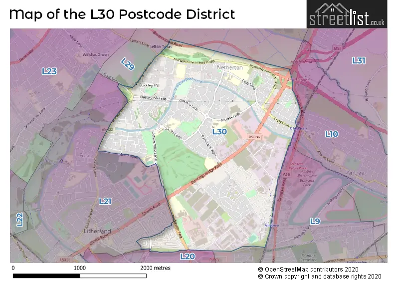
Map of the L30 Postcode District
Explore the L30 postcode district by using our free interactive map.
When it comes to local government, postal geography often disregards political borders. However, for a breakdown in the L30 District: the district mostly encompasses the Sefton District (B) area with a total of 457 postcodes.
Recent House Sales in L30
| Date | Price | Address |
|---|---|---|
| 29/09/2023 | £65,000 | Stonyfield, Bootle, L30 0RE |
| 08/09/2023 | £270,000 | Lingfield Close, Netherton, Bootle, L30 1BB |
| 04/09/2023 | £128,000 | Northumberland Way, Bootle, L30 2QB |
| 01/09/2023 | £147,000 | The Marian Way, Bootle, L30 3TB |
| 01/09/2023 | £145,000 | Orchard Hey, Bootle, L30 8RY |
| 25/08/2023 | £165,000 | Morgan Mews, Bootle, L30 2SD |
| 25/08/2023 | £105,000 | Keene Court, Bootle, L30 0PG |
| 22/08/2023 | £60,000 | Poulsom Drive, Bootle, L30 2NN |
| 18/08/2023 | £97,000 | Assissian Crescent, Bootle, L30 5QU |
| 18/08/2023 | £140,000 | Blyth Hey, Bootle, L30 2QS |
Weather Forecast for L30
Press Button to Show Forecast for Netherton
| Time Period | Icon | Description | Temperature | Rain Probability | Wind |
|---|---|---|---|---|---|
| 18:00 to 21:00 | Cloudy | 10.0°C (feels like 8.0°C) | 4.00% | NNW 11 mph | |
| 21:00 to 00:00 | Overcast | 9.0°C (feels like 8.0°C) | 7.00% | NNW 7 mph |
Press Button to Show Forecast for Netherton
| Time Period | Icon | Description | Temperature | Rain Probability | Wind |
|---|---|---|---|---|---|
| 00:00 to 03:00 | Cloudy | 9.0°C (feels like 8.0°C) | 4.00% | ENE 4 mph | |
| 03:00 to 06:00 | Cloudy | 7.0°C (feels like 6.0°C) | 3.00% | ENE 4 mph | |
| 06:00 to 09:00 | Sunny day | 6.0°C (feels like 4.0°C) | 0.00% | NNE 7 mph | |
| 09:00 to 12:00 | Sunny day | 7.0°C (feels like 6.0°C) | 0.00% | NNE 7 mph | |
| 12:00 to 15:00 | Sunny day | 10.0°C (feels like 8.0°C) | 0.00% | NNW 7 mph | |
| 15:00 to 18:00 | Sunny day | 9.0°C (feels like 7.0°C) | 1.00% | NW 11 mph | |
| 18:00 to 21:00 | Sunny day | 9.0°C (feels like 6.0°C) | 0.00% | NW 9 mph | |
| 21:00 to 00:00 | Clear night | 8.0°C (feels like 6.0°C) | 1.00% | NW 7 mph |
Press Button to Show Forecast for Netherton
| Time Period | Icon | Description | Temperature | Rain Probability | Wind |
|---|---|---|---|---|---|
| 00:00 to 03:00 | Cloudy | 7.0°C (feels like 5.0°C) | 4.00% | WNW 9 mph | |
| 03:00 to 06:00 | Cloudy | 7.0°C (feels like 4.0°C) | 4.00% | WNW 11 mph | |
| 06:00 to 09:00 | Cloudy | 8.0°C (feels like 5.0°C) | 7.00% | NW 11 mph | |
| 09:00 to 12:00 | Partly cloudy (day) | 8.0°C (feels like 5.0°C) | 5.00% | NW 13 mph | |
| 12:00 to 15:00 | Partly cloudy (day) | 9.0°C (feels like 6.0°C) | 4.00% | NW 11 mph | |
| 15:00 to 18:00 | Partly cloudy (day) | 10.0°C (feels like 7.0°C) | 2.00% | NW 11 mph | |
| 18:00 to 21:00 | Cloudy | 9.0°C (feels like 7.0°C) | 4.00% | NW 9 mph | |
| 21:00 to 00:00 | Cloudy | 8.0°C (feels like 6.0°C) | 7.00% | NNE 7 mph |
Press Button to Show Forecast for Netherton
| Time Period | Icon | Description | Temperature | Rain Probability | Wind |
|---|---|---|---|---|---|
| 00:00 to 03:00 | Cloudy | 7.0°C (feels like 5.0°C) | 7.00% | SE 7 mph | |
| 03:00 to 06:00 | Cloudy | 6.0°C (feels like 4.0°C) | 8.00% | SE 7 mph | |
| 06:00 to 09:00 | Cloudy | 6.0°C (feels like 3.0°C) | 13.00% | ESE 9 mph | |
| 09:00 to 12:00 | Cloudy | 7.0°C (feels like 5.0°C) | 12.00% | SE 9 mph | |
| 12:00 to 15:00 | Cloudy | 9.0°C (feels like 7.0°C) | 12.00% | E 9 mph | |
| 15:00 to 18:00 | Cloudy | 10.0°C (feels like 8.0°C) | 13.00% | E 7 mph | |
| 18:00 to 21:00 | Cloudy | 10.0°C (feels like 8.0°C) | 11.00% | E 7 mph | |
| 21:00 to 00:00 | Cloudy | 9.0°C (feels like 6.0°C) | 12.00% | ENE 9 mph |
Press Button to Show Forecast for Netherton
| Time Period | Icon | Description | Temperature | Rain Probability | Wind |
|---|---|---|---|---|---|
| 00:00 to 03:00 | Cloudy | 7.0°C (feels like 5.0°C) | 12.00% | ENE 9 mph | |
| 03:00 to 06:00 | Cloudy | 7.0°C (feels like 4.0°C) | 15.00% | E 9 mph | |
| 06:00 to 09:00 | Cloudy | 7.0°C (feels like 4.0°C) | 16.00% | E 9 mph | |
| 09:00 to 12:00 | Cloudy | 8.0°C (feels like 6.0°C) | 15.00% | E 9 mph | |
| 12:00 to 15:00 | Overcast | 10.0°C (feels like 8.0°C) | 18.00% | E 11 mph | |
| 15:00 to 18:00 | Cloudy | 11.0°C (feels like 9.0°C) | 41.00% | ENE 11 mph | |
| 18:00 to 21:00 | Cloudy | 10.0°C (feels like 8.0°C) | 14.00% | ENE 11 mph | |
| 21:00 to 00:00 | Cloudy | 9.0°C (feels like 7.0°C) | 14.00% | ENE 11 mph |
Where is the L30 Postcode District?
The postcode district L30 is located in Bootle. Bootle is a town in close proximity to several nearby towns. To the South East, there is Liverpool located at a distance of 2.38 miles. To the South West, there is Wallasey, which is 5.40 miles away. To the North East, Ormskirk is situated at a distance of 7.54 miles. Additionally, St. Helens is located to the East and is approximately 10.07 miles away. Moreover, the distance from Bootle to the center of London is 181.77 miles.
The district is within the post town of BOOTLE.
The sector has postcodes within the nation of England.
The L30 Postcode District is covers the following regions.
- Sefton - Merseyside - North West (England)
- East Merseyside - Merseyside - North West (England)
Postcode Sectors within the L30 District
| Postcode Sector | Delivery Office |
|---|---|
| L30 0 | Bootle Delivery Office |
| L30 1 | Bootle Delivery Office |
| L30 2 | Bootle Delivery Office |
| L30 3 | Bootle Delivery Office |
| L30 4 | Bootle Delivery Office |
| L30 5 | Bootle Delivery Office |
| L30 6 | Bootle Delivery Office |
| L30 7 | Bootle Delivery Office |
| L30 8 | Bootle Delivery Office |
| L30 9 | Bootle Delivery Office |
| L | 3 | 0 | - | X | X | X |
| L | 3 | 0 | Space | Numeric | Letter | Letter |
Current Monthly Rental Prices
| # Bedrooms | Min Price | Max Price | Avg Price |
|---|---|---|---|
| 2 | £675 | £675 | £675 |
| 3 | £725 | £800 | £763 |
Current House Prices
| # Bedrooms | Min Price | Max Price | Avg Price |
|---|---|---|---|
| 1 | £60,000 | £60,000 | £60,000 |
| 2 | £75,000 | £145,000 | £101,667 |
| 3 | £80,000 | £240,000 | £154,469 |
| 4 | £140,000 | £280,000 | £228,000 |
Estate Agents who Operate in the L30 District
| Logo | Name | Brand Name | Address | Contact Number | Total Properties |
|---|---|---|---|---|---|
 | Sefton | Whitegates | 9 Harris Drive, Bootle, Liverpool, L20 6LD | 0151 453 3896 | 15 |
 | covering Liverpool | Purplebricks | Suite 7 First Floor Cranmore Drive Shirley Solihull B90 4RZ | 020 3907 2647 | 9 |
 | Aintree | Grosvenor Waterford Estate Agents | 197 Altway, Aintree, Liverpool, L10 6LB | 0151 453 1251 | 7 |
 | Liverpool | Lyons Estates Ltd | 50 Aintree Road, Liverpool, L20 9DN | 0151 453 3674 | 5 |
 | Maghull | Entwistle Green | 26 Central Square, Maghull, Liverpool, L31 0AE | 0151 453 9798 | 4 |
| Type of Property | 2018 Average | 2018 Sales | 2017 Average | 2017 Sales | 2016 Average | 2016 Sales | 2015 Average | 2015 Sales |
|---|---|---|---|---|---|---|---|---|
| Detached | £214,222 | 9 | £213,273 | 20 | £182,216 | 50 | £174,270 | 20 |
| Semi-Detached | £124,987 | 88 | £121,028 | 84 | £120,069 | 74 | £110,941 | 63 |
| Terraced | £92,982 | 114 | £91,403 | 84 | £82,156 | 83 | £76,171 | 79 |
| Flats | £56,917 | 3 | £52,150 | 10 | £62,183 | 12 | £56,850 | 10 |