The L36 postcode district is a postal district located in the L Liverpool postcode area with a population of 42,128 residents according to the 2021 England and Wales Census.
The area of the L36 postcode district is 4.25 square miles which is 11.00 square kilometres or 2,717.36 acres.
Currently, the L36 district has about 963 postcode units spread across 10 geographic postcode sectors.
Given that each sector allows for 400 unique postcode combinations, the district has a capacity of 4,000 postcodes. With 963 postcodes already in use, this leaves 3037 units available.
The largest settlements in the L36 postal code are LIVERPOOL and Huyton.
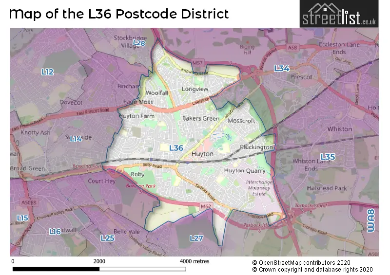
The L36 Postcode shares a border with L14 (LIVERPOOL, Knotty Ash, Broadgreen), L16 (LIVERPOOL, Childwall), L27 (LIVERPOOL, Netherley), L34 (PRESCOT, Knowsley, Eccleston Park) and L35 (Rainhill, Whiston, PRESCOT).
The primary settlement in the L36 postcode district, located in the county of Merseyside, is Liverpool. Other significant settlements in the district include Huyton and Roby. The main post town in the L36 district is Liverpool.
For the district L36, we have data on 10 postcode sectors. Here's a breakdown: The sector L36 0, covers Liverpool and Huyton in Merseyside. The sector L36 1, covers Liverpool and Huyton in Merseyside. The sector L36 2, covers Liverpool and Huyton in Merseyside. The sector L36 3, covers Liverpool and Huyton in Merseyside. The sector L36 4, covers Liverpool and Huyton in Merseyside. The sector L36 5, covers Liverpool and Huyton in Merseyside. The sector L36 6, covers Liverpool and Huyton in Merseyside. The sector L36 7, covers Liverpool in Merseyside. The sector L36 8, covers Liverpool and Huyton in Merseyside. The sector L36 9, covers Huyton and Liverpool in Merseyside.

Map of the L36 Postcode District
Explore the L36 postcode district by using our free interactive map.
When it comes to local government, postal geography often disregards political borders. However, for a breakdown in the L36 District: the district mostly encompasses the Knowsley District (B) area with a total of 961 postcodes.
Recent House Sales in L36
| Date | Price | Address |
|---|---|---|
| 03/10/2023 | £115,000 | Priory Court, Liverpool, L36 9GE |
| 29/09/2023 | £185,000 | Greenfield Drive, Liverpool, L36 0SY |
| 29/09/2023 | £122,000 | Jeffereys Crescent, Liverpool, L36 4JU |
| 19/09/2023 | £250,000 | Fields End, Liverpool, L36 5YQ |
| 08/09/2023 | £75,000 | St Gabriels Avenue, Liverpool, L36 6DW |
| 05/09/2023 | £150,000 | Oak Road, Liverpool, L36 5XY |
| 01/09/2023 | £181,000 | Merton Close, Liverpool, L36 4JD |
| 31/08/2023 | £153,000 | Arnhem Road, Liverpool, L36 7UG |
| 31/08/2023 | £258,000 | Yew Tree Road, Huyton, Liverpool, L36 5UQ |
| 31/08/2023 | £125,000 | Tarbock Road, Huyton, Liverpool, L36 5XN |
Weather Forecast for L36
Press Button to Show Forecast for Roby
| Time Period | Icon | Description | Temperature | Rain Probability | Wind |
|---|---|---|---|---|---|
| 12:00 to 15:00 | Cloudy | 11.0°C (feels like 9.0°C) | 5.00% | N 9 mph | |
| 15:00 to 18:00 | Cloudy | 11.0°C (feels like 9.0°C) | 4.00% | NNW 11 mph | |
| 18:00 to 21:00 | Cloudy | 10.0°C (feels like 8.0°C) | 4.00% | NW 11 mph | |
| 21:00 to 00:00 | Overcast | 9.0°C (feels like 7.0°C) | 7.00% | NNW 7 mph |
Press Button to Show Forecast for Roby
| Time Period | Icon | Description | Temperature | Rain Probability | Wind |
|---|---|---|---|---|---|
| 00:00 to 03:00 | Cloudy | 9.0°C (feels like 8.0°C) | 7.00% | NNW 4 mph | |
| 03:00 to 06:00 | Cloudy | 7.0°C (feels like 6.0°C) | 4.00% | ENE 4 mph | |
| 06:00 to 09:00 | Sunny day | 6.0°C (feels like 4.0°C) | 0.00% | NNE 7 mph | |
| 09:00 to 12:00 | Sunny day | 8.0°C (feels like 6.0°C) | 0.00% | NNE 7 mph | |
| 12:00 to 15:00 | Partly cloudy (day) | 10.0°C (feels like 9.0°C) | 1.00% | N 7 mph | |
| 15:00 to 18:00 | Partly cloudy (day) | 11.0°C (feels like 8.0°C) | 1.00% | NW 9 mph | |
| 18:00 to 21:00 | Sunny day | 9.0°C (feels like 7.0°C) | 0.00% | NW 9 mph | |
| 21:00 to 00:00 | Clear night | 7.0°C (feels like 5.0°C) | 1.00% | NW 7 mph |
Press Button to Show Forecast for Roby
| Time Period | Icon | Description | Temperature | Rain Probability | Wind |
|---|---|---|---|---|---|
| 00:00 to 03:00 | Cloudy | 7.0°C (feels like 5.0°C) | 4.00% | WNW 7 mph | |
| 03:00 to 06:00 | Cloudy | 7.0°C (feels like 4.0°C) | 4.00% | WNW 9 mph | |
| 06:00 to 09:00 | Cloudy | 7.0°C (feels like 4.0°C) | 7.00% | WNW 9 mph | |
| 09:00 to 12:00 | Cloudy | 8.0°C (feels like 5.0°C) | 8.00% | NW 11 mph | |
| 12:00 to 15:00 | Partly cloudy (day) | 10.0°C (feels like 7.0°C) | 6.00% | NW 11 mph | |
| 15:00 to 18:00 | Partly cloudy (day) | 10.0°C (feels like 8.0°C) | 3.00% | NW 11 mph | |
| 18:00 to 21:00 | Cloudy | 9.0°C (feels like 8.0°C) | 6.00% | NNW 7 mph | |
| 21:00 to 00:00 | Cloudy | 8.0°C (feels like 6.0°C) | 5.00% | NNE 4 mph |
Press Button to Show Forecast for Roby
| Time Period | Icon | Description | Temperature | Rain Probability | Wind |
|---|---|---|---|---|---|
| 00:00 to 03:00 | Cloudy | 7.0°C (feels like 5.0°C) | 7.00% | E 7 mph | |
| 03:00 to 06:00 | Cloudy | 5.0°C (feels like 3.0°C) | 11.00% | SE 7 mph | |
| 06:00 to 09:00 | Cloudy | 5.0°C (feels like 2.0°C) | 11.00% | ESE 7 mph | |
| 09:00 to 12:00 | Cloudy | 7.0°C (feels like 5.0°C) | 12.00% | ESE 9 mph | |
| 12:00 to 15:00 | Overcast | 9.0°C (feels like 7.0°C) | 15.00% | E 7 mph | |
| 15:00 to 18:00 | Overcast | 10.0°C (feels like 8.0°C) | 18.00% | ENE 7 mph | |
| 18:00 to 21:00 | Cloudy | 10.0°C (feels like 8.0°C) | 12.00% | E 7 mph | |
| 21:00 to 00:00 | Overcast | 8.0°C (feels like 6.0°C) | 17.00% | ENE 9 mph |
Press Button to Show Forecast for Roby
| Time Period | Icon | Description | Temperature | Rain Probability | Wind |
|---|---|---|---|---|---|
| 00:00 to 03:00 | Cloudy | 7.0°C (feels like 4.0°C) | 15.00% | ENE 9 mph | |
| 03:00 to 06:00 | Overcast | 6.0°C (feels like 4.0°C) | 21.00% | E 9 mph | |
| 06:00 to 09:00 | Cloudy | 6.0°C (feels like 4.0°C) | 17.00% | E 9 mph | |
| 09:00 to 12:00 | Cloudy | 8.0°C (feels like 6.0°C) | 17.00% | E 9 mph | |
| 12:00 to 15:00 | Overcast | 11.0°C (feels like 8.0°C) | 19.00% | E 9 mph | |
| 15:00 to 18:00 | Cloudy | 11.0°C (feels like 9.0°C) | 17.00% | ENE 11 mph | |
| 18:00 to 21:00 | Cloudy | 11.0°C (feels like 8.0°C) | 15.00% | ENE 9 mph | |
| 21:00 to 00:00 | Cloudy | 9.0°C (feels like 7.0°C) | 15.00% | ENE 9 mph |
Where is the L36 Postcode District?
The data suggests that the postcode district L36 is located in LIVERPOOL. It is worth noting that the nearby towns are PRESCOT (2.01 miles East), WIDNES (4.63 miles South East), ST. HELENS (5.57 miles North East), BOOTLE (7.00 miles North West), WALLASEY (8.66 miles West), and ELLESMERE PORT (9.06 miles South). Additionally, the distance between L36 postcode district and London's center is approximately 174.54 miles.
The district is within the post town of LIVERPOOL.
The sector has postcodes within the nation of England.
The L36 Postcode District is in the East Merseyside region of Merseyside within the North West (England).
Postcode Sectors within the L36 District
| Postcode Sector | Delivery Office |
|---|---|
| L36 0 | Huyton Delivery Office |
| L36 1 | Huyton Delivery Office |
| L36 2 | Huyton Delivery Office |
| L36 3 | Huyton Delivery Office |
| L36 4 | Huyton Delivery Office |
| L36 5 | Huyton Delivery Office |
| L36 6 | Huyton Delivery Office |
| L36 7 | Huyton Delivery Office |
| L36 8 | Huyton Delivery Office |
| L36 9 | Huyton Delivery Office |
| L | 3 | 6 | - | X | X | X |
| L | 3 | 6 | Space | Numeric | Letter | Letter |
Current Monthly Rental Prices
| # Bedrooms | Min Price | Max Price | Avg Price |
|---|---|---|---|
| 2 | £650 | £1,000 | £741 |
| 3 | £750 | £1,500 | £1,010 |
Current House Prices
| # Bedrooms | Min Price | Max Price | Avg Price |
|---|---|---|---|
| £6,000 | £6,000 | £6,000 | |
| 1 | £70,000 | £100,000 | £84,158 |
| 2 | £60,000 | £220,000 | £120,796 |
| 3 | £75,000 | £375,000 | £197,280 |
| 4 | £105,000 | £740,000 | £317,000 |
| 5 | £340,000 | £525,000 | £418,333 |
Estate Agents who Operate in the L36 District
| Logo | Name | Brand Name | Address | Contact Number | Total Properties |
|---|---|---|---|---|---|
 | Huyton | Whitegates | 1 Tarbock Road, Roby, Liverpool, L36 5YB | 0151 453 0810 | 31 |
 | Huyton | Cameron Mackenzie | 17 Tarbock Road, Huyton, Liverpool, L36 5XN | 0151 453 8807 | 27 |
 | covering Liverpool | Purplebricks | Suite 7 First Floor Cranmore Drive Shirley Solihull B90 4RZ | 020 3907 2647 | 12 |
 | Liverpool | Strike | Nationwide | 0151 453 3496 | 4 |
 | Prescot | Reeds Rains | 18 Eccleston Street Prescot L34 5QE | 0151 453 8584 | 4 |
| Type of Property | 2018 Average | 2018 Sales | 2017 Average | 2017 Sales | 2016 Average | 2016 Sales | 2015 Average | 2015 Sales |
|---|---|---|---|---|---|---|---|---|
| Detached | £232,078 | 100 | £243,666 | 143 | £208,064 | 75 | £179,203 | 71 |
| Semi-Detached | £144,151 | 301 | £140,030 | 284 | £136,910 | 262 | £127,060 | 219 |
| Terraced | £92,493 | 173 | £94,528 | 165 | £86,329 | 154 | £80,895 | 140 |
| Flats | £83,498 | 42 | £73,246 | 32 | £68,129 | 38 | £67,050 | 40 |