The LA6 postcode district is a postal district located in the LA Lancaster postcode area with a population of 13,193 residents according to the 2021 England and Wales Census.
The area of the LA6 postcode district is 139.51 square miles which is 361.34 square kilometres or 89,287.91 acres.
Currently, the LA6 district has about 669 postcode units spread across 3 geographic postcode sectors.
Given that each sector allows for 400 unique postcode combinations, the district has a capacity of 1,200 postcodes. With 669 postcodes already in use, this leaves 531 units available.
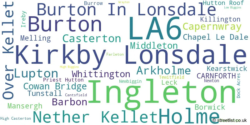
The largest settlement in the LA6 postal code is Ingleton followed by Kirkby Lonsdale, and Holme.
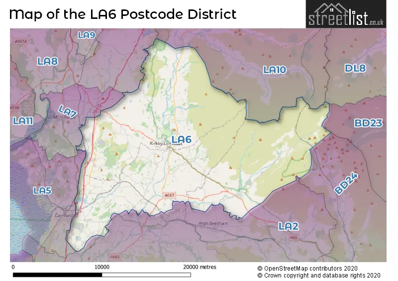
The LA6 Postcode shares a border with LA10 (SEDBERGH, Dent, Garsdale), LA2 (Bentham, Ellel, Halton), LA8 (Staveley, Levens, Endmoor), LA5 (CARNFORTH, Bolton Le Sands, Arnside) and LA7 (MILNTHORPE, Storth, Heversham).
In the LA6 postcode district, the primary settlement is Carnforth, which is located in both Lancashire and Cumbria counties. The most significant post town in the district is Carnforth as well. Other significant settlements in the LA6 postcode district include Arkholme, Borwick, Capernwray, Clawthorpe, Dock Acres, Farleton, Holme, Lupton, Nether Kellet, Over Kellet, Priest Hutton, and Tewitfield.
For the district LA6, we have data on 3 postcode sectors. Here's a breakdown: The sector LA6 1, covers Burton and Holme in Cumbria. The sector LA6 1, covers Nether Kellet and Over Kellet in Lancashire. The sector LA6 2, covers Kirkby Lonsdale in Cumbria. The sector LA6 3, covers Ingleton and Burton In Lonsdale in North Yorkshire.

Map of the LA6 Postcode District
Explore the LA6 postcode district by using our free interactive map.
When it comes to local government, postal geography often disregards political borders. However, for a breakdown in the LA6 District: the district mostly encompasses the Westmorland and Furness (302 postcodes), followed by the Lancaster District (B) area (188 postcodes), and finally, the North Yorkshire area (185 postcodes).
Recent House Sales in LA6
| Date | Price | Address |
|---|---|---|
| 20/10/2023 | £235,000 | Highfield Cottages, Ingleton, Carnforth, LA6 3AZ |
| 18/10/2023 | £153,000 | Old Laundry Mews, Ingleton, Carnforth, LA6 3GH |
| 22/09/2023 | £550,000 | Dalton, Carnforth, LA6 1NN |
| 11/09/2023 | £320,000 | Halton Road, Nether Kellet, Carnforth, LA6 1EU |
| 08/09/2023 | £275,000 | Ingleton, Carnforth, LA6 3BY |
| 06/09/2023 | £265,000 | Pear Tree Park, Holme, Carnforth, LA6 1PP |
| 06/09/2023 | £190,000 | Chestnut Close, Holme, Carnforth, LA6 1RW |
| 04/09/2023 | £180,000 | Farleton View, Holme, Carnforth, LA6 1QU |
| 31/08/2023 | £212,500 | Holme Mills Cottages, Holme, Carnforth, LA6 1RB |
| 31/08/2023 | £621,000 | Masongill, Carnforth, LA6 3NN |
Weather Forecast for LA6
Press Button to Show Forecast for Leck Fell
| Time Period | Icon | Description | Temperature | Rain Probability | Wind |
|---|---|---|---|---|---|
| 12:00 to 15:00 | Cloudy | 8.0°C (feels like 6.0°C) | 7.00% | NNE 9 mph | |
| 15:00 to 18:00 | Cloudy | 8.0°C (feels like 6.0°C) | 7.00% | NNE 9 mph | |
| 18:00 to 21:00 | Cloudy | 6.0°C (feels like 3.0°C) | 5.00% | ENE 9 mph | |
| 21:00 to 00:00 | Clear night | 3.0°C (feels like 0.0°C) | 1.00% | ENE 7 mph |
Press Button to Show Forecast for Leck Fell
| Time Period | Icon | Description | Temperature | Rain Probability | Wind |
|---|---|---|---|---|---|
| 00:00 to 03:00 | Clear night | 0.0°C (feels like -2.0°C) | 0.00% | ENE 4 mph | |
| 03:00 to 06:00 | Clear night | 0.0°C (feels like -3.0°C) | 2.00% | ENE 4 mph | |
| 06:00 to 09:00 | Sunny day | 1.0°C (feels like -1.0°C) | 1.00% | ENE 4 mph | |
| 09:00 to 12:00 | Cloudy | 5.0°C (feels like 4.0°C) | 5.00% | ESE 4 mph | |
| 12:00 to 15:00 | Overcast | 7.0°C (feels like 5.0°C) | 18.00% | E 4 mph | |
| 15:00 to 18:00 | Light rain | 7.0°C (feels like 6.0°C) | 40.00% | SE 4 mph | |
| 18:00 to 21:00 | Partly cloudy (day) | 6.0°C (feels like 5.0°C) | 7.00% | E 4 mph | |
| 21:00 to 00:00 | Partly cloudy (night) | 3.0°C (feels like 1.0°C) | 2.00% | ENE 4 mph |
Press Button to Show Forecast for Leck Fell
| Time Period | Icon | Description | Temperature | Rain Probability | Wind |
|---|---|---|---|---|---|
| 00:00 to 03:00 | Clear night | 2.0°C (feels like -1.0°C) | 2.00% | E 4 mph | |
| 03:00 to 06:00 | Clear night | 1.0°C (feels like -1.0°C) | 3.00% | ENE 4 mph | |
| 06:00 to 09:00 | Partly cloudy (day) | 2.0°C (feels like 0.0°C) | 3.00% | ENE 4 mph | |
| 09:00 to 12:00 | Partly cloudy (day) | 6.0°C (feels like 4.0°C) | 6.00% | ESE 7 mph | |
| 12:00 to 15:00 | Overcast | 8.0°C (feels like 7.0°C) | 13.00% | ESE 7 mph | |
| 15:00 to 18:00 | Cloudy | 9.0°C (feels like 7.0°C) | 10.00% | E 7 mph | |
| 18:00 to 21:00 | Cloudy | 8.0°C (feels like 5.0°C) | 11.00% | E 9 mph | |
| 21:00 to 00:00 | Partly cloudy (night) | 4.0°C (feels like 2.0°C) | 9.00% | ENE 7 mph |
Press Button to Show Forecast for Leck Fell
| Time Period | Icon | Description | Temperature | Rain Probability | Wind |
|---|---|---|---|---|---|
| 00:00 to 03:00 | Cloudy | 3.0°C (feels like 0.0°C) | 13.00% | NE 7 mph | |
| 03:00 to 06:00 | Cloudy | 3.0°C (feels like 0.0°C) | 12.00% | NE 9 mph | |
| 06:00 to 09:00 | Cloudy | 5.0°C (feels like 1.0°C) | 15.00% | NE 11 mph | |
| 09:00 to 12:00 | Cloudy | 6.0°C (feels like 3.0°C) | 19.00% | NE 11 mph | |
| 12:00 to 15:00 | Light rain | 8.0°C (feels like 5.0°C) | 48.00% | NE 9 mph | |
| 15:00 to 18:00 | Light rain | 8.0°C (feels like 6.0°C) | 54.00% | NNE 9 mph | |
| 18:00 to 21:00 | Cloudy | 8.0°C (feels like 6.0°C) | 20.00% | E 7 mph | |
| 21:00 to 00:00 | Partly cloudy (night) | 5.0°C (feels like 3.0°C) | 10.00% | NNW 4 mph |
Where is the LA6 Postcode District?
The postcode district for LA6 is located in Carnforth. Carnforth is situated in close proximity to several nearby towns, including Sedbergh to the north, Milnthorpe to the west, Kendal to the northwest, Hawes to the northeast, Lancaster to the southwest, and Settle to the southeast. It is important to note that Carnforth is approximately 212.02 miles away from the center of London.
The district is within the post town of CARNFORTH.
The sector has postcodes within the nation of England.
The LA6 Postcode District is covers the following regions.
- Lancaster and Wyre - Lancashire - North West (England)
- East Cumbria - Cumbria - North West (England)
- North Yorkshire CC - North Yorkshire - Yorkshire and The Humber
| Postcode Sector | Delivery Office |
|---|---|
| LA6 1 | Carnforth Delivery Office |
| LA6 2 | Kirkby Lonsdale Scale Payment Delivery Office |
| LA6 3 | Carnforth Delivery Office |
| LA6 3 | Ingleton Scale Payment Delivery Office |
| L | A | 6 | - | X | X | X |
| L | A | 6 | Space | Numeric | Letter | Letter |
Current Monthly Rental Prices
| # Bedrooms | Min Price | Max Price | Avg Price |
|---|---|---|---|
| 2 | £950 | £950 | £950 |
| 3 | £625 | £1,250 | £925 |
| 4 | £1,250 | £2,000 | £1,617 |
Current House Prices
| # Bedrooms | Min Price | Max Price | Avg Price |
|---|---|---|---|
| £150,000 | £2,800,000 | £1,025,000 | |
| 1 | £110,000 | £235,000 | £181,667 |
| 2 | £21,500 | £750,000 | £161,083 |
| 3 | £80,000 | £1,200,000 | £354,333 |
| 4 | £270,000 | £1,500,000 | £584,432 |
| 5 | £275,000 | £1,500,000 | £811,500 |
| 6 | £315,000 | £1,075,000 | £695,000 |
| 7 | £2,000,000 | £2,000,000 | £2,000,000 |
Estate Agents who Operate in the LA6 District
| Logo | Name | Brand Name | Address | Contact Number | Total Properties |
|---|---|---|---|---|---|
 | Lytham | Sell My Group | The Old Bakery Green Street, Lytham, Lytham St. Annes, FY8 5LG | 020 3910 6164 | 24 |
 | Kirkby Lonsdale | Hackney & Leigh | 3 Market Square Kirkby Lonsdale Cumbria LA6 2AN | 01524 938547 | 21 |
 | Kirkby Lonsdale | Davis & Bowring | Lane House, Kendal Road, Kirkby Lonsdale, Via Carnforth, LA6 2HH | 01524 274445 | 18 |
 | Bentham | Fisher Hopper | 43 Main Street, Bentham, LA2 7HJ | 01524 969618 | 14 |
 | Carnforth | Hackney & Leigh | Market Street, Carnforth, LA5 9BT | 01524 235887 | 12 |
- Arkholme
- Barbon
- Borwick
- Burton-in-Kendal
- Burton in Lonsdale
- Capernwray
- Carnforth
- Casterton
- Chapel-le-Dale
- Clawthorpe
- Farleton
- Holme
- Hutton Roof
- Ingleton
- Ireby
- Kearstwick
- Kirkby Lonsdale
- Leck
- Low Biggins
- Lupton
- Melling
- Middleton
- Millness
- Nether Burrow
- Nether Kellet
- Old Hutton
- Over Kellet
- Priest Hutton
- Tewitfield
- Tunstall
- Whittington
- Yealand Conyers
| Type of Property | 2018 Average | 2018 Sales | 2017 Average | 2017 Sales | 2016 Average | 2016 Sales | 2015 Average | 2015 Sales |
|---|---|---|---|---|---|---|---|---|
| Detached | £341,672 | 86 | £348,892 | 81 | £345,784 | 71 | £345,868 | 95 |
| Semi-Detached | £244,419 | 73 | £256,161 | 50 | £233,048 | 47 | £224,517 | 52 |
| Terraced | £204,415 | 85 | £206,437 | 62 | £215,723 | 76 | £211,644 | 71 |
| Flats | £178,435 | 23 | £169,550 | 10 | £234,173 | 18 | £160,708 | 19 |