The LE4 postcode district is a postal district located in the LE Leicester postcode area with a population of 108,997 residents according to the 2021 England and Wales Census.
The area of the LE4 postcode district is 11.57 square miles which is 29.96 square kilometres or 7,404.40 acres.
Currently, the LE4 district has about 1833 postcode units spread across 10 geographic postcode sectors.
Given that each sector allows for 400 unique postcode combinations, the district has a capacity of 4,000 postcodes. With 1833 postcodes already in use, this leaves 2167 units available.
The largest settlement in the LE4 postal code is LEICESTER followed by Birstall, and Thurmaston.
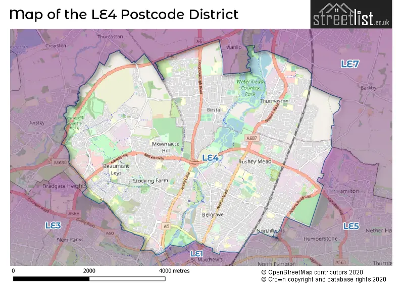
The LE4 Postcode shares a border with LE1 (LEICESTER), LE3 (LEICESTER, Glenfield, Leicester Forest East), LE5 (LEICESTER, Hamilton, Evington) and LE7 (Syston, Anstey, Rothley).
The primary settlement in the LE4 postcode district is Leicester, which is located in the county of Leicestershire, England. Other significant settlements within this postcode district include Birstall and Thurmaston. The most significant post town in this district is also Leicester.
For the district LE4, we have data on 10 postcode sectors. Here's a breakdown: The sector LE4 0, covers Leicester in Leicestershire. The sector LE4 1, covers Leicester in Leicestershire. The sector LE4 2, covers Leicester in Leicestershire. The sector LE4 3, covers Birstall in Leicestershire. The sector LE4 4, covers Birstall in Leicestershire. The sector LE4 5, covers Leicester in Leicestershire. The sector LE4 6, covers Leicester in Leicestershire. The sector LE4 7, covers Leicester in Leicestershire. The sector LE4 8, covers Thurmaston in Leicestershire. The sector LE4 9, covers Leicester in Leicestershire.

Map of the LE4 Postcode District
Explore the LE4 postcode district by using our free interactive map.
When it comes to local government, postal geography often disregards political borders. However, for a breakdown in the LE4 District: the district mostly encompasses the City of Leicester (B) (1314 postcodes), followed by the Charnwood District (B) area (528 postcodes), and finally, the Blaby District area (5 postcodes).
Recent House Sales in LE4
| Date | Price | Address |
|---|---|---|
| 12/10/2023 | £300,000 | Wanlip Avenue, Birstall, Leicester, LE4 4JP |
| 04/10/2023 | £300,000 | Queensgate Drive, Birstall, Leicester, LE4 3JR |
| 04/10/2023 | £100,000 | Wanlip Lane, Birstall, Leicester, LE4 4JU |
| 02/10/2023 | £225,000 | Upper Temple Walk, Leicester, LE4 0SA |
| 29/09/2023 | £345,000 | Wye Close, Leicester, LE4 9AZ |
| 22/09/2023 | £203,000 | Hartshorn Close, Thurmaston, Leicester, LE4 8LL |
| 22/09/2023 | £180,000 | Victoria Street, Thurmaston, Leicester, LE4 8GG |
| 19/09/2023 | £377,000 | Cliffwood Avenue, Birstall, Leicester, LE4 3DD |
| 18/09/2023 | £205,000 | Barnwell Avenue, Leicester, LE4 2TB |
| 14/09/2023 | £230,000 | Burfield Street, Leicester, LE4 6AL |
Weather Forecast for LE4
Press Button to Show Forecast for Belgrave
| Time Period | Icon | Description | Temperature | Rain Probability | Wind |
|---|---|---|---|---|---|
| 00:00 to 03:00 | Overcast | 6.0°C (feels like 4.0°C) | 7.00% | NNW 7 mph | |
| 03:00 to 06:00 | Cloudy | 5.0°C (feels like 3.0°C) | 3.00% | NNW 7 mph | |
| 06:00 to 09:00 | Cloudy | 5.0°C (feels like 2.0°C) | 3.00% | NNW 7 mph | |
| 09:00 to 12:00 | Cloudy | 7.0°C (feels like 4.0°C) | 3.00% | N 11 mph | |
| 12:00 to 15:00 | Overcast | 9.0°C (feels like 6.0°C) | 8.00% | N 11 mph | |
| 15:00 to 18:00 | Cloudy | 10.0°C (feels like 8.0°C) | 4.00% | N 9 mph | |
| 18:00 to 21:00 | Cloudy | 9.0°C (feels like 8.0°C) | 4.00% | NNE 7 mph | |
| 21:00 to 00:00 | Cloudy | 7.0°C (feels like 5.0°C) | 4.00% | E 4 mph |
Press Button to Show Forecast for Belgrave
| Time Period | Icon | Description | Temperature | Rain Probability | Wind |
|---|---|---|---|---|---|
| 00:00 to 03:00 | Cloudy | 5.0°C (feels like 3.0°C) | 4.00% | WSW 4 mph | |
| 03:00 to 06:00 | Cloudy | 4.0°C (feels like 2.0°C) | 4.00% | WSW 7 mph | |
| 06:00 to 09:00 | Cloudy | 5.0°C (feels like 2.0°C) | 6.00% | W 9 mph | |
| 09:00 to 12:00 | Overcast | 8.0°C (feels like 5.0°C) | 12.00% | WNW 11 mph | |
| 12:00 to 15:00 | Cloudy | 9.0°C (feels like 7.0°C) | 12.00% | NW 9 mph | |
| 15:00 to 18:00 | Cloudy | 10.0°C (feels like 8.0°C) | 10.00% | NW 9 mph | |
| 18:00 to 21:00 | Cloudy | 8.0°C (feels like 7.0°C) | 10.00% | N 7 mph | |
| 21:00 to 00:00 | Cloudy | 6.0°C (feels like 5.0°C) | 5.00% | NNE 4 mph |
Press Button to Show Forecast for Belgrave
| Time Period | Icon | Description | Temperature | Rain Probability | Wind |
|---|---|---|---|---|---|
| 00:00 to 03:00 | Partly cloudy (night) | 5.0°C (feels like 3.0°C) | 1.00% | NE 4 mph | |
| 03:00 to 06:00 | Cloudy | 3.0°C (feels like 1.0°C) | 5.00% | ENE 4 mph | |
| 06:00 to 09:00 | Cloudy | 4.0°C (feels like 2.0°C) | 9.00% | ENE 4 mph | |
| 09:00 to 12:00 | Cloudy | 7.0°C (feels like 5.0°C) | 11.00% | E 7 mph | |
| 12:00 to 15:00 | Overcast | 10.0°C (feels like 8.0°C) | 17.00% | E 7 mph | |
| 15:00 to 18:00 | Overcast | 10.0°C (feels like 8.0°C) | 18.00% | ESE 9 mph | |
| 18:00 to 21:00 | Overcast | 9.0°C (feels like 7.0°C) | 16.00% | E 9 mph | |
| 21:00 to 00:00 | Overcast | 7.0°C (feels like 5.0°C) | 16.00% | ESE 9 mph |
Press Button to Show Forecast for Belgrave
| Time Period | Icon | Description | Temperature | Rain Probability | Wind |
|---|---|---|---|---|---|
| 00:00 to 03:00 | Cloudy | 6.0°C (feels like 4.0°C) | 20.00% | ESE 9 mph | |
| 03:00 to 06:00 | Overcast | 6.0°C (feels like 3.0°C) | 23.00% | E 7 mph | |
| 06:00 to 09:00 | Cloudy | 6.0°C (feels like 4.0°C) | 17.00% | ENE 9 mph | |
| 09:00 to 12:00 | Overcast | 9.0°C (feels like 6.0°C) | 18.00% | E 9 mph | |
| 12:00 to 15:00 | Overcast | 12.0°C (feels like 9.0°C) | 21.00% | E 9 mph | |
| 15:00 to 18:00 | Cloudy | 12.0°C (feels like 10.0°C) | 19.00% | E 11 mph | |
| 18:00 to 21:00 | Light rain shower (day) | 11.0°C (feels like 9.0°C) | 35.00% | ENE 9 mph | |
| 21:00 to 00:00 | Cloudy | 9.0°C (feels like 7.0°C) | 17.00% | E 9 mph |
Where is the LE4 Postcode District?
The data shows that the LE4 postcode district is located in Leicester. It is closely associated with nearby towns such as Wigston, Markfield, Loughborough, Melton Mowbray, and Hinckley. Additionally, it is situated approximately 90.81 miles away from the center of London.
The district is within the post town of LEICESTER.
The sector has postcodes within the nation of England.
The LE4 Postcode District is covers the following regions.
- Leicester - Leicestershire, Rutland and Northamptonshire - East Midlands (England)
- Leicestershire CC and Rutland - Leicestershire, Rutland and Northamptonshire - East Midlands (England)
Postcode Sectors within the LE4 District
| Postcode Sector | Delivery Office |
|---|---|
| LE4 0 | Leicester North Delivery Office |
| LE4 1 | Leicester North Delivery Office |
| LE4 2 | Leicester North Delivery Office |
| LE4 3 | Leicester North Delivery Office |
| LE4 4 | Leicester North Delivery Office |
| LE4 5 | Leicester North Delivery Office |
| LE4 6 | Leicester North Delivery Office |
| LE4 7 | Leicester North Delivery Office |
| LE4 8 | Leicester North Delivery Office |
| LE4 9 | Leicester North Delivery Office |
| L | E | 4 | - | X | X | X |
| L | E | 4 | Space | Numeric | Letter | Letter |
Tourist Attractions within the Postcode Area
We found 3 visitor attractions within the LE4 postcode area
| National Space Centre |
|---|
| Museums & Art Galleries |
| Science / Technology Centre |
| View National Space Centre on Google Maps |
| Abbey Pumping Station |
| Museums & Art Galleries |
| Museum and / or Art Gallery |
| View Abbey Pumping Station on Google Maps |
| Belgrave Hall |
| Historic Properties |
| Other Historic Property |
| View Belgrave Hall on Google Maps |
Current Monthly Rental Prices
| # Bedrooms | Min Price | Max Price | Avg Price |
|---|---|---|---|
| £550 | £550 | £550 | |
| 1 | £525 | £840 | £698 |
| 2 | £795 | £1,250 | £939 |
| 3 | £795 | £1,300 | £1,100 |
| 4 | £1,250 | £1,553 | £1,408 |
| 5 | £2,000 | £2,000 | £2,000 |
| 10 | £4,950 | £5,000 | £4,975 |
Current House Prices
| # Bedrooms | Min Price | Max Price | Avg Price |
|---|---|---|---|
| £60,000 | £85,000 | £71,250 | |
| 1 | £100,000 | £325,000 | £178,265 |
| 2 | £95,000 | £470,000 | £222,617 |
| 3 | £105,000 | £495,000 | £291,083 |
| 4 | £235,000 | £575,000 | £397,687 |
| 5 | £280,000 | £749,995 | £476,826 |
| 6 | £360,000 | £515,000 | £428,998 |
Estate Agents who Operate in the LE4 District
| Logo | Name | Brand Name | Address | Contact Number | Total Properties |
|---|---|---|---|---|---|
 | Leicester | Seths Estate & Letting Agents | 20 Loughborough Road, Belgrave, Leicester, LE4 5LD | 0116 266 9977 | 40 |
 | covering Leicestershire | Purplebricks | Suite 7 First Floor Cranmore Drive Shirley Solihull B90 4RZ | 0116 497 6909 | 32 |
 | Birstall | Spencers Estate Agency | 109 Sibson Road, Birstall, Leicester, LE4 4NB | 0116 216 1157 | 20 |
 | Syston | Newton Fallowell | 1250 Melton Road, Syston, Leicester, LE7 2HD | 0116 344 0110 | 15 |
 | Leicester | Connells | 22-24 Halford Street, Leicester, LE1 1JB | 0116 216 3259 | 14 |
| Type of Property | 2018 Average | 2018 Sales | 2017 Average | 2017 Sales | 2016 Average | 2016 Sales | 2015 Average | 2015 Sales |
|---|---|---|---|---|---|---|---|---|
| Detached | £266,323 | 209 | £245,060 | 177 | £230,289 | 175 | £222,083 | 190 |
| Semi-Detached | £187,405 | 485 | £176,758 | 502 | £163,529 | 419 | £154,837 | 427 |
| Terraced | £168,020 | 372 | £158,724 | 386 | £146,119 | 394 | £126,879 | 386 |
| Flats | £114,324 | 76 | £112,581 | 80 | £102,940 | 67 | £91,911 | 70 |