The LE5 postcode district is a postal district located in the LE Leicester postcode area with a population of 99,623 residents according to the 2021 England and Wales Census.
The area of the LE5 postcode district is 6.38 square miles which is 16.52 square kilometres or 4,081.42 acres.
Currently, the LE5 district has about 1449 postcode units spread across 7 geographic postcode sectors.
Given that each sector allows for 400 unique postcode combinations, the district has a capacity of 2,800 postcodes. With 1449 postcodes already in use, this leaves 1351 units available.
The largest settlement in the LE5 postal code is LEICESTER followed by Hamilton, and Evington.
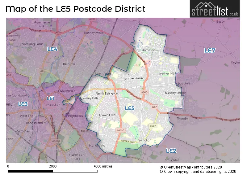
The LE5 Postcode shares a border with LE1 (LEICESTER), LE2 (LEICESTER, Oadby, Glen Parva), LE4 (LEICESTER, Birstall, Thurmaston) and LE7 (Syston, Anstey, Rothley).
The primary settlement in the LE5 postcode district is Leicester, located in the county of Leicestershire, England. Other significant settlements within this postcode district include Hamilton and Humberstone. The most significant post town in this district is Leicester.
For the district LE5, we have data on 8 postcode sectors. Here's a breakdown: The sector LE5 0, covers Leicester in Leicestershire. The sector LE5 1, covers Hamilton and Leicester in Leicestershire. The sector LE5 2, covers Leicester in Leicestershire. The sector LE5 3, covers Leicester in Leicestershire. The sector LE5 4, covers Leicester in Leicestershire. The sector LE5 5, covers Leicester in Leicestershire. The sector LE5 6, covers Leicester in Leicestershire. The sector LE5 9 is non-geographic. It's often designated for PO Boxes, large organisations, or special services.


Map of the LE5 Postcode District
Explore the LE5 postcode district by using our free interactive map.
When it comes to local government, postal geography often disregards political borders. However, for a breakdown in the LE5 District: the district mostly encompasses the City of Leicester (B) (1408 postcodes), followed by the Blaby District area (27 postcodes), followed by the Charnwood District (B) area (16 postcodes), and finally, the Harborough District area (3 postcodes).
Recent House Sales in LE5
| Date | Price | Address |
|---|---|---|
| 20/10/2023 | £252,000 | Grove Road, Leicester, LE5 3HG |
| 13/10/2023 | £255,000 | Perkyn Road, Leicester, LE5 2EX |
| 09/10/2023 | £483,500 | The Hollow, Evington, Leicester, LE5 6DU |
| 02/10/2023 | £450,000 | Kingsway Road, Leicester, LE5 5TT |
| 29/09/2023 | £328,000 | Stambourne Road, Leicester, LE5 0TZ |
| 29/09/2023 | £315,000 | Birkby Close, Hamilton, Leicester, LE5 1PS |
| 25/09/2023 | £260,000 | St Saviours Road, Leicester, LE5 3SH |
| 22/09/2023 | £150,000 | Okehampton Avenue, Leicester, LE5 5NS |
| 20/09/2023 | £200,000 | Asfordby Street, Leicester, LE5 3QG |
| 18/09/2023 | £262,000 | Hollybush Close, Leicester, LE5 2HZ |
Weather Forecast for LE5
Press Button to Show Forecast for Humberstone
| Time Period | Icon | Description | Temperature | Rain Probability | Wind |
|---|---|---|---|---|---|
| 09:00 to 12:00 | Overcast | 7.0°C (feels like 4.0°C) | 11.00% | NNW 9 mph | |
| 12:00 to 15:00 | Overcast | 9.0°C (feels like 6.0°C) | 9.00% | N 11 mph | |
| 15:00 to 18:00 | Overcast | 11.0°C (feels like 8.0°C) | 8.00% | N 13 mph | |
| 18:00 to 21:00 | Cloudy | 9.0°C (feels like 7.0°C) | 7.00% | NNE 11 mph | |
| 21:00 to 00:00 | Cloudy | 7.0°C (feels like 5.0°C) | 5.00% | N 7 mph |
Press Button to Show Forecast for Humberstone
| Time Period | Icon | Description | Temperature | Rain Probability | Wind |
|---|---|---|---|---|---|
| 00:00 to 03:00 | Overcast | 5.0°C (feels like 3.0°C) | 8.00% | N 7 mph | |
| 03:00 to 06:00 | Overcast | 5.0°C (feels like 2.0°C) | 9.00% | NNW 9 mph | |
| 06:00 to 09:00 | Overcast | 5.0°C (feels like 2.0°C) | 9.00% | NNW 9 mph | |
| 09:00 to 12:00 | Overcast | 7.0°C (feels like 3.0°C) | 10.00% | NNW 11 mph | |
| 12:00 to 15:00 | Overcast | 8.0°C (feels like 5.0°C) | 10.00% | NNW 11 mph | |
| 15:00 to 18:00 | Cloudy | 8.0°C (feels like 6.0°C) | 6.00% | N 11 mph | |
| 18:00 to 21:00 | Cloudy | 7.0°C (feels like 5.0°C) | 5.00% | N 9 mph | |
| 21:00 to 00:00 | Partly cloudy (night) | 5.0°C (feels like 2.0°C) | 2.00% | N 7 mph |
Press Button to Show Forecast for Humberstone
| Time Period | Icon | Description | Temperature | Rain Probability | Wind |
|---|---|---|---|---|---|
| 00:00 to 03:00 | Partly cloudy (night) | 3.0°C (feels like 1.0°C) | 3.00% | NW 7 mph | |
| 03:00 to 06:00 | Cloudy | 3.0°C (feels like 0.0°C) | 5.00% | NW 7 mph | |
| 06:00 to 09:00 | Cloudy | 4.0°C (feels like 1.0°C) | 6.00% | NW 7 mph | |
| 09:00 to 12:00 | Cloudy | 7.0°C (feels like 4.0°C) | 8.00% | NNW 9 mph | |
| 12:00 to 15:00 | Overcast | 9.0°C (feels like 7.0°C) | 11.00% | NNW 9 mph | |
| 15:00 to 18:00 | Overcast | 9.0°C (feels like 8.0°C) | 14.00% | N 7 mph | |
| 18:00 to 21:00 | Overcast | 9.0°C (feels like 7.0°C) | 12.00% | NNE 7 mph | |
| 21:00 to 00:00 | Cloudy | 6.0°C (feels like 4.0°C) | 6.00% | ESE 4 mph |
Press Button to Show Forecast for Humberstone
| Time Period | Icon | Description | Temperature | Rain Probability | Wind |
|---|---|---|---|---|---|
| 00:00 to 03:00 | Cloudy | 5.0°C (feels like 3.0°C) | 6.00% | E 4 mph | |
| 03:00 to 06:00 | Cloudy | 4.0°C (feels like 2.0°C) | 8.00% | SE 4 mph | |
| 06:00 to 09:00 | Cloudy | 5.0°C (feels like 3.0°C) | 9.00% | SE 4 mph | |
| 09:00 to 12:00 | Cloudy | 8.0°C (feels like 6.0°C) | 9.00% | ESE 7 mph | |
| 12:00 to 15:00 | Overcast | 10.0°C (feels like 9.0°C) | 13.00% | WSW 7 mph | |
| 15:00 to 18:00 | Overcast | 11.0°C (feels like 9.0°C) | 16.00% | SSW 7 mph | |
| 18:00 to 21:00 | Cloudy | 10.0°C (feels like 8.0°C) | 11.00% | S 7 mph | |
| 21:00 to 00:00 | Cloudy | 7.0°C (feels like 6.0°C) | 10.00% | SSE 7 mph |
Where is the LE5 Postcode District?
The postcode district LE5 is located in Leicester. It is nearby towns such as Wigston, Markfield, Melton Mowbray, Market Harborough, Lutterworth, and Ibstock. The district is approximately 88.07 miles away from the center of London.
The district is within the post town of LEICESTER.
The sector has postcodes within the nation of England.
The LE5 Postcode District is covers the following regions.
- Leicester - Leicestershire, Rutland and Northamptonshire - East Midlands (England)
- Leicestershire CC and Rutland - Leicestershire, Rutland and Northamptonshire - East Midlands (England)
| Postcode Sector | Delivery Office |
|---|---|
| LE5 0 | Leicester East Delivery Office |
| LE5 1 | Leicester East Delivery Office |
| LE5 2 | Leicester East Delivery Office |
| LE5 3 | Leicester East Delivery Office |
| LE5 4 | Leicester East Delivery Office |
| LE5 5 | Leicester East Delivery Office |
| LE5 6 | Leicester East Delivery Office |
| L | E | 5 | - | X | X | X |
| L | E | 5 | Space | Numeric | Letter | Letter |
Current Monthly Rental Prices
| # Bedrooms | Min Price | Max Price | Avg Price |
|---|---|---|---|
| £500 | £500 | £500 | |
| 1 | £450 | £1,200 | £654 |
| 2 | £775 | £1,150 | £964 |
| 3 | £950 | £1,200 | £1,060 |
| 4 | £1,150 | £1,800 | £1,466 |
| 5 | £1,100 | £1,798 | £1,449 |
Current House Prices
| # Bedrooms | Min Price | Max Price | Avg Price |
|---|---|---|---|
| £290,000 | £290,000 | £290,000 | |
| 1 | £80,000 | £170,000 | £111,000 |
| 2 | £80,000 | £415,000 | £213,979 |
| 3 | £190,000 | £550,000 | £308,338 |
| 4 | £245,000 | £760,000 | £419,551 |
| 5 | £260,000 | £725,000 | £460,000 |
| 6 | £325,000 | £900,000 | £516,111 |
| 8 | £900,000 | £900,000 | £900,000 |
Estate Agents who Operate in the LE5 District
| Logo | Name | Brand Name | Address | Contact Number | Total Properties |
|---|---|---|---|---|---|
 | Leicester | Kings Real Estate | 297 Uppingham Road, Humberstone, Leicester, LE5 4DG | 0116 216 5658 | 47 |
 | Leicester | Connells | 22-24 Halford Street, Leicester, LE1 1JB | 0116 216 3259 | 26 |
 | Oadby | Newton Fallowell | 2 Brooksby Drive, The Parade, Oadby, Leicester, LE2 5AA | 0116 502 3627 | 19 |
 | covering Leicestershire | Purplebricks | Suite 7 First Floor Cranmore Drive Shirley Solihull B90 4RZ | 0116 497 6909 | 17 |
 | Leicester | William H. Brown | 16-18 Halford Street, Leicester, LE1 1JB | 0116 216 3090 | 17 |
| Type of Property | 2018 Average | 2018 Sales | 2017 Average | 2017 Sales | 2016 Average | 2016 Sales | 2015 Average | 2015 Sales |
|---|---|---|---|---|---|---|---|---|
| Detached | £320,781 | 280 | £309,635 | 275 | £291,383 | 242 | £262,654 | 215 |
| Semi-Detached | £243,754 | 359 | £198,861 | 388 | £185,504 | 320 | £172,001 | 335 |
| Terraced | £175,649 | 346 | £161,988 | 396 | £148,908 | 409 | £139,489 | 409 |
| Flats | £105,459 | 64 | £92,969 | 82 | £86,057 | 98 | £95,733 | 59 |