The LL20 postcode district is a postal district located in the LL Llandudno postcode area with a population of 7,881 residents according to the 2021 England and Wales Census.
The area of the LL20 postcode district is 66.49 square miles which is 172.20 square kilometres or 42,551.62 acres.
Currently, the LL20 district has about 382 postcode units spread across 2 geographic postcode sectors.
Given that each sector allows for 400 unique postcode combinations, the district has a capacity of 800 postcodes. With 382 postcodes already in use, this leaves 418 units available.
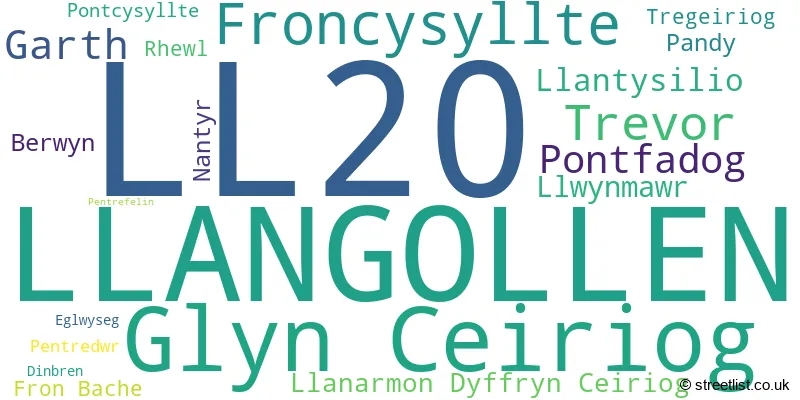
The largest settlement in the LL20 postal code is LLANGOLLEN followed by GLYN CEIRIOG, and TREVOR.
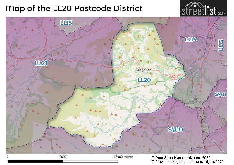
The LL20 Postcode shares a border with LL11 (WREXHAM, GWERSYLLT, COEDPOETH), LL14 (RHOSLLANERCHRUGOG, RUABON, CHIRK), LL21 (CORWEN, LLANDRILLO, CYNWYD) and SY10 (Weston Rhyn, Morda, OSWESTRY).
The primary settlement in the LL20 postcode district is Llangollen, located in Clwyd, Wales. Other significant settlements in the area include Fron Bache, Froncysyllte, Garth, Glyn Ceiriog, Llanarmon Dyffryn Ceiriog, Llwynmawr, Nantyr, Pandy, Pontcysyllte, Pontfadog, Rhewl, Tregeiriog, and Trevor. The main post town for this district is Llangollen.
For the district LL20, we have data on 3 postcode sectors. Here's a breakdown: The sector LL20 7, covers Glyn Ceiriog and Froncysyllte and Trevor in Clwyd. The sector LL20 8, covers Llangollen in Clwyd. The sector LL20 9 is non-geographic. It's often designated for PO Boxes, large organisations, or special services.

Map of the LL20 Postcode District
Explore the LL20 postcode district by using our free interactive map.
When it comes to local government, postal geography often disregards political borders. However, for a breakdown in the LL20 District: the district mostly encompasses the Sir Ddinbych - Denbighshire (199 postcodes), and finally, the Wrecsam - Wrexham area (184 postcodes).
Recent House Sales in LL20
| Date | Price | Address |
|---|---|---|
| 06/10/2023 | £125,000 | Market Street, Llangollen, LL20 8PS |
| 29/09/2023 | £150,000 | Queen Street, Llangollen, LL20 8LF |
| 25/08/2023 | £167,500 | High Street, Glyn Ceiriog, Llangollen, LL20 7EH |
| 25/08/2023 | £227,796 | Pen Y Graig, Froncysyllte, Llangollen, LL20 7RT |
| 24/08/2023 | £335,000 | Dolywern, Pontfadog, Llangollen, LL20 7AG |
| 18/08/2023 | £240,000 | Mill Street, Llangollen, LL20 8RQ |
| 17/08/2023 | £110,000 | Jeffreys Terrace, Pontcysyllte, Llangollen, LL20 7YS |
| 10/08/2023 | £425,000 | Holyhead Road, Llangollen, LL20 7PR |
| 28/07/2023 | £210,000 | Woodlands Road, Froncysyllte, Llangollen, LL20 7SA |
| 28/07/2023 | £145,000 | Greenfield, Llangollen, LL20 8PP |
Weather Forecast for LL20
Press Button to Show Forecast for Llangollen Youth Hostel
| Time Period | Icon | Description | Temperature | Rain Probability | Wind |
|---|---|---|---|---|---|
| 09:00 to 12:00 | Partly cloudy (day) | 8.0°C (feels like 7.0°C) | 1.00% | NNE 4 mph | |
| 12:00 to 15:00 | Sunny day | 10.0°C (feels like 8.0°C) | 0.00% | N 7 mph | |
| 15:00 to 18:00 | Sunny day | 10.0°C (feels like 8.0°C) | 0.00% | NNW 9 mph | |
| 18:00 to 21:00 | Sunny day | 8.0°C (feels like 6.0°C) | 1.00% | NNW 7 mph | |
| 21:00 to 00:00 | Clear night | 4.0°C (feels like 2.0°C) | 0.00% | WNW 4 mph |
Press Button to Show Forecast for Llangollen Youth Hostel
| Time Period | Icon | Description | Temperature | Rain Probability | Wind |
|---|---|---|---|---|---|
| 00:00 to 03:00 | Clear night | 3.0°C (feels like 1.0°C) | 1.00% | W 2 mph | |
| 03:00 to 06:00 | Cloudy | 3.0°C (feels like 1.0°C) | 4.00% | W 4 mph | |
| 06:00 to 09:00 | Cloudy | 5.0°C (feels like 3.0°C) | 5.00% | W 4 mph | |
| 09:00 to 12:00 | Cloudy | 8.0°C (feels like 6.0°C) | 6.00% | NW 9 mph | |
| 12:00 to 15:00 | Partly cloudy (day) | 9.0°C (feels like 7.0°C) | 7.00% | NW 9 mph | |
| 15:00 to 18:00 | Cloudy | 9.0°C (feels like 7.0°C) | 7.00% | NW 9 mph | |
| 18:00 to 21:00 | Partly cloudy (day) | 8.0°C (feels like 7.0°C) | 2.00% | NNW 7 mph | |
| 21:00 to 00:00 | Cloudy | 5.0°C (feels like 4.0°C) | 5.00% | NNW 4 mph |
Press Button to Show Forecast for Llangollen Youth Hostel
| Time Period | Icon | Description | Temperature | Rain Probability | Wind |
|---|---|---|---|---|---|
| 00:00 to 03:00 | Cloudy | 5.0°C (feels like 3.0°C) | 9.00% | SW 4 mph | |
| 03:00 to 06:00 | Cloudy | 4.0°C (feels like 2.0°C) | 11.00% | SSE 4 mph | |
| 06:00 to 09:00 | Cloudy | 4.0°C (feels like 2.0°C) | 12.00% | SE 4 mph | |
| 09:00 to 12:00 | Overcast | 7.0°C (feels like 5.0°C) | 16.00% | SE 7 mph | |
| 12:00 to 15:00 | Overcast | 8.0°C (feels like 6.0°C) | 16.00% | SE 9 mph | |
| 15:00 to 18:00 | Cloudy | 9.0°C (feels like 7.0°C) | 15.00% | ENE 7 mph | |
| 18:00 to 21:00 | Cloudy | 8.0°C (feels like 6.0°C) | 17.00% | ENE 7 mph | |
| 21:00 to 00:00 | Overcast | 6.0°C (feels like 4.0°C) | 20.00% | ENE 7 mph |
Press Button to Show Forecast for Llangollen Youth Hostel
| Time Period | Icon | Description | Temperature | Rain Probability | Wind |
|---|---|---|---|---|---|
| 00:00 to 03:00 | Cloudy | 5.0°C (feels like 3.0°C) | 20.00% | ENE 7 mph | |
| 03:00 to 06:00 | Light rain | 5.0°C (feels like 3.0°C) | 49.00% | SE 4 mph | |
| 06:00 to 09:00 | Light rain | 5.0°C (feels like 3.0°C) | 48.00% | SE 4 mph | |
| 09:00 to 12:00 | Overcast | 7.0°C (feels like 5.0°C) | 21.00% | E 9 mph | |
| 12:00 to 15:00 | Light rain | 9.0°C (feels like 7.0°C) | 48.00% | NE 9 mph | |
| 15:00 to 18:00 | Light rain | 10.0°C (feels like 8.0°C) | 49.00% | NE 9 mph | |
| 18:00 to 21:00 | Light rain shower (day) | 9.0°C (feels like 7.0°C) | 39.00% | N 7 mph | |
| 21:00 to 00:00 | Cloudy | 8.0°C (feels like 6.0°C) | 16.00% | N 7 mph |
Where is the LL20 Postcode District?
The LL20 postcode district is located in the town of Llangollen. It is situated near several nearby towns, including Wrexham to the Northeast (7.59 miles away), Corwen to the Northwest (8.22 miles away), Oswestry to the Southeast (8.86 miles away), Ruthin to the North (11.05 miles away), and Llanfechain to the South (11.54 miles away). Additionally, the postcode district is approximately 164.35 miles away from the center of London.
The district is within the post town of LLANGOLLEN.
The sector has postcodes within the nation of Wales.
The LL20 Postcode District is covers the following regions.
- Flintshire and Wrexham - East Wales - Wales
- Conwy and Denbighshire - West Wales - Wales
| Postcode Sector | Delivery Office |
|---|---|
| LL20 7 | Llangollen Delivery Office |
| LL20 8 | Llangollen Delivery Office |
| L | L | 2 | 0 | - | X | X | X |
| L | L | 2 | 0 | Space | Numeric | Letter | Letter |
Tourist Attractions within the Postcode Area
We found 1 visitor attractions within the LL20 postcode area
| Valle Crucis Abbey |
|---|
| View Valle Crucis Abbey on Google Maps |
Current Monthly Rental Prices
| # Bedrooms | Min Price | Max Price | Avg Price |
|---|---|---|---|
| 1 | £600 | £600 | £600 |
| 3 | £1,400 | £1,400 | £1,400 |
Current House Prices
| # Bedrooms | Min Price | Max Price | Avg Price |
|---|---|---|---|
| £130,000 | £250,000 | £190,000 | |
| 1 | £120,000 | £150,000 | £140,000 |
| 2 | £45,000 | £275,000 | £171,639 |
| 3 | £124,950 | £610,000 | £305,898 |
| 4 | £275,000 | £750,000 | £438,995 |
| 5 | £349,950 | £825,000 | £548,119 |
| 8 | £500,000 | £540,000 | £520,000 |
| 9 | £750,000 | £1,300,000 | £1,025,000 |
Estate Agents who Operate in the LL20 District
| Logo | Name | Brand Name | Address | Contact Number | Total Properties |
|---|---|---|---|---|---|
 | Llangollen | Wingetts | 12 Castle Street, Llangollen LL20 8NU | 01978 804435 | 19 |
 | Llangollen | Bowen | 34 Castle Street Llangollen, LL20 8RT | 01978 804442 | 11 |
 | Oswestry | Town & Country Property Services | Willow Street, Oswestry SY11 1AA | 01691 881259 | 10 |
 | Oswestry | Bowen | 35 Bailey Street, Oswestry, SY11 1PX | 01691 887786 | 4 |
 | Wrexham | Reid & Roberts | 6 High Street, Wrexham, LL13 8HP | 01978 803774 | 3 |
| Type of Property | 2018 Average | 2018 Sales | 2017 Average | 2017 Sales | 2016 Average | 2016 Sales | 2015 Average | 2015 Sales |
|---|---|---|---|---|---|---|---|---|
| Detached | £288,295 | 42 | £278,049 | 49 | £246,281 | 44 | £251,463 | 53 |
| Semi-Detached | £172,973 | 31 | £153,166 | 34 | £162,089 | 27 | £170,296 | 23 |
| Terraced | £129,514 | 31 | £125,409 | 23 | £125,995 | 33 | £134,428 | 37 |
| Flats | £120,188 | 8 | £114,723 | 11 | £117,150 | 10 | £136,034 | 13 |