The LL22 postcode district is a postal district located in the LL Llandudno postcode area with a population of 18,413 residents according to the 2021 England and Wales Census.
The area of the LL22 postcode district is 76.49 square miles which is 198.10 square kilometres or 48,951.28 acres.
Currently, the LL22 district has about 644 postcode units spread across 3 geographic postcode sectors.
Given that each sector allows for 400 unique postcode combinations, the district has a capacity of 1,200 postcodes. With 644 postcodes already in use, this leaves 556 units available.
The largest settlement in the LL22 postal code is ABERGELE followed by TOWYN, and PENSARN.
The postcode area has a boundary with The Irish Sea.
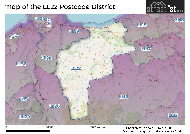
The LL22 Postcode shares a border with LL18 (RHYL, KINMEL BAY, Rhuddlan), LL24 (BETWS Y COED, PENMACHNO, PENTREFOELAS), LL26 (LLANRWST, LLANDDOGED, MAENAN), LL16 (DENBIGH, LLANDYRNOG, HENLLAN) and LL29 (COLWYN BAY, OLD COLWYN, LLYSFAEN).
The primary settlement in the LL22 postcode district is Abergele, located in the county of Clwyd in Wales. Other significant settlements in the area include Pensarn, Betws Yn Rhos, Dolwen, Gwytherin, Llanddulas, Llanfairtalhaiarn, Llangernyw, Moelfre, Pandy Tudur, Rhyd-y-Foel, Trofarth, Glascoed, Groesffordd Marli, Kinmel, Morfa, St. George, and Towyn. The post town associated with this postcode district is Abergele.
For the district LL22, we have data on 3 postcode sectors. Here's a breakdown: The sector LL22 7, covers Abergele and Pensarn in Clwyd. The sector LL22 8, covers Abergele and Llanddulas and Llanfairtalhaiarn and Betws Yn Rhos and Llangernyw in Clwyd. The sector LL22 9, covers Towyn and Abergele in Clwyd.

Map of the LL22 Postcode District
Explore the LL22 postcode district by using our free interactive map.
When it comes to local government, postal geography often disregards political borders. However, for a breakdown in the LL22 District: the district mostly encompasses the Conwy - Conwy (639 postcodes), and finally, the Sir Ddinbych - Denbighshire area (11 postcodes).
Recent House Sales in LL22
| Date | Price | Address |
|---|---|---|
| 06/10/2023 | £200,000 | Maes Seiriol, Abergele, LL22 7RZ |
| 06/10/2023 | £195,000 | Lon Ffawydd, Abergele, LL22 7DY |
| 29/09/2023 | £240,000 | Sea Road, Abergele, LL22 7BU |
| 29/09/2023 | £225,000 | Turnberry Drive, Abergele, LL22 7UD |
| 15/09/2023 | £157,000 | Llys Charles, Towyn, Abergele, LL22 9NP |
| 13/09/2023 | £360,000 | Tan Y Gaer, Abergele, LL22 7JB |
| 11/09/2023 | £220,000 | Llys Dolhaiarn, Llanfairtalhaiarn, Abergele, LL22 8SX |
| 08/09/2023 | £153,500 | School Lane, Llanfairtalhaiarn, Abergele, LL22 8RT |
| 08/09/2023 | £240,000 | Derrie Avenue, Abergele, LL22 7TF |
| 04/09/2023 | £115,000 | Water Street, Abergele, LL22 7SR |
Weather Forecast for LL22
Press Button to Show Forecast for Llanddulas
| Time Period | Icon | Description | Temperature | Rain Probability | Wind |
|---|---|---|---|---|---|
| 06:00 to 09:00 | Cloudy | 6.0°C (feels like 3.0°C) | 7.00% | WNW 13 mph | |
| 09:00 to 12:00 | Cloudy | 8.0°C (feels like 4.0°C) | 16.00% | NW 13 mph | |
| 12:00 to 15:00 | Cloudy | 8.0°C (feels like 6.0°C) | 7.00% | NNW 11 mph | |
| 15:00 to 18:00 | Sunny day | 9.0°C (feels like 6.0°C) | 1.00% | NNW 9 mph | |
| 18:00 to 21:00 | Sunny day | 8.0°C (feels like 6.0°C) | 0.00% | NNW 7 mph | |
| 21:00 to 00:00 | Partly cloudy (night) | 4.0°C (feels like 2.0°C) | 3.00% | NNE 4 mph |
Press Button to Show Forecast for Llanddulas
| Time Period | Icon | Description | Temperature | Rain Probability | Wind |
|---|---|---|---|---|---|
| 00:00 to 03:00 | Cloudy | 4.0°C (feels like 2.0°C) | 8.00% | ESE 4 mph | |
| 03:00 to 06:00 | Partly cloudy (night) | 3.0°C (feels like 1.0°C) | 5.00% | SE 4 mph | |
| 06:00 to 09:00 | Mist | 3.0°C (feels like 1.0°C) | 16.00% | SE 4 mph | |
| 09:00 to 12:00 | Sunny day | 7.0°C (feels like 5.0°C) | 32.00% | ENE 7 mph | |
| 12:00 to 15:00 | Partly cloudy (day) | 8.0°C (feels like 6.0°C) | 32.00% | NE 9 mph | |
| 15:00 to 18:00 | Cloudy | 8.0°C (feels like 6.0°C) | 5.00% | NNE 7 mph | |
| 18:00 to 21:00 | Sunny day | 8.0°C (feels like 6.0°C) | 4.00% | NE 7 mph | |
| 21:00 to 00:00 | Partly cloudy (night) | 6.0°C (feels like 4.0°C) | 4.00% | ENE 7 mph |
Press Button to Show Forecast for Llanddulas
| Time Period | Icon | Description | Temperature | Rain Probability | Wind |
|---|---|---|---|---|---|
| 00:00 to 03:00 | Partly cloudy (night) | 6.0°C (feels like 4.0°C) | 6.00% | ESE 4 mph | |
| 03:00 to 06:00 | Partly cloudy (night) | 4.0°C (feels like 2.0°C) | 6.00% | SSE 4 mph | |
| 06:00 to 09:00 | Partly cloudy (day) | 5.0°C (feels like 3.0°C) | 6.00% | SE 4 mph | |
| 09:00 to 12:00 | Partly cloudy (day) | 8.0°C (feels like 6.0°C) | 6.00% | E 9 mph | |
| 12:00 to 15:00 | Cloudy | 9.0°C (feels like 7.0°C) | 10.00% | ENE 9 mph | |
| 15:00 to 18:00 | Cloudy | 9.0°C (feels like 7.0°C) | 12.00% | NE 9 mph | |
| 18:00 to 21:00 | Cloudy | 9.0°C (feels like 6.0°C) | 12.00% | NE 9 mph | |
| 21:00 to 00:00 | Overcast | 8.0°C (feels like 6.0°C) | 15.00% | NE 9 mph |
Press Button to Show Forecast for Llanddulas
| Time Period | Icon | Description | Temperature | Rain Probability | Wind |
|---|---|---|---|---|---|
| 00:00 to 03:00 | Cloudy | 7.0°C (feels like 4.0°C) | 16.00% | ENE 9 mph | |
| 03:00 to 06:00 | Cloudy | 6.0°C (feels like 3.0°C) | 16.00% | NE 11 mph | |
| 06:00 to 09:00 | Light rain | 7.0°C (feels like 4.0°C) | 46.00% | NE 11 mph | |
| 09:00 to 12:00 | Cloudy | 8.0°C (feels like 5.0°C) | 19.00% | NNE 11 mph | |
| 12:00 to 15:00 | Cloudy | 9.0°C (feels like 6.0°C) | 16.00% | N 11 mph | |
| 15:00 to 18:00 | Partly cloudy (day) | 10.0°C (feels like 7.0°C) | 12.00% | NNW 11 mph | |
| 18:00 to 21:00 | Sunny day | 9.0°C (feels like 7.0°C) | 10.00% | NW 11 mph | |
| 21:00 to 00:00 | Clear night | 8.0°C (feels like 5.0°C) | 8.00% | W 9 mph |
Where is the LL22 Postcode District?
The LL22 postcode district is located in the town of Abergele. Abergele is surrounded by several nearby towns, including Colwyn Bay to the North West, Llanrwst to the South West, St. Asaph to the East, Conwy to the West, and Rhyl to the North East. Additionally, Abergele is approximately 189.9 miles away from the center of London.
The district is within the post town of ABERGELE.
The sector has postcodes within the nation of Wales.
The LL22 Postcode District is in the Conwy and Denbighshire region of West Wales within the Wales.
| Postcode Sector | Delivery Office |
|---|---|
| LL22 7 | Rhyl Delivery Office |
| LL22 8 | Rhyl Delivery Office |
| LL22 9 | Rhyl Delivery Office |
| L | L | 2 | 2 | - | X | X | X |
| L | L | 2 | 2 | Space | Numeric | Letter | Letter |
Current Monthly Rental Prices
| # Bedrooms | Min Price | Max Price | Avg Price |
|---|---|---|---|
| 2 | £875 | £875 | £875 |
| 4 | £1,300 | £2,000 | £1,650 |
Current House Prices
| # Bedrooms | Min Price | Max Price | Avg Price |
|---|---|---|---|
| £80,000 | £280,000 | £233,571 | |
| 1 | £42,000 | £165,000 | £109,651 |
| 2 | £29,995 | £575,000 | £182,704 |
| 3 | £35,000 | £995,000 | £244,272 |
| 4 | £215,000 | £1,100,000 | £449,385 |
| 5 | £140,000 | £995,000 | £515,667 |
| 6 | £385,000 | £895,000 | £620,000 |
| 7 | £425,000 | £575,000 | £500,000 |
| 9 | £420,000 | £420,000 | £420,000 |
| 10 | £2,195,000 | £2,195,000 | £2,195,000 |
Estate Agents who Operate in the LL22 District
| Logo | Name | Brand Name | Address | Contact Number | Total Properties |
|---|---|---|---|---|---|
 | Abergele | Peter Large Estate Agents | 45-47 Market Street, Abergele, LL22 7AF | 01745 770912 | 66 |
 | Abergele | Prys Jones & Booth | Nelson House Water Street, Abergele, LL22 7SH | 01745 770926 | 56 |
 | Preston | Tempo Estates | 12 - 14 Preston Old Road, Freckleton, Preston, PR4 1PD | 01772 633399 | 11 |
 | Rhyl | Williams Estates | 17-19 Kinmel Street, Rhyl, LL18 1AH | 01745 770478 | 10 |
 | St. Asaph | Idris Estates | St. Asaph | 01745 771078 | 10 |
- Abergele
- Bae Colwyn
- Belgrano
- Betws-yn-Rhos
- Bodelwyddan
- Brymbo
- Bryn-y-maen
- Glascoed
- Graig
- Kinmel Bay
- Llanddoged
- Llanddulas
- Llanelian-yn-Rh�s
- Llanfair Talhaiarn
- Llangernyw
- Llannefydd
- Llansan Sior
- Llansannan
- Llysfaen
- Melin-y-coed
- Mynydd Marian
- Pensarn
- Pentre'r Felin
- Rhyd-y-foel
- Saint Asaph Business Park
- Terfyn
- Terfyn
- Towyn
| Type of Property | 2018 Average | 2018 Sales | 2017 Average | 2017 Sales | 2016 Average | 2016 Sales | 2015 Average | 2015 Sales |
|---|---|---|---|---|---|---|---|---|
| Detached | £204,778 | 226 | £203,307 | 213 | £181,115 | 189 | £178,028 | 155 |
| Semi-Detached | £134,782 | 130 | £132,744 | 126 | £121,645 | 111 | £117,810 | 80 |
| Terraced | £109,429 | 47 | £114,200 | 37 | £114,334 | 31 | £102,455 | 31 |
| Flats | £103,041 | 16 | £90,875 | 12 | £88,540 | 15 | £85,886 | 22 |